Town: SAXMUNDHAM
District Council: EAST SUFFOLK (previously Suffolk Coastal)
TM 389 625
Not open to the public
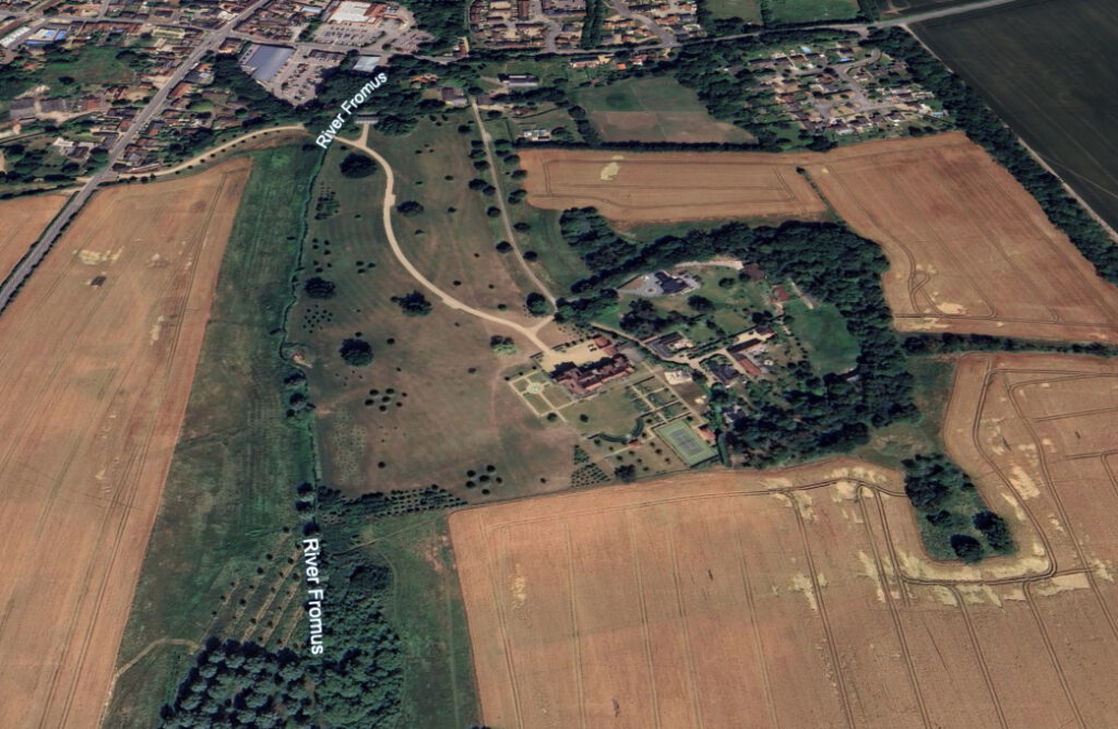
Taking its name from the manor of Hurts, Hurts Hall (Grade II) stands in its own park south of the town of Saxmundham. It is on rising ground in the valley of the River Fromus, which flows south to join the River Alde near Snape. The town’s Church of St John the Baptist (Grade II*) dating back to the fourteenth century is on the edge of the park c. 450m (1,475ft) north of the house. In 1841 the rector was the Revd Lancelot Brown, grandson of the famous landscape designer Lancelot ‘Capability’ Brown, who was also rector of the parishes of Carlton and of Kelsale where he made his home. The southern part of the park was in the neighbouring parish of Sternfield.
OWNERS
The manor of Hurts is believed to have been in the ownership of Thomas de Verley during the thirteenth century who possibly built the first house on the site. It was later transferred to the nunnery at Marham in Norfolk and after the dissolution of the monasteries was granted to Sir Nichols Hare c. 1535. It passed through numerous hands before acquired by the Long family in the eighteenth century. They made their fortune from their Jamaican plantations at Longville, the largest plantation in Jamaica. Charles Long (1679–1723), the son of Samuel Long of Longville, succeeded his father as an infant. Charles came to England and bought the extensive Hurts Hall Estate in the early part of the eighteenth century. He became an MP for Dunwich, one of the ‘rotten boroughs’ that were so named because it had two MPs even though it had lost most of its population due to coastal erosion. His son, also Charles (1705–78), inherited the property on his father’s death in 1723, later marrying Mary, daughter and heir of Dudley North Esq. of nearby Glemham Hall (Grade II).
In 1778 their son, also Charles (1748–1812), inherited the estate and married his cousin Jane, daughter of Beeston Long Esq. of Carshalton Park in Surrey. They had two sons who died in infancy so on Charles’ death in 1812 the Hurts Hall Estate was inherited by his younger brother Dudley (b. 1749), although in his will he stipulated it be held in trust to support an annuity for his wife Jane. In 1789 Dudley is said to have changed his name to North to become Dudley Long North so he could inherit neighbouring Little Glemham from his aunt, basing himself at Glemham Hall. He died childless in 1829 and under the terms of Charles Long’s will it eventually passed to William Long (1802–75), son of Beeston Long. William made Hurts Hall his home and became a Justice of the Peace and High Sheriff of Suffolk. He stayed at Hurts Hall until his death in 1875 and it passed down the Long family line who continued to make it their home for the next sixty five years. During World War II the Hall and park were requisitioned by the Army and used by Major-General Sir Percy Hobart as his headquarters while he tested, developed and trained his units in the use of his ‘Funnies’. These were a number of unusually modified tanks that operated during the war with an important role in the D-Day landings. It has been said that Churchill, Eisenhower and Montgomery met at Hurts Hall to discuss preparations for the landings.
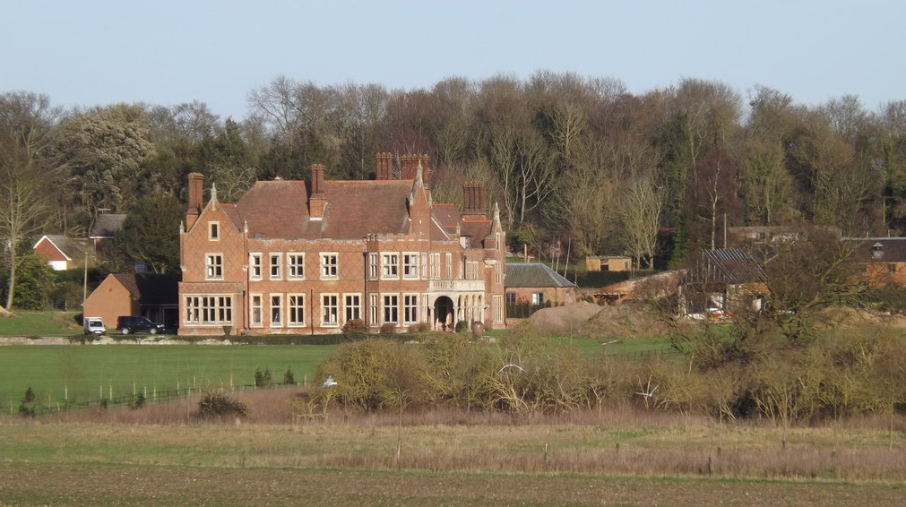
After the war the Long family sold the estate and many family portraits from the house were donated to Christchurch Mansion in Ipswich with the family papers given to Suffolk Record Office. There followed various owners and a period during which the Hall slowly fell into disrepair with much of the parkland sold off. In 2012 the new owners of Hurts Hall began the process of restoration of the house and remaining parkland, while the various early-nineteenth century outbuildings, such as the stables, walled garden and granary, were converted for residential use and are now in separate ownership
THE HALL
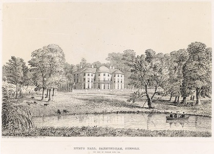
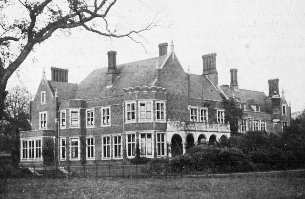
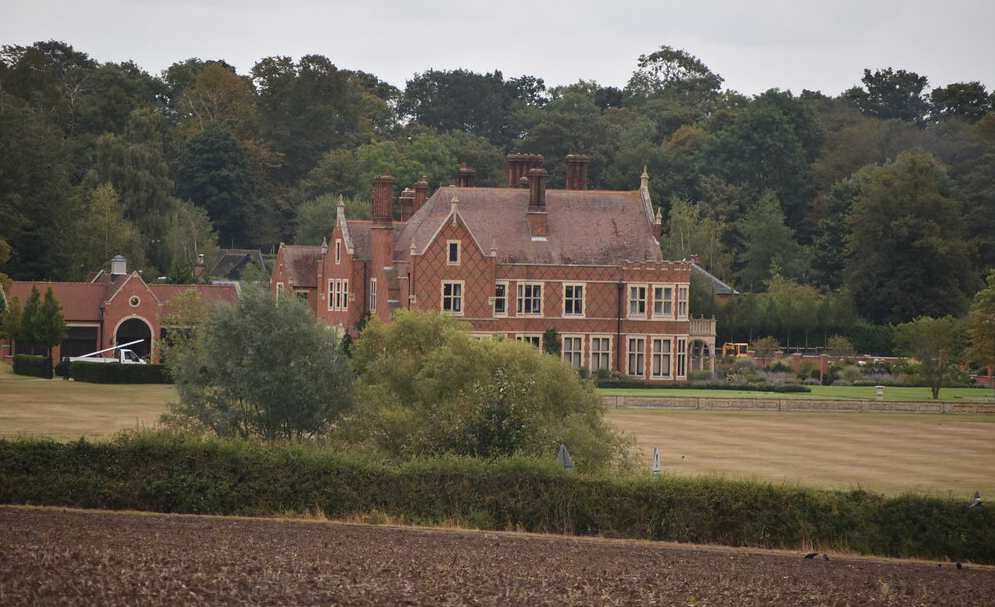
A previous building, which is believed to have been built c. 1650, was replaced in 1803 by a Regency mansion to designs by Samuel Wyatt (1737–1807) for Charles Long, Esq. (1748–1812). This house is depicted in a lithograph by Henry Davy dated 1857, which shows a house that was described in 1874 as ‘a large and handsome white brick mansion’. Its principal elevation faced west to overlook the parkland with an entrance front to the north. It was badly damaged by fire in 1890 and the present red brick country house in the Jacobean style to designs by the architect Thomas Cotman, who was also known for a number of notable buildings in Felixstowe and Ipswich, replaced it in 1893.
PARK
Hurts Hall sits in the remains of a park developed by the Long family from the eighteenth century. Having inherited the estate in 1778, Charles Long (1748–1812) was responsible for laying out and planting the grounds, including expanding the River Fromas into a sheet of water, which is shown on the 1857 lithograph to have been used for boating and providing a suitable setting for his Regency mansion. In his directory of 1855, William White described the house as ‘pleasantly situated, and has a cheerful aspect’ with the grounds having ‘some fine timber about the park’, ‘with their gentle undulations, form a pretty object as seen from the main road, which passes through them’. Its extensive park extended northward to the church, southward to the village of Sternfield and westward to the main road into Saxmundham, today the B1121 and known as South Entrance. The parkland setting was extended westward by an area known as The Layers which, although in agricultural use by 1840, gave rural views beyond the park from the house. Shelterbelts of trees formed the north, east and south park boundaries with clumps and freestanding trees within the formal parkland landscape, said to have extended to c. 81ha (200a).
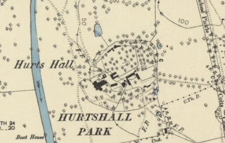
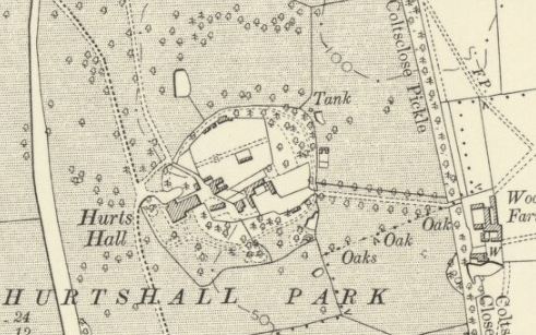
By the time the tithe map to accompany the 1841 apportionment was surveyed in 1840 three drives served the Hall site: one from Sternfield village from the south; another from the Saxmundham to Leiston road to the north that passed the church to arrive at the stables east of the house and the third and main drive from the northwest near the southern end of Saxmundham High Street before bridging the river and sweeping through the parkland to the western entrance front. Both northern drives passed through a shelterbelt of trees, on the 1885 OS map named ‘Lodge Plantation’. A tree-lined access drive was created sometime between 1841 and 1885 linking the Hurts Hall granary and stables to nineteenth century Wood Farm, which was built at the edge of the eastern shelterbelt. There were no lodges shown on the tithe map at the entrances into the park, although by 1885 a lodge had been built at the north-west entrance and a further lodge at the Sternfield entrance appeared sometime between 1905 and 1928. A boat house in full view of the house on the widened River Fromus is marked on the 1885 OS map, although it is likely to have been a feature at a much earlier date.
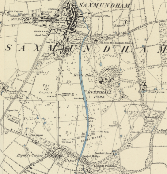
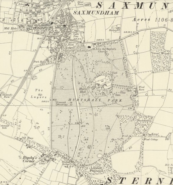
In 1911 outer parts of estate were put up for sale by William E. Long Esq., although the formal parkland stayed intact until the second half of the twentieth century when the southern park was lost to agriculture resulting in the loss of the drive from Sternfield. Since then a housing development has been built in the north-east corner of the parkland, the eastern parkland and the area between the B1121 and the River Fromus are now also in agricultural use leaving just the north-west section of the original formal park surviving. The house is now accessed through new entrance gates further south along the B1121 and the drive, lined with lime trees, now curves in a wide sweep from the original bridge over the river to the new entrance. Although still visible from the road, the old entrance gates only give access to a narrow trackway that was once part of the original drive. Throughout the surviving parkland there are now fewer freestanding trees that allow longer views from the Hall, especially in the area to the south.
PLEASURE GARDENS
The 1840 tithe map shows that woodland almost completely surrounded the Hall site, creating an oval enclosure inside which were the house, a large five-sided walled garden, stables, granary and other farm buildings. A circular path ran through the belt of trees and into an open area of garden on the western side of the enclosure giving views across the parkland over a lawn from both southern and western elevations of the house. In this area the oval enclosure was continued by a ha-ha. Access into the enclosure were on the east side from the parkland, a northern drive from the church and the main drive to the west, with a footpath leading out into the southern parkland.
There was little change to the layout of the pleasure gardens over the following forty-five years with the 1885 map showing a lawn dotted with occasional specimen trees as shown on the earlier tithe map. By 1905 the shape of the ha-ha had been changed slightly with a ‘bulge’ added to the south and a more formalised layout of paths flanked by two trees had been added in front of the house.
The decline of the house during the second half of the twentieth century saw a corresponding decline in the upkeep of the gardens. Since 2012 and the start of the major restoration and development of the site the pleasure gardens have expanded substantially with numerous additional features added.
WALLED GARDEN
The walls of the large pentagonal walled gardens have been described as having an eighteenth century appearance by the architectural historian, Leigh Alston, and thus would pre-date the building of the Regency house in 1803, perhaps built for Charles Long (1705–78) after his marriage to Mary, the Dudley North heiress. Alternatively they may have been built for his son, also Charles (1748–1812), who inherited the estate in 1778. If the walls are of a slightly later date they are more likely to be contemporary with the building of the Regency house and would have been part of the improvements undertaken by son Charles.
In 1840 the walled garden had cross- and perimeter paths creating eight planting sections with a building, possibly an orangery, at the junction of the two more northern walls. By the end of the nineteenth century further glasshouses had been added on either side of the original glasshouse which survived into the latter part of the twentieth century.
Since the beginning of the twenty-first century a number of additional residential properties have been built on the site of the Hall Farm, the original farm complex immediately east of the house and within the oval enclosure. Some are conversions of the original stables and farm buildings and others new, such as a house within the northern section of the walled garden where some walls have survived in a degraded form.
In 2025 the landscape setting of Hurts Hall and Park is threatened by the cumulative effects of housing development proposed for The Layers and energy and infrastructure projects such as Sizewell C, Sealink, Lionlink and Nautilus pipelines. Within an agricultural setting, the present views from the house and from the B1121 over the parkland towards the house will be impacted by the siting of an access road bridging the River Fromus south of the house leading through woodland to potentially three large convertor stations to the east at Wood Farm and in Friston. The scale of the projects means suggested planting schemes will in no way mitigate the severe visual impact on the setting of Hurts Hall.
SOURCES:
Alston, Leigh, Hall Farm, Saxmundham, Suffolk. Historic Building Record, February 2009 for Suffolk County Council.
Barker, H., R. East Suffolk Illustrated, 1908.
Birch, Mel, Suffolk’s Ancient Sites Historic Places, 2004.
Burke, John, A Genealogical and Heraldic History of the Commoners of Great Britain and Ireland…, 1836.
Burke, Sir Bernard, A Visitation of the Seats and Arms of the Noblemen and Gentlemen of Great Britain & Ireland, 1855.
Burlock, Hillary, Rotten Boroughs. Eighteenth-Century Political Participation & Electoral Culture (ECPPEC) project. https://ecppec.ncl.ac.uk/features/rotten-boroughs/ (accessed January 2025).
Davy, Henry, Views of the seats of noblemen and gentlemen in Suffolk, 1824–26.
Kelly’s Directory, 1922.
Page, Augustine, Topographical and Genealogical, The County of Suffolk, A Supplement to the Suffolk Traveller (of J. Kirby), compiled 1811 and published in 1847 by Page, Joshua.
Pevsner, N. & Radcliffe, E., Suffolk, 2nd Edition, 1974.
Sedgwick, Romney, R. (ed), ‘LONG, Charles (1679-1723), of Hurts Hall, Saxmundham, Suffolk’ in The History of Parliament: the House of Commons 1715-1754, 1970.
Suffolk Coastal District Council Heritage Impact Assessment: South Saxmundham Garden Neighbourhood, November 2018.
The Gentlemen’s Magazine, 1829.
University College London, Legacies of British Slave-ownership, Charles Long of Hurts Hall, https://www.ucl.ac.uk/ibs/person/view/2146633756 (accessed May 2019). Sourced from Robert Mowbray Howard, Records and letters of the family of the Longs of Longville, Jamaica, and Hampton Lodge, Surrey, Vol 1, 1925.
White, William, History, Gazetteer, and Directory of Suffolk…, 1844, 1855.
http://www.saxmundham.org/aboutsax/buildings.html (accessed May 2019).
https://www.glemhamhall.co.uk/history-1 (accessed January 2025).
http://thepeerage.com/p27614.htm (accessed October 2019).
www.stedmundsburychronicle.co.uk/Chronicle/1900-1945.htm (accessed October 2019).
http://warfarehistorynetwork.com/daily/wwii/general-percy-hobart-britains-genius-tanker/ (accessed October 2019).
https://www.greatbritishlife.co.uk/magazines/suffolk/23259763.quick-guide-saxmundham-gateway-suffolk-coast/; https://www.thesuffolkcoast.co.uk/shares/Saxmundham-Pocket-Guide-August-2022.pdf (accessed January 2025).
http://www.saxmundham.org/aboutsax/buildings.html (accessed May 2019).
http://www.saxstjohns.org.uk/saint-johns-a-history/church-guide-the-story-of-st-john-the-baptist/11/ Church Guide of St John the Baptist Church, (accessed May 2019).
https://www.chrisdeakin.co.uk/?blog=blogs/archive/2018/10/01/garden.design.ipswich.aspx Chris Deakin Garden Design, (accessed June 2019).
Census: 1841, 1871, 1881, 1901, 1911.
Hodskinson’s Map of Suffolk in 1783.
1841 (surveyed 1840) tithe map and apportionment.
1885 (surveyed 1881 to 1883) Ordnance Survey map.
1905 (revised 1903) OS map.
1928 (revised 1925) OS map.
1951 (revised 1946 to 1948) OS map.
2023 Google Earth
Heritage Assets:
Suffolk Historic Environment Record (SHER): SXM 008, SXM 021, SXM 076, SXM 077.
Hurts Hall, Saxmundham (Grade II), Historic England No: 1268178.
Church of St John Baptist (Grade II*), Historic England No: 1268184.
Glemham Hall (Grade II), Historic England No: 1001461.
Suffolk Record Office (now Suffolk Archives):
SRO (Ipswich) FC137/C/2/1 Deed of Exchange of the parsonage house and garden, 1783.
SRO HD2833/2/SC242/31/34, Sales particulars for an agricultural estate, part of Hurts Hall Estate, 841 acres, 1 August 1911.
Site ownership: Private
Study written: February 2025
Type of Study: Desktop and external visit
Written by: Tina Ranft
Amended:
