Parish: AKENHAM
District Council: MID SUFFOLK
TM 146 484
Not open to the public
In an isolated position in the parish of Akenham with its sparce dispersed settlement, Rise Hall (Grade II) lies close to St Mary’s Church (Grade II*), both of which can be reached only by private tracks, a restricted byway or public footpaths. Although remote, it lies on rising ground and overlooks Ipswich, the town centre being less than c. 4.8km (3mls) to the south, and is close to its northern outskirts.
Thought to have originally been called Rous Hall, Rise Hall was the site of the manor house for the le Ruse or Rous family from as early as the thirteenth century – the church has surviving features that probably date from this period. Amalgamated with Akenham manor, it passed through a number of owners and is believed to have acquired the name Rise Hall c. 1604.
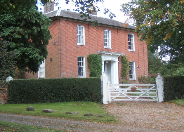
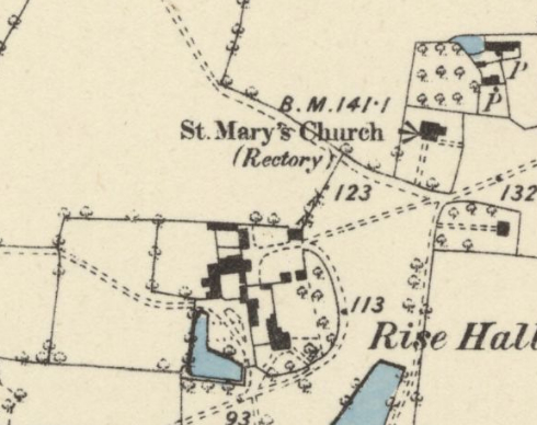
The present house replaced an earlier house on the site, possibly one built in the seventeenth century that is likely to have been in a walled enclosure, as was the fashion during that period. It was built in 1826 for Robert Woodward, Esq. (b. 1791), son of the Revd Thomas Woodward of Sproughton Hall. At the time of the tithe apportionment of 1837 Robert was registered as the occupant farmer but it was owned by his father, although ownership had transferred to Robert by 1855. The accompanying tithe map shows the house with a semi-circular front garden enclosure to the east, bounded by a track from the south-west that acted as the entrance drive that led to the church, and a small attached yard to the rear. Beyond this yard to the west was a further yard within which was a L-shaped pond, probably the remains of a moat that still exists today associated with the earlier manor house. Farm buildings occupied an enclosure to the north. To raise the status of his home, Robert was probably responsible for developing an irregularly-shaped ‘park’ around the house, made up of park-like pasture distinguished from surrounding fields by shading on the tithe map. Within the ‘park’ were a field named ‘Old Orchard’ to the west of the house and an area named ‘The Knole’ – meaning a small hill with a rounded top – which refers to a surviving island within a ditch south of the house. This is likely to have been the site of a moated dovecote and, given its prominent position in relation to the house, it may later have become a focal point of interest incorporated into the wider garden landscape. Also within the ‘park’ was a large oblong pond to the south-east that probably had its origins as a medieval fishpond, which also survives today.
In 1874 Robert Woodward died and soon after a young Joseph Alfred Smith (b. c. 1854) took over Rise Hall and its farm of c. 101ha (250a). An innovator with fresh ideas, Joseph won numerous awards for his livestock breeding and founded the Akenham Dairy Company to which Suffolk farmers sold their milk for butter and cheese production. To improve ways of working and accommodation for his dairies, during the 1880s new farm buildings were added to the existing farmyard and by this time a new drive had been added to the south that is the main entrance today. The dairy company at Rise Hall set an example of good butter and cheese making, especially for cheddar cheese, and keen to spread better practice to the wider community, Robert set up the Eastern Counties Dairy Institute at Rise Hall in 1888. Soon after Ransomes, Sims and Jefferies engineers in Ipswich proudly announced in an advertisement that they had supplied the Institute with a steam engine and boiler for their dairy. The Institute moved to Gippeswyk Park in Ipswich the following year where its work could be expanded for more students and Joseph and his family moved to Gippeswyk Hall c. 1900 from where he stayed as principle or secretary of the Institute for many years. However, the 1901 censuses give Robert’s profession as farmer and manager of the Institute living at Gippeswyk Hall and the new resident at Rise Hall as Lauchlan Rose, a silk manufacturer, which raises the possibility that Robert continued to farm the land at Rise Hall with Lauchlan and his family as purely residential tenants of the house.
By 1911 a farm bailiff had been brought in to run the farm from Rise Hall, by 1916 the house had become a private residence, detached from the farm. The Rise Hall Estate came up for sale in 2010 when it was sold as c. 71ha (175a), including mature woodland, pasture and arable fields. Over the following years the owners continued to farm the land and sought ways to diversify the farmhouse complex assets. Two barns to the rear of the house had previously received planning consent to convert into two dwellings and the wider site became the film set for a First World War film, including replica trenches that also featured in the television programme Downton Abbey. By 2020 the house had been refurbished and advertised for rent, including a partly walled kitchen garden, and in 2022 the farm buildings in c. 0.4ha (1a), including barns in a poor state of repair that appear to range in date from as early as the seventeenth century, were offered for sale as a residential development opportunity.
SOURCES:
Copinger, W. A., The Manors of Suffolk, Vol. 2, 1908.
Kelly, Post Office Directory of Cambridgeshire, Norfolk, and Suffolk, 1858.
Thirsk, Joan, ‘Suffolk Farming in the Nineteenth Century’, 1958, Suffolk Records Society.
White, William, History, Gazetteer, and Directory of Suffolk, 1855.
The Journal of the Royal Agricultural Society of England, Second Series, Vol. 24, 1888 (accessed at https://www.biodiversitylibrary.org/item/182450#page/9/mode/1up December 2022)
East Anglian Daily Times, 30 October 2020 (Accessed at https://www.eadt.co.uk/news/21333583.historic-farmhouse-site-famous-first-world-war-film-set-available-rent/ December 2022)
Rise Hall for sale. Country Life article, April 2010 (accessed at http://www.countrylife.co.uk/property/country-houses-for-sale-and-property-news/luxury-property-for-sale-in-east-anglia-23608#TCC7BOIQHf4ht05H.99)
Savills sales particulars for the barn complex, 2022.
Censuses for 1861, 1871, 1881, 1891, 1901, 1911.
1839 tithe map and apportionment.
1884 (surveyed 1881 to 1883) Ordnance Survey map.
1928 (revised 1925) OS map.
2022 Google aerial map (Imagery © Bluesky, CNES / Airbus, Getmapping plc, Infoterra Lts & Bluesky, Maxar Technologies, Map data © 2022).
Heritage Assets:
Suffolk Historic Environment Record (SHER) AKE 009, AKE 010, AKE 036.
Rise Hall (Grade II), Historic England No: 1033283.
St Mary’s Church (Grade II*), Historic England No: 1352028.
Site ownership: Private
Study written: December 2022
Type of Study: Desktop
Written by: Tina Ranft
Amended:
