Parish: TOSTOCK
District Council: MID SUFFOLK
TL 959 634
Not open to the public
On the central Suffolk clayland plateau, Tostock Place stands in the remains of a late-eighteenth or early-nineteenth century landscape park south of the medieval Church of St Andrew (Grade I), which is east of the main village settlement of Tostock c. 11km (7mls) east of Bury St Edmunds. Today the main A14 dual carriageway runs just south of the site. Due to major alterations and loss of parts of the house it is not listed by Historic England, although it falls within the Tostock Conservation Area. Also on the site, but outside the conservation area, is a listed walled garden (Grade II) with crinkle-crankle or serpentine walls, once part of the estate but now in separate ownership.
The North and Grey families owned the manor and it is said that they had their seat on the site of Tostock Place. The Hearth Tax of 1674 lists it as having nineteenth hearths, a substantial property and much larger than Tostock Hall manor house to the north-west. In the eighteenth century Tostock Place passed by marriage to the Moseley family. It became the property of John Moseley Esq. of Glemham House in Great Glemham, who sold to George Brown Esq., a banker from of Bury St Edmunds, in the early-nineteenth century. Although retaining part of the earlier building, in 1812 George built the new Regency house on the site.
The tithe apportionment of 1843 lists Thomas Brown (1776–1852) as the owner and resident of the property. Thomas was a doctor practising in London with Tostock Place as his country residence. The Tostock Estate, together with Brent Eleigh Hall, passed to his only son George James Edward Brown[e], Esq. (1823–57), a practising barrister. In 1854 George married Catharine Mary Mills who was the daughter of William Mills of Great Saxham Hall. They made their home at Tostock Place but three years later Catharine was left a widow to bring up her two young sons Walter Thomas (b. 1855) and Edward C. (b. 1858). Catharine lived most of the rest of her life at Tostock Place and was still resident in 1901. The Tostock Place Estate stayed in the Brown family until 1905 with the death of Walter Thomas. It was then sold to Sir James William Malcolm of Hoveton Hall, Norfolk, who with his family made it his home until 1920 when it was put up for sale, being described at the time as a small estate of 97ha (240a) with the house ‘in the centre of a well-timbered park of about 50 acres’ (20.23ha). It was bought by the Revd Luis Chandos Francis Temple Morgan-Grenville, Master of Kinloss (1889–1944) who with his family lived there until it was requisitioned by the military during World War II. After the war the house fell into disrepair and most of its south wing was demolished. In 1958 the estate was bought by Alastair Henderson, who was closely involved in village life, including a stint as Chairman of the Parish Council, and made the grounds available for village events. Since then various parts of the site, such as the coach house and the former fives court, later transformed by Alastair Henderson to a village squash court, have been sold off and converted for residential purposes with the main house divided into three properties, the principle being the southern end, which today includes much of the original parkland and is still named Tostock Place.
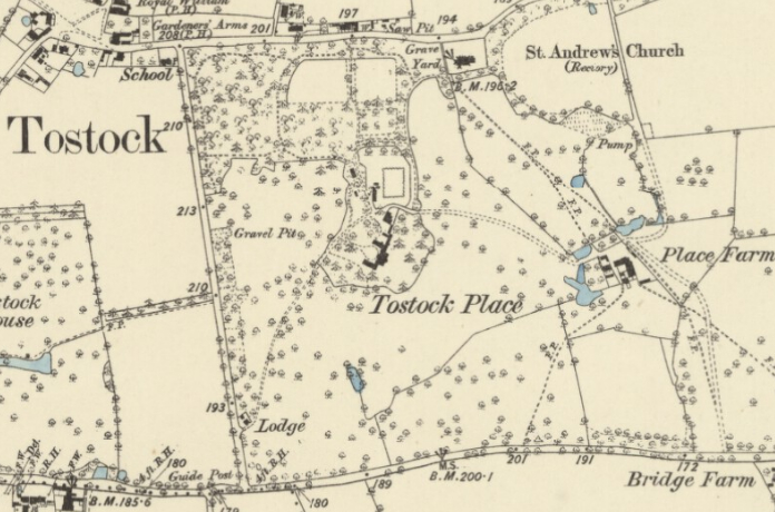
In 1814 the area of parkland surrounding Tostock House was expanded when a road was diverted further west becoming the current ‘New Road’. The detailed 1843 tithe map shows the house centrally in its landscape park with an irregularly-shaped enclosure for the pleasure gardens. A shelterbelt of trees ran along the edge of the new road with an entrance lodge at the southern end. This gave the impression of a long drive through the park alongside the formal gardens as it approached the west side of the house. This shelterbelt plantation continued around the northern boundary of the park along the village street to give privacy to the house. Within the plantation were three separate paddocks, with the rectangular crinkle-crankle walled kitchen garden between the plantations and the house.
Little changed in the park during the following forty years, although by the time of the 1884 OS map one of the paddocks had become an orchard and the plantations are shown to have been predominantly deciduous trees beside New Road, where a small gap had appeared due west of the walled garden, but with some coniferous trees in the northern section with its winding paths, one leading to the parish church. Scattered around the park there were a number of freestanding trees and the pleasure grounds had some areas of lawn and scattered mixed tree plantings, those to the west of the house with winding paths. The map also shows a track leading eastward to the home farm.
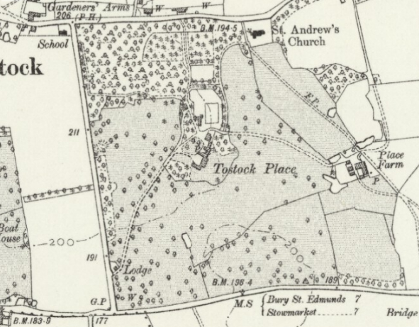
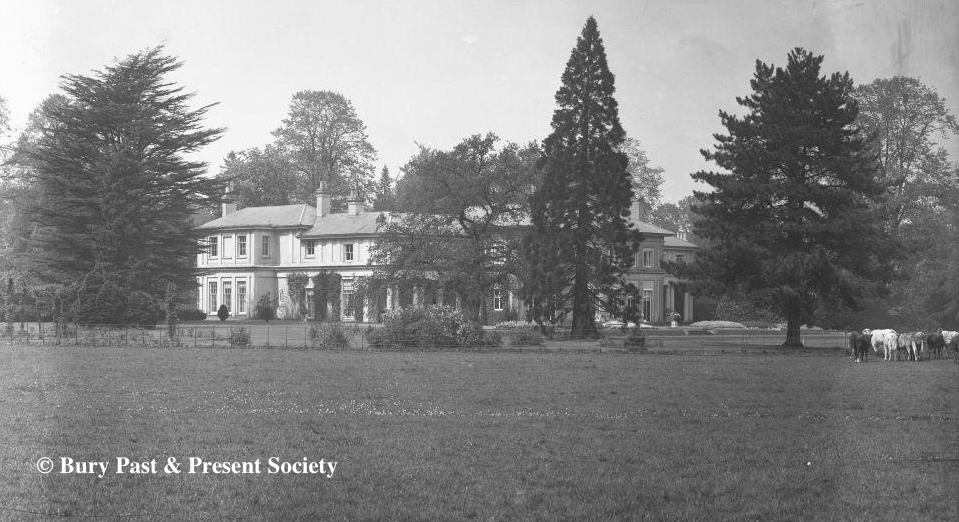
The pleasure gardens around the house appear to have been separated from the parkland by an irregular-shaped boundary, possibly a ha-ha, shown on nineteenth century maps but likely to be of an earlier date. Apart from the addition of tracks to the west and east and the conversion of paddocks to woodland, little appears to have changed in the park and gardens during the twentieth century. A photograph in the Spanton Jarmon Collection, undated but probably early-twentieth century shows the east-facing garden front looked out over parkland with a small area of formal beds and path flanked by planted urns next to the house. Steps led down to a section of a ha-ha-like ditch, where an urn marked its boundary with a lawn and parkland beyond. In the background there are scattered mature specimen trees in the parkland Another photograph of a similar date in the Spanton Jarman Collection shows numerous fruit trees growing against a crinkle-crankle wall in the walled garden with a wide bed and herbaceous plants flanking the perimeter path with a glasshouse in the distance. In the 1960s additional mixed deciduous and conifer trees were planted to further screen the northern edge of the park from the new houses that had been built along its north-western edge. In the early-twentieth century the entrance drive from New Road was replaced by a curving version that now has a lime avenue. The entrance lodge survives although substantially altered and extended.
Today Tostock Place still sits in 20.23 ha (50a) of parkland, with paddocks, stables and formal and informal gardens to south, east and west. New trees have been planted to screen Tostock House from the other properties on the site, which now have their own entrance drive from the north, including giving access to the rectangular red-brick walled garden with off-set pedestrian gateways to the north and south ends that is now mainly lawned and part of the property of the converted coach house. Additional trees have also been added to the south of the house, presumably acting as a barrier against the noise from the major A14 road.
SOURCES:
A Concise Description of Bury St Edmunds and Its Environs Within the Distance of Ten Miles, 1827.
Barker, H. R., West Suffolk Illustrated, 1907.
Burke, Sir Bernard, A Genealogical and Heraldic History of the Landed Gentry of Great Britain and Ireland, Vol I.
Cromwell, T. K., Excursions in the County of Suffolk, Vol. 6, 1818–1819.
Page, Augustine, Topographical and Genealogical, The County of Suffolk, A Supplement to the Suffolk Traveller (of J. Kirby), compiled 1811 and published in 1844 by Page, Joshua.
Fraser, Alexandra, ‘An old Victorian coach house in Suffolk with a Grade-II listed vegetable garden’ in Country Life, 1 April 2020. https://www.countrylife.co.uk/property/an-old-victorian-coach-house-in-suffolk-with-a-grade-ii-listed-vegetable-garden-213553 (accessed November 2020).
Debrett’s Peerage, Baronetage, Knightage, and Companionage, 1931.
Kelly’s Post Office Directory of Cambridge, Norfolk and Suffolk, 1875, 1879.
Kenworthy-Browne, John, Burke’s & Savills Guide to Country Houses, 1981.
Mid Suffolk District Council, Tostock Conservation Area Appraisal, 2008.
Robinson’s Portfolio [estate agents], Sales Particulars, 2013.
Royal College of Physicians. Lives of the fellows, http://munksroll.rcplondon.ac.uk/Biography/Details/603 (accessed August 2018).
Suffolk Records Society, Vol. 2; Vol. 33, 1958.
Walford, Edward, The County Families of the United Kingdom, 1880.
White, William, Directory of Suffolk, 1844, 1855, 1874.
http://www.thepeerage.com/p49151.htm (accessed August 2018).
Census: 1901, 1911.
1843 (surveyed 1843) tithe map and apportionment.
1884 (surveyed 1883) Ordnance Survey map.
1905 (revised 1903) OS map.
ca. 1939 (revised 1903) OS map.
1953 (revised 1950) OS map.
2023 Google aerial map (Imagery © Bluesky, CNES / Airbus, Getmapping plc, Infoterra Lts & Bluesky, Maxar Technologies, Map data © 2023).
Heritage Assets:
Church of St Andrew (Grade I), Historic England No. 1352395.
Walled Garden, 100 metres North of Tostock Place (Grade II), Historic England No: 1032394.
Suffolk Record Office (now Suffolk Archives):
SRO (Bury St Edmunds) 1754/1/464, Draft declaration by Rev. Julian George Tuck of Tostock of the sale schedule for Tostock Place Estate.
SRO (Bury St Edmunds) 1754/1/458, List of lands, names and uses, of Tostock Place Estate, nd.
SRO (Bury St Edmunds) 1754/1/448, copy of George James Edward Brown’s will and probate, 1857.
SRO (Bury St Edmunds) 1754/1/456, Copy of Draft Conveyance, Brent Eleiegh Hall Estate Records, 1897.
SRO (Bury St Edmunds) 1754/1/462, Correspondence re sale by W. T. Brown to Sir James Malcolm of Hoveton Hall, Norwich, bart…, 1903.
SRO (Bury St Edmunds) HD 526/138/9, Catalogue description Plan of Tostock Place, Place Farm and Bridge Farm, Tostock, 1900–1930.
SRO (Bury St Edmunds) HD 526/138/10, Part of sale particulars of Tostock Place and estate for sale in four lots, 1900–1930.
SRO (The Hold, Ipswich) HD 2833/1/SC421/1, Sales Particulars of Tostock Place, developed to create four dwellings in the main house…the Coach House and Court House…, 2002.
Site ownership: Private
Study written: March 2023
Type of Study: Desktop
Written by: Tina Ranft
Amended: October 2025
