Parish: HAWSTEAD
District Council: WEST SUFFOLK (previously St Edmundsbury)
TL 842 598
Not open to the public
The site of the demolished moated Hawstead Place is on the northern valley side of a tributary of the River Lark c. 4.8km (3mls) south of the centre of Bury St Edmunds. An associated early-sixteenth century deer park once rose to a height of c. 90m (300ft) to the north. Hawstead Place is in an isolated position north-west of the medieval All Saints Church (Grade I) and the small village settlement of Hawstead. In addition to the remains of the moat, walled enclosures and various farm buildings, the ghost of the landscaped gardens and park survive as earthworks. Two sets of ponds, originally created as fish ponds but likely to have been developed as fashionable aesthetic features during the seventeenth century, survive in degraded form to the north and south of the mansion site. Today Hawstead Place Farmhouse (Grade II) represents one of the buildings that formed the west side of the outer courtyard of the mansion. Nearby there are two walled enclosures, the most southerly has two gateways and three sides (Grade II) that are believed to be sixteenth century. There are also other historic farmstead buildings.
OWNERS OF HAWSTEAD PLACE AND PARK
In the late-fifteenth century the manor of Bokenham’s (als. Buckenham’s) was held by Roger Drury (d. 1496), whose eldest son, also Roger (1456–1535), was knighted in 1497. Sir Robert was a distinguished lawyer, Speaker of the House of Commons and later became Privy Councillor to Henry VIII. In 1505 he acquired the manor of Hawstead Hall to join the manors together to form Hawstead-with-Bokenham’s. He went on to acquire further land until he owned most of the parish. Five years later he was granted licence to impark and crenulate the existing manor houses at Hawstead Hall and Bokenham’s, both outward symbols of his status. Sir Roger’s grandson William (1550–89) is believed to be responsible for the alterations and improvements to Bokenham’s Hall, which became the Drury’s main residence after they abandoned Hawstead Hall. Bokenham’s was subsequently renamed Hawstead Place and was then fit to host a visit by Elizabeth I in 1578 as she made her progress through Suffolk. When Sir Robert Drury (1575–1615) lost his only surviving child c. 1610 he left Hawstead to live at nearby Hardwick House, where he died five years later. This marked a decline and break-up of Hawstead Place, beginning with the leasing out of the house.
In 1656 the Drury family sold Hawstead and the neighbouring property of Hardwick House to Thomas Cullum, 1st Bart. (c. 1587–1664), who made his fortune as a London draper. The Cullums appear to have initially made Hawstead their main residence. Noted horticulturalists, botanists, physicians, antiquarians, authors and ministers of the church, their passion for plants was reflected in the gardens at Hawstead and Hardwick. Sir Thomas Cullum, 2nd Bart. (c. 1628–80) was a keen gardener, as was his son Sir Dudley the 3rd Bart. (1657–1720), who was also a horticultural writer and friend of John Evelyn, the well-known garden designer and horticulturalist whose family seat was at Wotton in Surrey. The Revd Sir John Cullum, 6th Bart. (1733–85) was a Fellow of the Royal Society and the Society of Antiquaries and his brother, Sir Thomas Gery Cullum, 7th Bart. (1741–1831), a Fellow of the Linnean Society. Their library, known as the Cullum Collection, reflects the family interests and is now housed in Suffolk Record Office. The Cullums finally left Hawstead for Hardwick c. 1733–41 and the site was eventually leased as a farm, although the Cullums kept part of the woods for their own use, presumably for hunting purposes. The family continued to own the land and farmhouse at Hawstead Place into the twentieth century, when they sold both the Hardwick House and Hawstead Place estates c. 1926. Hawstead Place was bought by the tenant farmer, William Orbell. The site is still privately owned and after restoration of a number of farm buildings is now used for weddings, events and holiday accommodation.
HAWSTEAD PLACE
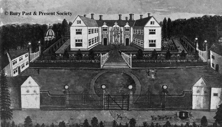
Developed on the site of an earlier moated manor house, Sir Robert Drury’s mansion was based on a quadrilateral plan with an inner courtyard built within the existing moat. It was further altered and improved by his grandson, Sir William Drury, after he was granted permission to crenulate. Although the main entrance was from the south, surviving brick evidence suggests there was a subsidiary entrance on the north side, although of a later date. A bridge crossed the moat and led through the south range to enter the inner courtyard where there was an immediate view of the two porches on either side of a huge Statue of Hercules (Grade II), also known as the ‘Wild Man’. This was created for William Drury for the visit of Elizabeth I in 1578. In 1784 the Revd Sir John Cullum in his The History and Antiquities of Hawstead in the County of Suffolk wrote that it served as a fountain, fed through pipes ‘from a pond near half a mile away off’, which refers to one of the large ponds to the north of the house. He also remarked that pyracantha once covered the walls of the house.
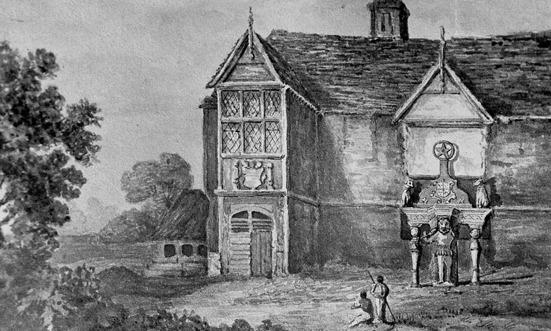
A map dated 1615 of Hawstead Place and copied in 1839 by John Gage in his The History and Antiquities of Suffolk: Thingoe Hundred was drawn soon after Sir Robert Drury left Hawstead to live at his neighbouring property of Hardwick. It shows the mansion as U-shaped, having lost its southern range, although the Suffolk Historic Environment Record states that all four sides of the building are believed to have been standing when the family left Hawstead for Hardwick in the 1730s. When Hawstead Place became a farm, the mansion building gradually reduced in size. An image from the 1780s shows it still U-shaped and without crenulation. In his history of Hawstead, the Revd Sir John Cullum suggests that only the north range survived. Around the same time a Jacobean painted closet at Hawstead was moved to Hardwick. In 1924 it was eventually sold to Christchurch Mansion in Ipswich at the time of an auction of Hardwick contents. During the 1820s a porch and the Statue of Hercules were also moved to Hardwick and the remains of the mansion at Hawstead were finally demolished in 1827. The statue was restored and returned to Hawstead Place in the 1970s.
HAWSTEAD PARK AND GARDEN
The 1615 map shows the moated mansion surrounded to the east, north and west by Great and Little Parks and areas of ‘Laune’. Parks of this period were primarily for deer hunting and were usually quite densely wooded, producing wood products and timber. At Hawstead, oak, ash and maple were the predominant species. Launes (or Launds) were more open areas and often closer to the house – as is the case for the area on the map just north of the moated mansion – and would have had ancient trees and be grazed by livestock and deer. They were managed for both aesthetic and hunting purposes. The park is said to have included a rabbit warren. In 1784 Revd Sir John Cullum wrote that the mansion originally had fine views of ‘lime, sycamore, poplar, broad and narrow-leaved elm, beech, walnut-tree, Scotch and spruce fir, oriental and occidental plane trees’, remarking that the oriental planes thrived with ‘three of them on a rather dry spot a little South of The Place’, these trees surviving to the present day. Also shown on the map is a series of ponds passing through ‘Great Parke’ running down the gentle slope of a tributary of the River Lark. Another series of smaller ponds to the south were said to serve as stew ponds at the time, although not shown on the map.
Disparkment began when the Cullums left Hawstead for Hardwick c. 1733–41. The c. 1780 image shows parkland with deer grazing south of the entrance, a lone horseman and carriage on the drive. The perspective of the parkland is foreshortened and shown bounded by a mixed hedgerow with a gate that would have given access to the River Lark. The main areas of Great and Little Parks were converted for agricultural purposes leaving parkland to the north, east and south of the moated site that are shown on a map dated 1812. Today only a small area of parkland is maintained around the farm, south-west of the moat and surrounding the ponds.
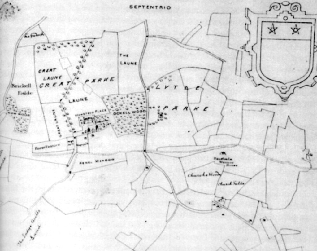
The house was originally approached through an outer courtyard (base court) on its south side with steps up to a wide raised terrace and bridge over the brick-lined moat giving access to the southern range of the mansion. By 1615 the mansion’s southern range had gone and the outer courtyard had two towers on either side of its southern entrance. Remains of the springing for the bridge and part of the brick-lined moat survive. Correspondence from Sir Dudley Cullum, to his friend John Evelyn c. 1694 appears to include an account of the site stating that ‘the banks of the moat were planted with yews and variegated hollies, and at a little distance, surrounded by a terrace that commands a fine woodland prospect. Here were orchards and gardens in abundance and a bowling yard, as it was called which was always used to be esteemed a necessary appendage of a gentleman’s seat’. At this time Hawstead Place was still Sir Dudley Cullum’s main residence, although the period between 1680 and 1720 saw him lay out the pleasure grounds of the Cullum’s other property of Hardwick House with the help of John Evelyn. The design of the gardens of his home at Hawstead must also have been in the fashionable manner of the period, with the opportunity to create formal gardens near the house and make the most of the existing ponds to create water gardens, particularly as Hardwick had few natural water features on its site so offered less opportunity to develop them.
In 1784 the Revd Sir John Cullum describes the raised terrace around the mansion as ‘commanding a fine view of the surrounding country’, with the east range of the house having a cloister to the east with views into a flower garden within the moat, large wild cherry trees in a hedgerow near the house and apple orchards and medicinal plants forming a ‘gay robe’. He added that a pigeon house, three gardens and two courtyards from the Drury period survived at the time. The c. 1780 image of the house shows this raised viewing terrace formally planted with conical trees surrounding the moat, the courtyard to the south with circular drive and lawns. By this time the courtyard’s south side had wrought-iron fencing with brick piers topped by limestone balls and central gate through which the southern drive from Pinfold Green entered. The Revd Sir John describes this outer courtyard as c. 202ft x 211ft (61.5m x 64.3m) with sides of barns, stables, a mill house, slaughter house, blacksmiths shop and various other offices. To the west of the house there was an octagonal banqueting house, similar to that at Melford Hall, which Cullum described as adjoining a glasshouse next to the moat, with a square ‘festive apartment’ for anglers over the moat. The farmhouse is shown on the west side of the outer courtyard and a stable block with clock tower on the east side. Today the moated site is covered with trees and vegetation, with some areas still lined with Tudor bricks. The substantial flat-topped outer banks survive on the north and east sides with brick revetting at the corners, as does the entrance to the south with evidence of a subsidiary entrance to the north, indicated by a brick-lined gap for a drawbridge possibly introduced in the eighteenth century.
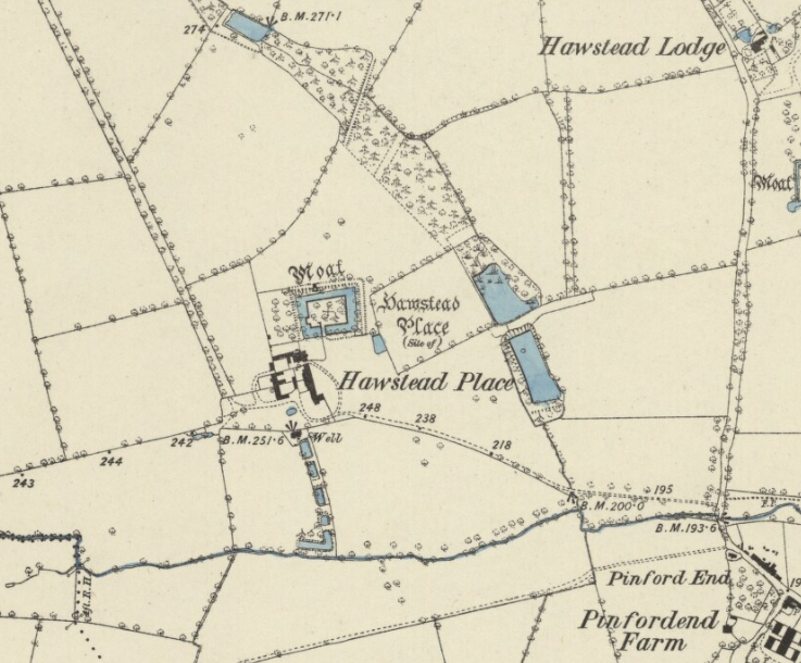
A map showing more detail dated 1812 depicts the moated mansion with the outer courtyard formed by buildings to east and west and fenced boundary with the southern parkland area. It also shows a surviving brick lined L-shaped pond that springs off the south-east corner of the moat. Beyond was an area of garden with large rectangular pond, one of the series down the gently sloping valley. This had two inlets, possibly boat landing points, and was backed by a belt of trees that would have been seen from the raised terrace surrounding the moat. Just south there was another pond with L-shaped belt of trees to the west, creating a more private area screened from view from the farm with views to the east overlooking parkland. Within an enclosure to the west of the moat there was an orchard and the drive from the south-east was partly tree-lined, its route taking it to the farmyard rather than centrally accessing the moated house remains.
Surveyed in 1838 the map associated with the 1842 tithe apportionment shows the moated site without the mansion. The farmhouse and farm buildings were then linked to the moat by a straight path. Attached to the west side of the moat was a surviving walled enclosure divided into two. The larger northern section was now an orchard and the smaller southern section attached to the farmhouse a garden that probably provided both produce and flowers. Surrounding the moated site, various fields are named ‘Park’, such as ‘Great Park Field’ and ‘Little Park Field’ to the north-west and ‘Ploughed Park’ due east. These had been disparked and were now cultivated. Names suggesting areas that continued to be managed as parkland were further south such as ‘Middle Park’, ‘Lower Park’ and, straddling the south-east drive ‘Home Park’ and ‘Walnut-tree Park’. Evidence for a dovehouse was indicated by a field south-west of the farmyard called ‘Dove House Close, part of’ and to its east the southern L-shaped pond in the series of smaller ponds was surrounded by trees that were named ‘Dovehouse Close Plantation’. Clearly shown on the tithe map and suggesting their visual importance are the series of smaller ponds, these possibly retained some water garden features from the earlier period. The area to the east of the moated site was shown as an orchard. Where once there were large ponds to the north and east, woods were now shown through which the tributary of the River Lark flowed. This must have made them waterlogged plantations ideal for duck shooting. Later the most northern pond was sold, while the Cullum family retained the others for their own use. During the twentieth century two of the larger ponds were turned into coarse fishing lakes.
Little changed over the following forty years. The 1884 OS map still clearly marks the five smaller ponds, which at the time had a well, viewing point symbol at their head and small building, perhaps a summerhouse from which there would have been views down the valley side to the River Lark. Today there are only four ponds, the northern having been in-filled. More recently there has been some clearing, dam repair and rescarping of the others.
HAWSTEAD PLACE AND FARM BUILDINGS
Today’s Hawstead Place Farmhouse is mainly of a mid-nineteenth century date but has a much earlier core from the sixteenth and seventeenth centuries. Surviving buildings of the farmstead include a barn with crown-post roof dating back to 1423 (Grade II) that is the earliest known single-aisled barn in Suffolk and, like the farmhouse, formed part of the west side of the outer courtyard to the south of the demolished mansion. It was recently restored to be used for weddings and events. Other surviving farmyard buildings include a barn dated to the early-seventeenth century (Grade II) and granary cartshed (Grade II) which was built in the late-eighteenth or early nineteenth century, although with reused timbers from a sixteenth-century structure that has been converted as holiday accommodation.
WALLED GARDEN ENCLOSURE
The walled garden enclosure west of the moat dates to the sixteenth century and was probably built for Sir William Drury. Early maps show it to have been an orchard. Measuring c. 70m x 40m (300ft x 131ft) the red brick walls are c. 3m (10ft) high topped by elaborate moulded clay copings, strengthened with a number of concrete buttresses in the twentieth century. Although shown as one compartment on the tithe map, it is now divided into two sections by a red brick wall of various heights, the lower portion probably dating back to the Drury period and the top c. 1.2m (4ft) likely to be nineteenth century. The southern enclosure is the smaller of the two and has two surviving gateways. The eastern gateway led directly into the outer courtyard south of the mansion, although its opening is now bricked-up. The other along the west wall would have led out into the park. This was probably inserted c. 1675 for Sir Thomas Cullum and has a pair of gate piers 4m (13ft) high with niches at a low level. The piers are surmounted by limestone cornices, cupola and ball finial. The eastern entrance is similar, although of a plainer design. The 1905 OS map shows the walled enclosure to be slightly irregular in shape with a lean-to glasshouse attached to the dividing wall that was lost during the twentieth century. Sales particulars of 1924 describe the farm as having ‘A large kitchen garden and orchard with a considerable portion of old garden wall…’. Today a modern house stands in the northern compartment with a new access from the west and now mainly has a formal garden with a few surviving early espaliered trees. The southern compartment now serves as the garden for the farmhouse.
SOURCES:
Barr, Elaine, George Wickes 1698–1761, Royal Goldsmith, 1980.
Copinger, W. A., The Manors of Suffolk, Vol. 5, 1904.
Cliffe, John, Trevor, The World of the Country House in Seventeenth-Century England, 1999.
Cullum, Revd Sir John, The History and Antiquities of Hawstead in the County of Suffolk, 1784.
Evelyn, John, Diary and Correspondence of John Evelyn, Vol. 3, 1643–1704.
Gage, John, The History and Antiquities of Suffolk, Thingoe Hundred, 1839.
Hoppitt, Rosemary, Deer Parks of Suffolk 1086–1602, 2020.
Pevsner, Nikolaus and Radcliffe, Enid, The Buildings of England: Suffolk, 1975.
Redstone, Lilian, ‘Hardwick House, Bury St. Edmunds’ in Suffolk Institute of Archaeology and History, Vol XIV, Part 2, 1911.
Roberts, W. M., Lost Country Houses of Suffolk, 2010.
Suffolk Institute of Archaeology and History, Excursions, Vol XXXVII Part 3, 1991.
Suffolk Gardens Trust, Walled Kitchen Gardens Recording Group, Broster, Jenny, Suffolk Gardens Trust Walled Gardens Group Report of Hawstead Park Farm, 2015 (unpublished document).
Williamson, Tom, Suffolk’s Gardens and Parks, 2000.
White, William, Directory of Suffolk, 1855.
http://www.stedmundsburychronicle.co.uk/Chronicle/.htm (accessed October 2021).
https://suffolkbarn.co.uk/suffolk-barn/ (accessed October 2021).
www.burypastandpresent.org.uk, Bury St Edmunds Past & Present Society, (accessed October 2021).
Census: 1861, 1871, 1881, 1901, 1911.
1783 Hodskinson’s Map of Suffolk in 1783.
1842 (surveyed 1838) tithe map and apportionment.
1884 (surveyed 1884) OS map.
1905 (revised 1903) OS map.
1952 (revised 1950) OS map.
2023 Google aerial map (Imagery © Bluesky, CNES / Airbus, Getmapping plc, Infoterra Lts & Bluesky, Maxar Technologies, Map data © 2023).
Heritage Assets:
Suffolk Historic Environment Record (SHER): HWS 001, HWS 007, HWS 008, HWS 021, HWS 030.
All Saints Church (Grade I), Historic England No. 1279106.
Hawstead Place Farmhouse (Grade II), Historic England No. 1279037.
Walling and Two Gateways 20 metres north west of Place Farmhouse (Grade II), Historic England No. 1279036.
Statue of Hercules 30 metres north-west of Place Farmhouse (Grade II), Historic England No. 1229508.
Barn 30 metres south of Place Farmhouse (Grade II), Historic England No. 1229509.
Barn 60 metres south of Place Farmhouse (Grade II), Historic England No. 1229510.
Granary Cartshed 60 metres south-west of Place Farmhouse (Grade II), Historic England No. 1229633.
Historic England Research Records, HobUiD: 382259, NGR: TL 84260 59970.
Suffolk Archives (previously Suffolk Records Office):
(SA) The Cullum Library.
(SA) E2/12/4 Plans of the Hardwick Estate… No. 3 Hawstead Place Farm drawn by R. Payne, Surveyor, 1812.
(SA) HD1643/4/50, Manuscript notes on the history of Hawstead including Hawstead Place and Hawstead Place Farm, maps with fields, 1615–.
(SA) HD526/63/7/2, Photographs of Hawstead Place.
(SA) HD526/63, papers of the Reverend Edmund Farrer, (1615)–1930.
Site ownership: Private
Study written: October 2023
Type of Study: Desktop
Written by: Tina Ranft
Amended:
