(also known as Great Bealings House)
Parish: GREAT BEALINGS
District Council: EAST SUFFOLK (previously Suffolk Coastal)
TM 242 488
Not open to the public
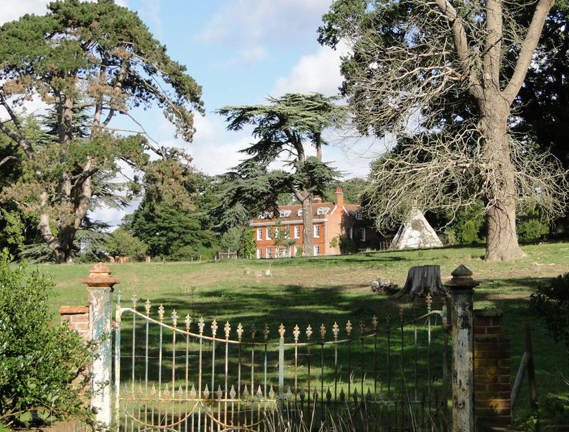
To the east of Great Bealings village and c. 3.2km (2mls) west of Woodbridge, Bealings House (Grade II) lies on rising ground overlooking the valley of the River Lark close to where it joins the River Fynn as their waters make their way to Martlesham Creek before joining the River Deben. Although not shown on Hodskinson’s map of 1783, the red brick house was built c. 1777 to a classically symmetrical design with central entrance door to the south-facing front and rear courtyard set between two projecting wings.
Believed to have once been the residence of the controversial clergyman the Revd Evanson, it was occupied by Admiral Sir Joshua Rowley at about the time Major Edward Moor bought the Bealings House Estate on his retirement from the army in 1806. Edward is said to have been a stout old man who wore a hat ‘several sizes too big’ and ‘carried a cane cut from the timber of HMS Royal George’, useful for his strolls such as that recorded in June 1823 by Davy in his Journal of Excursions in the County of Suffolk when they walked from Bealings House to the church in the village. Edward was also a family friend of Edward Fitzgerald, the poet, philosopher and best known for his translation of The Rubaiyat of Omar Khayyam. A Fellow of the Royal Society and author on Indian mythology, Edward is said to have witnessed a paranormal bell ringing episode at the house in 1834. After Edward’s death in 1848 the house stayed in the ownership of the Moor family and was leased, often by those with military connections such as the last tenant General Sir Richard Thomas Farren who retired from the army in 1883. By 1891, he and his younger wife Agnes were living at Bealings House with their two young children. Sir Richard died in 1909 and ten years later the Bealings House Estate of 100ha (250a) was put up for sale by Major E. C. Moor, including c. 12ha (30a) of parkland, stabling and gardens. Described as a residential, agricultural and sporting estate of 271ha (670a) the estate was again for sale in the 1930s, altered tithe apportionments suggest it was bought by a Mrs M. G. Jones. The estate began to be broken up and Rosery Farm and 64ha (158a) to the south of Bealings House was for sale as a separate lot in 1949. Bealings House continues to stay in private ownership.
The tithe map surveyed in 1838 and attached to the 1839 tithe apportionment shows the estate extending south to the River Lark and included farms, agricultural fields and meadows. The U-shaped house with barn and stabling to the rear lay in a small park to the south and east dotted with coniferous and deciduous freestanding trees, with an orchard beyond the barn to the north. Arable fields to the north of Bealings House formed part of the estate. These were called ‘Clay Pitts’ on the tithe apportionment suggesting their historic use and perhaps where the clay came from to make bricks used in building the house. A shelterbelt of trees gave privacy from Birds Hill, the road to the east. The road to the south is referred to as ‘a new road at the front of Bealings House at the bottom of Birds Hill’ in a Highways Diversion Order dated 1807, a year after Major Edward Moor bought the estate. On the opposite side of this road there was a farm, small plantation and an area dotted with deciduous trees referred to on the apportionment as ‘pastureland’, often another term for parkland, and would have appeared as such from the house to extend the vista down towards the river. The main south-east entrance drive from Birds Hill led up to a turning circle in front of the house and a further drive from the south led to both house and stables to the rear. Added by Edward Moor, probably soon after he bought the estate, a surviving garden folly (Grade II) in the form of a c. 3m (10ft) high pyramid of knapped flint and mixed rubble with ashlar dressings, was built c. 90m (300ft) to the south-east of the house close to the drive. This incorporates figures of Shiva and Brahma, Indian deities that are said to have been found by Edward in Bombay and may be from the eleventh century. The drives cut through a curvilinear line denoting a terrace around the house that would have enhanced the natural slope of the site. This enclosed a small area of gardens around the house.
With the exception of the expansion of the parkland taking in an arable field to the west and the addition of trees lining the south drive by 1884, there were no further changes over the next century and a half to the layout of the parkland and simple gardens of lawns interspersed with trees and shrubs.
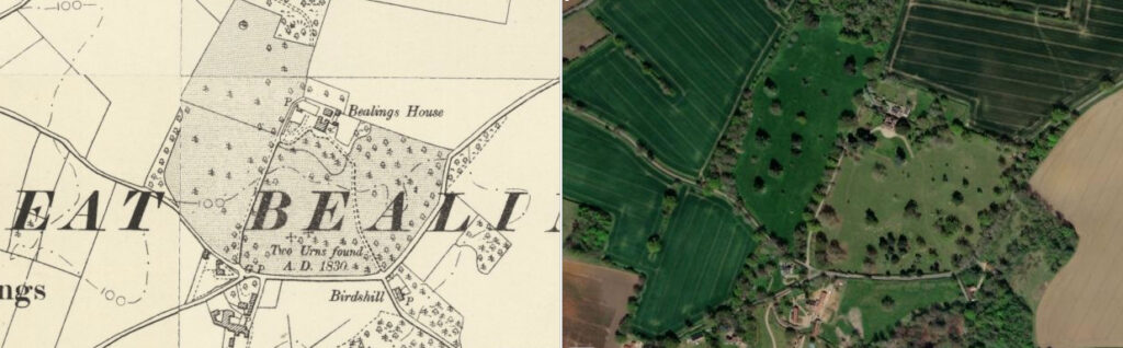
Today the parkland extends to an area much as it was by 1884. A number of parkland trees, notably oak, Scots pine and cedars, survive that are believed to have been planted early in the nineteenth century, probably by Major Moor when he bought the property. Only the south drive now serves the house, the south-east entrance today marked by an unused nineteenth century gateway with uninterrupted parkland beyond, the old drive only visible by cropmarks from the air. The curvilinear terrace survives as an earthwork enclosing what remains of the south-east drive and the gardens have been extended by the addition of part of the field to the north of the house.
SOURCES:
Birch, Mel, Suffolk’s Ancient Sites Historic Places, 2004.
Davy, David, Elisha, A Journal of Excursions through the County of Suffolk 1823-1844, published by Suffolk Records Society, 1982.
(Combined parish councils) Great Bealings, Little Bealings and Playford Parish Plan, April 2009.
Great Bealings Parish Council, Great Bealings Neighbourhood Plan, March 2016.
Kelly’s Directory of Suffolk, 1896.
White, William, Directory of Suffolk, 1844, 1855.
Wayland, M. J., ‘The Paranormal Bell-Ringing of Bealings House, Suffolk’, 13 July 2012. https://www.spookyisles.com/the-bells-of-bealings-house/ (accessed November 2023).
Briggs, Stacia and Connor, Siofra, Weird Suffolk: ‘Poltergeist activity at Great Bealings’, 1 February 2019, East Anglian Daily Times. https://www.eadt.co.uk/news/21445662.weird-suffolk-poltergeist-activity-great-bealings/ (accessed November 2023).
Adrian S. Pye. Commentary from photographer regarding conversation with owner, https://www.geograph.org.uk/photo/5913751 (accessed November 2019).
Census: 1851, 1881, 1891, 1901, 1911.
Hodskinson’s Map of Suffolk in 1783.
1839 (tithe map 1838) and apportionment.
1884 (surveyed 1881) Ordnance Survey map.
1905 (revised 1902) OS map.
2023 Google aerial map (Imagery © Bluesky, CNES / Airbus, Getmapping plc, Infoterra Lts & Bluesky, Maxar Technologies, Map data © 2022).
Heritage Assets:
Suffolk Historic Environment Record (SHER): BEG 004, BEG 049.
Bealings House (Grade II). Historic England No: 1284017.
Garden Ornament circa 100 yards east south east of Bealings House (Grade II). Historic England No: 1030754.
English Heritage Project Ref: 3987, The Aggregate Landscape of Suffolk: The Archaeological Resource, Interim report for Aerial Survey component Areas One & Two: The Felixstowe Peninsula, PDF version 2011.
Suffolk Record Office (now Suffolk Archives):
SRO (Ipswich) HD 4084/221. Brief pedigree of Major Edward Moor of Bealings House, 1771–1848.
SRO (Ipswich) B/106/5/117. Highway Diversion Order for Great Bealings, 1807.
SRO (Ipswich) HD 2833/2/SC034/1. Particulars and conditions of sale of residential property known as Great Bealings House, 29 July 1919.
SRO (Ipswich) HE 402/2/1919/20, Sales Particulars, 1919.
SRO (Ipswich) HD 2833/1/SC034/12. Sales Particulars, c. 1930.
SRO (Ipswich) HD 2833/1/SC034/9. Sales Particulars for parts of Great Bealings House Estate, Great Bealings, 20 September 1949.
Site ownership: Private
Study written: November 2023
Type of Study: Desktop
Written by: Tina Ranft
Amended:
