(demolished 1926)
Parish: BARKING
District Council: MID SUFFOLK
TM 075 534
Not open to the general public
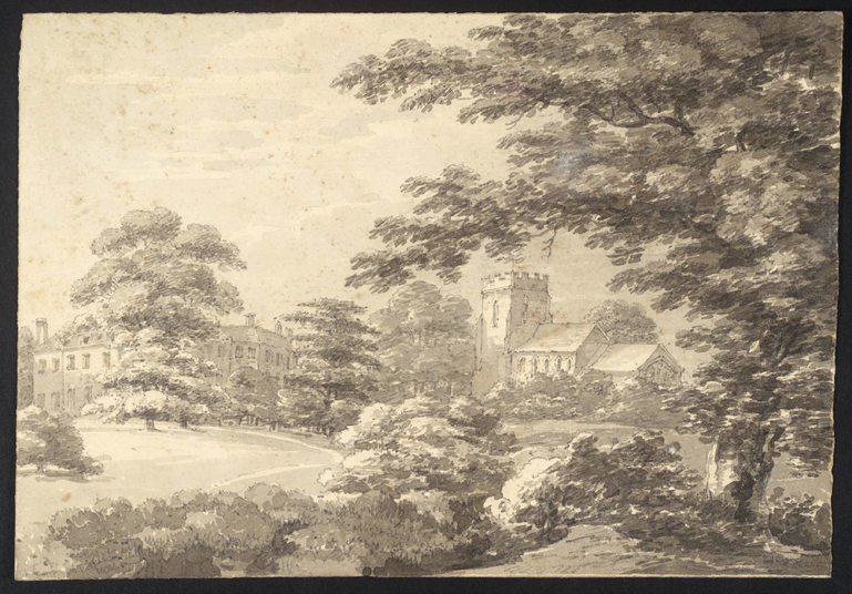
Standing next to parish Church of St Mary (Grade I), the demolished early-eighteenth century Barking Hall lay on an elevated site overlooking a tributary of the River Gipping that flows eastward to join the Gipping just south of Needham Market c. 2.5km (1.5mls) away. To the east of the Hall site lies Park Wood, which is believed to be the extent of a very small medieval deer park referred to in 1251 that survives as a wood today. On the opposite side of the small valley are a series of ancient woods, such as Priestly, Swingens and Bonny Woods that formed part of the Barking Hall Estate. The house was demolished in 1926 leaving the stable block that has been substantially extended to become a care home and the remains of a large walled garden.
THE HALL AND IT’S OWNERS
The manor of Barking (Barking-cum-Needham) was owned by the Bishop of Ely during the late-medieval period. It was seized by the crown in 1562/3 and then sold to Sir Francis Needham and John Yeomans in the early 1600s. Later bought by Sir Francis Theobald, it eventually passed to his daughter Anne, wife of the Revd Joseph Gascoyne, vicar of Enfield in Middlesex. The Barking Hall Estate passed to their son Theobald Gascoigne and on his death in 1714 to his sister Theodosia. Barking Hall was built next to the parish church around this time, replacing the Theobald’s former manor house that is recorded as a large and significant building with twenty-hearths in 1674. Part of the former house is believed to have been incorporated into the new early-eighteenth century Barking Hall as its service wing. It has been suggested that this wing may have remained a separate block from the main house throughout its history.
Wealthy in her own right, Theodosia married John Crowley Esq. whose family had become extremely rich as merchants and makers of various merchandize, chiefly iron wares. The Crowleys mainly lived at Greenwich and London, keeping Barking Hall as their Suffolk base to enjoy country pursuits, principally hunting in the estate’s woods. John Crowley died in 1728, leaving Theodosia a wealthy widow. The family extended the estate by buying various parcels of land in Barking, Hitcham and Buxhall. They also went on to buy nearby Combs Hall, Badley Hall and Columbine Hall in Stowupland. A monument in the church speaks of Theodosia’s virtuous, generous and kind disposition during her long life after her death in 1782 at the age of eighty-nine. Ownership of the estates appears to have passed to Theodosia’s eldest son Ambrose many years before her death. Ambrose died unmarried in 1754, followed a year later by the death of her other unmarried son John, both in their thirties.
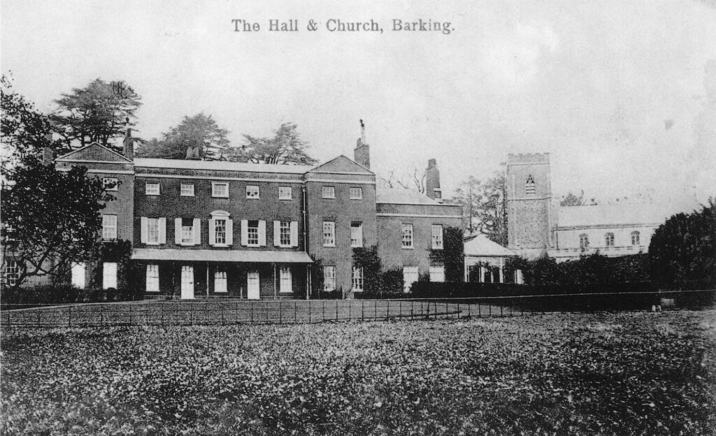
The estates jointly passed to the husbands of two of Theodosia’s four daughters, Elizabeth who married John Earl of Ashburnham and another daughter who was married to Charles Boone (Bone) Esq. of Lee in Kent. Eventually the whole extensive estate passed into the hands of the Ashburnham family. They owned Barking until the death of the 5th Earl in 1913, although for much of the time the house was sub-divided and let out to tenants. It was subsequently sold to a syndicate of locals and then the estate of 1,396ha (3,450a) was for sale again in lots in 1917. The lot comprising house, stables, walled garden and c. 16ha (40a) of gardens and parkland failed to sell at auction, although it sold privately afterwards. In April 1926 the house was sold for demolition, although the stables survived to be used as a poultry house and cottage for a smallholder who cultivated the walled kitchen garden. It later became a livery with stables and home to the owner before finally enlarged with landscaping to become a care home, as it remains today.
THE PARK AND GARDEN
Leases issued by the Bishop of Ely dated 1517 and 1541 list the extent of the Barking Hall Estate, which included the ancient woods, meadows, pastures, commons, heaths, houses, orchards, barns, stables and a dovecot, although the dovecote site is unknown. A detailed inventory dated 1611 does not mention a park, but when the crown sold the manor of Barking to Sir Francis Needham he was given the right to empark no more than c. 162ha (400a) for deer and other beasts. This may suggest that the documented small thirteenth century deer park of Park Wood had survived throughout the later medieval period and Sir Francis was given the right to add to it by incorporating the ancient woodlands within the estate. However, it is also possible that the earlier park had been disparked and a larger one newly-created after 1611.
Barking Hall is named on Kirby’s 1736 map as the seat of the Earl of Ashburnham and shown next to the church. A survey of the estates of the Earl of Ashburnham and Charles Boone dated 1772 shows the remains of avenues centred on the mansion running across pasture. Wide rides cut through the surrounding woods, which were probably originally part of a complex of late-seventeenth century avenues, not unlike the avenues at nearby Badley Hall and Combs Hall. In 1783 Hodskinson names Charles Boone as resident on his map of Suffolk.
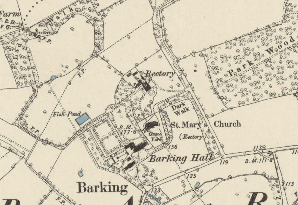
Over a century later, the 1884 OS map shows access to the site from the south with a drive branching off to a roughly circular forecourt in front of the house and the other branch to the stable block, rear service wing and large surviving rectangular walled garden. Given the early history of the site, this garden may have been built at the same time as the new mansion in the early-eighteenth century, perhaps on the footprint of walled enclosures surrounding the original sixteenth or early-seventeenth century mansion. The walled kitchen garden had an entrance from the yard behind the stables and also one through its east wall from the main gardens to the rear of the Hall. Inside there was a tree-lined perimeter path with cross-paths dividing the garden into two.
The kitchen garden was surrounded on three sides by slip gardens with paths leading out to the north and west towards and through a crescent-shaped wood known as Ladies Walk, a circular walk of c. 1.6km (1ml). Having lost most of its eastern section during the twentieth century, the remains of the wood survives today. Within it are a large mound and earthwork enclosure bank that has been suggested as a prospect or viewing mound. An alternate interpretation is that it was a pillow mound associated with the warrening of rabbits. Just north-west of the walled garden and beside one of the paths there was a small rectangular pond that also survives today. Obviously a source of water for the garden, it seems likely to have been treated as an ornamental feature to admire whilst taking a constitutional walk towards Ladies Walk.
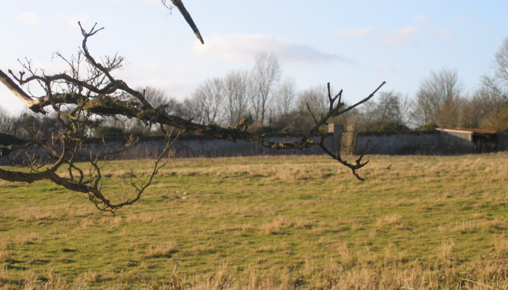
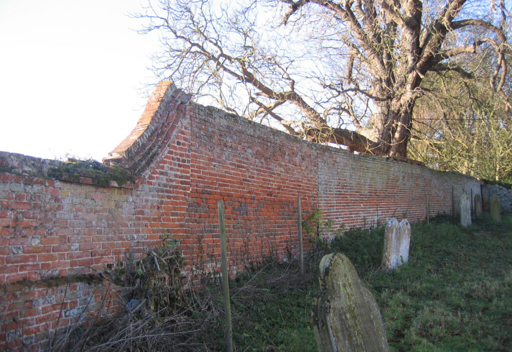
To the rear of the house there was a large lawn with circular path beside borders of coniferous and deciduous trees, some surviving today, which joined the other paths. The lawned area was enclosed on the west by one wall of the walled garden and on the east by a tall surviving brick wall that acts as the boundary between the mansion’s gardens and the church and gardens of the rectory to the north, now known as The Old Rectory (Grade II) and built at the beginning of the nineteenth century. This lawned area behind Barking Hall must be where fashionable formal gardens associated with the earlier mansion once stood. However, archaeological excavations conducted before the care home was extended c. 2005 only showed evidence for the remains of gardens dating to the nineteenth century.
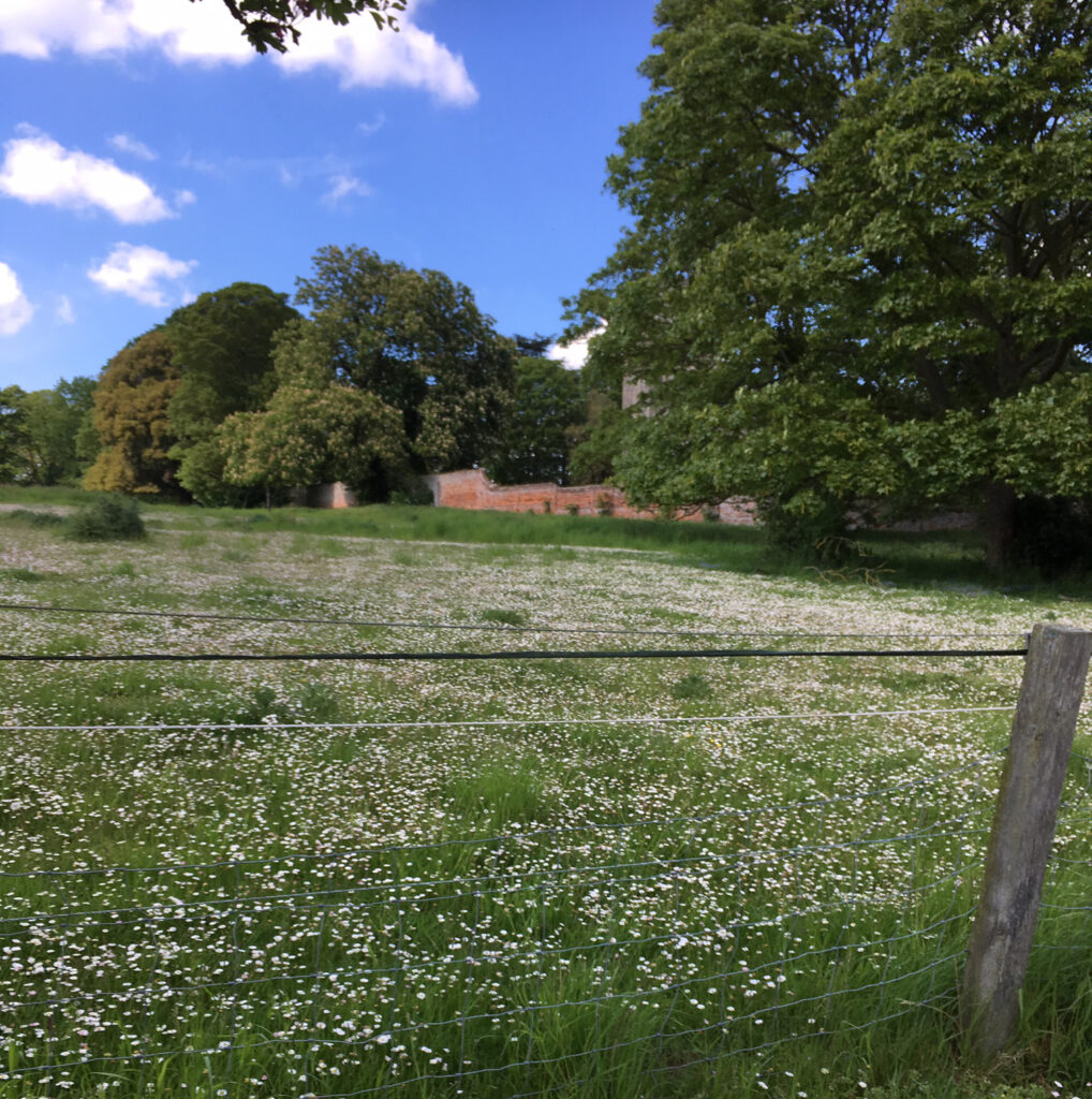
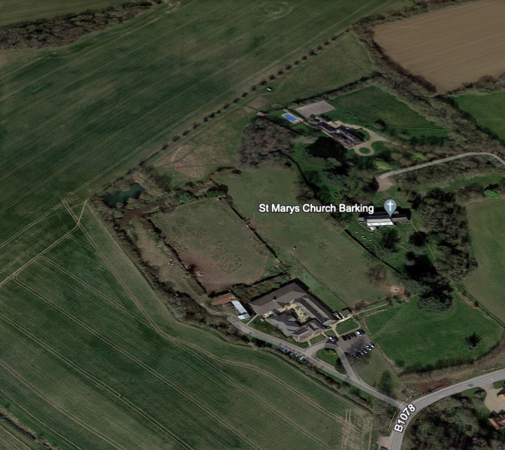
There was little change in the park and gardens of Barking Hall over the following years and today what remains are the uncultivated and overgrown walled garden that is believed to be in separate ownership from the care home, an area of wild meadow behind the site of the demolished Hall where the gardens once stood and a small area of park-like lawn to the front of the care home, which now has a line of coniferous trees that were planted in the twentieth century to shield the care home from the road. Mature freestanding trees, many planted during the nineteenth century, survive near the boundary between the churchyard and The Old Rectory gardens.
SOURCES:
Barker, H. R., East Suffolk Illustrated, 1908.
Copinger, W. A., The History of the Manors of Suffolk, Vol. 2, 1908.
Hoppitt, Rosemary, Deer Parks of Suffolk 1086–1602, 2020.
Martin, Edward and Oswald, Alastair, ‘The House and Gardens of Combs Hall, Near Stowmarket: A Survey by the Royal Commission on the Historical Monuments of England’ in Suffolk Institute of Archaeology and History, Vol. XXXV111, Part 4, 1996.
Roberts, W. M., Lost Country Houses of Suffolk, 2010.
Vane, J., The Manor and Woodlands of Barking, 1990.
Williamson, Tom, Suffolk’s Gardens & Parks, 2000.
Maps:
1783 Hodskinson’s Map of Suffolk in 1783.
1884 (surveyed 1884) Ordnance Survey map.
1905 (revised 1902) OS map.
2023 Google aerial map (Imagery © Bluesky, CNES / Airbus, Getmapping plc, Infoterra Lts & Bluesky, Maxar Technologies, Map data © 2023).
Heritage Assets:
Suffolk Historic Environment Record (SHER): BRK 107, BRK 015, BRK 018, BRK 093, BRK 122, BRK Misc.
Church of St Mary (Grade I), Historic England No: 1231756.
The Old Rectory (Grade II). Historic England No: 1277413.
Suffolk Archives (previously Suffolk Record Office):
(SA) HA1. Ashburnham Archive (Suffolk Estates).
(SA) HD78/2671. South-facing front of Barking Hall, undated photograph.
(SA) HA1/HB4/1. Ashburnham Archive (Suffolk Estates). Survey of estates of the Earl of Ashburnham and Charles Bone (Boone), 1771.
(SA) HA1/HB5/1/3. Plan of Barking Hall by E. and G. N. Driver, Whitehall, 1832.
(SA) HE402/2/1917/6. Woodward & Woodward, Sale Particulars, 11 December 1917.
Site ownership: Private
Study written: December 2023
Type of Study: Desktop/visits 2012, 2019.
Written by: Tina Ranft
Amended:
