Parish: MELTON
District Council: EAST SUFFOLK (previously Suffolk Coastal)
TM 280 503
Not open to the public
The Regency Melton Hall (Grade II) stands near the site of an earlier Tudor manor house that is believed to have been built by Richard Wood, youngest son of the Earl of Halifax. The original house is shown on Hodskinson’s 1783 map but un-named. The site is c. 1.5km (1ml) north of the centre of Woodbridge and beside the historic main road from London to Yarmouth, which runs northward approximately along the junction between Suffolk’s clayland plateau and an area of prominently sandy soils called The Sandlings. The original Melton Hall Estate appears to have included woods and farmland to the west, south and north.
During the eighteenth century Richard Wood’s great-grandson, Francis Wood, set up a solicitor’s practice that was continued by successive family members into the twentieth century in Woodbridge. It is thought the original house burnt down and a new house was built at the end of the eighteenth century at the junction of the London to Yarmouth road and a road running east to west, now known as Woods Lane, by John Wood who moved into the new house with his family in 1807, having previously lived in Woodbridge. An 1831 estate map shows a coach house and walled kitchen garden with crinkle-crankle dividing walls beside the east–west road, likely to have been built at the same time as the new house. The farmhouse to the south, now called Melton Mead (Grade II), is said to have been altered to become the dower house with the farm relocated further north, close to what is now known as Hall Farm Road. By the time of the tithe apportionment in 1837 ownership of the dower house, and with it the small area of parkland to the south, had passed to Matilda Buckingham and John Haywood, with John making it his home. Matilda also owned and rented out the Coach and Horses coaching inn on the opposite side of the road that continues to trade today. The tithe map shows Melton Hall facing east with a curving in-and-out drive off the main road with surrounding small area of gardens. Further west was an area of pasture called ‘The Lawn’ and beyond was ‘Sand pit pasture’ and a shelterbelt of trees surrounding it to the north and west giving privacy from the road and neighbouring property.
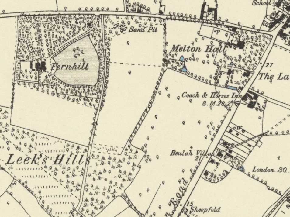
By 1881, when the survey was carried out for the 1887 OS map, the original dower house had been renamed ‘The Lawn’. It included a square garden enclosure with small rectangular pond forming its southern boundary and further small enclosure to the west that were presumably created from the original farmyard. Melton Hall retained its in-and-out drive that was surrounded by a mixed planting of trees with a lawn to the south of the house. To the rear is the walled garden enclosure and to the west and south were two separate, small areas of parkland dotted with trees and edged by boundary trees. That nearest the house to the west had a copse of trees in its south-west corner that survives today, with two ponds and a small building, possibly a summerhouse, marked on the map.
The solicitors practise continued until the 1930s with the Melton Hall Estate staying in the Wood family until 1936 when it was put up for sale in separate lots. Sales particulars list the house in 1.6ha (4a) with ‘Two Tennis Lawns, Formal Gardens, Walled Kitchen Garden, Stabling for 4 and other Outbuildings’. The rest of the 37ha (92a) of estate was sold in lots as ‘Valuable Building Land’. Maude and Monty Wace bought the house with 6.88ha (17a), the 1949 OS map suggesting this may have included the southern area of parkland once attached to Melton Mead. Its ownership was eventually transferred to Melton Parish Council and the Melton Playing Field was opened in 1952.
Melton Hall changed hands a number of times during the second half of the twentieth century, during which time a house was built in westernmost section of the walled garden and the coach house was altered and converted for residential use. A small part of the garden to the north of the house was lost when a new relief road was built connecting the village of Melton to the new route of the A12 in 1980s and a new tall boundary wall of handmade bricks was built along its length. From the 1990s and into the twenty-first century the house was run as a luxury B&B.
In 2022 Melton Hall standing in 3ha (7.5a) was for sale. Sales particulars described the gardens as including a water garden, herbaceous and shrub beds, and retaining a number of mature nineteenth century native and ornamental trees, although many had been lost in the storm of 1987. There is also a wildlife meadow and wood that are now managed in collaboration with Suffolk Wildlife Trust. The walled garden is still divided by crinkle-crankle walls, with one section planted with a collection of roses and the other a kitchen garden with box-edged beds.
SOURCES:
de la Rue, Colin, ‘Melton Hall, the house, the grounds, and the people who live here’ in 25 Beautiful Homes, a Country Life production, October 2002.
Kelly, Post Office Directory of Cambridgeshire, Norfolk, and Suffolk, 1858, 1858, 1922, 1929.
White, William, History, Gazetteer, and Directory of Suffolk, 1844.
The Wood Family 2 in Melton in the 18th century http://www.barbsweb.co.uk/history/wood2.htm (accessed January 2018).
Melton Parish Council Recreation http://melton-suffolk-pc.gov.uk/recreation (accessed September 2023).
https://www.jackson-stops.co.uk/properties/15761877/sales/ipswich (accessed October 2022).
Census: 1851, 1861, 1871, 1881, 1891, 1901.
Hodskinson’s Map of Suffolk in 1783.
1837 (surveyed 1837) tithe map and apportionment.
1887 (surveyed 1881) Ordnance Survey map.
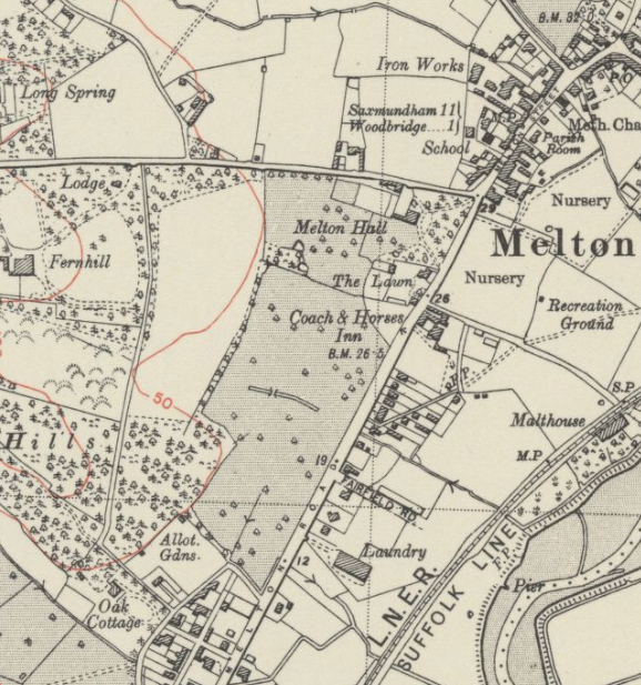
1905 (revised 1902 to 1903) OS map.
1928 (revised 1925) OS map.
1949 (revised 1938) OS map.
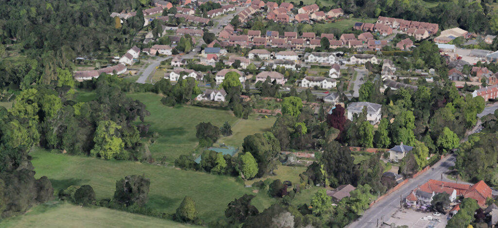
2023 Google aerial map (Imagery © Bluesky, CNES / Airbus, Getmapping plc, Infoterra Lts & Bluesky, Maxar Technologies, Map data © 2023).
Heritage Assets:
Melton Hall (Grade II), Historic England No: 1183391.
Melton Mead (Grade II), Historic England No: 1377359.
Suffolk Record Office (now Suffolk Archives):
SRO (Ipswich) IC/AA1/134/95, Original Will of Edmund Woods of Melton, 1704.
SRO (Ipswich) FE1/8/22, Probate Inventory for William Woods of Melton, 1712.
SRO (Ipswich) FC30/E/2/1, Lease: John Syer and Richard Wood, churchwardens of Melton for Melton Green Field for 11 years, 1796.
SRO (The Hold, Ipswich) FC25/H/1, Melton Toll Gate, 1823–1861.
SRO (The Hold, Ipswich) HD2833/1/SC281/5, Sales Particulars of Melton Hall Estate, 1936.
SRO (Ipswich) HG400/2/304/5/1, Contract drawing for alterations to Melton Hall, 1937.
SRO (The Hold, Ipswich) HG400/2/304/5, Contract drawings Melton Hall, Woodbridge for Col. M. Wace, 1937.
SRO (The Hold, Ipswich) HD2833/1/SC281/1, Particulars and conditions of sale of remaining portions of The Melton Farm and Melton Hall Estates, 1950.
SRO (The Hold, Ipswich) HD2833/1/SC281/20, Sales Particulars for Melton Hall with Coach House and Stable Flat, 1989.
Site ownership: Private
Study written: September 2023
Type of Study: Desktop
Written by: Tina Ranft
Amended:
