Parish: ASSINGTON
District Council: BABERGH
TL 935 389
Not open to the general public. Run as a Christian Centre only for bookings and events
In a rolling arable landscape of chalky clay soils c. 6.5km (4mls) south-east of Sudbury, the remains of sixteenth century Assington Hall lie close to a tributary stream of the River Stour that rises to the north and flows southward through the site. On higher ground on the east side of the valley, the Hall stands beside the Church of St Edmund (Grade I) in the remains of an eighteenth century landscape park. The site includes the remains of a moated island, possibly a garden dating to the sixteenth century, late-eighteenth or early-nineteenth century stables and coach house (Grade II) with the remains of an attached walled garden and remnants of eighteenth and nineteenth century pleasure gardens.
THE HALL AND ITS OWNERS
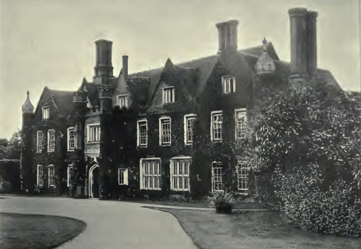
Robert Gurdon of Lavenham bought the manor of Assingtonand Assington Hall c. 1555. The house was the work of the Gurdon family, mainly during the sixteenth century, although there are suggestions that it may have earlier origins. The timber-framed house was arranged on three sides of a quadrangle, with the east-facing front elevation encased in red brick in the early-nineteenth century and a rear wing added later. The Gurdon family – also owners of Grundisburgh Hall near Woodbridge – were to remain at Assington until 1938 when the whole estate, including parkland, woodlands, farms and most of the village was for sale and subsequently broken up. The house survived until 1957 when it was gutted by fire during restoration work. Only the tall brick chimneys, entrance porch, minareted turrets and the front of one gable remain standing from the original building, with a later rear wing also surviving and today used as a private home. Into the twenty-first century the present owners have developed the site as a Christian Centre offering a peaceful, quiet space for reflection with workshops, camps, activities and events for small and large groups.
ASSINGTON PARK
The Assington Hall Estate once covered much of the parish including the ancient woodland of Assington Thicks, the possible remains of an early medieval deer park that stretched across the parish boundary to the west. Assington village was originally centred on the Hall and adjacent church, but to give the Gurdons more privacy, it was moved further south to allow the park to be extended and landscaped. This is thought to have taken place between 1778 and 1817, although a date of 1750 has also been suggested.
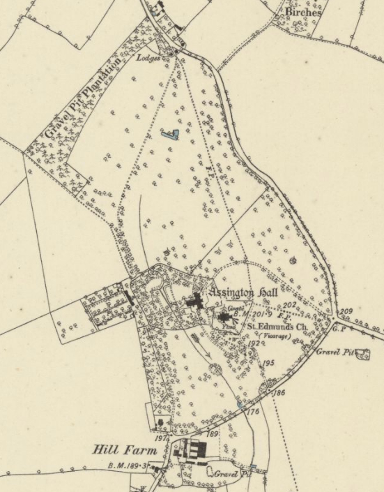
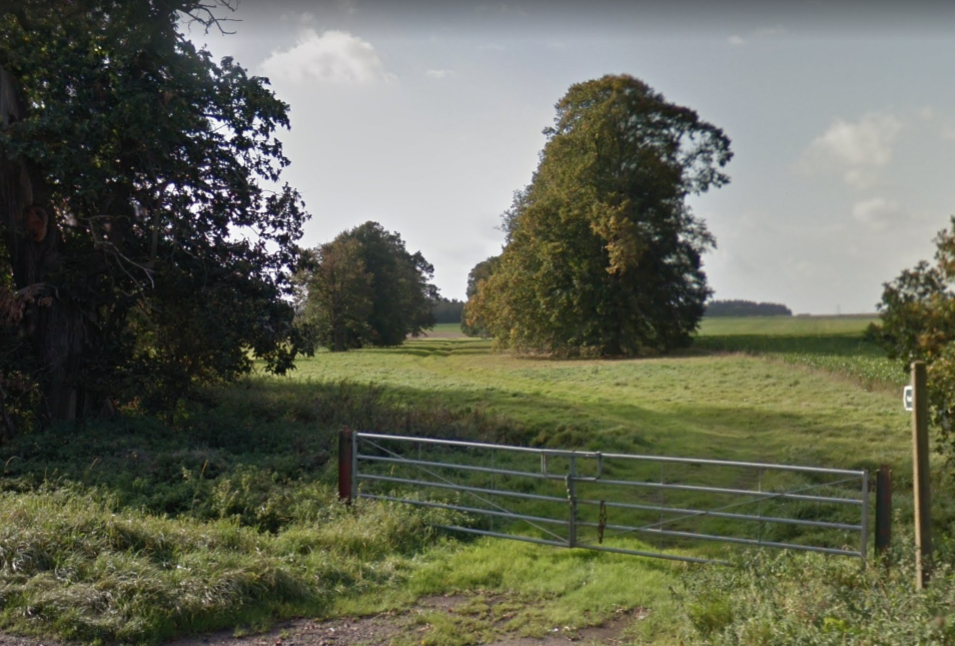
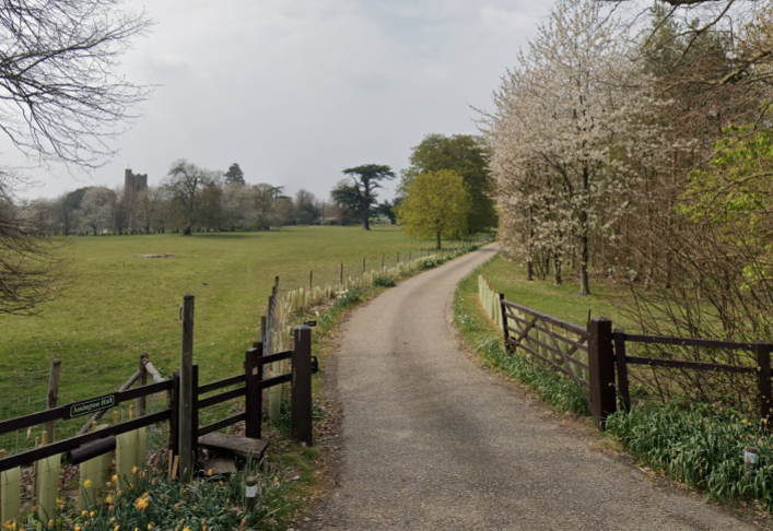
A road east of the Hall, church and lost village site originally ran north to south, but by the time of Hodkinson’s 1783 map it had been redirected further east so that the Hall and church sat isolated within its extended c. 15ha (37a) park, leaving an avenue of trees shown on the tithe map of 1837 as evidence of the road’s former route. Two small lodges are shown on the map at the northern end of this avenue that are likely to have been built as entrance lodges to a drive created from the original road into the park. These lodges survived into the twentieth century and are shown on the 1927 OS map but have since been lost, except perhaps for some humps and bumps in grass that are visible today marking the spot where they once stood.
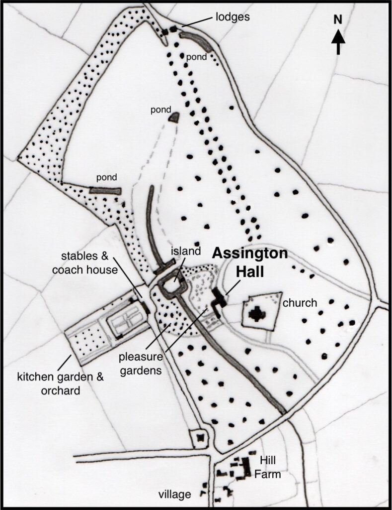
With the expansion of the park the two existing drives were created. That from the east curves through the park to the front of the house and is shown to have been lined with trees by 1885, some of which survive today. From the south-east, the other drive leads through the site of the old village to the church and forks towards the rear of the house. A small group of deciduous and coniferous trees on the valley side to the west of this drive survived into the twentieth century.
The 1837 map also marks a building at the entrance to another drive from the south and nearest to the new village main street. In this position it would be thought likely to have been an entrance lodge, however the building on the site today is a relatively substantial building that does not have the character of a lodge that had been enlarged over time and more that of a rectory, which is the name of the property today. However, maps from 1837 to 1927 show a house much further to the east, known as The Glebe House today, as the home of the rector. From here an existing straight drive passes beside a belt of trees to the late-eighteenth or early-nineteenth century stables and coach house (Grade II), which were probably built by Philip Gurdon who died in 1817. It then continues eastward to a bridge over the stream. Attached to the rear of the stables and coach house is a rectangular kitchen garden (see below).
By 1837 a shelterbelt of trees extended along the northern boundary of the park with an attached section along the north-western boundary, although shading on the following OS maps suggests that the northern plantation was not part of the original park, perhaps it was by then leased out. Freestanding trees were dotted around most areas of the park except in the north-west section. The park had expanded to c. 24ha (60a) by 1868 and the 1885 OS map shows little other change over the preceding fifty years except the loss of the avenue of trees, albeit with a few trees surviving as freestanding parkland trees amongst others dotted around the park, and addition of some freestanding trees in the north-west section. Over the following twenty years the park expanded further by taking in a section of the field to the north-west and is recorded as covering 32.3ha (80a) in 1907. At the end of the nineteenth and into the twentieth century an avenue of limes was established west of the stream in place of the trees of the north-western shelterbelt. Although begun a few years earlier, the main break-up of the Assington Hall Estate began in 1938 when it was sold in lots by the Gurdon family. Sales particulars of the time list the Hall, gardens, grounds and two cottages in 35.6ha (88a) of parkland.
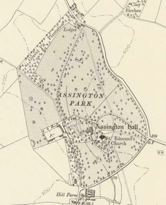
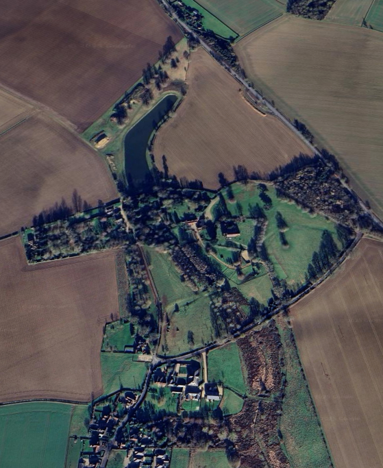
The present owners of Assington Hall retain c. 10ha (25a) of the original eighteenth century grazed parkland with a number of fine mature specimen trees, including a majestic cedar of Lebanon and oaks, and two wooded areas of c. 1.2ha (3a) with many mature trees, some dating back to the nineteenth century. One of the woods was developed during the twentieth century to the east of the main entrance drive, giving privacy and acting as a buffer between the Hall site and the main A134 road between Colchester and Sudbury. Immediately south of the Hall the parkland on either side of the stream has lost all the earlier specimen trees and is today rough grazing land. The northern section of the park of c. 12ha (30a) is now in separate ownership. It is mostly devoid of trees and turned to arable except an area of grassland, the now matured lime avenue, winding stream and a L-shaped pond that form the north-western section. A number of public footpaths cross the park.
PLEASURE GARDENS
The stream that rises to the north of the Hall flows south through the oval-shaped pleasure grounds. It is shown on the 1837 tithe map to have fed a square moated garden feature named ‘The Island’ on the apportionment and shown as tree-covered. This had an access bridge on its eastern side leading to the gardens at the rear of the Hall. It seems likely that the island was an ornamental garden similar to the Tudor moated garden recorded at Shelley Hall c. 14.5km (9mls) to the east. By the late-nineteenth century the moat had lost its distinct square shape and today remnants of two arms form the head of a long, thin tree-lined pond created by widening the stream before it flows south through the southern parkland, today lined with recently-planted trees.
Substantially unchanged since to the early-nineteenth century, to the east of the stream the sloping pleasure garden to the rear of the Hall consists of lawn, shrubs and a perimeter path that winds its way down to the ‘Island’ and the bridge to a wood on the opposite side of the stream. There are 10ha (25a) of pasture that are grazed by sheep, goats and geese. Since the early-nineteenth century there have been open views from the east-facing front elevation of the old house over a lawn and across the park with a selection of mature, freestanding specimen trees.
KITCHEN GARDEN
The tithe map shows a rectangular walled kitchen garden attached to the rear of the listed early-nineteenth century stables and coach house with an orchard beyond. These sat in a rectangular enclosure that juts out into the surrounding field. The kitchen garden is shown divided into four segments by cross-paths with a surrounding perimeter path. More paths are shown in the slip gardens to north and south leading to an orchard area to the west within the enclosure. Shading on the 1905 and 1927 OS maps suggest the kitchen garden enclosure and belt of trees to the west of the south drive sat outside the park boundary, perhaps they were originally within the park and leased out during the latter part of the nineteenth century.
Now in separate ownership, the stables and coach house have been converted into a residential property with the remains of the kitchen garden walls forming the boundary of its garden. In 1993 sales particulars describe the garden as covering an area of 0.81ha (2a). The old orchard has become the garden to a newer residential property that lies attached to the western boundary of the kitchen garden enclosure.
MODEL FARM
Just outside the park to the south and close to the new village, Sir John Gurdon who, as a progressive landowner experimented with radical ideas, set up a co-operative farm at Hill Farm (Grade II) in the mid-nineteenth century. It consisted of a courtyard of farm buildings including a large barn. Sold out of the Assington Estate in the early-twentieth century, it continued to be used for farm purposes until 2016 when the barn was converted into a modern residential property to an award-winning design.
SOURCES:
Barker, H. R., West Suffolk Illustrated, 1907.
Copinger, W. A., The Manors of Suffolk, Vol. 1, 1905.
Hoppitt, Rosemary, Deer Parks of Suffolk 1086–1602, 2020.
Roberts, W. M., Lost Country Houses Of Suffolk, 2010.
Williamson, Tom, Suffolk’s Gardens & Parks, 2000.
Williamson, Tom, Survey of Historic Parks and Gardens in Suffolk, ms. (SSF23226)
The National Gazetteer of Great Britain and Ireland, 1868.
Assington Neighbourhood Plan, Supporting Document: Assington Local Green Space Assessment 2018–2036.
https://www.assingtonhall.com (accessed December 2022)
For information on Shelley Hall see Proceedings Suffolk Institute of Archaeology 39 pt. 2, 1998, 257–64 and pt. 4, 2000, 528; also J Potter, Lost Gardens, Channel 4 Books (Macmillan), London, 2000, 32–53.
1837 tithe map and apportionment.
1885 (surveyed 1885) Ordnance Survey map.
1905 (revised 1902) OS map.
1927 (revised 1924) OS map.
Heritage Assets:
Suffolk Historic Environment Record (SHER): ASN 001, ASN 003, ASN 005, ASN 008, ASN 012, ASN 018, ASN 019, ASN 025.
Church of St Edmund (Grade I), Historic England No: 1036733.
Stables and Coach House (Grade II), Historic England No: 1276815.
Hill Farmhouse (Grade II), Historic England No: 1036703.
Suffolk Record Office (now Suffolk Archives):
SRO (Bury St Edmunds) HD 1180/80 Sales particulars for part of the Assington Hall Estate, 1921.
Suffolk Record Office (Ipswich) HE402/2/1938/55 Sales Particulars R. C. Knight & Sons, 15 July 1938.
SRO (Ipswich) HD 2833/1/SC014/6. Sales Particulars Desmond G. Boyden, 1993.
Site ownership: Private
Study written: July 2025
Type of Study: Desktop
Written by: Tina Ranft
Amended:
