Parish: BARDWELL
District Council: WEST SUFFOLK (previously St Edmundsbbury)
TL 943 777
Not open to the public
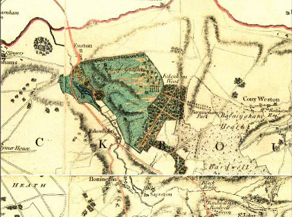
Barningham Park was an estate owned by the Sheldon family, long-standing residents of Barningham. It was in the far north of the parish of Bardwell, c. 9.5km (6mls) south-east of Thetford and c. 19km (12mls) north-east of Bury St Edmunds. Some distance from the village settlement of Barningham, Coney Weston is the nearest village. It lies in a flat arable landscape of light loams and sandy soils and is bordered to the west by Fakenham Wood, ancient woodland with its main part surrounded by a large boundary bank, which has been suggested as a possible medieval deer park. The Peddars Way, a section believed to be a Roman road, ran through the north-east area of the park.
An outline of Barningham Park is shown on Kirby’s 1736 map, Bowen’s 1755 map and in more detail on Hodskinson’s map of 1783. This shows an avenue of trees running approximately from the east westward to Fakenham Wood with the route continuing as a track through the wood to Euston Park, the surviving park that was designed by the landscape architect William Kent in the mid-eighteenth century and associated with ancient manor house of Euston Hall. Bordering the East Anglian Breckland, Barningham Park is shown on the enclosure map of 1798 as open ‘sheepwalk’ used for rough grazing. Soon after, the land was enclosed to create a 147ha (363a) tenanted farm owned by the Duke of Grafton’s Euston Estate, who had bought Barningham Park from the Shelton family during the eighteenth century.
Barningham Park (Grade II) farmhouse is thought to date from the early- to mid-nineteenth century, probably built when the farm was created and replacing an earlier house on the site that was associated with the avenue and park shown on the eighteenth century maps. The two-storey house is faced in random kidney flint and red brick with a heavily ornamented early-nineteenth century entrance porch of cast iron in the Egyptian style. There are two large surviving barns on the site. That to the south-west of the house is listed (Grade II) and dates from the early-eighteenth century with associated mid-nineteenth century cattle yards and sheds. To the north-west is a further large barn and yard complex that was built c. 1850.
By the time of the 1838 tithe map only remnants of the east to west avenue survived with another ornamental line of trees running northward from the farm site. West of the house the tithe map shows a small oval garden enclosure with surrounding belt of trees and shrubs. The two barns and farm buildings lay beyond the garden enclosure to the west along with a large pond. There were also smaller buildings immediately to the east of the house that may have been the stables. Attached to the south elevation of the house was a rectangular area with perimeter and cross-paths suggestive of a kitchen garden and adjacent orchard. By the end of the nineteenth century another avenue lined the east entrance drive to the farm.
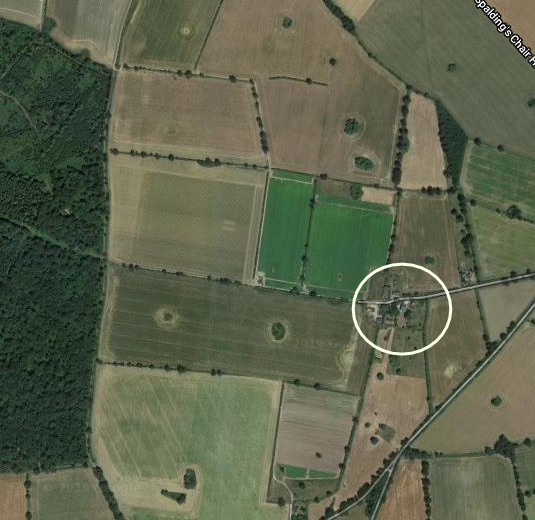
Today, the land surrounding Barningham Park farmhouse is in agricultural use and continues to be owned by the Euston Estate. A few trees have survived from the early avenues, although now form part of field hedge boundaries. In 2022 the large barns were in the process of being converted to residential properties and the house in a plot of c. 0.73ha (1.8a) was for sale in the summer of 2025, including gardens partially reflecting the early-nineteenth century garden plus the original area of orchard. This is now rough grass with the occasional freestanding tree and shrub.
SOURCES:
Alston, Leigh, The Barns, Barningham Park, Bardwell, Historic Building Record, 2010, for Suffolk County Council Archaeological Service.
Birch, Mel, Suffolk’s Ancient Sites Historic Places, 2004.
Copinger, W. A., The Manors of Suffolk, Vol. 2, 1909.
Kirby, J., The Suffolk Traveller, 1735.
Kelly’s Directory of Suffolk, 1865.
West Suffolk Planning Portal, DC/21/2361/FUL and DC/21/2362/LB (accessed June 2023)
White, William, History, Gazetteer, and Directory of Suffolk, 1844, 1874.
http://www.suffolklandscape.org.uk/landscapes/Plateau-estate-farmlands.aspx (accessed May 2019).
Census: 1861, 1871, 1881.
1736 John Kirby’s Map of Suffolk.
1755 Emanuel Bowen’s Accurate Map of the County of Suffolk.
1783 Hodskinson’s Map of Suffolk in 1783.
1838 (tithe map 1839) and apportionment.
1884 (surveyed 1882) Ordnance Survey map.
1905 (revised 1903) OS map.
1953 (revised 1950) OS map.
Heritage Assets:
Suffolk Historic Environment Record (SHER): BAR 025, 031, 063, 077, EUN 022.
Barningham Park (Grade II), Historic England No: 1376888.
Barn to South West of Barningham Park (Grade II), Historic England No: 1031341.
Length of Roman road NE of Barningham Park Scheduled Ancient Monument List Entry No: 1005972.
Site ownership: Private
Study written: July 2025
Type of Study: Desktop
Written by: Tina Ranft
Amended:
