Parish: BOXTED
District Council: BABERGH
TL 828 506
Not open to the public but available to hire for house parties, weddings and events
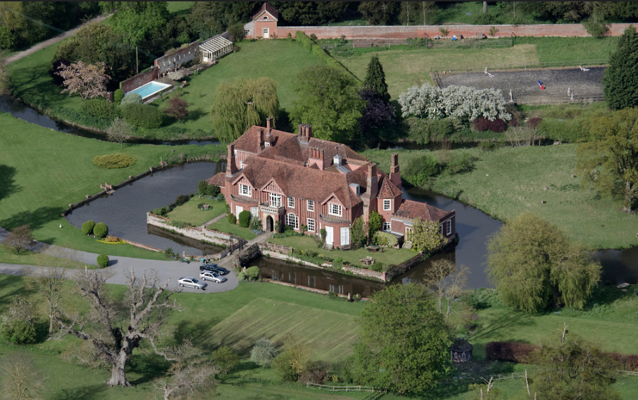
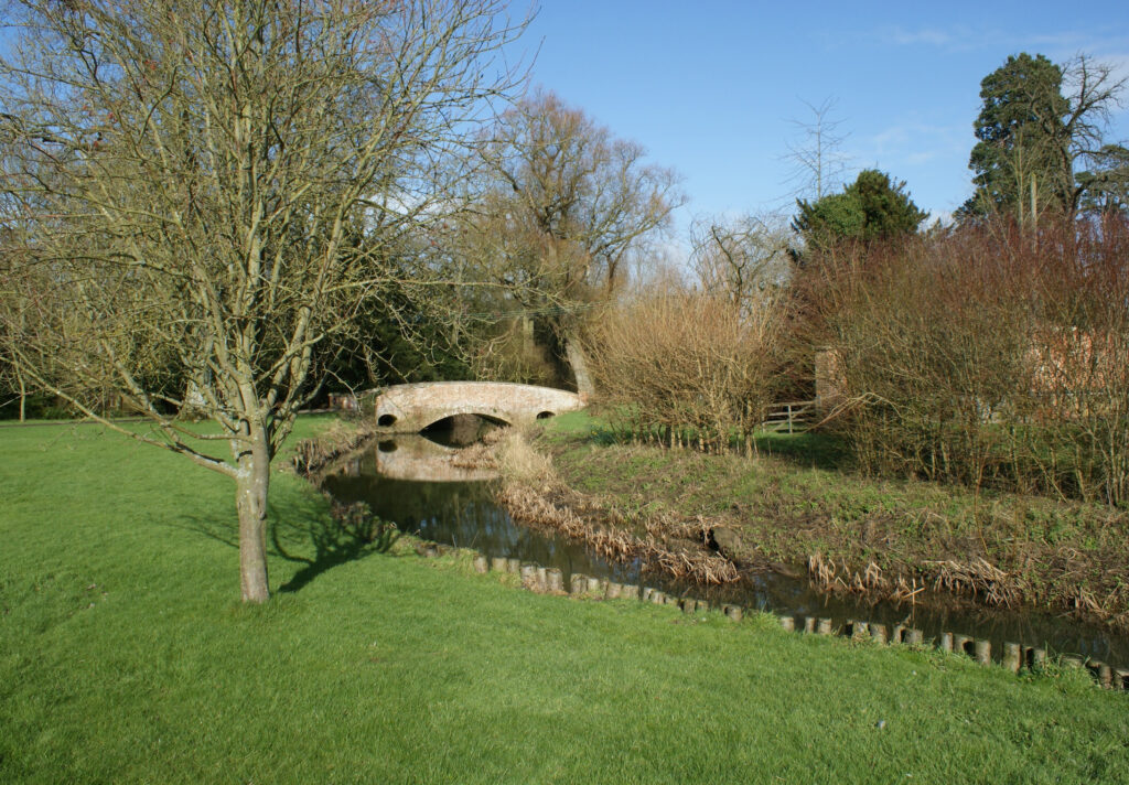
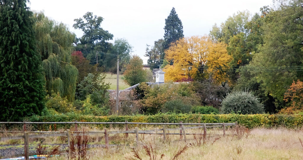
In a sheltered position in the valley of the River Glem, a tributary of the River Stour, moated Boxted Hall (Grade II*) is c. 3.2km (2mls) north of Glemsford, c. 11km (7mls) north-west of Sudbury and near the village of Hartest. The river flows behind the house to the east and feeds the moat. Boxted (historically sometimes spelt Boxsted) parish is sparsely populated and consists mainly of scattered farms and hamlets. On higher ground west of the house and within Boxted Park, the Church of the Holy Trinity (Grade I) is a small brick and flint church said to have origins in the thirteenth century, but is mainly fifteenth century. It is famous for its painted wood effigies and memorials to the Poley and Weller-Poley families who have owned Boxted Hall (Grade II*) since the fourteenth century.
BOXTED HALL AND ITS OWNERS
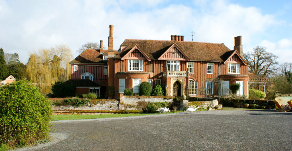
The Poley family came to Suffolk in the late-fourteenth century from Poley in Hertfordshire to arrive at Boxted and Badley, near Needham Market. The first moated hall at Boxted was built by Sir John Poley in 1392 and replaced by the current sixteenth century timber-framed house built by William Poley. The last Poley was Richard who died 1757 when the estate was left to his nephew George Weller. George’s mother was Elizabeth Poley who was married to Robert Weller of Tunbridge Wells. On inheriting the estate George took the name Poley to become Weller-Poley. George made some alteration to the house before he died in January 1779 and in 1820 two new wings were added.
Within a rectangular moat, Boxted Hall is accessed across a four-arched red-brick bridge that has medieval origins. The tithe map of 1840 depicts the moat with a slightly irregular outer edge and a ‘tail’ flanked by ornamental trees to the south with a tree-covered island, although today there are two islands and no ornamental trees. The 1841 census records George Weller-Poley (born c. 1789) with wife Helen and four of their children in their twenties plus five resident servants living at the Hall. By 1851 George’s eldest son John George Weller-Poley Esq. (born c. 1812) had inherited the estate. He was Deputy Lieutenant and a magistrate of Suffolk and living at Boxted with his wife Diana (born c. 1817), the daughter of Thomas Hallifax who built Chadacre Hall in 1834. There were no Hallifax male heirs so the Chadacre Estate passed into the Weller-Poley family. John George and Diana had two young sons at the time of the 1851 census, John George (born 1849) and Thomas (born 1851) plus ten servants.
By the time of the 1871 census John George had died and Diana was the head of household, although their son John George, now twenty-two years old, is recorded as the owner of the estate. At the time his brother Thomas was an undergraduate studying law who went on to live in Sussex.
After Diana’s death in 1884, son John George is recorded living at Boxted Hall with his wife Ethel. At the end of the century the old plastered façade of the west-facing front elevation was covered by red bricks within timber-framing to create the house as it is seen today. George and Ethel had no children so the Boxted Estate passed down through the Weller-Poley family who continue to own the estate today.
THE PARK
The Poley family had a medieval deer park at Boxted that was recorded in 1454, although its exact extent is unclear. A number of pockets of surviving ancient woodland are likely to have been within the park’s boundaries. These lay mostly to the west of the house such as Longley Wood and Lownage Wood. Other pockets of woodland such as Oak Grove and Church Wood are both near the church. Asgood Wood and Bridewell Grove may also be ancient woodland. The Weller-Poley landholding extended to the eastern parish boundary and included Nine Acre Plantation. Although the word ‘plantation’ suggests seventeenth century origins, there is least one bank and ditch within it that appears to be an earlier earthwork suggestive of ancient woodland. A written survey in the form of a Glebe Terrier of 1630 and 1631 refers to a ‘warren for conies’ on the hill between the house and the church, the word ‘conies’ being the historic name for rabbits. Earthworks of field boundaries dating to this period have also been found.
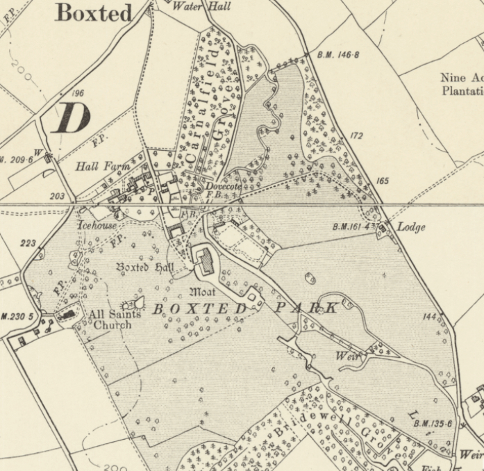
The landscape park that developed at Boxted is shown on Hodskinson’s 1783 map as a trapezoid shape and extended approximately east to the road between Stanstead and Hartest villages, west to the church, south to a shelterbelt of trees known as Bridewell Grove and north to include Carnalfield Grove. The River Glem meanders its way through the park and feeds regular channels within Carnalfield Grove, and also those south-east of the house and north of Bridewell Grove. The regularity of the channels are suggestive of wildfowl management, although those nearest the house may also be part of the pleasure grounds at Boxted.
The tithe map of 1840 depicts the park of c. 36.4ha (90a) surrounding the house and extending to the northern parish boundary with Somerton. It had small areas of woodland dotted throughout and freestanding trees between the church and the Hall. At the time there was a circle of trees surrounding a small round pond and two further oblong-shaped ponds between the church and house. The stable courtyard (Grade II) is just north-west of the house with a large pond and a complex of walled enclosures on rising ground beyond. Hall Farm lies close-by. The parkland rises abruptly in front of the house westward to the church. The main entrance drive is from the east with a rear drive off the road leading to the church from the north, today called Braggon’s Hill. This drive passed through fields and gave access to Hall Farm and stable courtyard before joining the main eastern drive close to the house. The road to the church, referred to on the tithe apportionment as ‘gated in’, marks the western extent of Poley land and was owned by John Spencer Westrop who leased it to Samuel Isaac. Fields further west were owned by the Marquis of Downshire, an Anglo-Irish peer.
The most direct footpath from the Hall to the church lead from the rear of the stables and shirted the grounds of Hall Farm before passing through an area of the parkland dotted with trees, to join the lane from the north to the church. Vehicle access from the house to the church would have been from a track north of the farm or by taking the rear drive northward. It is believed that the main access to church has altered since 1840 and the original road is now just earthworks in the park.
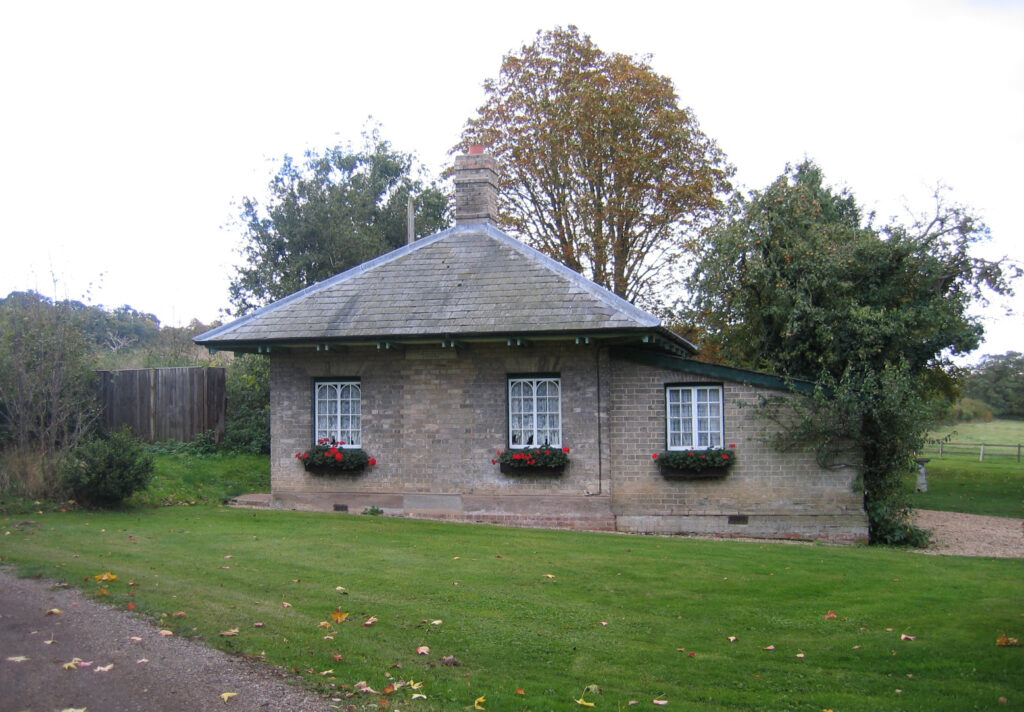
The main entrance drive into the park is shown on the 1836 OS map flanked by an avenue of trees and taking a direct route from the north-east, off today’s B1066 road, and bridging the River Glem to arrive at the west-facing front of the house. During the following years shelterbelts of trees were added beside the road and William Robinson writing in The Garden in 1873 noted that conifers had been planted in these shelterbelts around the park in the early-nineteenth century and the landscape park had expanded slightly to c. 40.5ha (100a). By the time of the 1884 OS map the entrance had moved further south so that the drive took a more curving route than earlier in the century. It now ran northward and parallel to the edge of a shelterbelt with its mixed planting of coniferous and deciduous trees before joining the earlier route, although now minus the avenue of trees. Probably around the same time a new entrance lodge was built that survives today in an almost unaltered condition.
A round dovecote at the southern end of Carnalfield Grove and near the stable courtyard is first named on the 1905 OS map, although it is shown as a circle on the tithe map and an un-named dot on the 1884 map. The site is likely to have been in use for a dovecote for many centuries and perhaps contemporary with the original fourteenth century house. One of the water channels within the grove was diverted to almost encircle the dovecote and appears to have been part of the pleasure gardens. The dovecote survived into the twentieth century but has now gone although the mound on which it stood is still visible and shown on recent LiDAR images. Also of an early date but likely to have been constructed in the eighteenth century, an icehouse lay close to Hall Farm and survived into the twentieth century.
THE STABLE COURTYARD
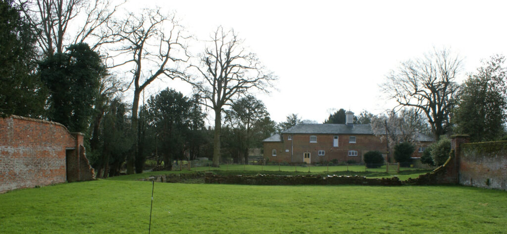
The stables at Boxted Hall are shown on the 1840 tithe map as an open courtyard looking south towards the house. On one of its brick buildings there is a panel with the date ‘1851’ and initials ‘J G W P’ for John George Weller-Poley (born c. 1812) suggesting the courtyard was rebuilt or renovated at that time. The courtyard has recently been converted for residential use and become the home of the current resident Weller-Poley family.
THE MAIN WALLED GARDEN
The rear of the house faces north-east and looks over the moat and River Glem into the main partly-walled garden (Grade II). The red-brick walls of this large garden probably date from the mid-eighteenth century, soon after George Weller inherited the estate from his uncle Richard Poley. It would have been built mainly for its visual impact and an expression of the status of the family and used for ornamental and recreational purposes. Its original use changed and it was described as a kitchen garden on the 1840 tithe apportionment. The accompanying map shows it surrounded by a shelterbelt of coniferous and deciduous trees. In 1873 William Robinson described it as a ‘fruitful kitchen garden’ with vineries, glasshouses and peaches on walls.
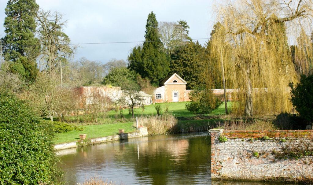
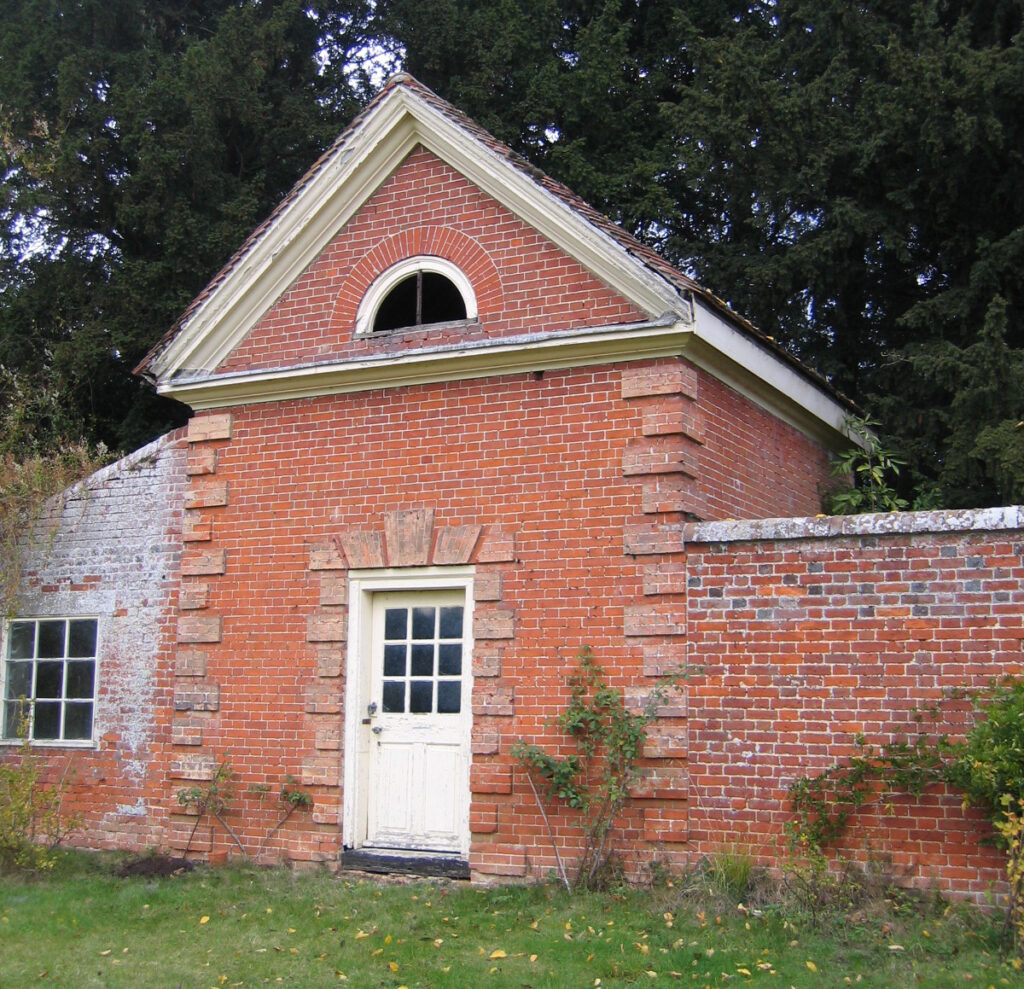
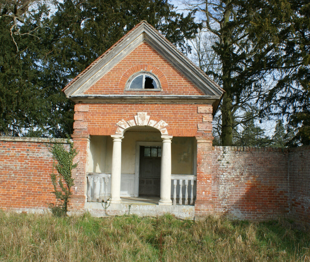
The garden was originally built with two pavilions, in the rusticated-style most associated with the eighteenth century, along its longest wall facing the house and are depicted on an estate map of 1767. They were constructed on the outside of the wall with their front faces flush with the wall and accessed from within the garden. The more northerly pavilion is the simpler of the two being just a small room attached to adjoining sheds with a rusticated doorway. The pavilion to the south-east is more elaborate and has an ornate open veranda with rusticated arch and columns. Behind are small rooms, including a water closet. It seems likely that this was a covered retreat from where the garden and house could be viewed, and perhaps a place to enjoy afternoon tea.
The adjoining shorter walls of the garden splay out and appear to have once reached the bank of the river. During the nineteenth century there were lean-to glasshouses against the most northern wall facing south into the garden, with a taller central glasshouse that was probably used as the vinery. This wall has a number of surviving back sheds and there is evidence of a gateway and former in-filled gateway giving access from the outside of the garden. Towards the end of the century the 1884 OS map shows the garden had a perimeter- and two cross-paths lined with trees, probably various fruit trees. The garden continued to be used for growing fruit and vegetables well into the twentieth century but lost part of its south wall. In the 1970s it became a horse riding arena or manége and is now used for other recreational purposes with a small swimming pool that appears to have been constructed on the brick base of an earlier glasshouse, a tennis court and the rest rough grass.
THE WALLED GARDEN COMPLEX AND PLEASURE GROUNDS
With little room for gardens within the moat, Boxted Hall’s small pleasure grounds are mainly to the north of the house. The 1840 tithe map shows them to have been a mixed planting of coniferous and deciduous trees, including surviving walnut trees and giant redwoods. Behind the stables courtyard a large pond survives with some brick revetting along the sides. This pond appears to have been lozenge-shaped during the nineteenth century but today is almost circular.
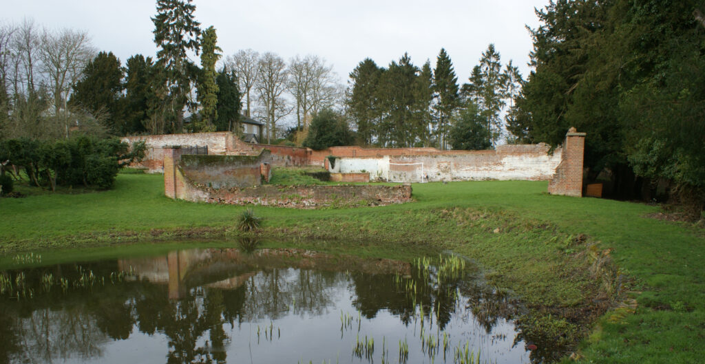
To the north of the pond is a complex walled gardens of unknown date and built on rising ground with two or more levels. These were in existence in the early-nineteenth century and shown on the tithe map of 1840 when they consisted a square garden laid to lawn attached to the pond, a second rectangular walled enclosure dotted with ornamental coniferous trees to its west and a further small enclosure to the north. This suggests the larger two enclosures were used for ornamental purposes at this time. It is possible they were built in the eighteenth century as kitchen gardens when the main walled enclosure to the east of the moated house had ornamental purposes, becoming part of the pleasure gardens when the main walled garden began to be used as a kitchen garden. By 1884 the square garden had become an orchard with a lean-to glasshouse in its north-east corner and the other enclosures had glasshouses and appear to have been used either as a kitchen garden or perhaps plant rearing and cut flowers areas.
The square garden has a lower southern wall which allows views out across the pond towards the stable courtyard and house beyond. The remains of this wall curve upwards to join the height of the side walls with their moulded copings, the form and detailing suggesting it was built to be seen and intended as part of the pleasure grounds rather than a kitchen garden. Under a soil mound there are a set of curved steps between this enclosure and that to the west. Oral evidence from an older member of the family remembers these gardens as orchards during the early part of the twentieth century, although they were turned over to horse riding arenas or manéges later in the century. The glasshouses shown on the 1884 OS map were lost during the twentieth century and the western and northern enclosures became overgrown. By 2016 the square garden was under grass, although devoid of any remaining fruit trees, and used by the resident Weller-Poley family for sporting activities such as football. More recently the western and northern enclosures have been joined to create an L-shaped walled enclosure with a developing kitchen garden.
At a lower level, a channel fed by the River Glem once curved around the dovecote to flow northward through Carnalfield Grove, which William Robinson writing in 1873 said created various ponds with water lilies, reed beds and willows. He also wrote about early-nineteenth century conifers within the grounds, with shrubberies, a small fern garden and a ‘root garden’ or stumpery, a popular Victorian garden feature created from tree stumps, logs, and other woody material. The 1905 OS map shows a path leading from the drive near the house across a lawn dotted with coniferous and deciduous trees and then bridging the water channel beside the dovecote to arrive at the south-east corner of the square walled enclosure, where a gateway survives but without a door. This area is now overgrown and it is unknown if the path still exists.
A surprising number of nineteenth century garden features and trees, with some dating back to the eighteenth century, have survived in the gardens around Boxted Hall, although somewhat overgrown and in need of pruning and thinning, clearing and restoration work, which are all part of a current programme of works.
SOURCES
Barker, H. R., West Suffolk Illustrated, 1907.
Blomfield, Reginald, The Formal Garden in England, 1892.
Burke, John, Encyclopaedia of Heraldry or General Armory of England, Scotland and Ireland, 1844.
Burke, John, A History of the Landed Gentry of Great Britain & Ireland, 1879, 1914 Part 2.
Cox’s County Who’s Who Series, Suffolk, 1912.
Hoppitt, Rosemary, Deer Parks of Suffolk 1086–1602, 2000.
Kelly’s Suffolk Directory, 1892, 1912, 1933, 1937.
Robinson, William, The Garden, June 21, 1873.
Suffolk Gardens Trust, Walled Kitchen Gardens Recording Group, Peter Cunard, ‘Boxted Hall Walled Gardens’, 2016, unpublished document.
White, William, History, Gazetteer and Directory of Suffolk, 1844, 1855.
https://www.foxearth.org.uk/1778IpswichJournal.html.
http://www.buryfreepress.co.uk/news/business/business-news/hall-looks-to-future-with-seminar-plan-1-40167716:15Thursday 27 July 2006. (accessed January 2021)
https://shimpling-pc.gov.uk/organisations-and-clubs/hallifax-trust/ (accessed October 2025)
Census: 1841, 1851, 1861, 1871, 1881, 1891, 1901, 1911.
Kirby’s 1736 map of Suffolk.
Hodskinson’s Map of Suffolk in 1783.
1840 tithe map and apportionment.
1884 (surveyed 1884) Ordnance Survey map.
1905 (revised 1902) OS map.
1927 (revised 1924) OS map.
2023 Google aerial map (Imagery © Bluesky, CNES / Airbus, Getmapping plc, Infoterra Lts & Bluesky, Maxar Technologies, Map data © 2023).
LiDAR image Crown copyright Scottish Government, SEPA, Fugro and Scottish Water (2012-2022).
Heritage Assets:
Suffolk Historic Environment Record (SHER): BXT 004, 010, 014, 016, 017, 024, 025, 031, 032, 038, 055.
Boxted Hall (Grade II*). Historic England No: 1351740.
Church of the Holy Trinity (Grade I). Historic England No: 1351739.
Garden Wall and Pavilions to Boxted Hall (Grade II). Historic England No: 1036707.
Stables at Boxted Hall (Grade II). Historic England No: 1194356.
Suffolk Archives (previously Suffolk Record Office):
(SA) BA500/F/6/2/11, Diversion of Public Highway, May 1819.
(SA) HD526/17/4, Photographs of Boxted Hall, The Revd Edmund Farrer, nd.
Site ownership: Private
Study written October 2025
Type of Study: Desktop and site visit 2016
Written by: Tina Ranft
Amended:
