Parish: KELSALE CUM CARLTON
District Council: EAST SUFFOLK (previously Suffolk Coastal)
TM 381 640
Not open to the public
Destroyed by fire in 1941, eighteenth century Carlton Hall once stood in a landscape park north of Saxmundham and beside the old main road from Ipswich to Lowestoft, now the B1121 after the opening of the Saxmundham bypass in 1988 diverted traffic to the west. The Gull Stream flows through the parkland from north-west to south-east to join the River Fromas.
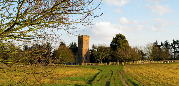
Although historically closely linked to Kelsale, Carlton was a separate parish until 1885 when the two parishes were joined to become Kelsale cum Carlton. Both were once rural farming parishes on the edge of the central Suffolk clayland plateau, although Kelsale was an important medieval manor. Founded in 1330 as a chantry for three chaplains to pray for the soul of Alice, the first wife of the Earl of Norfolk, Carlton’s Church of St Peter (Grade II*) stands in an isolated position within the parkland of Carlton Hall.
OWNERS, OCCUPIERS AND THE HALL UP TO 1850
A Carlton Hall was in existence by 1655 when owned by a man called Osborne, who is described in documents as from Kent. This house is thought to have been on a slightly different site to eighteenth century Carlton Hall and perhaps part of a lost settlement based on the parish church.
From the early-eighteenth century the actual manor of Carlton was owned by the Bence family of Thorington, which lies c. 12km (8mls) to the north beside the road to Lowestoft. At the time they were also Lords of the manor of Kelsale. However, the Carlton Hall Estate is thought to have been the home of a lord of the manor, suggesting the Carlton Hall Estate and the manor of Carlton were originally separate.
By 1753 the Carlton Estate was owned by William Fuller and his wife but was sold in that year by their mortgagees to Osborn Fuller Esq. from Tottenham, then in Middlesex. Although with the same surname, there is no known evidence to suggest the Fullers were related, even though it seems a distinct possibility. Osborn made Carlton Hall his home. Excavations in the twentieth century suggest it was a mid-eighteenth century building, so it seems likely that Osborn was responsible for building the new Carlton Hall. He expanded the landholdings of the estate and probably created the landscape park around his new house.
On Osborn’s death in 1794 the estate passed to his son Edward Fuller Esq. (b. 1782) of Brighton. Edward continued to purchase land to add to the estate but these were subject to mortgages, some of which were later sold to Lionel Dove in 1837. The house is said to have been extended during the nineteenth century, possibly by Edward as he wished the house to be commensurate with the expanded estate. By 1843 the tithe map and apportionment record Carlton Hall and part of the landscape park as leased to the Hon. Charles Vanneck, whilst Edward lived abroad. William White writing in 1844 described the house as a ‘large handsome mansion, in an extensive and well-wooded park’, obviously a property suitable for Charles, the son and heir of Joshua Vanneck, who on his father’s death in 1844 became the third Baron Huntingfield of Heveningham Hall.
OWNERS, OCCUPIERS AND THE HALL FROM 1850
In 1850 the estate was bought by Edward Walter Bonham. He lived in France and immediately transferred the ownership to his son Henry on his marriage to Augusta Musgrave. Six years later Henry died and his widow became the effective owner of the Carlton Hall Estate until it became part of the marriage settlement of her son Henry Walter Musgrove Bonham in 1875. In the interim Augusta married the second Earl of Stradbroke, becoming the Countess of Stradbroke, and continued to lease out the property.
By the time of the 1861 census Richard Garrett III (b. 1807) from Leiston was the new resident. Richard had built up the family engineering business into the leading developer and manufacturer of agricultural equipment with the world’s first ‘flow line’ assembly plant, today The Long Shop Museum in Leiston. After Richard’s death in 1866 his widow remained at Carlton, which was later occupied by their son, also Richard. While they leased Carlton Hall and Park, the Garrett’s extended their landholding in the surrounding area. This included buying the adjoining Carlton Rookery Estate, which ultimately became part of the Carlton Hall Estate. Eventually the Garretts left Carlton Hall when it was leased to Capt. George Price, who obviously used his Royal Navy connections to become the Conservative Member of Parliament for Plymouth Devonport.
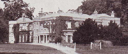
In 1905 Major-General Sir Ronald Lane took the tenancy of Carlton Hall and two years later he and his wife bought the estate. A photograph of Carlton Hall probably taken c. 1930 shows the south-west-facing entrance front of a large three-storey house with the main drive from the south-east passing the front of the house towards the stables beyond. The central core of the house is shown with classic Georgian features and later two-storey Victorian wings. After the death of Sir Ronald in 1937 the 237ha (586a) estate was for sale. It seems unlikely it sold before the start of World War II when the house was requisitioned by the government, with the loss of the main block of Carlton Hall when it burnt down on Christmas Day 1941.
After the war the estate was broken up, leaving just 47ha (117a) of Carlton Hall Estate for sale in 1948. This included the remaining west service wing that was converted into two houses, two cottages, lodge, woods, parkland, gardens, walled garden, stables, garages, barns and other outbuildings. Afterwards Sir Maurice Batho lived on the estate, although it is not known if he leased or owned it.
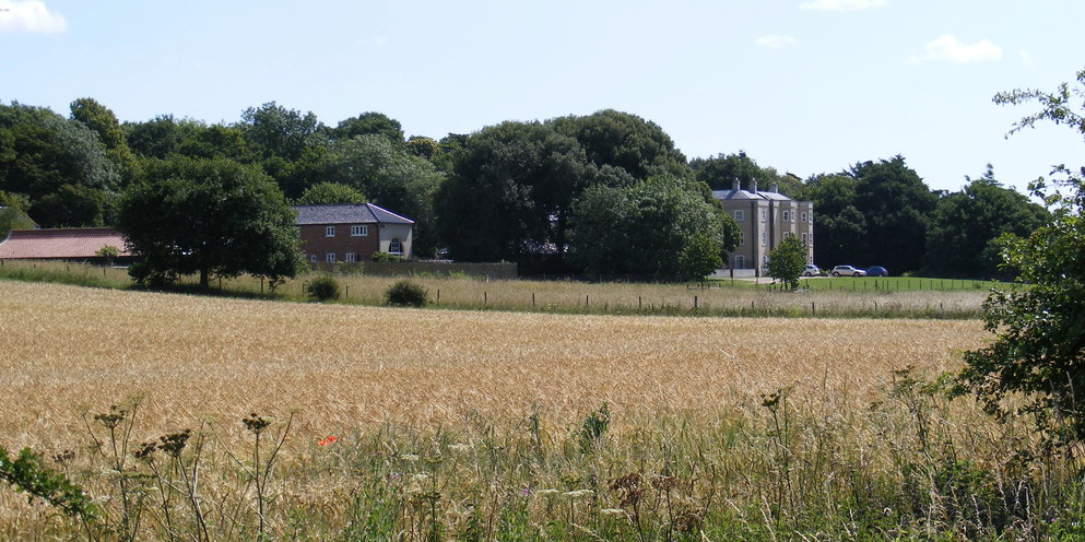
At the beginning of twenty-first century the house and remaining buildings were sold for redevelopment. This created two houses from the service wing with the stables converted into further houses. A new group of townhouses whose overall design and features make reference to the lost eighteenth century mansion were built on the house site. The walled garden became another property when outbuildings were restored, extended and converted to residential with the walls substantially rebuilt.
CARLTON PARK
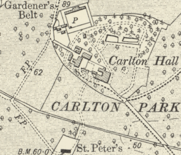
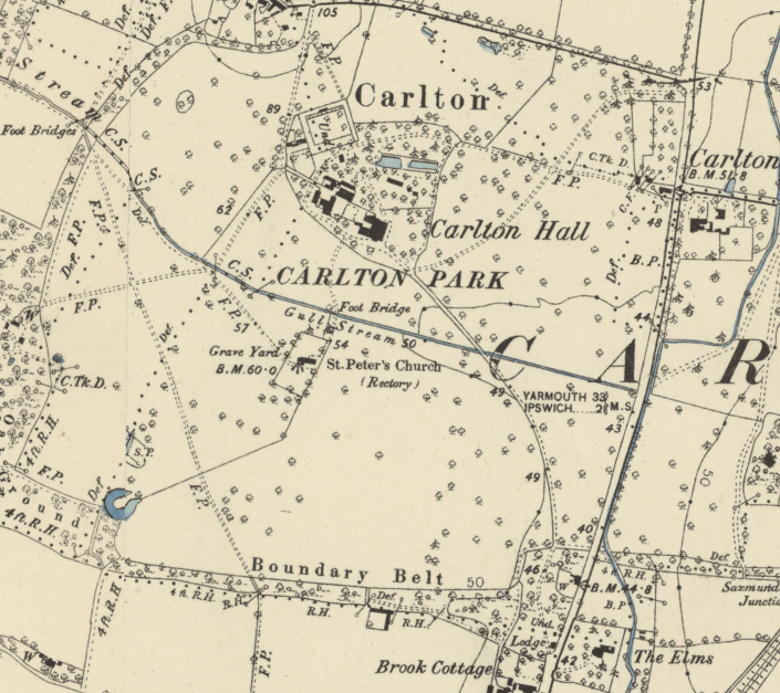
The landscape park for Carlton Hall was created in the eighteenth century, probably at the time the house was built by Osborn Fuller Esq. and later developed by his son Edward. It is shown in a general way on Hodkinson’s 1783 map and Bryant’s map of 1825. It has been suggested that prior to the creation of the landscape park there was an entrance drive towards the original house running from the main Ipswich to Lowestoft road, creating a crossroads with Clayhills Road. This may have been the ‘sunk fence or old road’ referred to in an 1825 survey. It is likely it was closed when the eighteenth century landscape park was created. Shown on the 1885 OS map as a footpath, at the end of the twentieth century it survived as a substantial ditch on the northern boundary of the eighteenth century Carlton Hall pleasure gardens. This may suggest the original hall fronted this road and lay to its north.
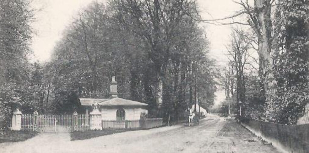
By the time of the tithe map in 1843 the parkland extended south of the Gull Stream to include the parish church, that was surrounded by trees. The park had shelterbelts of trees to the south and west, but not along the northern boundary with the road that runs westward towards Rendham, today called Carlton Road, nor the eastern boundary with the old main road, now the B1121. An icehouse, some remnants of which survive, lay south-west of the house and near to the stream. Although probably dating to the mid-eighteenth century when the landscape park was created, the icehouse could be associated with the previous hall. In the first half of the nineteenth century there were two entrances, both flanked by trees. The drive from the north-east is perhaps that shown on the 1783 map, although the drive from the south-east appears to be a later addition. The latter had an entrance lodge at its southern boundary with Saxmundham.
By 1885 the main drive was from the south-east and the north-east drive had become a secondary drive or perhaps only a footpath that was crossed by another path leading eastward that is possibly the old hall entrance drive. A path also connected the hall to the church with a further path from Carlton village to the north skirting the hall site and on to the medieval parish church, suggesting the path must have been in existence for many centuries. Off this was a secondary path leading directly to the north-east corner of the walled garden. The parkland was extensively dotted with freestanding trees.
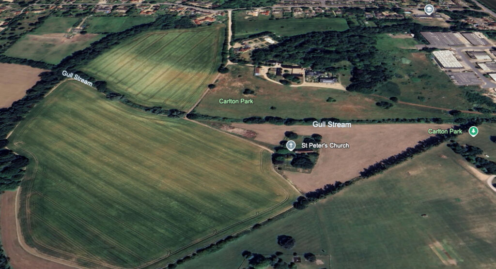
By the mid-twentieth century the landscape park covered c. 78ha (192a) but it reduced after the estate was further broken up and with the loss of Carlton Rookery Park. By the end of the century it had reduced further. A number of houses were built on the former Carlton Hall parkland along Carlton Road, where there is also a primary school that opened in 1962. Further parkland was lost to an industrial estate to the east of the house.
Today Saxmundham Sports Club owns c. 11ha (27a) of the remaining parkland with sports pitches and a caravan park, while the properties on the hall site share between them c. 7.7ha (19a) of gardens and parkland, where a few nineteenth century trees survive. The rest of the former parkland south of the stream has now been converted to arable. After the loss of the south-east section of parkland in the mid-twentieth century, a new drive with an entrance lodge was created that passed between the industrial estate and sports fields to the B1121, although this now acts more as a track and the entrance lodge is believed to be detached from the parkland. The main entrance to the hall site is now from the north, sharing the track to the church. In recent years trees were planted along the northern section of the track forming an avenue. The late-eighteenth or early-nineteenth century shelterbelts survive, although the southern belt has been encroached on by the Brook Farm housing development.
PLEASURE GARDENS AND WALLED GARDEN
The tithe map of 1843 depicts the house within a triangular garden enclosure, with corners to the south-east, north-east and north-west, lying north of the stream. It is possible that its eastern and southern boundaries were formed by a sunken fence or ha-ha. The house, stables and offices were in the south of the enclosure with open views across the parkland southward to the church. Almost half of the enclosure consisted an area of trees to the north of the house, which tapered to a point at the north-east corner of the enclosure. Next to this were two surviving large rectangular ponds, said originally to have been fishponds. However, if the original house fronted the ‘lost’ road from the east it is possible they represent late-seventeenth or early-eighteenth century ornamental canals associated with it. These may have flanked a path or track on the central axis of pleasure gardens that extended beyond the Gull Stream to the church. By 1843 the ponds were in a lawned area that continued around the eastern side of the house, giving open views of the eastern parkland. A large square walled garden surrounded by slip gardens was attached to the enclosure at its north-west corner.
Little changed in the gardens over the following forty years, although a mix of additional freestanding coniferous and deciduous trees appear to have been planted in the lawned areas and more paths passed through them to encircle the ponds. By 1885 the outer boundary of the garden enclosure continued to be a strong feature separating the enclosure from the parkland. There was a small building within these areas near to an entrance into the walled garden that is likely to be a summerhouse, with three further small buildings of unknown use just south of the ponds. The walled garden had a lean-to glasshouse on the north wall facing south, with a small central backshed on the outside. With such a small shed behind the glasshouse, other buildings such as sheds and possibly bothies for accommodating the gardeners were placed outside the walled garden to the south-west.
By the beginning of the twentieth century part of the parkland was taken to allow an extension to the tree belts around the garden enclosure to the north-east and an additional area of lawn to its south. Today a number of nineteenth century trees to the north of the house site survive and part of the garden enclosure boundary has been in-filled or degraded, although LiDAR images show the shadow of these around the current gardens to the north and east of the site of the new houses.
SOURCES:
Birch, Mel, Suffolk’s Ancient Sites, Historic Places, 2004.
Carlton Hall, Carlton, Nr. Saxmundham, Suffolk ‘A History of the Landscape’, lecture notes in the hands of this report’s author by an unknown source and date.
Copinger, W. A., The Manors of Suffolk, Vol. 4, 1909.
Cromwell, Thomas, K., Excursions in the County of Suffolk, 1819.
East Suffolk District Council, Supplementary Planning Document, June 2021.
Grace’s Guide to Industrial History, Engineering.
Kirby, John, The Suffolk Traveller, 1764.
Suffolk Coastal District Council, Kelsale Conservation Area Appraisal, November 2018.
Page, Augustus, Supplement to the Suffolk Traveller [of J. Kirby] or Topographical and Genealogical Collections, Concerning That County, 1844.
Roberts, W. M., Lost Country Houses of Suffolk, 2010.
The Women’s Institute 1922–2000, Kelsale-cum-Carlton memorial booklet.
The Suffolk Coastal Local Plan, Supplementary Planning Guidance 6, Parks and Gardens, December 1995.
White, William, History, Gazetteer and Directory of Suffolk, 1844, 1855.
Suffolk Gardens Trust visit to walled garden property, 2008.
Census: 1861, 1871, 1891, 1901, 1911.
Hodskinson’s Map of Suffolk in 1783.
Map of the County of Suffolk, from an actual survey by A. Brant in the years 1824 and 1825.
1843 tithe map and apportionment.
1885 (surveyed 1881 to 1883) Ordnance Survey map.
1905 (revised 1903) OS map.
1928 (revised 1925) OS map.
1951 (revised 1946 to 1948) OS map.
2023 Google aerial map (Imagery © Bluesky, CNES / Airbus, Getmapping plc, Infoterra Lts & Bluesky, Maxar Technologies, Map data © 2023).
LiDAR image Crown copyright Scottish Government, SEPA, Fugro and Scottish Water (2012-2022).
Heritage Assets:
Suffolk Historic Environment Record (SHER): KCC 022.
Church of St Peter (Grade II*), Historic England No: 030668.
Suffolk Archives (previously Suffolk Record Office):
(SA) HB 441/A. Administrative documents related to the Carlton Hall Estate.
(SA) HB 441/A/1. Deeds relating to repurchase, 25/26 June 1753.
(SA) HB 441/A/57. Deeds of Suffolk Properties, including the Carlton Hall Estate. 1782–1929.
(SA) HB 441/A/24. Evidence of title to the estates of the Revd Bence Bence (formerly Sparrow), 1809.
(SA) HD 11/475/Kelsale /999. The Survey of Carlton Hall Estate, 1825.
(SA) HB 441/A/35. Premises in Carlton, Kelsale, Saxmundham and Rendham, including Carlton Rookery, 1709–1897.
(SA) HD 2833/1/SC245/2. Carlton Hall Estate Sales Particulars, 1 December 1948.
Site ownership: Private
Study written: November 2025
Type of Study: Desktop and site visit 2008
Written by: Tina Ranft
Amended:
