(demolished 1956)
Parish: BRAMFORD
District Council: MID-SUFFOLK
TM 112 467
Not open to the public
The site of the former eighteenth century Bramford Hall is c. 4km (2mls) north-west of Ipswich on rising ground overlooking the Gipping River valley. It is c. 1km (0.5ml) to the west of Bramford village, itself west of the river. The house was demolished in 1956 and once stood in a landscape park, probably developed at the same time as the house.
Originally a clothier from Ipswich, William Acton (d. 1616) began acquiring land in the parish of Bramford during the sixteenth century. His son, John Acton (b. 1587), acquired further land in Bramford and the surrounding parishes and is believed to have built the first Bramford Hall in the 1630s. It was a large house recorded as having 15–19 hearths in 1674 and probably laid out around a courtyard. John’s son, William Acton (c. 1684–1744), is named on Faden’s 1736 map beside this house. He was MP for the notorious ‘rotten’ borough of Orford during a ten year period from 1722 to 1734.
The house was extended or rebuilt in the middle of the eighteenth century, probably by William’s brother Nathaniel Acton of Livermere Park. Nathaniel appears to have had an interest in botany and is recorded as having swapped plants with William Beeston Coyte of Dr Coyte’s Botanic Garden in Ipswich. William had taken the post of curate of Bramford c. 1759, which was likely to be when the two men’s paths first crossed. However, William did not pursue his religious profession, instead becoming a doctor of medicine and enthusiastically maintaining the garden his father had passed on to him and becoming a keen plantsman and well-connected collector. The garden no longer exists but is today marked by a narrow cobbled street named ‘Coyte Gardens’ between Princes Street and Friars Street in the centre of Ipswich.
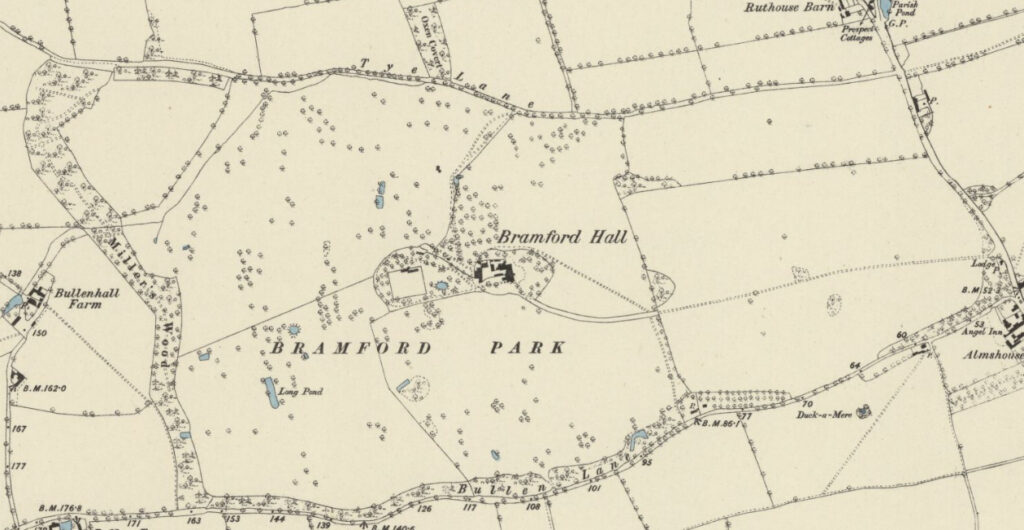
Hodskinson’s 1783 map shows the new house in a park stretching from its western boundary bordering the ancient woodland of Miller’s Wood and eastward towards Bramford village. Roads running east to west formed the northern and southern boundaries, the northern Tye Lane from Flowton to the river and the southern Bullen Lane from Burstall.
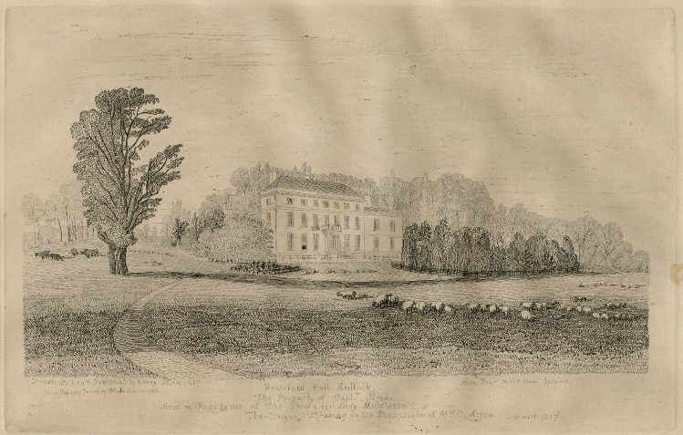
The Bramford Hall Estate stayed in the Acton family until the death of Nathaniel Lee Acton in 1836 when it passed through the female line to the Middleton family of nearby Shrubland Hall and then the Broke family of Broke Hall in Nacton, Suffolk. Annotation on an engraving of Bramford Hall drawn and etched by Henry Davy c. 1839 says ‘The Property of Capt. Broke. And a residence of the dowager Lady Middleton.’ It shows the Hall’s east-facing entrance front with three floors plus cellars and a two storey wing to the north. The main wing had a central raised entrance and railings, it’s windows with extensive views towards the river over gently-sloping parkland. A small area of sloping lawn is shown directly in front of the house separated from the parkland by a ditch or ha-ha. Within this area and off-set to the north was a thickly-planted bed of shrubs and trees obscuring the view in front of the north wing, which was presumably the service wing. A narrow driveway from the east curved northward towards the house. Although the parkland appears mostly devoid of trees, one lone mature tree stood at the edge of the drive and ditch with dense woodland behind and to the north of the house.
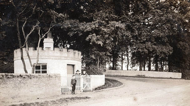
The land to the east of the house was glebe and owned by the Dean and Chapter of Canterbury, although in 1846 the drive from the east and narrow plantation with an entrance lodge were owned by Sir Philip Broke. A later undated postcard shows this as a circular lodge, suggesting it was built at the same time as the Hall in the mid-eighteenth century when ‘picturesque’ design and experimentation with landscape ancillary buildings was in fashion. It follows that the park and gardens were likely to have been designed with ‘picturesque’ principles in mind. Only areas to the west and immediately south were classed as parkland in the ownership of Sir Philip Broke. The tithe map of that year shows a farm complex north of the Hall and large square walled garden surrounded by trees to the west. It was not the fashion to have a farm so close to large country houses when Nathanial’s house was built, suggesting the farm was associated with the original courtyard house.
However, the farm had gone by the time of the 1884 OS map and been replaced by a lawned area dotted with trees as an extension of the pleasure gardens, which had also been extended to the east by this time. To give privacy from the road a shelterbelt of trees appears to have been newly-established along the southern boundary of the park. At the time the park to the west and south of the house was dotted freestanding and clumps of trees, but still with few trees to the east.
With the death of Sir George Nathanial Broke-Middleton Bt. in 1887, the Bramford Estate passed to his niece Frederica Mary, whose marriage to Rear-Admiral Sir Lampton Loriane meant it passed into the Lampton Loraine family.
Documents in the family’s archive suggest the house was tenanted during most of the second half of the nineteenth century. The 1861 census shows retired Liet.-Colonial Henry Phillipps and his family were residents of the house and a document dated 1874 was a lease for twenty-one years between Sir George and Charles Snell Paris, Esq. for Bramford Hall, gardens, cottages, but with only 1.2ha (3a) of parkland. However, it also included the shooting and fishing rights. George and Charles appear not to have taken up the lease because the following year Capt. Berkely Mansel was the tenant, and wrote to Sir George thanking him for alterations to the house in 1875.
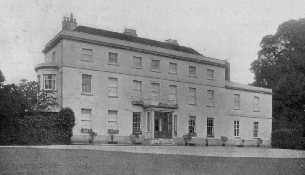
In 1890 a new tenant of the house, William Fraser, Esq., leased c. 9.7ha (24a) of parkland on a rolling yearly basis. Five years later Major-General John C. Russell was the tenant and specified various works that he required including updating the drainage and building a new bedroom. Obviously rather fond of his home, John went on to commission a number of photographs of the house, grounds and the wider estate.

John and his family continued to live at Bramford into the twentieth century, although by 1911 Sir Lampton Loraine, with his wife Frederica and children, had moved into the house they owned. After the death of Sir Lampton Loraine in 1917 the estate was inherited by their son Eustace Broke, although Frederica remained at Bramford and took over the management of the estate with her daughter, Isaura, who was to remain at Bramford Hall until she moved out when the house and park were requisitioned by the government during World War II.
Isaura died in 1947 and the family had no further use for Bramford so most of the house was demolished. The contents were sold in 1956, including wrought iron gates that formed part of the fencing between the park and garden. The remainder of the Bramford Hall estate of 507ha (1,253a) was sold in 1972 and much of the park became arable fields.
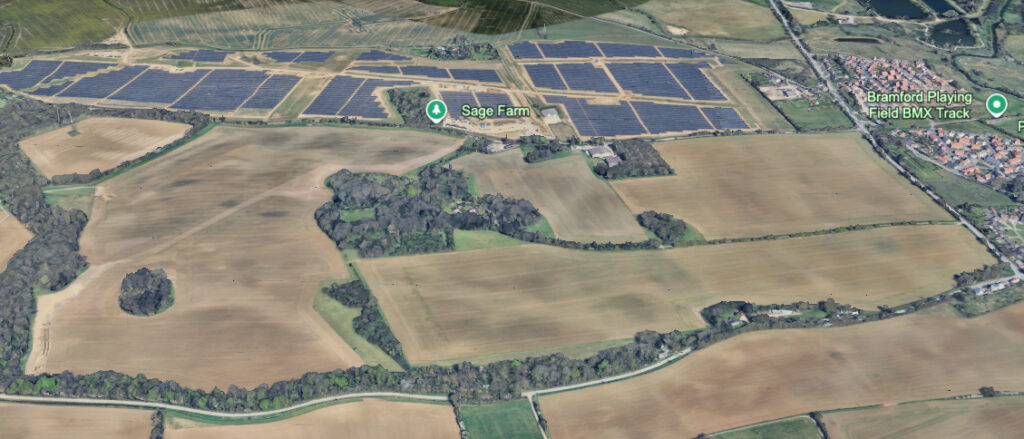
The remains of the house, which are now incorporated into a modern residence, the walled garden and the pleasure grounds were sold in 1974. The property survives today as an irregularly-shaped wooded enclosure surrounded by arable fields. Slightly deviating from its original eighteenth century course, the entrance drive to the property, now called ‘Hall Walk’, has been moved slightly to the north. As a result the lodge was obsolete and has been demolished. The remains of the walled garden survive in a very degraded form, which is now grassed over. The ‘ghost’ of the original path layout within the garden is still sometimes visible from the air.
Fields north of the original parkland are now the site of a large solar farm, which feeds into National Grid’s Bramford Substation that is close by to the west. Feeding into the substation, huge pylons associated with the proposed grid upgrade from Norwich to Tilbury are likely to be seen from the house site and will harm its setting.
SOURCES:
Blatchy, John and James, Jenny, ‘Beeston-Coyte Botanicus Gippovicensis’ in Suffolk Institute of Archaeology and History, Vol. XXXXIX Part 3, 1999.
Bramford Local History Group, The Book of Bramford: A Suffolk Parish and its People, 2012.
Burkes Peerage 1921.
Cromwell, Thomas Kitson, Excursions in the County of Suffolk, Vol. 1, 1818.
Copinger, W. A., The Manors of Suffolk Vol. 2, 1908.
Denny, Revd A. H. ‘Henry Davy 1793–1865’ in Suffolk Institute of Archaeology and History Vol. XXIX Part 1, 1961.
Roberts, William, Lost Country Houses of Suffolk, 2010.
Sedgewick, R. ed., The History of the House of Commons 1715–56, 1970.
The Gentlemen’s Magazine, 1830.
White, William, History, Gazetteer and Directory of Suffolk, 1844, 1855, 1874.
Census: 1861, 1891, 1901, 1911.
Maps:
Hodskinson’s Map of Suffolk in 1783.
1846 (surveyed 1846) tithe map and apportionment.
1884 (surveyed 1881) Ordnance Survey map.
1905 (revised 1902 to 1903) OS map.
c.1947 (revised 1938) OS map.
2025 Google Earth including data from Airbus.
Heritage Assets:
Suffolk Historic Environment Record (SHER) No: BRF 038.
Suffolk Archive (previously Suffolk Record Office):
(SA) P 471/1. Untitled map of the Bramford Hall estate and farms. Undated but probably 1728.
(SA) HA 61/436/898. Loraine family archive. Leases and other papers concerning Bramford Hall, bills and receipts for work done at Broke Hall and Bramford, 1847.
(SA) HA 116/5/16. Bramford Hall estate administration, 1856–1940.
(SA) HA 61/436/881. Contract of repairs and additions to Bramford Hall, 18 October 1865.
(SA) HA 61/436/871. Lease by Sir Geo. N. Broke-Middleton, Bt of Shrubland Hall to Charles Snell Paris, Esq…, 18 September 1874.
(SA) HA 61/436/887. Letters of Captain Berkeley Mansel (tenant of Bramford Hall) to Sir George. N. Broke-Middleton, 1875.
(SA) HA 61/436/1176. Agreement for 1 year @ £47.5 by Lady Loriane Broke of 7 Montagu Square to William Fraser, Esq of Bramford Hall…, 16 April 1889.
(SA) HA 61/436/882. Survey, specifications, contracts etc for work at Bramford Hall. 1895.
(SA) K 475. Albums of photographic negatives and photographs relating to Bramford Hall taken by William Vick, 1895–1902.
SRO(I) SC 063/2. Sales Catalogue, March 1953.
National Archives:
The 1939 Register.
Site ownership: Private
Study written: November 2025
Type of Study: Desktop
Written by: Tina Ranft
Amended:
