Parish: DALHAM
District Council: WEST SUFFOLK (previously Forest Heath)
TL 724 626
Not open to the public
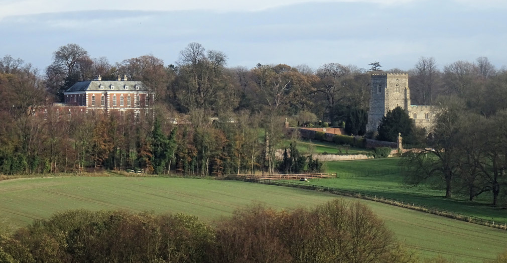
In a prominent position overlooking the valley of the River Kennett in this undulating chalk landscape, early-eighteenth century Dalham Hall (Grade II) is c. 9km (6mls) east of Newmarket and c. 5km (3mls) south of the A14 at Kentford. The house is close to the Church of St Mary (Grade I) in an isolated position north of Dalham village and east of the road between the village and Gazeley, a village close to the northern boundary of Dalham Hall’s landscape park. Moulton is to the north-west and Ashley to the west.
OWNERS OF DALHAM HALL AND PARK
The manor, originally known as Dalham with Dunstalls, was in the Stuteville family from the early-fifteenth century until 1697 when it was bought by Sir Gilbert Dolben. Soon after Simon Patrick the Bishop of Ely purchased the manor in 1702. With it came the Dalham Estate of c. 1,335ha (3,300a) and the manor house, which the Bishop replaced with a new house in 1704–5.
On the Bishop’s death in 1709 the estate passed to his son, also Simon, who sold it to John Afflick (d. 1718) five years later. The estate stayed in the Afflick family who made it their home until the beginning of the twentieth century when Sir Robert Affleck, Bart (1852–1919) was forced to sell the estate to pay outstanding loans in 1901.
Possibly due to its well-regarded game shooting, the buyer was Cecil Rhodes, the founder of Rhodesia, although he never took up residence because he died the following year, at which time it passed to his brother Francis William Rhodes. In 1928 Dalham Hall Estate was sold to Sir Laurence Philipps (1874–1962) a shipping magnate who established Dalham Hall Stud.
In 1981 the stud was sold to Sheikh Mohammed bin Rashid Al Maktoum, Ruler of Dubai and Prime Minister of the United Arab Emirates, who finally bought Dalham Hall and the remainder of the estate in 2009. In 2026 the whole estate continues to be owned by Sheikh Mohammed.
DALHAM HALL
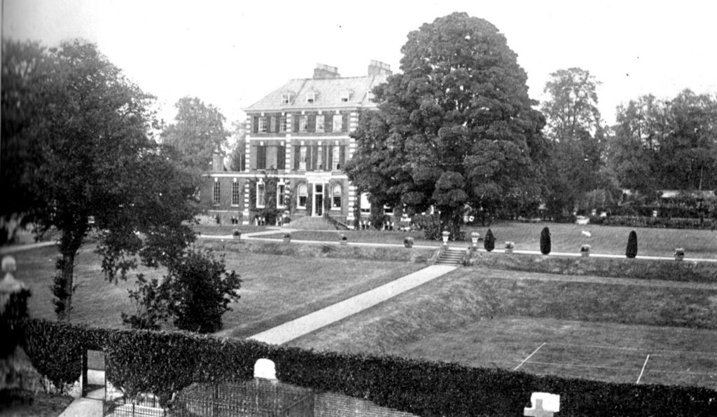
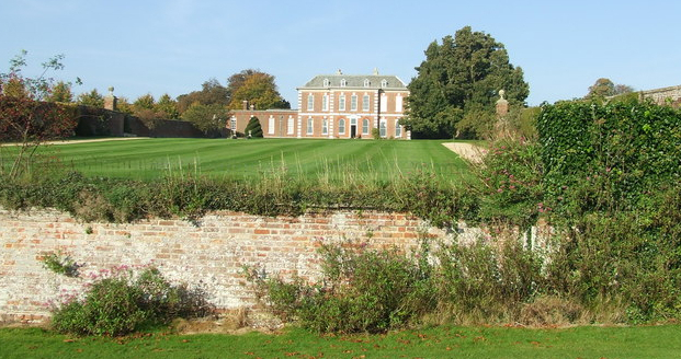
The present Dalham Hall was built on the site of the Stuteville’s earlier manor house, close to and retaining its medieval relationship with the church. The Queen Anne house originally had three-storeys plus attics.
Some alterations took place in the nineteenth century and Sir Robert Afflick had plans drawn up by C. E. Mallows to remodel the house, although these were not executed. A large extension with flat roof was added to the west by 1907. After a serious fire in 1954 the house was reduced to two storeys and re-roofed, albeit still retaining its classical appearance.
North-west of the house are the Baroque-style early-eighteenth century stables and coach house (Grade II) that are probably contemporary with the house. These were altered in the nineteenth and early-twentieth centuries. More recently the upper storey of the stables has been converted to residential properties. An early-eighteenth century service courtyard once lay directly south of the stables, although this had gone by the time of the 1883/4 OS map and replaced with service buildings north of the stables.
Edwin Lutyens was brought in to propose changes to the house in 1903, although these were not executed. Beyond the gardens to the west of the house, a group of estate cottages were built in the early-twentieth century and additional service ranges were added to the rear of the stables.
PARKLAND
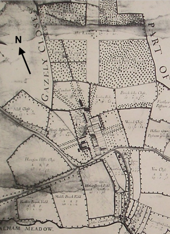
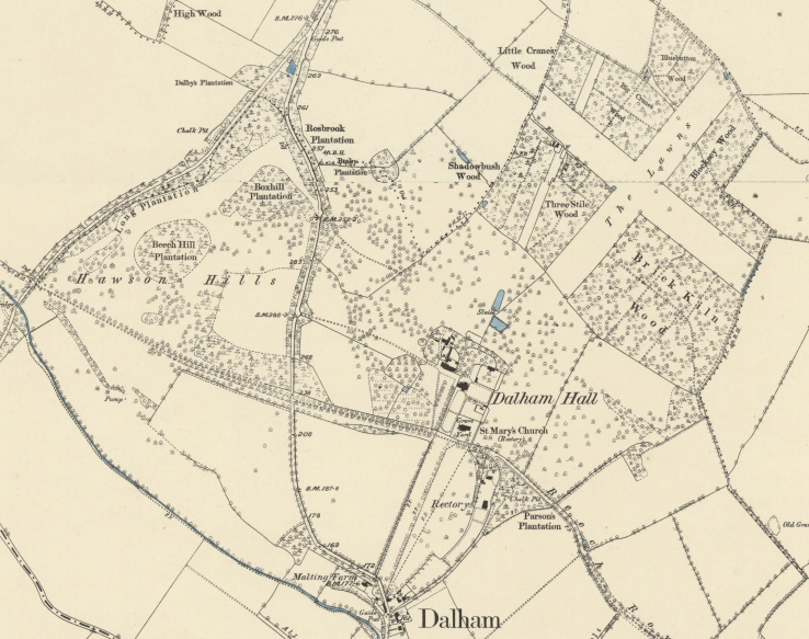
Soon after he acquired the Dalham Hall Estate, John Affleck commissioned Joseph Warner to produce a detailed map in 1716. Reflecting the landscape created by Simon Patrick the Bishop of Ely, this map shows the estate stretching east to west for over 5km (3mls) from Hargrave south-east of the house to Dalham with large fields enclosed by hedgerows and blocks of woodland. At this time a road ran from Dunstall Green to the south-east that passed in front of the church and house. It continued north-westward to Catford Bridge, the crossing point of the River Kennett by the road from Ashley to Gazeley. Part of this road formed the southern boundary of Dalham parkland.
Kirby’s 1736 map and Emanuel Bowen’s 1755 map of Suffolk mark the parkland, with Hodskinson’s 1783 map showing cruciform ‘lawns’ or parkland within the designed landscape park created in the seventeenth century. Its western boundary was, as on Warner’s earlier map, the road between Dalham village and Gazeley. However, in 1818 with the Parliamentary Enclosure of Dalham the east to west road was closed beyond the church to became a track within Dalham’s park with no public right of way. As a result of the Enclosure Act the village landscape was transformed by the amalgamation of small areas of land into larger fields. The park was extended by taking in land beyond the road from Dalham village to Gazeley. This took in Mawson Hills to terminate at the road from Ashley to Gazeley, with a shelterbelt of trees planted beside the road. Within the parkland further landscaping in the natural-style, fashionable during the eighteenth and nineteenth centuries, took place.
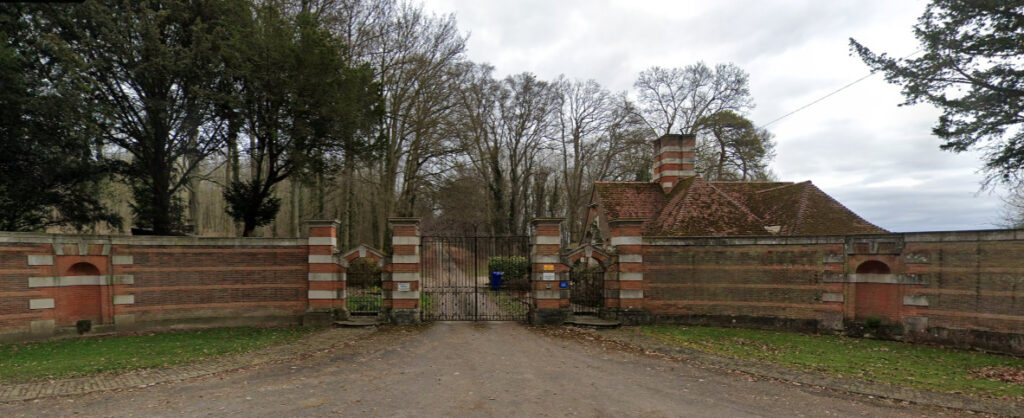
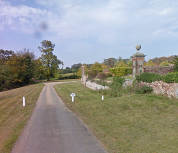
In 1903 Edwin Lutyens designed the new south-west entrance lodge and its screen walling (Grade II) to the drive along the route of the previously closed Dunstall Green to Moulton road where it meets the Ashley to Gazeley road south-west of the house. By this time the parkland had extended southward, taking in a field between the village and the church in which there was a pheasantry.
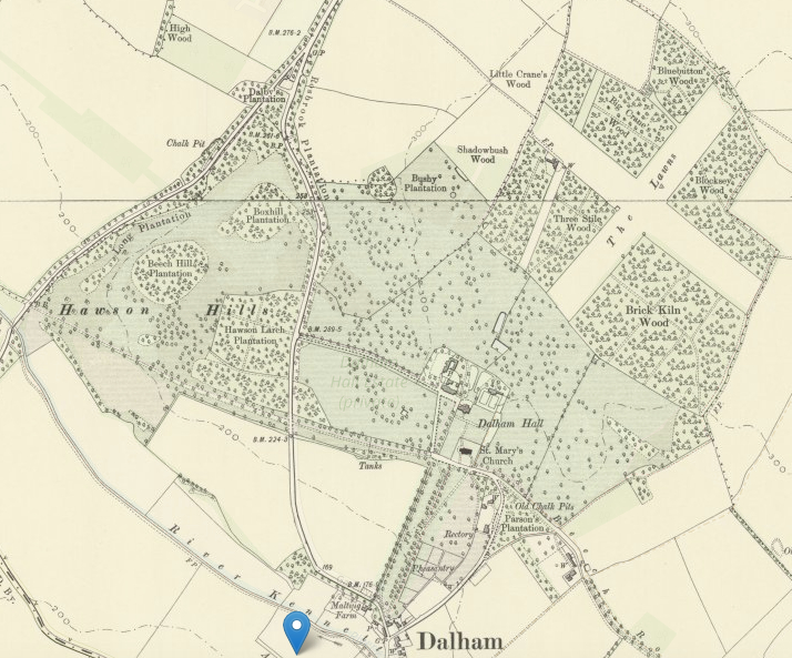
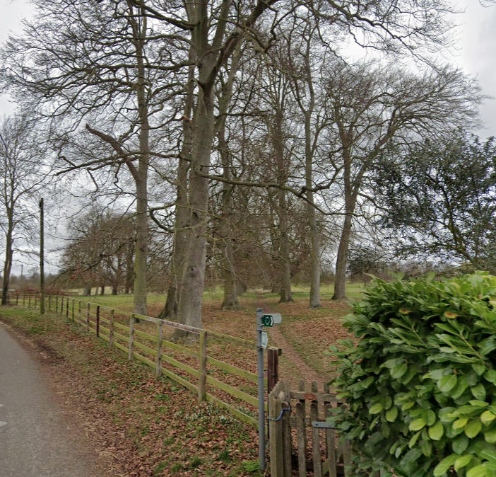
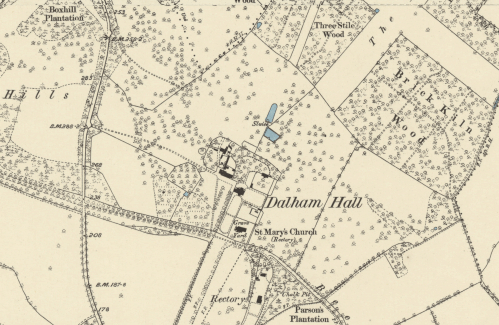
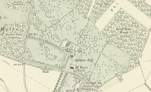
WOODS and TREES: The most prominent features on the 1716 map were, and continue to be, four woods north-east of the house enclosing ‘The Lawn’, a cruciform open area of parkland. The south-west wood named ‘Lawns Wood’ on the map had cruciform rides within it. On the 1883/4 OS map the four woods enclosing ‘The Lawn’ are named as ‘Three Stile Wood’ (south-western), ‘Brick Kiln Wood’ (south eastern), ‘Big Cranes Wood’ (north-western) and ‘Blocksey Wood’ (north-eastern). By this time the parkland had expanded further west to the road between Ashley and Gazeley and had a more natural appearance than a century earlier with parkland dotted with freestanding and clumps of trees. There were also belts of trees, especially along the road between Dalham village and Gazeley that cut through the parkland.
AVENUES and DRIVES: In 1716 double avenues of trees centred on the house radiated out to the east, west and north with further avenues fanning out from the northern avenue. Hodskinson’s 1783 map does not show the double avenues depicted on Warner’s map, although it is less detailed and they may have been omitted or it could indicate that these had been lost during the eighteenth century. However, a prominent avenue is shown along the route of the road leading through the field west of the Dalham to Gazeley road but at this time outside the area of the park.
The 1834 OS map shows two entrance drives into the park towards the house. One was off the old road south of the house. This joined a western entrance drive in front of the west elevation of the house before accessing the stables. The early-eighteenth century double avenues had gone by this time. In place of the lost northern avenue that gave an axial view and sightline towards the north, the central ride in ‘Three Stiles Wood’ had been widened to become another area of open parkland.
By 1883/4 a new southern single avenue towards Dalham village centred on the house had been planted south of the old east to west road. The present double avenue of horse chestnuts towards the village is probably an extensive replanting of this avenue.
Although none of the double avenues survive, the present west drive with its twentieth century single avenue marks the route of the western double avenue. This drive terminates at the road from Dalham village to Gazeley whereas the south-west drive continues beyond this road to the Ashley to Gazeley road.
CANALS: Centred on the north elevation of the house, two ornamental canals are shown on the 1716 map, the more northern flanked by the northern double avenue. A trapezoid-shaped pond lay at an angle between the two canals. The southern canal had gone by 1883/4, but the northernmost canal has survived. It is rounded at its northern end and today there are traces of a terrace that would have accommodated a walkway on its west side and possible on the east. These canals were part of the formal garden and landscaping by Simon Patrick the Bishop of Ely, fashionable in the late-seventeenth and early-eighteenth centuries, and contemporary with the creation of the avenues and axial drives. The angled pond also survives today.
PLEASURE GARDENS
Simon Patrick built fashionable terraced gardens to complement his new house at the beginning of the eighteenth century and may have retained some earlier walled garden enclosures from the previous manor house.
Early maps show the house surrounded by a number of garden enclosures, with the church in its own walled enclosure south-east of the house. Those enclosures that appear to be walled were immediately south of the house, to the north and north-east. In 1716 the enclosure east of the house was a bowling green but does not appear to have had an eastern wall, so giving views through the eastern double avenue to fields beyond. To its north the enclosure was the old kitchen garden and beyond that a walled orchard.
It is believed that a fence originally divided the southern walled garden enclosure into two sections. This was removed to double the ornamental area in the late 1700s and a wall was added to the east of the house to create another walled enclosure. This was probably around the time the eastern double avenue and bowling green disappeared. The southern enclosure and that to the east of the house had perimeter raised terrace walks that can clearly be seen in the 1902 photograph of the house (see above). These survive today, although more pronounced in the eastern enclosure.
The enclosed walled garden to the north-east is shown on the 1883 map, possibly as the kitchen garden with a lean-to glasshouse or orangery to the south side of the north wall. Alternatively it could have become another ornamental garden with a large summerhouse at its northern end. In 1883 there were slip gardens to east and west. By 1903 this walled garden had taken on a more formal appearance with wide perimeter paths and a central path to the building against the north wall suggestive of ornamental rather than productive use.
To the north of the house the 1883/4 map shows a terrace attached to the house with a mixed planting of trees with winding paths towards the parkland dotted with trees beyond. By 1903 this had been replaced by a more formal layout with a path on the central axis of the house.
The architect T. H. Mawson was consulted c. 1903 and produced plans for the garden ‘more in keeping with the spirit of a simple Georgian residence’ including a design for a summer house to terminate one of the raised garden terraces, although it is unknown if these were executed.
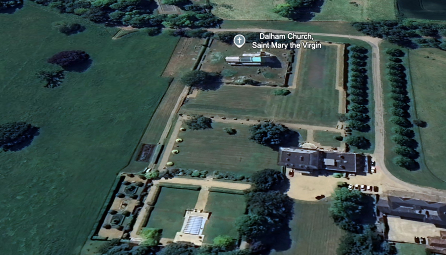
Today, the Queen Anne style of the house is reflected in the surviving eighteenth-century red brick walling to three sides of the southern garden enclosure with a return eastward dividing the churchyard from the east garden (Grade II). These form an L-shaped ornamental garden, which today is laid to grass with wide perimeter paths. The walling is c. 3m (10ft) high and ornamented with piers and cup-and-ball finials in limestone and runs southward from the house with a parallel section next to the church. These are joined by a low linking-wall, reduced to a ha-ha at the south end, but believed to have once had metal railings. The west wall in the southern enclosure is broken by wrought iron gates that open to the southern drive.
Once the kitchen garden, the north-eastern enclosure is now part of the ornamental gardens and has a summer house, not dissimilar to Mawson’s design, against the north wall that is fronted by a rectangular pond. Car parking and lawn has replaced the trees to the north of the house, which gives an open view to the grassed parkland with its scattered trees beyond, albeit recently there has been a general loss of tree density.
SOURCES:
Barker, H. R., West Suffolk Illustrated, 1907.
Birch, Mel, Suffolk’s Ancient Sites – Historic Places, 2004.
Copinger, W. A., The Manors of Suffolk, Vol 5, 1909.
Dalham Conservation Area Appraisal, Forest Heath District Council (now West Suffolk), May 2008.
Hussey, Christopher, ‘Dalham Hall, Suffolk’, Country Life 54 (September 1923).
Martin, Edward, ‘Garden Canals in Suffolk’ in East Anglia’s History: Studies in Honour of Norman Scarfe, 2002.
Mawson, Thomas, Hayton, The Art and Craft of Garden Making, 1912.
Page, Augustus, Supplement to the Suffolk Traveller [of J. Kirby] or Topographical and Genealogical Collections, Concerning That County, 1847.
White, William, Directory of Suffolk, 1844, 1874.
Williamson, Tom, Suffolk’s Gardens and Parks, 2000.
Nick Kingsley, https://landedfamilies.blogspot.com/2013/06/50-affleck-of-dalham-hall-baronets.html (accessed January 2021).
Maps:
1716 Dalham Estate map by Joseph Warner for John Affleck.
1736 Kirby’s map of Suffolk.
1755 Emanuel Bowen’s map of Suffolk.
1783 Hodskinson’s 1783 map of Suffolk.
1834 Ordnance Survey map.
1883/4 OS map.
1903 OS map.
Heritage Assets:
Suffolk Historic Environment Record (SHER): DAL 012, DAL 015, DAL 029.
Dalham Hall (Grade II), Historic England No: 1037703.
Church of St Mary (Grade I), Historic England No: 1037701.
Stables and Coach House 30m north-west of Dalham Hall (Grade II), Historic England No: 1192925.
West gate lodge to Dalham Hall with gates and walling, Ashley Road (Grade II), Historic England No: 1037695.
Three ranges of garden walling with linking ha-ha, piers and gates south of Dalham Hall (Grade II), Historic England No: 1037702.
Suffolk Archives (previously Suffolk Record Office):
(SA) E3/10/26/1. Title Deeds of Dalham Hall Estate, 1702–08.
(SA) HD714. Affleck Family, 1812–1847.
(SA) BRO/419/6. Printed sales particulars, Dalham Hall Estate, 1901.
Site ownership: Private
Study written: January 2026
Type of Study: Desktop
Written by: Tina Ranft
Amended: March 2026
