Parish: GROTON
District: BABERGH
TL 961 425
Not open to the public
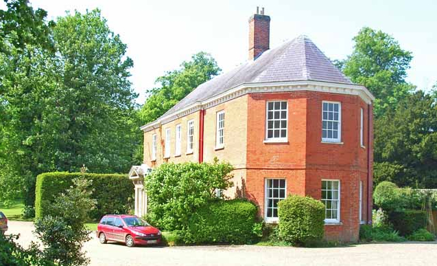
North of Boxford, Groton House (Grade II) is c. 9.5 km (6 miles) west of Hadleigh, c. 11km (7mls) east of Sudbury and stands at c. 65m (213ft) above sea level near a tributary of the River Box in a rolling arable landscape of chalky clay soils. The predominantly agricultural parish has scattered settlement in hamlets with isolated farms. Groton House is north of the centre of the small village of Groton, which consists a few houses near the fifteenth century Church of St Bartholomew (Grade I).
The large house was built in the early-eighteenth century in red brick, but with a much earlier seventeenth century core and is shown on Hodskinson’s 1783 map as an un-named building. It was owned and occupied by John Pytches Esq. from c. 1804 until his death in 1829. At the time it appears to have been known as ‘Groton Great House’.
It was bought in 1830 by Revd George Augustus Dawson, son of Thomas Dawson of nearby Edwardston Hall. George married Louisa, co-heiress of Sir Thomas Pilkington, Bart of Yorkshire and it stayed in the Pilkington Dawson family until the mid-twentieth century.
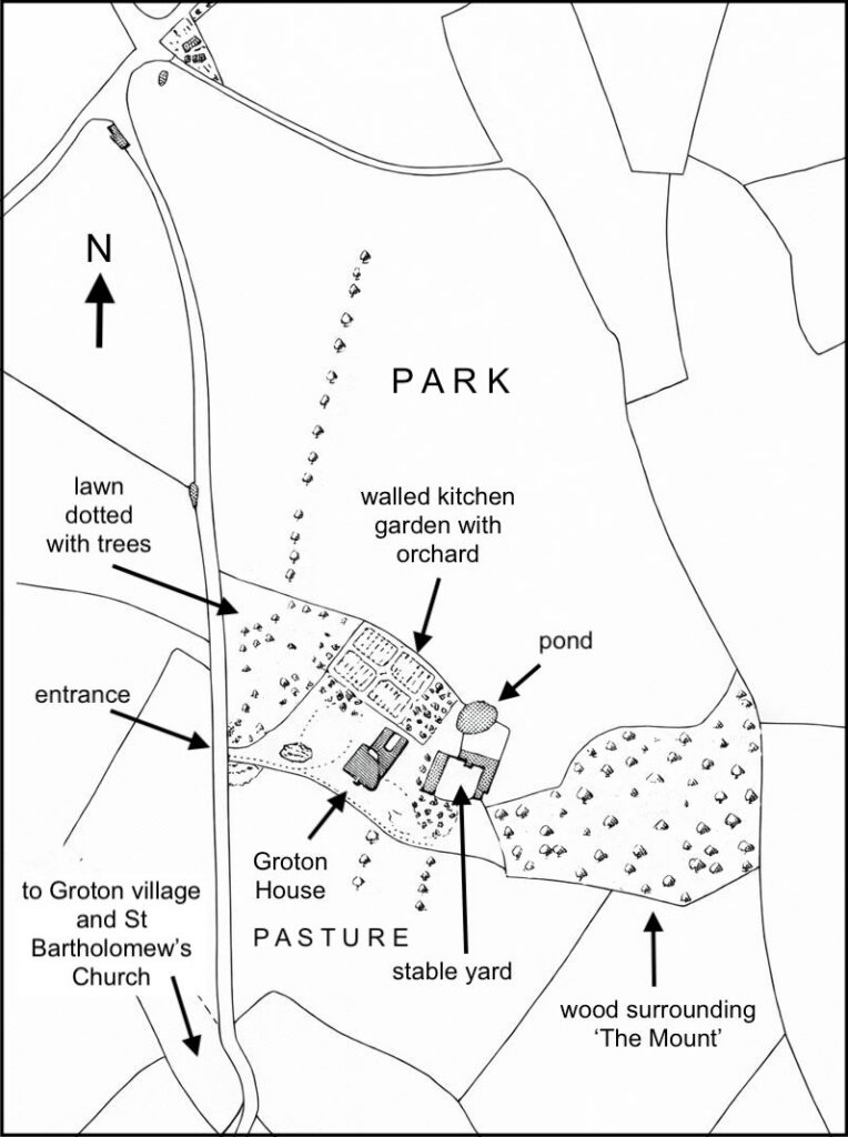
By the time of the 1838 tithe map, when it was owned by Revd George Augustus Dawson, Groton House had a small park north of the house. The main garden elevation faced south-west to overlook a small lawn and pasture beyond. The stable yard was to the east and a rectangular walled garden immediately north of two service wings attached to the rear of house. This garden was divided into four segments by cross-paths with a perimeter path plus an orchard within the walls. A large oval pond lay north of the stables with two small ponds in the pleasure gardens. These gardens wrapped around the house to the east, south and west. To the east there was a lawn with a clump and belt of trees hiding the stable yard. To the south of the house there was lawn and the west area of garden had a lawn dotted with freestanding trees bounded by the road to the west that leads south into Groton village.
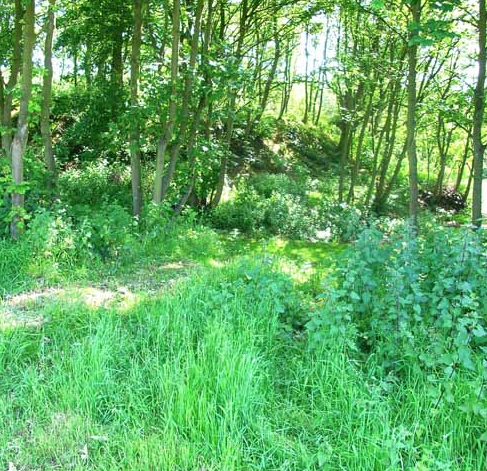
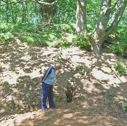
A surviving wood and mound called ‘The Mount’ was east of the stables. A 1798 estate map shows this belonged to Sir William Rowley of Tendring Hall, Stoke-by-Nayland, but was incorporated into Groton Park by the Revd George Augustus Dawson before 1838. Within the wood there is a large surviving mound known as Pitches (Pytches) Mount. It is c. 61m (200ft) in diameter at the base rising to 6m (20ft) high. Now a Scheduled Ancient Monument, it is believed to be a Norman ring motte and was once surrounded by a ditch. Its top has been excavated and a ‘ramp’ added on the north side, perhaps in the early-nineteenth century and probably by Revd George Augustus Dawson to form a garden feature.
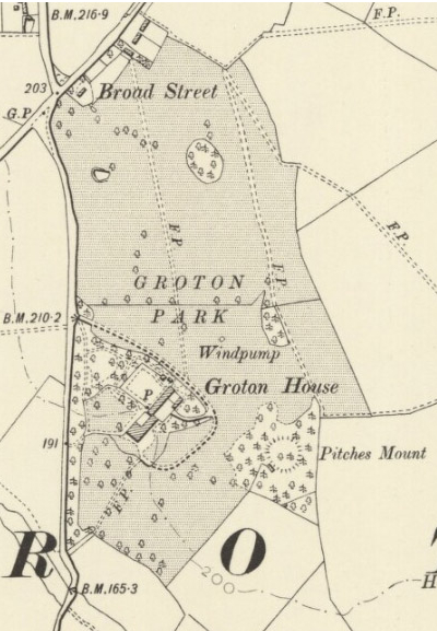
By 1885 the drive for Groton House had moved further north to sweep southward and curve around an area of garden to arrive at the eastern elevation of the house. With more detail, the 1905 OS map suggests there was an earthen bank or ha-ha beside the drive, which is confirmed by a postcard dated 1907 showing the garden front of the house with a bank and ditch marking the boundary of the pleasure grounds and parkland beyond. By this time the original stable block had been demolished and a new stables/coach house had been built attached to the walled garden in the position of the old orchard. At the southern end of the north wall of the walled garden there was a recess in the wall with two lean-to glasshouses.
In 1916 the house is said to have stood in a c. 20ha (50a) park, although it is believed that it was not lived in for most of the following sixty years.
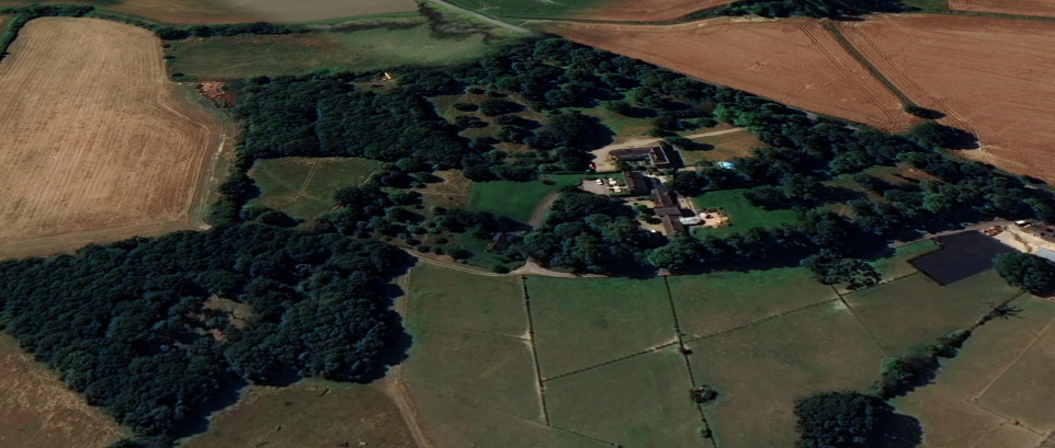
Much of original large house burnt down in 1981 and it was rebuilt to a much-reduced size and the associated land was divided-up. Groton House revived the earlier entrance, shown on the 1838 tithe map, to create a separate drive, its gardens to the west and south plus the southern parkland. At about the same time a large property called ‘Hunters Park’ was constructed, taking the drive and northern parkland. This partly became paddocks for horses housed in a new stable yard and is now in separate ownership with the rest continuing to be parkland but now named ‘Hunters Park’. A further property on the footprint of the old stables/coach house called ‘The Lodge’ shares the northern drive with Hunters Park and owns the parkland to the east of the site.
When Groton House was sold in 2018 it had c. 2.5ha (6a) of grounds, including the original western garden area and site of the walled garden plus the south garden with a lawn dotted with trees and some woodland. It is unknown if any of the walls of the walled garden survive.
SOURCES:
Burke, Sir Bernard, A Genealogical and Heraldic History of the Landed Gentry of Great Britain and Ireland, 1862, 1879, 1906, 1915.
Copinger, W. A., The Manors of Suffolk, Vol 1, 1905.
Kelly’s Suffolk Directory, 1916, 1922, 1928.
White, William, History, Gazetteer, and Directory of Suffolk, 1844.
http://www.suffolklandscape.org.uk/landscapes/Ancient-rolling-farmlands.aspx (accessed March 2021)
Groton Parish Website https://groton.onesuffolk.net/ (accessed February 2026).
https://www.rootschat.com/forum/index.php?topic=561976.9
Census: 1881, 1911.
Maps:
1783 Hodskinson’s Map of Suffolk in 1783.
1838 (surveyed 1838) tithe map and apportionments.
1885 (surveyed 1885) OS map.
1905 (revised 1902) OS map.
1927 (revised 1924) OS map.
1948 (revised 1938) OS map.
Heritage Assets:
Suffolk Historic Environment Record (SHER): GRT 001.
Groton House (Grade II), Historic England No: 1351465.
Church of St Bartholomew (Grade I), Historic England No: 1194685.
Pitches Mount. Historic England, Scheduled Ancient Monument No: 1006007.
Suffolk Archives (previously Suffolk Record Office):
(SA) EF 503/5/1/829. Cow shelter, Groton House, Groton for Miss E. Dawson, January 1948.
Site ownership: Private
Study written: February 2026
Type of Study: Desktop
Written by: Tina Ranft
Amended:
