(now known as Old Buckenham Hall School)
Parish: BRETTENHAM
District: BABERGH
TL 957 529
Not open to the general public
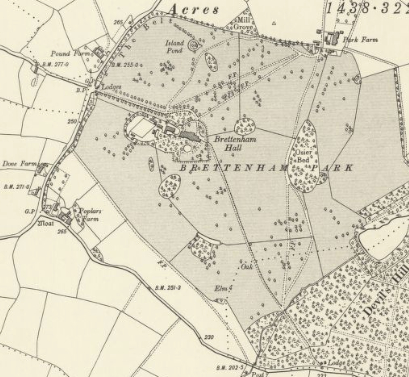
On the central Suffolk clayland plateau, Brettenham is an agricultural parish with dispersed farmsteads of mediaeval origin. Brettenham Hall and Park, now known as Old Buckenham Hall School (Grade II*), are south of the linear village of Brettenham, c. 9.5km (6mls) south-west of Stowmarket and c. 6.5km (4mls) north-east of Lavenham. There are small pockets of ancient woodland in the parish at Knightshill Grove, Morieux Wood to the west, Ram’s Wood to the north and Oak Grove Wood to the south-east of the Brettenham Hall site.
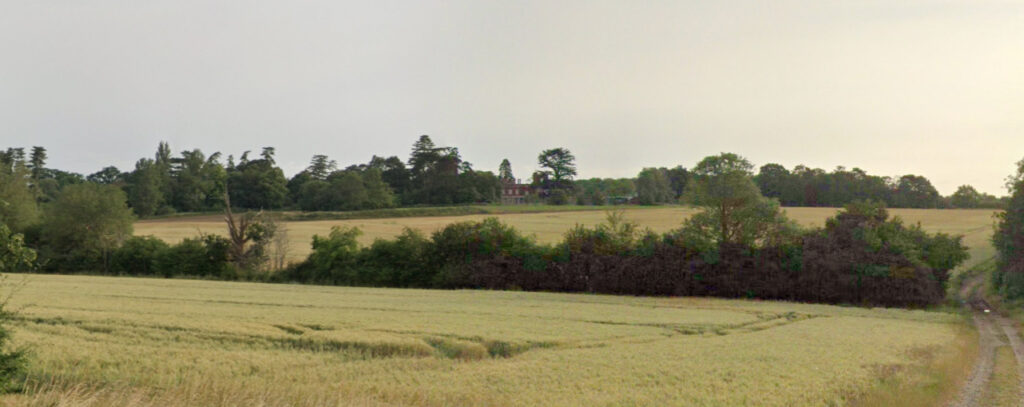
The Hall stands on a south-sloping site c. 1.6km (1ml) south of the fourteenth century Church of St Mary the Virgin (Grade I). The River Brett rises in the park and forms part of the boundary between the parish of Brettenham and its neighbour, Hitcham to the east. The river continues southward before joining the River Stour.
OWNERS AND OCCUPIERS OF BRETTENHAM HALL AND PARK
William Sampson is said to have been given Royal permission to establish a hunting reserve on his land in 1247, although there is no known documentary evidence to establish if it included the Brettenham Hall site or the lands he held to the west and north-west stretching from Thorpe Morieux to Ryece Hall Farm. The Sampson family continued to live at Brettenham until the fifteenth century when they inherited the Fellbrigge estates and moved to Playford near Ipswich. Control of the Brettenham estates stayed in the hands of the Sampsons until c. 1512 when, without a male heir, it passed through the female line to Thomas Felton.
In the early 1600s Brettenham was bought by Thomas Cutler, a wealthy Ipswich merchant who sold the Brettenham manor to Edward Wenyeve in 1631. Soon after, having kept the land associated Brettenham Hall, Edward built the present mansion and possibly established the first park around the house.
The Brettenham Estate stayed in the Wenyeve family until, through marriage, it passed to Colonel John Camac who rented out the Hall, including for a short period to Joseph Bonaparte, the ex-King of Spain and Naples and brother of Napolean. The Camac family owned the whole estate, which included land in the neighbouring parishes of Hitcham and Kettlebaston, during the 1840s.
The tithe apportionment of 1844 records William Camac as resident and owner of the Hall plus some clumps of woodland within the park, while John Camac held on to the majority of the parkland. However, in the same year William White in his History, Gazetteer, and Directory of Suffolk reported that the house was only occupied by a servant with the estate owned by the trustees of the late John Camac, Esq., presumably John had died earlier that year. There followed protracted legal arguments regarding the estate that were considered by the Wills and Probate Prerogative Court of Canterbury. Eventually John’s will was proved in 1848 and the court ordered the property to be sold.
Two years later the estate of 708ha (1,750a) was bought by Joseph Parker but sold ten years later to Thomas Bartholomew Beale who was High Sheriff of Suffolk in 1874. Thomas carried out improvements to the estate including building a new model farm on the edge of the park to the north-east of the house.
Thomas Courtney Theydon Warner purchased the estate c. 1902, including its 60.7ha (150a) park. Photographs from the Walton Burrell Archive held by Suffolk Archives from the following period record the house and park being used as a Red Cross hospital during World War I.
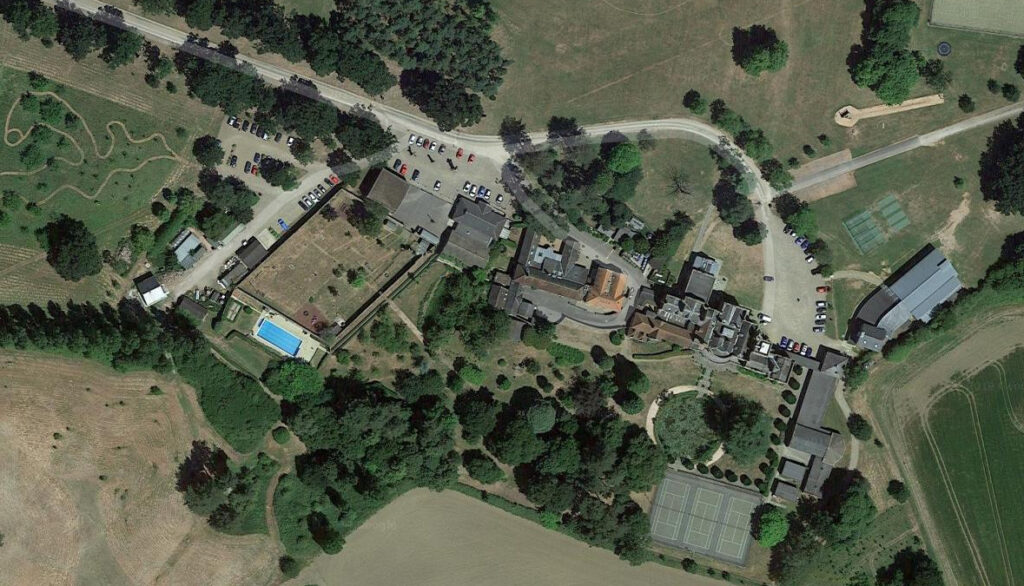
The Brettenham Estate stayed in the Warner family until 1956 when it was broken up and the house and parkland were sold to Old Buckenham Hall School, who were replacing their previous school buildings in Moreton, Norfolk that were lost to a fire. The school continues to thrive on the site as an independent preparatory school.
BRETTENHAM HALL
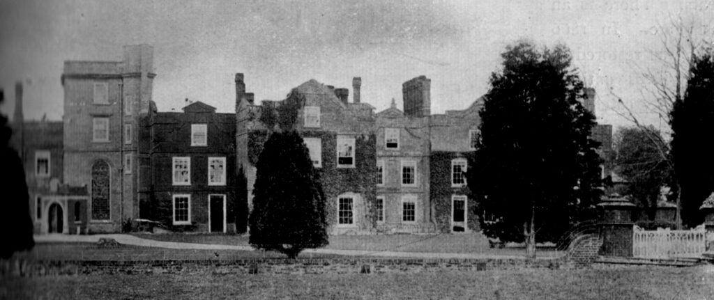
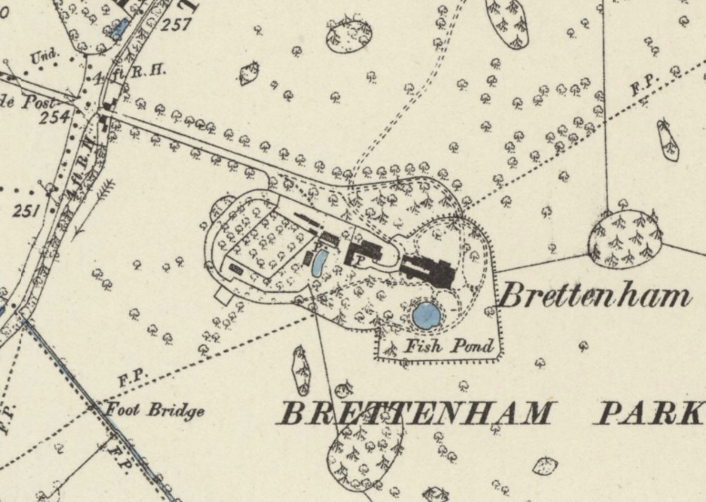
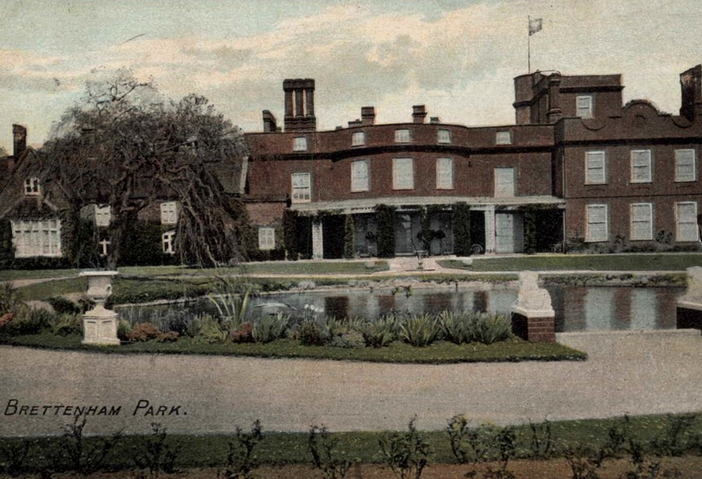
Brettenham Hall is a large brick mansion built by Edward Wenyeve c. 1635, possibly on the site of an earlier sixteenth century house. The present north front with parapet and Dutch gable may be a survival from this seventeenth century period. It was extensively altered and extended by Joseph Camac during the early-nineteenth century with a view to renting it out. An east wing and tower were added in 1903, soon after Thomas Warner bought Brettenham Park. The building was converted for use as a school when it was bought by Old Buckenham Hall School, although most of its historic fabric has been maintained, with new attached wings and separate school buildings built near the house.
LANDSCAPE PARK
Although likely to be of a much earlier date, possibly contemporary with a sixteenth century house, Hodskinson’s 1783 map of Suffolk shows an almost circular park bounded by roads to the north, west and south and covering land in the neighbouring Hitcham parish. The house stands towards the west edge of the park.
Tom Williamson writing in Suffolk Gardens and Parks suggests the house standing in this position within a lozenge-shaped enclosure of pleasure gardens, yards and service buildings could have been influenced by Lancelot ‘Capability’ Brown’s work during the 1760s at Branches Park on the west side of the county. If this were the case it would have been the Wenyeve family who originally created the enclosure within the landscape park.
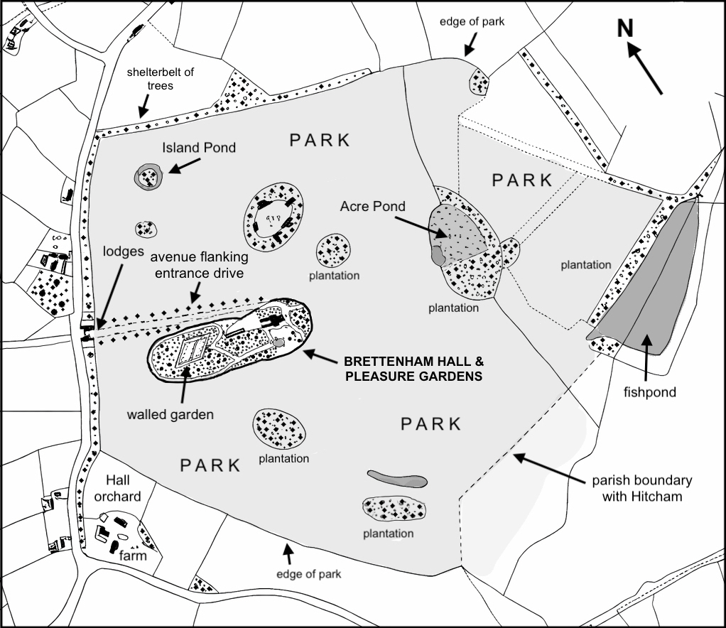
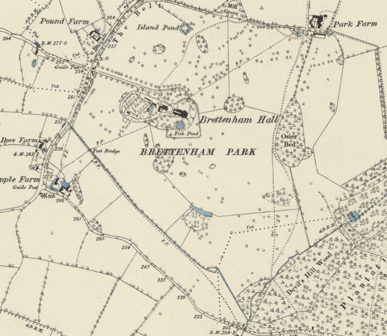
In 1844 the park covered 53.8ha (133a) and the tithe map of that year shows shelterbelts of trees, particularly to the west and north, with a few circular or oval clumps of trees scattered throughout. One unusual oval-shaped clump to the north of the house shows an outer ring of trees with an open interior edged by five buildings. Called simply ‘plantation’ on the tithe apportionment, the irregular positioning of the buildings is unlike a small ‘secret’ garden and more suggestive of use related to bird rearing for the shoot or kennelling for the hounds of the hunt. Further north the tithe map shows ‘Island Pond’, a surviving isolated circular moated island. To the south there was a long, thin pond backed by a plantation of trees that would have been visible from the house and therefore acting as a visual focal point to be viewed across parkland.
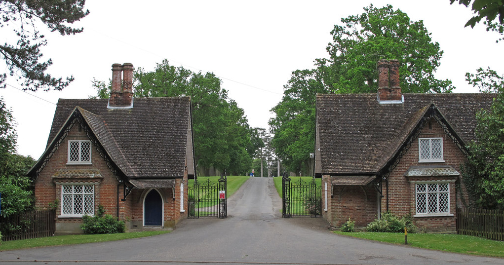
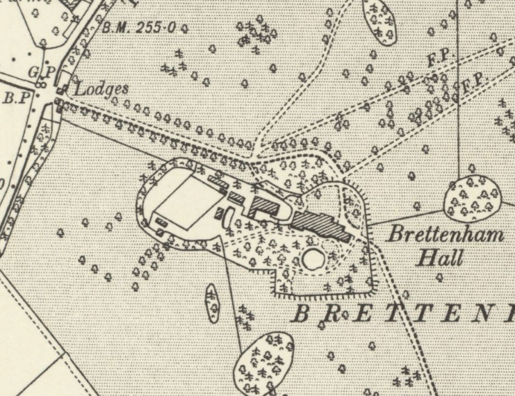
At this time a surviving avenue of oak trees lined the western drive flanked by two lodges and gates (Grade II) at the entrance and dates the construction of the red brick lodges to before 1844. They were most likely the work of Joseph Camac when he made extensive alterations to the Hall earlier in the century. Augustine Page writing in 1847 described the house as ‘pleasantly situated on a gentle elevation in a small but well wooded park, in which are several venerable oaks’.
By 1884 the oval ‘plantation’ with buildings shown on the tithe map to the north of the house had gone leaving just a group of freestanding trees in the park. Thomas Beale’s new model farm on the north-east edge of the park replaced the ancient moated farmhouse, farm buildings and orchard that are shown on the tithe map south-west of the Hall, today known as ‘Popples’ (Grade II*). A track from the new farm led south-eastward passing through Devil’s Hill Wood to a further entrance and surviving lodge, known as ‘Hitcham Lodge’ (Grade II), on the road to Hitcham, now called Bury Road.
Few major changes took place in the park over the next two decades. An additional footpath linking Park Farm to the Hall and another from the house to the south-east entrance off the Hitcham road had been established by 1905. Writing in 1907, H. R. Barker described the park as covering 60.7ha (150a).
Today part of the early parkland survives, although some fields to the south have been converted to arable and to the north-east the parkland has been replaced by the school’s playing fields. During the twentieth century a subsidiary drive linking the house to the village had been created by upgrading existing footpaths/tracks that passed Park Farm and building a new entrance lodge at the southern end of the village. More recently an avenue of trees has been planted along its route. The western drive and avenue of oaks still present a dramatic arrival to the Hall and a number of trees of various ages within the boundaries of the old park survive including Lime, Plane, Beech, Oak, Ash, Maple, Walnut, Horse Chestnut, Robinia, Corsican Pine, Monterey Cypress, Douglas Fir and Norway Spruce.
PLEASURE GARDENS
When owned by the Wenyeve family, Hodkinson’s 1783 map roughly marks the west drive leading to a circular feature representing Brettenham Hall site and its garden enclosure.
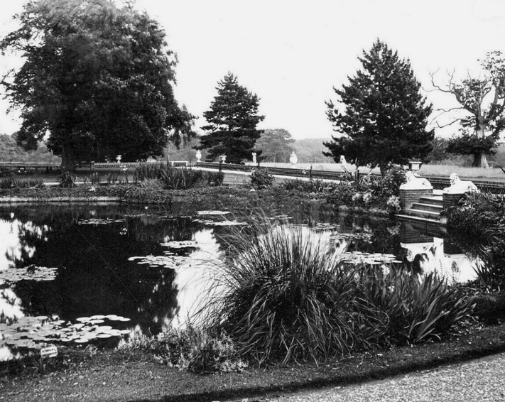
The 1844 tithe map gives more detail and shows that the house, walled garden, yards and service buildings lying within a lozenge-shaped enclosure of pleasure gardens. This is similar to the layout at Branches Park, and thus probably dating to the late-eighteenth century. Paths are shown leading from the house through tree-studded pleasures grounds, including a surviving large circular ornamental pond, to enter the surviving kite-shaped walled garden, again not unlike Lancelot Brown’s work at Branches Park where the angles are directed towards the compass points so that each wall benefited from as much sun as possible.
By 1884, when owned by Thomas Beale, the pleasure grounds had been extended outward into the parkland to the south and east with ha-has marking their boundary with the parkland. A further ha-ha edged part of the main drive closest to the Hall.
An undated photograph, probably taken in the early-twentieth century, from the Spanton Jarman Photographic Negatives Collection shows the south garden elevation of the house with slightly protruding bowed frontage and small terrace giving way to a gently-sloping lawn down to a gravel path and further lawn surrounding a circular ornamental pond. Centred on the bowed section, a sloping path has a feature central sundial. The outline of empty formal flowerbeds and small wheelbarrow can be seen, suggesting the beds were in the process of either being created or, more likely, replanted.
Held by Suffolk Archives, a series of photographs taken at the Hall when it was a Red Cross hospital during World War I show wounded soldiers on steps leading down to the southern garden, seated around the round ornamental pond and beside the huge leaves of a Gunnera plant.
Few changes to the pleasure gardens took place over the following four decades until it became Old Buckenham Hall School. Today tennis courts and modern school buildings are now on part of the original pleasure gardens around the house. The circular pond survives and there are paths winding their way through the wooded garden towards the uncultivated walled garden.
SOURCES:
Anon, A Concise Description of Bury St. Edmund’s: And Its Environs, Within the Distance of Ten Miles, 1827.
Anon, Living in Brettenham, created 2006, updated 2012.
Barker, H. R., West Suffolk Illustrated, 1907.
Betham, Revd Charles Jepson, ‘Brettenham and the Wenyeve Family’ in Suffolk Institute of History and Archeaology, Vol. IX, Part 1, 1895.
Birch, Mel, Suffolk’s Ancient Sites Historic Places, 2004.
Brettenham Parish Plan. Report & Action Plan, 2005.
Brettenham Conservation Area Appraisal, Babergh District Council, 2013.
Burke, Sir Bernard, A Genealogical and Heraldic History of the Landed Gentry of Great Britain and Ireland, Vol. 1, 1879.
Copinger, W. A., The Manors of Suffolk: The Hundreds of Carlford and Colneis, Cosford and Hartismere, 1909.
Kelly’s Handbook of the Titled, Landed and Official Classes, 1895, 1922.
Marjoram, Malcolm, ‘Brettenham – Its History’ in Brettenham Parish Plan: Report and Action Plan 2005.
Page, Augustine, Topographical and Genealogical, The County of Suffolk, A Supplement to the Suffolk Traveller (of J. Kirby), compiled 1811 and published in 1847 by Page, Joshua.
Walford, Edward, The County Families of the United Kingdom, 1894.
White, William, History, Gazetteer, and Directory of Suffolk…, 1844.
Williamson, Tom, Suffolk’s Gardens & Parks, 2000.
https://brettenham.onesuffolk.net (accessed March 2019).
http://www.suffolklandscape.org.uk/landscapes/Ancient-rolling-farmlands.aspx (accessed March 2019).
https//hitchamsuffolk.org.uk/history/ (accessed March 2019).
Bury Past & Present Society. https://www.burypastandpresent.org.uk/gallery-viewer/?ref=K505/2339 (accessed August 2025)
Census: 1851, 1861, 1871, 1881, 1901
Hodskinson’s Map of Suffolk in 1783.
1844 (surveyed 1844) tithe map and apportionment.
1884 (surveyed 1883 to 1884) Ordnance Survey map.
1905 (revised 1902) OS map.
Heritage Assets:
Suffolk Historic Environment Record (SHER): BTT 005, BTT 009, BTT 0012, BTT 014, BTT 015, BTT 051.
Old Buckenham Hall School (Grade II). Historic England No: 1037349.
Church of St Mary the Virgin (Grade I). Historic England No: 1037350.
West Lodges and Gates to Brettenham Park (Grade II). Historic England No: 1285873.
Poplars Farmhouse, formerly listed as The Popples (Grade II). Historic England No: 1351456.
Hitcham Lodge, formerly listed as Brettenham Lodge (Grade II). Historic England No: 103734.
Suffolk Archives (formerly Suffolk Record Office):
(SA) HA 532/1 and /7. Title deeds of properties which became part of Brettenham Hall Estate, mainly Brettenham and Preston, 1726–1902.
(SA) HA 532/11. Brettenham Hall Estate. Conveyance subject to mortgage following Chancery decree to Joseph Parker.
(SA) K 997/70/18 and 19 (SA) K 997/71. Series of photographs from the Walton Burrell Archive, early 20th century.
(SA) EF 503/3/1/658. Alterations and additions, lodge cottages, Brettenham Park (Sir Edward Warner, BT), November 1945.
London Archives: City of London:
MS 11936/515/1061426. Records of Sun Fire Office: Insured: Col. John Camac, Brettenham Park, Brettenham Hall, Suffolk, 30 May 1827.
Site ownership: Private Educational Institution
Study written: March 2026
Type of Study: Desktop
Written by: Tina Ranft
Amended:
