Parish: BADLEY
District: MID SUFFOLK
TM 061 558
House not open to the public. Along Badley Walk there is a public footpath.
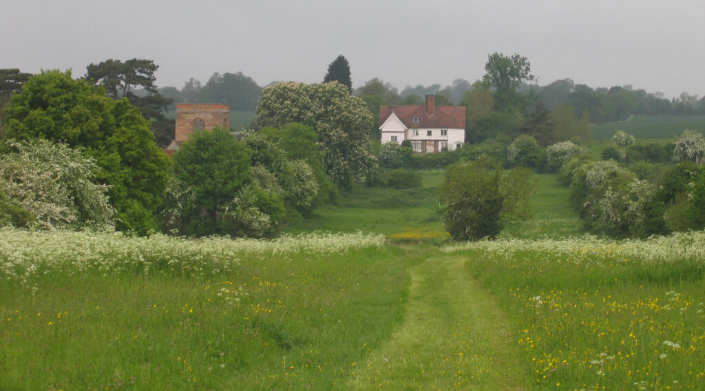
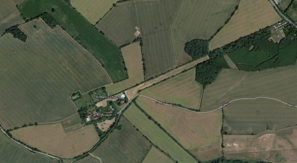
In gently rolling countryside with medium clay soils, Badley Hall (Grade II*) is c. 3.2km (2mls) south of Stowmarket at c. 45m (147ft) above sea level. Formerly a much larger house, it is part of a small settlement cluster including the mainly fifteenth century Church of St Mary (Grade I), but with a much earlier core. The site is close to a spring that feeds into the Bat River, a tributary of the Gipping River. It was once linked to the road between Stowmarket and Needham Market to the east by a 40m (131ft) wide formal approach avenue that was almost 1.6km (1ml) long, the vestiges surviving as Badley Walk. Remnants of ancient woodland are scattered around the parish such as Lower and Upper Badley Woods to the south-west and Keyfield Groves flanking Badley Walk.
OWNERS OF BADLEY HALL
The site is recorded in Domesday Book and in 1424 the manor of Badley was sold by Robert Mortimer to Edmund Alcock, who founded a Chantry in the church in 1492. At his death it passed to his daughter Margery who was married to Simon Poley (Pooley). When she died it passed to the Poley family who owned it for over a hundred years.
In 1707 it passed to Sir Edmund Poley’s sister Elizabeth who was married to Sir Richard Gipps of Horringer near Bury St Edmunds. When she died in 1715 the Badley manor passed to their son, also Richard Gipps, who sold it to the Crowley family of Barking Hall and London in 1735.
By this time a tenanted farm, through marriage Badley Hall Farm became the property of the Ashburnham family, large landowners in the area who added it to their Barking Hall Estate.
In 1832 William Mudd (c. 1789–c. 1857) rented the house and farmed the Badley Hall land. He was still at Badley in 1851 when the census records him as farming c. 166.7ha (412a) and employing sixteenth men. The Mudd family continued to rent Badley Hall Farm and expanded their holding by acquiring the c. 85.8ha (212a) Badley Green Farm, the farmhouse only a short distance south of Badley Hall.
The Mudd family were still at Badley in 1917 when Lord Ashburnham’s estate, including the Badley Hall and Badley Green farms, was for sale. The sales particulars list many other Ashburnham properties in the area such as Barking Hall, Combs Hall, Darmsden Hall, Badley Water Mill, plus numerous other farms and woods.
Eventually the estate was broken up and Badley Hall Farm was bought by William F. Mudd (c. 1868–1922) who was succeeded by Edgar Mudd. Edgar did not live at the Hall but employed William Woods as a resident farm bailiff.
Badley Hall Farm changed hands again and was acquired by William Hunt followed by Mr L. Scott in 1946. In 2026 it remains in the Scott family.
THE HALL AND ASSOCIATED BUILDINGS
Sir Edmund Poley (c. 1486–1548/9) is believed to have built the large timber-framed house on Badley manorial site sometime in the 1520s or 1530s. In 1674 it was recorded as having thirty hearths and must have been a large, high-status mansion, suitable for the needs of the influential Poley family. At this time the house had a courtyard plan and the main entrance is thought to have been to the east at the end of the wide formal approach avenue off the Stowmarket to Needham Market road, today known as Badley Walk. It is believed that the house was the same width as this formal avenue.
In 1703 it is said that much of the house was badly damaged in a great storm and appears to have been bought in 1735 by Ambrose Crowley in that state. An estate map of 1741 shows a large, quadrangular building and includes an illustration of the west front that shows the western range as a two-storey building plus attic. A low brick wall interrupted by gate post piers topped and decorative caps with wrought iron entrance gates that lead through an arch into the inner courtyard. It is believed this had become the main entrance after the storm damage to the eastern range.
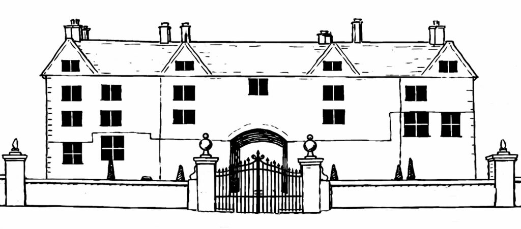
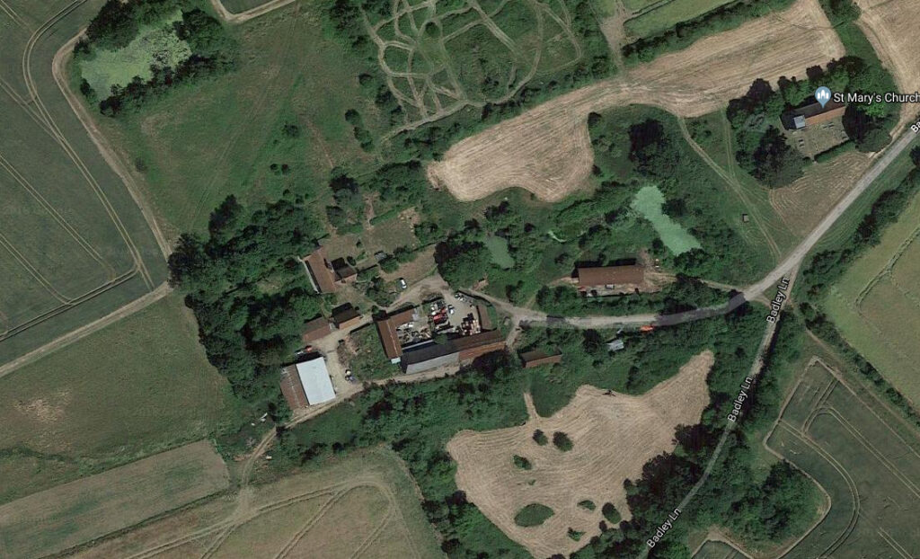
Like nearby Combs Hall, which was also bought by the Crowley family in 1735 and subsequently demolished c. 1755, the Crowley family had no use for such a large house at Badley, so what remained after the storm was further reduced in size. At least half was advertised for sale in the Ipswich Journal, March 2nd, 1759 as ‘the framework of a building about 60 feet [18.3m] long and 18 feet [5.5m] wide, the whole of good sound oak…’ together with doors and windows. It is believed this was the northern half of the western range that contained the great hall and parlour. What remains is just the south-west corner of the original mansion consisting service range, cross-entry with west porch and projecting east wing.
In addition to the much-reduced house, an early- to mid-sixteenth century bakehouse (Grade II) is 15m (50ft) to the south of the house survives and is often referred to as ‘The Cottage’. It is timber-framed with a tiled roof and red brick chimney that had an attic added in the seventeenth century and was remodelled during nineteenth century.
To the east is a rare Suffolk timber-framed, sixteenth century dovecote (Grade II). It is 5m (16.4ft) square with a tiled pyramid roof with a pair of triangular entries at the apex. Some repairs used narrow seventeenth century bricks and it has eighteenth or nineteenth century stable doors on the west side. There are remnants of dowels that supported the nests.
The range of farm buildings on the site includes an eight-bay, sixteenth century timber-framed and weather-boarded barn (Grade II*) with a fine example of a queen-post roof. A further four-bay barn of the same date re-uses earlier timbers and was converted into stables in the seventeenth century and remodelled in the nineteenth and twentieth centuries.
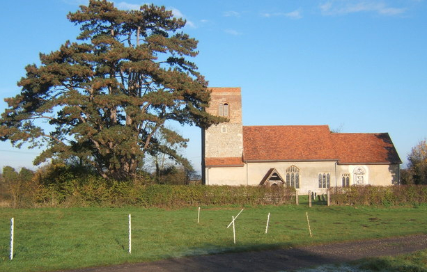
The Church of St Mary stands just east of Badley Hall beside Church Green and Badley Walk. It has a core dating to c. 1200, or perhaps earlier, but is mainly fifteenth century with an unmodernised eighteenth century interior that relies entirely on natural lighting with no heating or running water. It houses many monuments, memorial slabs and grave stones to the Poley and Mudd families.
Today the whole site of Badley Hall, including the farm buildings and church, are in Badley Church Green Conservation Area.
THE ENTRANCE APPROACHES
The original east elevation is believed to have been the entrance façade to early-sixteenth century Badley Hall as it fronts the former, grand approach avenue that is known as Badley Walk. The approach may be contemporary with the original house, or possibly later in the sixteenth century or early-seventeenth century.
The avenue is clearly shown on Hodskinson’s 1783 map of Suffolk indicating Badley Hall’s former high-status. It would once have been a long open greensward c. 40m (131ft) wide bounded by an avenue of trees, providing a statement of ownership and control of the surrounding land. It rises in height in its central section to pass between two mirror image groups of mixed woodland trees known today as Keyfield Groves. These include remnants of ancient woodland. It is believed that the full extent of the house once filled the width of the avenue, with the church just to its southern side.
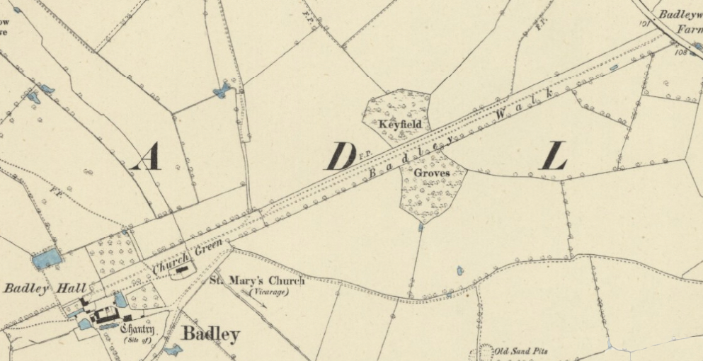
Along the western half of the avenue, elm hedges have replaced the trees, although the greensward survives as a wildflower meadow. The eastern half has become overgrown with blackthorn and other trees leaving only a walking track. Near the main road, its north-eastern end was in-filled with bungalows built in the 1920s by William Mudd, owner of Badley Hall at the time. This was said to have been a way to create work for local people in a time of economic depression. A footpath now runs the full length of the walk, branching off south to the church and north towards Combs. Today the whole of Badley Walk is in the Badley Church Green Conservation Area.
The 1741 estate map shows another avenue on the same axis to the west of the house and joining the lane leading north to Combs. This appears to have become the main entrance after the storm damage to the building in 1703 that especially affected the eastern range.
Today the main access to the house is from a gently-winding track through fields from the east. This also serves as a public footpath. It passes the church before branching off into the farmyard with the house beyond.
THE GARDENS
Originally the manorial site would have been surrounded by a number of defined enclosures. The remnants of an ancient moat surround the church on two sides and field boundaries suggest the ghost of enclosures to the north. On slightly higher ground, the rectangular pond to the north-west is said to be an ancient fish pond that was later converted to become a reservoir feeding water tanks in the basement of the house. It seems likely that its near proximity to the northern edge of the original Elizabethan mansion would have meant the pond had an ornamental role in its formal gardens.
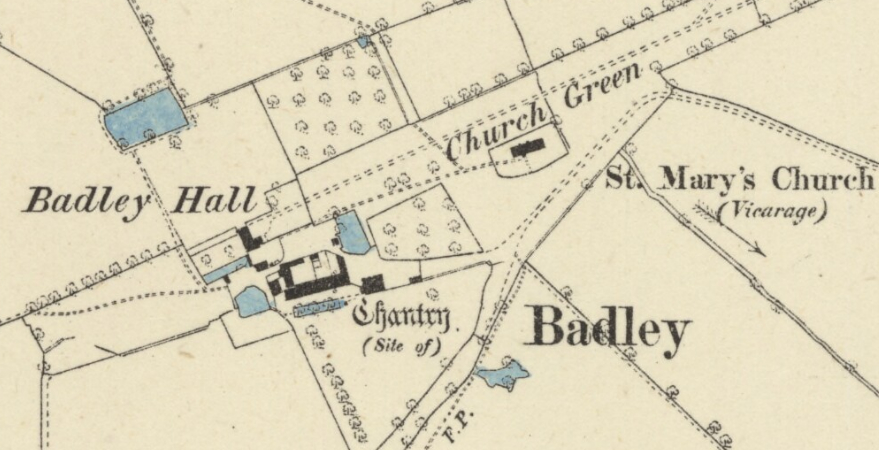
West of the house is a surviving garden enclosure formed by a low brick wall running parallel to the house elevation through which runs a wide flagged path c. 45m long (147.6ft). This is flanked by brick walls at right-angles to the house to an ornamental entrance gateway with tall pillars topped with globes. The gateway would have been centrally positioned on the west façade until the house was reduced in size c. 1759, thus now being off-centre and joining at its northern end. It is shown in the illustration from the estate map of 1741 and therefore dating it to the early-eighteenth century or earlier, when it was the home of the Poley family. It survives in a degraded state today. Also shown on the map is an ornamental ‘canal’ at right-angles to the house and flanking it to the south-west. This survives as an overgrown, brick-lined, rectangular pond 30m (98ft) x 8m (26.2ft) that is almost dry.
SOURCES:
Birch, Mel, Suffolk’s Ancient Sites Historic Places, 2004.
Copinger, W. A., The Manors of Suffolk, Vol. 2, 1905.
Kelly’s Directory of Suffolk, 1858, 1883, 1892, 1916, 1922, 1929, 1933, 1937.
Mid Suffolk District Council, Badley Church Green: Conservation Area Appraisal, 2012.
Mid Suffolk District Council, List of Buildings of Special Architectural or Historic Interest, 1986.
Martin, Edward, ‘Garden Canals in Suffolk’ in East Anglia’s History: Studies in Honour of Norman Scarfe, 2002.
Martin, E. and Oswald, A, ‘The House and Gardens of Combs Hall, near Stowmarket: A Survey by the Royal Commission on the Historical Monuments of England’ in Suffolk Institute of Archaeology and History Proceedings Vol. XXXVIII Part 4, 1996.
Lilian J., ‘Inventory of the Records, Deposited by the Suffolk Institute of Archaeology and History in Ipswich Public Library’ in Suffolk Institute of Archaeology and History Vol. XXIII, Part 3, 1939.
Sandon, Eric, Suffolk Houses. A Study of Domestic Architecture, 1977.
Suffolk, Eastern Division Poll Book, 1832.
Williamson, Tom, Suffolk’s Gardens & Parks, 2000.
White, William, History, Gazetteer & Directory of Suffolk, 1844, 1874, 1885.
http://www.suffolklandscape.org.uk/landscapes/Rolling-valley-claylands.aspx (accessed December 2018).
Badley – History of the Parish. http://maurice.toucansurf.com/badley.html#wa (accessed December 2018).
Census: 1841, 1851, 1861, 1871, 1881, 1901, 1911.
Maps:
1783 Hodskinson’s Map of Suffolk in 1783.
1839 tithe map and apportionment.
1884 (surveyed 1884) Ordnance Survey map.
1905 (revised 1903) OS map.
1928 (revised 1924) OS map.
2025 Google aerial map (Imagery ©2025 Airbus, Maxar Technologies, Map data © 2025).
Heritage Assets:
Suffolk Historic Environment Record (SHER): SHER No: BAD 008; BAD 009; BAD 010; BAD 022.
Badley Hall (Grade II), Historic England No: 1231083.
Church of St Mary (Grade I), Historic England No: 1231082.
Bakehouse 15 metres south of Badley Hall (Grade II), Historic England No: 1278291.
Dovecote 60 metres east of Badley Hall (Grade II), Historic England No: 1231084.
Barn 100 metres south-east of Badley Hall (Grade II*), Historic England No: 1231085.
Suffolk Archives (previously Suffolk Record Office):
(SA) HA1/D/A/1/8/4. Grant by Edmond Poley of Badley Esq. to Richard his third son, 1628.
(SA) HA1/DA2/10/1-8. Ashburnham Family Archives. Eighteen and nineteenth centuries.
(SA) HA1/G/A/1/2. Abstract of title of Mrs Crowley to Manors of Badley, Columbines, Badley Hall, Columbine Hall,…., 13 March 1741/1742.
(SA) P 638. Map for Ambrose Crowley of his Suffolk estate surveyed by William Collier, 1741. Original believed to be in private hands [Hew Stephenson of Columbine Hall].
(SA) HD 402/2/1917/6. Sales particulars for the Barking Hall Estate, including many other properties in the area such as Barking Hall, Combs Hall and Darmsden Hall, Badley Water Mill, numerous farms and woods. Sold by direction of Lord Ashburnham, (SA), 11 December 1917.
Site ownership: Private
Study written: April 2026
Type of Study: Desktop and site visit 2015
Written by: Tina Ranft
Amended:
