Parish: ACTON
District Council: BABERGH
TL 885 456
Site of business park
In gently rolling fields on the Suffolk clayland plateau, the site of Acton Place lies north-west of the village of Acton, c. 3.2km (2mls) east of Long Melford and c. 6.4km (4mls) north of Sudbury. It was once home to an early-eighteenth century mansion, landscape park, canal and pleasure gardens, which were progressively lost during the nineteenth and twentieth centuries. It has now been replaced by a business park with only part of the eighteenth century canal surviving.
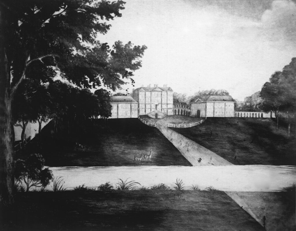
Robert Jennens, Esq., thought to be the son of an extremely wealthy Birmingham ironmaster, acquired the Acton Place estate in 1708 from the Daniel family, who had owned manors in Acton since the early-sixteenth century. Before Robert’s death in 1725 work began to build a great house, designed by the influential British architect James Gibbs, surrounded by a landscape park. Succeeding his father, William Jennens is recorded as an extremely wealthy man and, being a godson of King William III, would have had connections in the highest society. By the time of his death in 1798 the mansion was still not fully completed. An eighteenth century painting shows the house, flanked by two linked pavilions, with a grand flight of steps leading from an enclosed entrance courtyard. In front of the mansion there are deer grazing in the park that flanks the entrance drive. Trees surround the mansion on the other three sides. In the foreground, a canal is shown parallel to the house front, which is shown on both Hodskinson’s 1783 map and the tithe map of 1839 as lozenge-shaped and centrally crossed by the entrance drive. It seems likely it had been created when building work began on the mansion in the 1720s.
William Jennens died a bachelor well into his nineties and intestate. Legal action followed as to the rightful heirs and in 1816 the estate passed to the Hon. Richard William Penn Curzon, who was created Earl Howe five years later. By this time the mansion was described by Cromwell in his Excursions as presenting ‘a deplorable spectacle of desolation, and the approach to it could be traced only by the colour and height of the grass that had grown over the gravel’ and the gardens ‘had fared worse than the building, having been ploughed up and cultivated as a field’.
The majority of the mansion was demolished over a period from 1825 to 1844. The 1839 tithe map shows that the central block had gone by then, leaving just the pavilions left standing. The lozenge-shaped canal appears to have partly-silted up, although the drive and a semi-circular formal garden area, centred on the rear of the lost block, remained. This garden area gave access to a track lined with a row of trees, probably the remains of an avenue, that led out through a much-reduced area of parkland dotted with freestanding trees to the ancient woodland of Acton Wood. Here avenues spanned out through the wood from a circular clearing south-west of the mansion. One of the surviving pavilions was demolished soon after and in 1855 it was reported that only the service wing and some outbuildings were left.
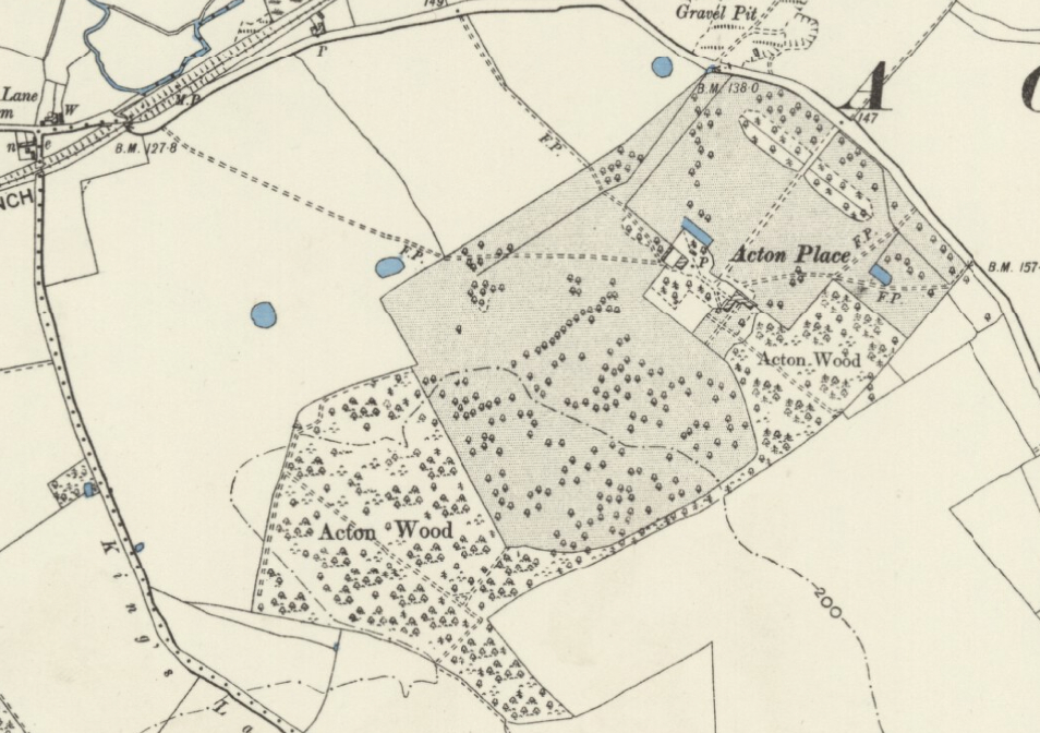
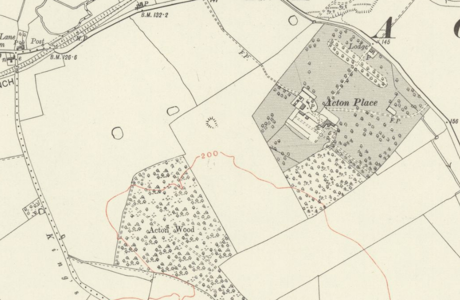
By the 1890s, when the house was tenanted, the surviving wing had been renovated and extended and a partly-walled kitchen garden was added within newly-created pleasure grounds. The parkland was extended by taking in some of the agricultural field to the south of the house and Acton Wood was extended in a strip to create a shelterbelt of trees along the park’s southern boundary that expanded into an additional area of woodland beside the gardens to the rear of the house. Giving privacy to the house from the road, a mixed planting of deciduous and coniferous trees had developed within the canal basin. Writing in 1907, H. R. Barker described Acton Place as ‘a fine mansion in an extensive park with many noble trees’ that are shown on the 1899 OS map dotted mainly in its southern section. The 1928 OS map shows the addition of an entrance lodge and a short avenue of trees flanking the drive, although the majority of the park had once more reverted to cultivated fields. The estate was requisitioned by the military in World War II and used as an army base and later a US military hospital.
Any house of this status would have had an icehouse and, although no known documentary evidence survives as to its whereabouts, a mound is marked on the 1928 map in a field due west of the house. Shown on previous maps as a clump of trees within the park with ponds nearby, although later ploughed out, this feature is a likely candidate for the lost icehouse.
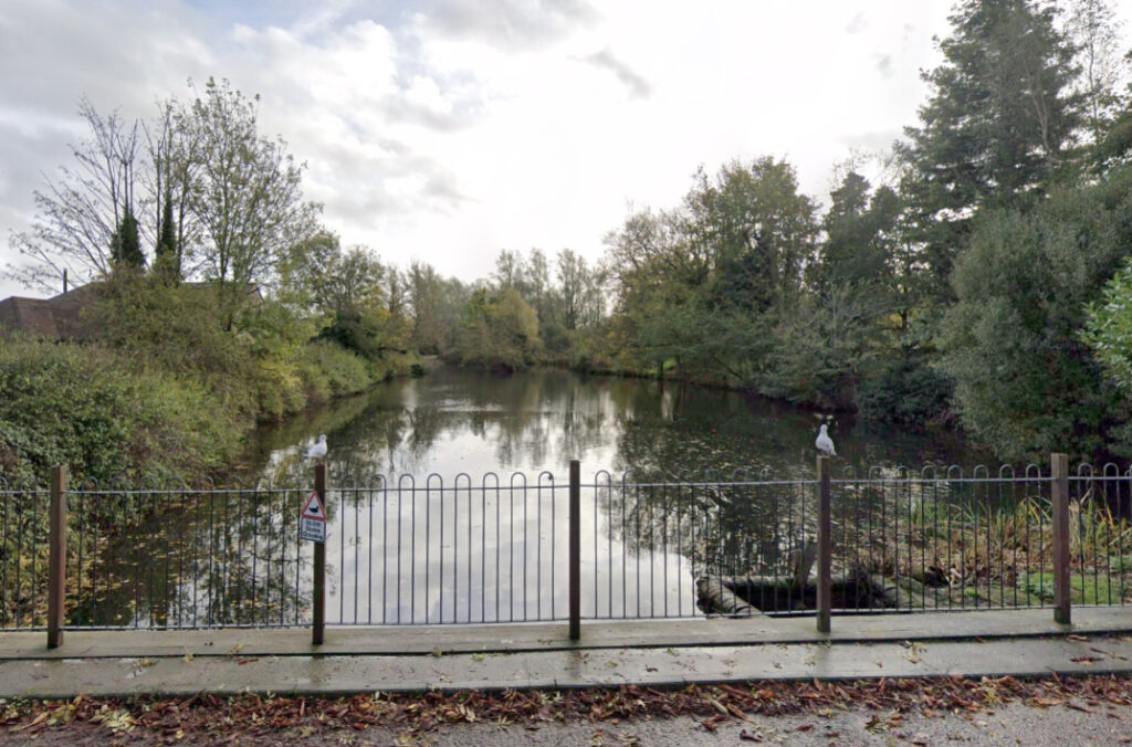
The house and gardens were demolished in 1961 to be replaced by an industrial estate, now a business park. By 2022 the majority of Acton Wood had gone, leaving a tiny wood isolated to the south-west of the site and surrounded by agricultural fields. The access road into the business park follows the route of the original entrance drive with a damp depression and dense tree planting to the right as you enter, but straddling the eighteenth century canal that survives, surprisingly intact to the left, as a testament to the former grandeur of Acton Place.
SOURCES:
Barker, H. R., West Suffolk Illustrated, 1907.
Copinger, W. A., The Manors of Suffolk, Vol. 1, 1905.
Cromwell, Thomas, K., Excursions in the County of Suffolk, Vol I, 1818–19.
Roberts, W. M., Lost Country Houses of Suffolk, 2010.
White, William, History, Gazetteer, and Directory of Suffolk, 1844 and 1874.
Hodskinson’s Map of Suffolk in 1783.
1839 tithe map and apportionment.
1899 (revised 1896) Ordnance Survey map.
1928 (revised 1924) OS map.
2022 Google aerial map (Imagery © Bluesky, CNES / Airbus, Getmapping plc, Infoterra Lts & Bluesky, Maxar Technologies, Map data © 2022).
Suffolk Archives (previously Suffolk Record Office):
(SA) HA 505/8/1. Photograph of eighteenth century painting of the mansion.
(SA) HD 1378. A series of photographs of Suffolk by Leonard Sewell taken between 1928 and 1933 including Acton Place gardens.
Heritage Assets:
Suffolk Historic Environment Record (SHER) ACT 020, ACT 021, ACT 030.
Site ownership: Privately owned business park
Study written: December 2022
Type of Study: Desktop
Written by: Tina Ranft
Amended: April 2025
