Parish: ALDHAM
District Council: BABERGH
TM 039 444
Not open to the public
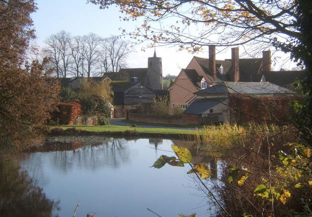
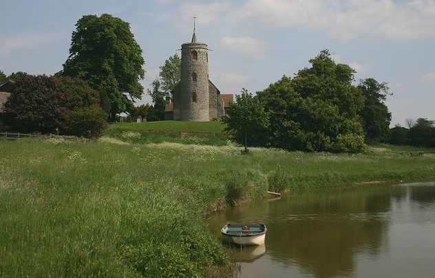
Only 4km (2.5mls) north-east of the centre of Hadleigh, Aldham is thought to be one of Suffolk’s lost medieval villages, which would explain why Aldham Hall (Grade II), originally the manor house, and the adjoining Church of St Mary (Grade I), with its round tower, stand isolated in the south-west of Aldham parish. Nearby, ancient woodland and a medieval deer park are suggested by place names, field boundaries and two parts of a former wood are shown on the tithe map that was surveyed in 1839, although only Park Wood survives today.
Behind a Georgian render, Aldham Hall conceals a rare fifteenth century timber-framed house, with the southern wing preserving an open hall thought to date to c. 1420. In 1609 the manor of Aldham was sold by Thomas Tilney to Sir Edward Coke, Knt. and it stayed in the Coke family until 1764 when the Aldham Hall Estate and lordship were bought by Sir Joshua Vanneck. The Vanneck family sold the manor including the leased Aldham Hall Farm of 230ha (568a) in 1817, becoming the property of Bartlet Bridger Sheddan, Esq., who was said to be the son of a slave owner in Jamaica and documented as resident of the Hall, making him a likely candidate for the later rendering to the outside of the house. It passed to Thomas Barrett Lennard on his marriage to Mary, only daughter and heiress of Bartlet, at which time the farm was once again rented out – the 1851 census lists Thomas Partridge (1800–75) at Aldham Hall and farming c. 215ha (533a). At the turn of the century it was still owned by the family, having passed to Sir Thomas Barrett Lennard, Bart., who is registered as the occupant in 1912, but who also lived at Belhus in Essex. Sold during the twentieth century, Aldham Hall continues to be a farmhouse.
Surveyed in 1839, the tithe map suggests Aldham Hall was once surrounded by a rectangular moat, remnants of which may survive as a pond to the north of the house. The garden area around the house was used for orchards during the nineteenth and into the early-twentieth century, although today these have been replaced with lawns and specimen trees.
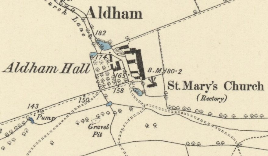
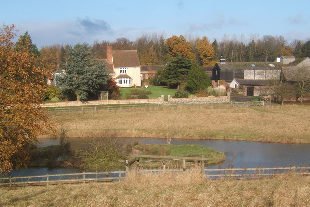
To the south of the site a tributary of the River Brett flows from east to west. By 1884, this stream was dammed to form a pond that has been expanded over the last fifty years to create an attractive ornamental feature with central island in full view of the Hall, the surrounding area of ‘parkland’ now dotted with trees.
SOURCES:
Beresford, M., The Lost Villages of England. London, 1954; Beresford, M. and Hurst, J. G., (eds), Deserted Medieval Villages, 1971. Information from Department of History, University of Hull (https://www.dmv.hull.ac.uk/dmvDetail.cfm?dbkey=4529&county=true, accessed February 2017).
Burke, John, ‘Shedden of Paulerspury Park’ in A genealogical and heraldic history of the Commoners of Great Britain, Vol. 3.
Copinger, W. A., The Manors of Suffolk, Vol. 3, 1909.
Hoppitt, Rosemary, Deer Parks of Suffolk 1086–1602, 2020.
Page, Augustine, Topographical and Genealogical, The County of Suffolk, A Supplement to the Suffolk Traveller (of J. Kirby), compiled 1811 and published in 1844 by Page, Joshua.
Suffolk Institute of Archaeology and History, Excursions 2016, Vol. XL Part 4, 2004.
Census: 1851, 1861, 1891, 1911
1845 (surveyed 1839) tithe map and apportionment.
1884 (surveyed 1884) Ordnance Survey map.
1905 (revised 1902) OS map.
2022 Google aerial map (Imagery © Bluesky, CNES / Airbus, Getmapping plc, Infoterra Lts & Bluesky, Maxar Technologies, Map data © 2022).
Heritage Assets:
Suffolk Historic Environment Record (SHER) ADH 004, ADH 008, ADH 014, ADH 016, ADH 018, ADH 019, ADH 039.
Aldham Hall (Grade II), Historic England No: 1037439.
Church of St Mary (Grade I), Historic England No: 1037438.
Suffolk Record Office (now Suffolk Archives):
SRO (Ipswich) FB4/N/1/77. Lease and release.
Site ownership: Private
Study written: December 2022
Type of Study: Desktop
Written by: Tina Ranft
Amended:
