Parish: BEYTON
District Council: MID SUFFOLK
TL 936 624
Not open to the public
South of Beyton (Bayton or Beighton) village and close to the southern boundary of the parish with Hessett, Beyton House is c. 13km (8mls) east of Bury St Edmunds. The headwaters of the Black Bourn, also known as the Sapiston River, rise in this clayland area and ultimately flow into the Little Ouse River to the north. The main Ipswich to Bury St Edmunds road once passed through the village until the A14 dual carriageway bypassed it in 1978. With a thirteenth century round tower, the parish church of All Saints (Grade II*) is a short distance to the north.
OWNERS OF BEYTON HOUSE
In 1524 a Roger Cooper (or Cowper) is documented as a farmer in the parish, suggesting that he had once owned the site of the house named ‘Coopers’ shown on an estate map of 1729, which had become a tenanted farm owned by James Sturgeon by that date. In 1838 the tithe apportionment lists the estate and house as owned and occupied by William Walpole Esq., although by 1851 he had moved to Beyton Lodge, the smaller surviving unlisted Georgian house to the north that he also owned, from where he farmed c. 100ha (250a). At this time the magistrate and rector of Hessett, Henry B. Blake, was living at Beyton House. Passing down through the Walpole family during the nineteenth century, Beyton House had a succession of tenants, while the Walpoles continued to live at Beyton Lodge. In 1913 the Beyton House Estate was for sale and appears to have been broken up, with later directories of stock breeders suggesting Beyton House became the farmhouse attached to surrounding land. The altered tithe apportionments suggest that a J. Thomas had become the owner by July 1921. In 1965 it was advertised for sale after the death of its owner, Major Robert Edwards, when it was acquired by the family who were running a poultry business from the site in 2013.
BEYTON HOUSE
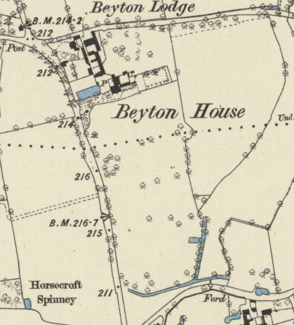
The map of 1729 shows an L-shaped pond, believed to be the remains of a moat that once surrounded a previous house, around the large tenanted farmhouse named ‘Coopers’, which lay beside the road running north to south from Beyton village to Hessett, known as Quaker Lane. The house faced north into an enclosed courtyard with a substantial barn further north and smaller building, possibly stables, to the east. A single-storey house lay beyond on the site of the present Beyton Lodge, which borders today’s Cangles Lane. Surveyed in 1837 and attached to the 1838 tithe apportionment, the tithe map shows a replacement house had been built on the site of ‘Coopers’ which became known as Beyton Hall or Beyton House. It was sited slightly further to the east and the old moated site became a partly-walled kitchen garden. Probably built for William Walpole, this new house faced south and overlooked parkland. A new house called Beyton Lodge had been built to replace the earlier small cottage immediately to the north, which William Walpole later moved to and used as a base for his farming activities.
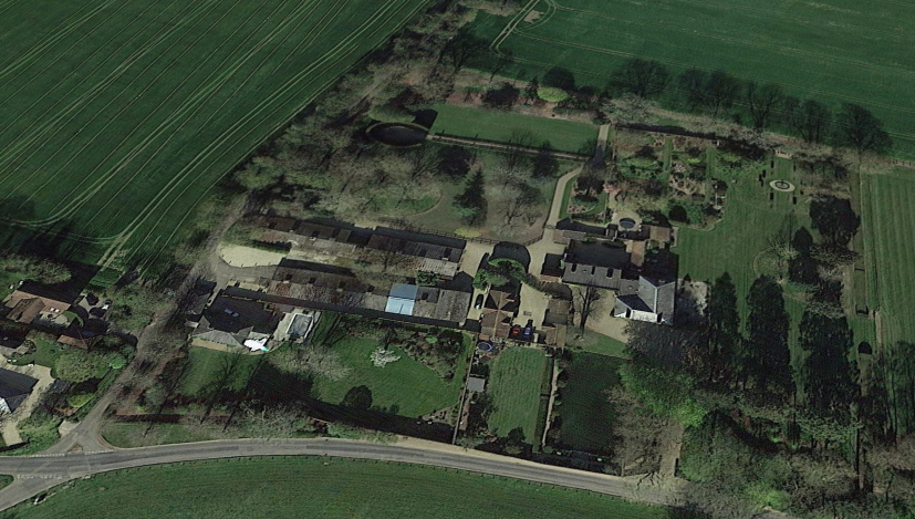
By 1884 Beyton House had been extended with a new wing to the rear (north) and large conservatory backed by a narrow building and courtyard beyond. The house was destroyed by fire and in 1936 the current red brick country house was built on the foundations of the earlier house.
THE PARK AND PLEASURE GARDENS
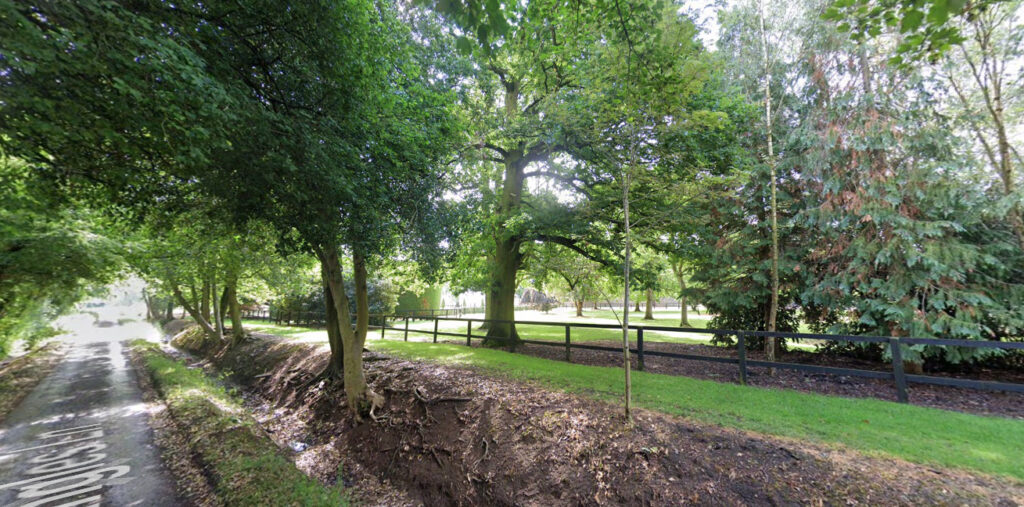
By 1838 there was parkland to the south, east and north of the new house. What appears to be a sinuously curving fence separating the gardens from the southern parkland is depicted on the Beyton tithe map. By this time the parkland extended over the parish boundary with Hessett to give the house far reaching views to the south where the park was dotted with freestanding trees and had a shelterbelt along the southern boundary with trees lining the western boundary along the road between Beyton and Hessett. At the intersection of the parish boundaries and fields there is a circular feature depicted as trees that survives to the present day. It is likely this historically acted as a boundary landmark before the establishment of comprehensive maps. To the east of the house, the northern and southern sections of parkland were separated by a further fence that led to a field named ‘Great Folly’ on the Beyton tithe apportionment and in Hessett ‘The Folly (part)’. The Hessett tithe map indicates a track leading eastward towards a wood beside the stream called ‘Summer House Plantation’. Although not shown on the Beyton tithe map, a continuation of this track towards Beyton House seems likely. Both reference to a folly and summerhouse are suggestive of elements of an earlier, designed landscape possibly from the seventeenth or early-eighteenth century. The northern parkland had a belt of trees giving privacy along the lane running east to west known as Cangles Lane.
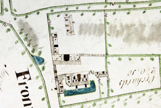
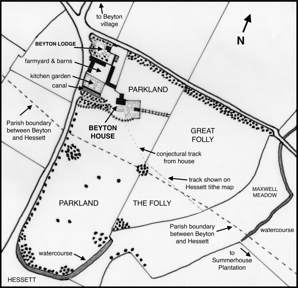
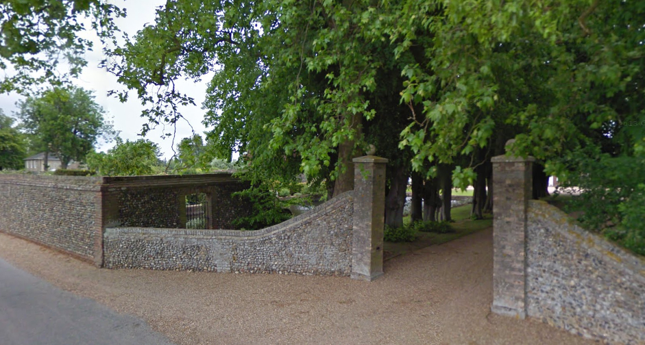
The building of the new house further east allowed the site of the old house to become a kitchen garden. Having lost its eastern arm, by 1838 the remaining arm of the moat had become a rectangular ornamental garden canal bordering the southern side of the partly-walled kitchen garden, probably reusing brick walls from the earlier house. With its entrance off the road between Beyton and Hessett, the drive from the west was lined with trees and ran parallel to the canal. This led to the south front of the house with an oval-shaped drive. A courtyard and stables were to the north. Formal gardens and paths on a geometric plan lay further to the east where flowers and possibly more vegetables were grown. A large building of unknown use, but possibly an ornamental summerhouse or orangery, lay within the formal gardens from where there was access to a fenced track running eastward that divided the north and south parks to a field named ‘Great Folly’ on the Beyton tithe map. The farmyard, barns and other buildings lay north and north-east of the partly-walled kitchen garden, and further north was Beyton Lodge and its gardens with circular drive surrounded by trees and shrubs to the front (west) and kitchen garden to the rear (east).
In 1865 Beyton House was described as ‘a handsome building, standing in a small well wooded park’. By the time of the 1884 OS map, a larger but simpler garden with perimeter path had replaced the earlier formal gardens and the possible summerhouse had gone. Buildings to the north and a large barn north of the kitchen garden had also been replaced. In addition, a belt of trees by the west entrance had been expanded to give more privacy to the house.

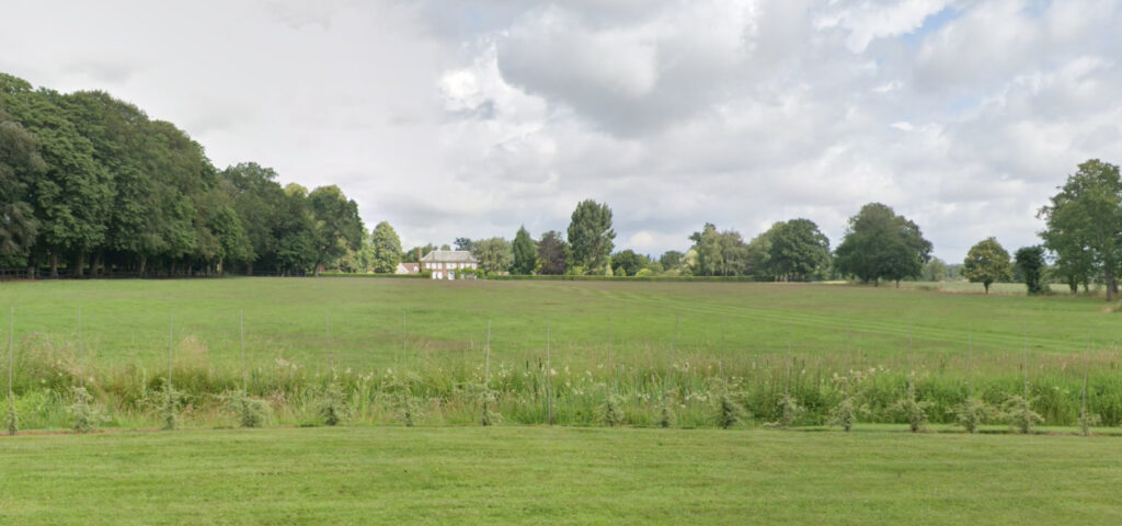
Except for an extension of the garden area to the south front of the house and the addition of a second entrance drive off Cangles Lane to the north, little changed to the park and garden layout between 1884 and the building of the new house in 1936. Following the sale of Beyton House in 1965 the new owners began a project to restore and extend the grounds. This has seen the canal restored to give a dramatic vista when viewed from the west elevation of the house and the partly-walled kitchen garden laid to lawn. Sections of wall along the boundary with the lane to the west have been rebuilt over the years and the area of garden to the south of the house has been extended to give a lawn bordered by a hedge with a small gap and depression, perhaps a ha-ha, separating the garden from the parkland beyond. A mown strip in the park now creates a dramatic southern vista centred on the house. East of the house the gardens have been planted with ornamental trees and a path edged with hedges and avenue of trees leads into the north park with a vista culminating in an ornamental circular coniferous-hedged focal point. Part of the northern parkland is now used as paddock but within it are a number of freestanding trees of various ages.
SOURCES:
Alston, Leigh, Coach House & Stables, Beyton House, Church Road, Beyton, Suffolk, Heritage Asset Assessment, 2013 for Suffolk County Council.
Barker, H. R., West Suffolk Illustrated, 1907.
Country Life, Vol. 138, 1965.
Copinger, W. A., The Manors of Suffolk: The Hundreds of Stamford, Stow and Thedwestry Vol. 6, 1910.
Kelly’s Directory of Suffolk, 1865.
Kelly, E. R., Post Office Directory of Norfolk & Suffolk, 1865, 1879.
International Directory of Pedigree Stock Breeders, 1928.
White, William, History, Gazetteer, and Directory of Suffolk, 1844, 1874.
1783 Hodskinson’s Map of Suffolk in 1783.
1837 (surveyed 1837) tithe map and apportionments.
1884 (surveyed 1883) OS map.
1905 (revised 1903) OS map.
1952 (revised 1950) OS map.
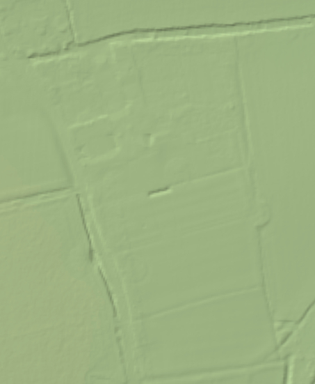
2016 LiDAR image.
2023 Google Earth.
2023 Google aerial map (Imagery © Bluesky, CNES / Airbus, Getmapping plc, Infoterra Lts & Bluesky, Maxar Technologies, Map data © 2023).
Heritage Assets:
Suffolk Historic Environment Record (SHER): BEY 011, BEY 016.
Church of All Saints (Grade II*). Historic England No: 1032500.
Suffolk Archives (previously Suffolk Record Office):
(SA) E3/30/13.19. Hayward, N., Map of estate belonging to James Sturgeons, Hessett/Beighton, 1729.
(SA) HE 503/2/63, Sales Particulars, August 1913.
Historic England Archive: SC00975, Beyton House Estate near Bury St Edmunds, Sale 6 August 1913.
Site ownership: Private
Study written: October 2023
Type of Study: Desktop
Written by: Tina Ranft
Amended:
