(previously called The Wilderness, Wentworth Hall and Blackheath Villa)
Parish: FRISTON
District Council: EAST SUFFOLK (previously Suffolk Coastal)
TM 422 579
Not open to the public
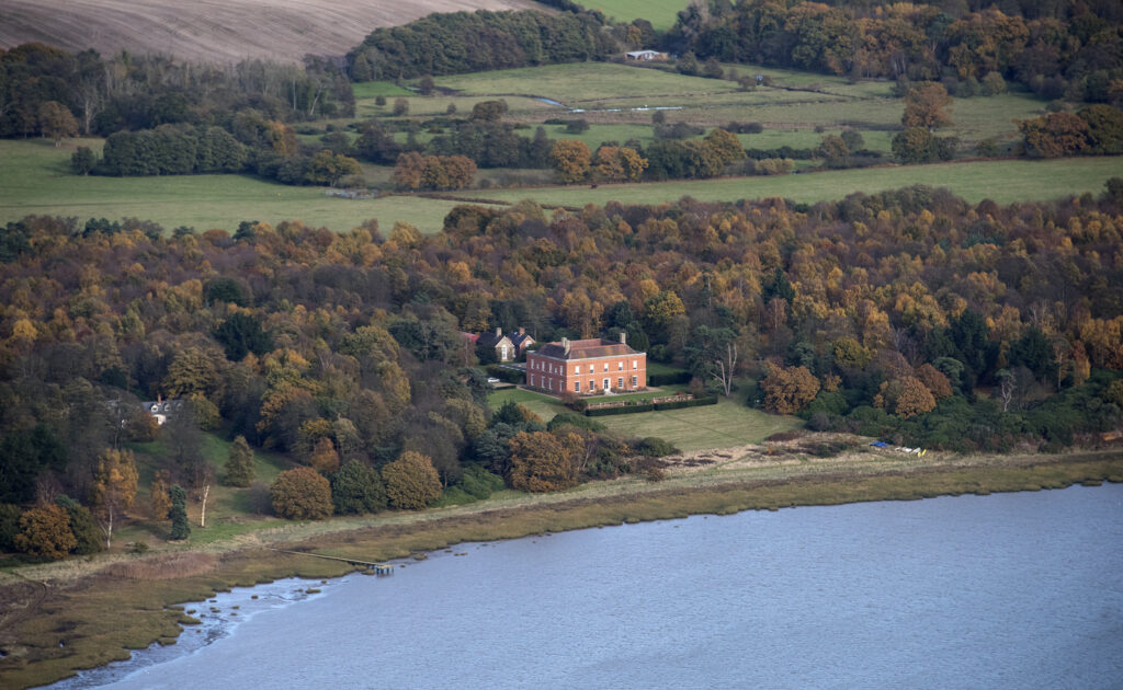
In an isolated position in the south of the parish of Friston, Blackheath House sits on a slight rise, surrounded by saltmarsh, intertidal flats and woodland on the north bank of the River Alde. The North Sea and the town of Aldeburgh are c. 4.8km (3mls) to the east.
Once part of the large Friston Hall Estate, this area of heath, woodland and creeks was sold off in the early-nineteenth century to become the Black Heath Estate. Inherited by Leveson Vernon, who owned property in Aldeburgh and Stoke Park in Northamptonshire, a house, keeper’s cottage and wall around the eastern boundary were built on the site and it is believed he also created the plantation with a series of drives that surround the house. Nestled within the plantation north of the mansion, the keeper’s cottage is shown on the tithe map (surveyed in 1839 to accompany the 1847 tithe apportionment). This ornamental flint cottage with leaded casement windows and decorative bargeboards is listed as mid-nineteenth century, although it could be slightly earlier and contemporary with ‘Black Health Villa’, which is marked on the 1837 OS map, and possibly built soon after the Black Heath Estate was created. During this period the house was sometimes called ‘The Wilderness’.
Leveson Vernon died unmarried in 1831, leaving his Suffolk properties to his ward Susanna Smith Ratledge (c. 1789–1873) who later married Capt. Thomas Bagnold (1780–1848). She lived at the house until her death when it passed to her goddaughter Susan Pettit, daughter-in-law of one of her tenants, when it was let to Col. Arthur John Bethall Thellusson of Thellusson Lodge in Aldeburgh and used as a shooting lodge. In 1879 Thomas Vernon-Wentworth, son of Henry Vernon of Hilton and great-grandson of Thomas Wentworth, Earl of Stafford, who owned the Friston Hall Estate, acquired the estate and renamed the house ‘Wentworth Hall’ and later ‘Blackheath Villa’. The old house was demolished c. 1887 to be replaced by a grand red brick mansion in the elaborate Venetian Renaissance style to be used as a shooting lodge by Thomas.
During World War II the house was requisitioned by the Army and after its return it was re-fronted in plain white brick and stripped back to a simple square plan. The property stayed in the Vernon-Wentworth family until 1995 when it was bought by the architects Michael and Patty Hopkins who, whilst retaining the simple south façade, completely gutted the interior to create a modern layout using their signature glass and steel. Today, Blackheath House has a simple terraced lawn down to the water’s edge and two further properties have been constructed nestled in the plantation to the west of the house.
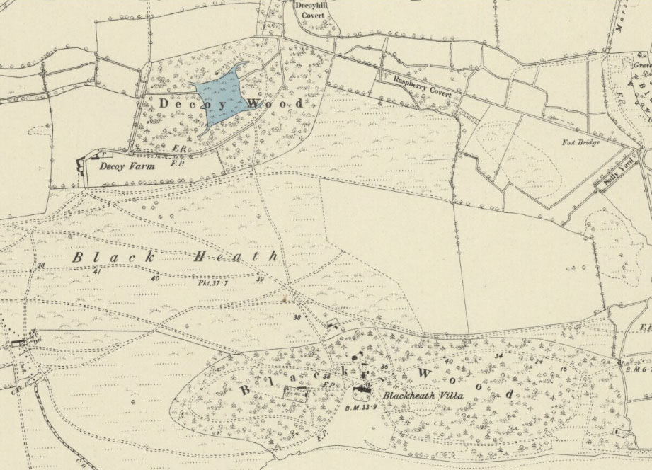
The plantation and series of drives survive much as they were in the early-nineteenth century, although the plantation has expanded by taking in some health land to the north to join the wood surrounding a disused duck decoy, previously known as Friston Decoy. Square-shaped, the decoy was constructed before 1736 when it formed part of the Friston Hall Estate and is seen as a prominent feature on both Kirby’s 1736 and Hodskinson’s 1783 maps. The tithe map shows it as roughly square with a curving decoy pipe at each corner set in the wood. By 1905 it appears to have gone out of use and today most of the decoy has been in-filled to form marsh, with a perimeter ditch marking its original shape. Just north of the decoy is an unusual small decoy lodge, which is shown on the tithe map and probably built at the same time as the first house. Although its roof had collapsed, evidence for a fireplace and windows still remained in 2006.
SOURCES:
Page, Augustine, Topographical and Genealogical, The County of Suffolk, A Supplement to the Suffolk Traveller (of J. Kirby), compiled 1811 and published in 1844 by Page, Joshua.
Payne-Gallwey Sir R, The Book of Duck Decoys, 1886.
Williamson, Tom, Sandlings: The Suffolk Coast and Heaths, 2005.
Suffolk Gardens Trust site visit and conversation with the owner Michael Hopkins, May 2006.
http://friston.onesuffolk.net/home/our-village/history/ (accessed June 2020).
Kirby’s 1736 map of Suffolk
Hodskinson’s Map of Suffolk in 1783.
1847 (surveyed 1839) tithe map and apportionment.
1884 (surveyed 1882) Ordnance Survey map.
1905 (revised 1903) OS map.
1928 (revised 1925) OS map.
1950 (revised 1945) OS map.
2022 Google aerial map (Imagery © Bluesky, CNES / Airbus, Getmapping plc, Infoterra Lts & Bluesky, Maxar Technologies, Map data © 2022).
Heritage Assets:
Suffolk Historic Environment Record (SHER): FRS 004.
Cottage 20 metres north of Blackheath Mansion (Grade II), Historic England No: 1287970.
Suffolk Record Office (now Suffolk Archives):
Suffolk Record Office (Ipswich) HD2833/2/SC242/33/7. Sales Particulars of parts of Black Heath Estate, 2 July 1919.
SRO (Ipswich) HE402/2/1919/21. Sales Particulars of the Black Heath Estate, 2 July 1919.
SRO (Ipswich) HD2833/1/SC003/12. Sales Particulars of the Black Heath Mansion Estate, 1995.
Site ownership: Private
Study written: January 2023
Type of Study: Desktop and 2006 site visit
Written by: Tina Ranft
Amended:
