Parish: CREETING ST MARY
District Council: MID SUFFOLK
TM 103 545
Not open to the public
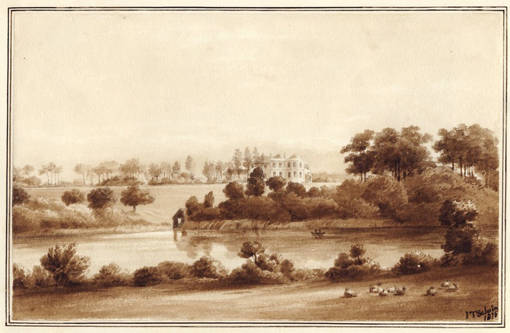
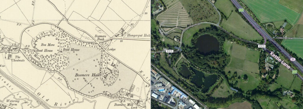
In central Suffolk c. 1.6km (1ml) south-east of Needham Market and c. 10.5km (6.5mls) north-west of Ipswich, Bosmere Hall lies on the north bank of the River Gipping, overlooking the valley and ancient Bosmere, a lake covering c. 12ha (30a). The house was built c. 1768 by Admiral Samuel Uvedale (1729–1808), the son of the Revd Samuel Uvedale rector of Barking and keen naturalist, using the money he made during the Seven Years’ War (1756 to 1763). Samuel resigned from the Navy in 1780 and spent most of his last days at the Hall. His house is shown on Hodskinson’s 1783 map of Suffolk set in its small park beside Bosmere lake. Samuel had sold Bosmere Hall before he died in 1808. During the early part of the nineteenth century John Thomas Ibbetson, later to become Sir John Thomas Selwyn 6th Bart. lived at the Hall and painted many views in the area, including a watercolour dated 1826 of Bosmere Hall overlooking parkland and down to the mere where there is a boathouse on the eastern shore from which to go fishing in the lake.
By 1838 the Hall and its small park were owned and occupied by Sir William Fowle Fowle Middleton, 2nd Bart. (1784–1860), perhaps residing at Bosmere while extensive remodelling took place at his main residence of Shrubland Hall nearby. The tithe apportionment of that year lists grounds comprising a lawn, park, plantations and part of Bosmere lake. The other part was owned by the Earl of Ashburnham, another large landowner in the area. Described by William White in his directory of Suffolk in 1844 as a ‘neat mansion, in pleasant grounds’, Bosmere Hall appears to have been leased out at that time and was home to Major General Chas. Turner, who was probably drawn to it for the fishing, the lake described in 1870 as abounding in fish when it was home to the Wing family.
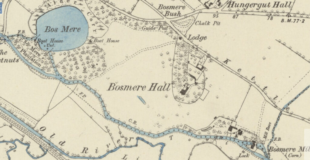
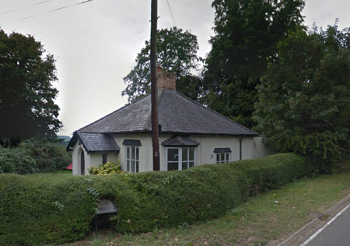
By 1884 the park for Bosmere extended south, east and west of the Hall including the circular ‘Bos Mere’. This had two boathouses with surrounding woodland, including a waterlogged area known as Alder Carr. The boathouse nearest the house was in the same position as one depicted in the Thomas Ibbetson watercolour dated 1826. A shelterbelt of trees formed the northern boundary of the park and gave privacy from Kettle Lane, from where a surviving small single-storey lodge sat at the entrance. On entering the park the drive divided to create an in-and-out drive that passed through woodland and an avenue of deciduous trees. Next to the house were the stables and coach house with an attached enclosure that was probably walled and used as the kitchen garden. A further enclosure lead off this and is shown on the 1884 OS map as having a series of glass frames and corner summerhouse. Another glass structure, probably an orangery, is shown facing south within the compact gardens around the house. This was backed-up by sheds accessed from the stable yard. These elements formed an oval-shaped ‘island’ surrounded by parkland.
Later Bosmere Hall was home to the Tidswell family and Richard H. Tidswell is recorded as leasing the hunting rights over the Shrubland Park estate from Lord de Saumarez in 1896. The family continued to live at Bosmere Hall into the 1920s.
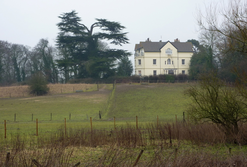
During World War II the site was used to house Italian prisoners. The estate was for sale in 1947 and included the house, gardens, park, paddock, two cottages, stabling, lake and meadows covering 23.5ha (58a) and has been in private ownership ever since. Today some parkland, Bosmere lake with its surrounding woodland and the shelterbelt of trees have survived, much as they were in the nineteenth century. Due to alterations over the years, Bosmere Hall is not listed but still sits in its oval-shaped garden enclosure, although the stables and enclosures to the north of the house have been converted for office and industrial use.
SOURCES:
Birch, Mel, Suffolk’s Ancient Sites Historic Places, 2004.
Kelly’s Directory of Suffolk, 1865.
Kelly’s Directory of Cambridge, Norfolk and Suffolk, 1992.
The Royal Navy 1776–1815. A Biographical and Historical Chronicle, https://morethannelson.com/officer/samuel-uvedale/ (accessed September 2018).
White, William, History, Gazetteer, and Directory of Suffolk, 1844, 1855, 1874.
Wilson, John, Marius, Imperial Gazetteer of England and Wales, 1870–72.
Storey, Richard, A Boy’s Wartime Memories of Suffolk, 2004 at https://www.bbc.co.uk/history/ww2peopleswar/stories/54/a3343754.shtml (accessed September 2018).
Suffolk Artists, https://suffolkartists.co.uk/index.cgi?choice=painter&pid=351 (accessed September 2018).
Hodskinson’s Map of Suffolk in 1783.
1838 (surveyed 1838) tithe map and apportionment.
1884 (surveyed 1883) Ordnance Survey map.
1905 (revised 1902 to 1903) OS map.
1927 (revised 1925) OS map.
Google aerial image (Imagery © Bluesky, CNES / Airbus, Getmapping plc, Infoterra Lts & Bluesky, Maxar Technologies, Map data © 2023).
Suffolk Record Office (now Suffolk Archives):
SRO (Ipswich), HA1/H/B/1/1/2, Lease from Hon. George Ashburnham Viscount St Asaph to William Farquier Esq. of Barking including hunting, shooting and fishing over manors of … Bosmere, 15 February 1795.
SRO (Ipswich), HD4061, Shooting and Hunting Records of Richard Tidswell of Bosmere Hall, 1896-98.
SRO (Ipswich), HE402/1/1947/24, Sales particulars, 18 June 1947.
Site ownership: Private
Study written: October 2023
Type of Study: Desktop
Written by: Tina Ranft
Amended:
