(demolished c. 1760)
Parish: BRIGHTWELL
District Council: EAST SUFFOLK (previously Suffolk Coastal)
TM 251433
Not open to the public
Situated c. 8.8km (5.5mls) east of Ipswich, Brightwell village lies in the wooded valley of Mill River that flows eastward through a gently-rolling plateaux of free-draining sandy soils to join the River Deben. The medieval Church of St John the Baptist (Grade II*) and nearby manor site of Brightwell Hall are on gently-rising ground on the north side of the valley with views down to the river.
Thomas Essington bought the manors of Brightwell, Foxhall and Kesgrave from Sir Richard Wingfield in the early 1650s. Within ten years he sold them to Sir Samuel Barnardiston (1620–1707), son of Sir Nathaniel Barnardiston of Kedington, a prominent Puritan. Sir Samuel, leader of the Suffolk Whigs and a deputy Governor of the East India Company, rebuilt the original manor house in 1663 to create the grand H-shaped Brightwell mansion.
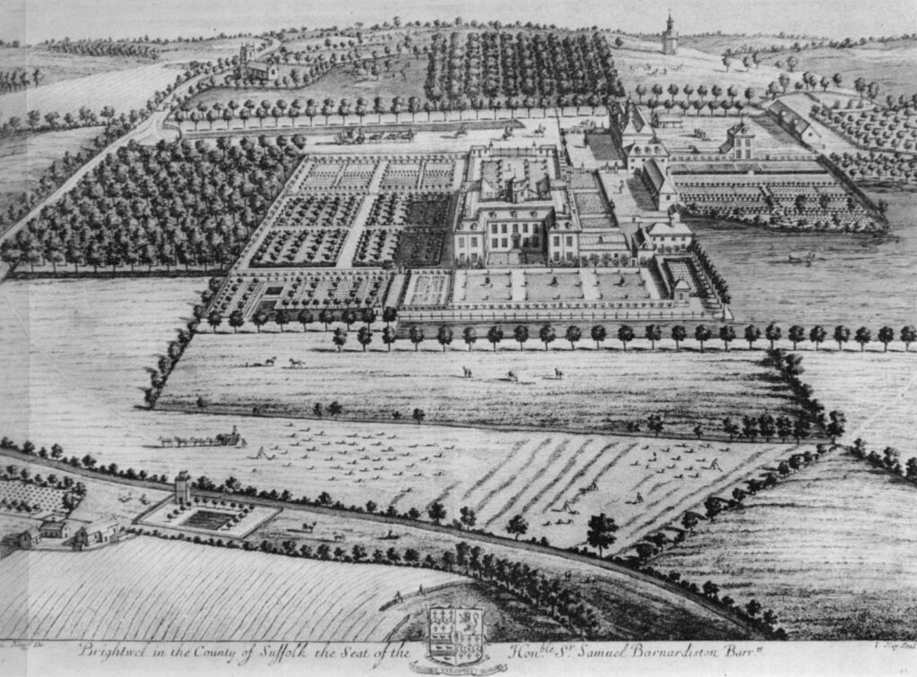
An engraving in the Britannia Illustrata of 1707 by Kip and Knyff shows the mansion surrounded by extensive gardens typical of the Restoration period. To the north of the house is a walled entrance courtyard with wide gates and to the east a partly-walled kitchen garden and farm buildings. Other enclosures contain parterres, lawns and orchards. Water features include a large pond below the kitchen garden linked to an ornamental canal parallel to the house. This is flanked by a terraced walkway and overlooked by a banqueting house. To the west is a smaller L-shaped canal with summerhouse at the corner. A grand avenue leads from the road below the church to give access to the site, continuing eastwards out into the fields and more orchards. There are further lines of trees between the gardens and fields that edge the river below. In the river there appears to be a square island with a tower in one corner surrounding a square pond flanked by trees. Obviously, an ornamental feature because it is in full view of the mansion, it may have had a practical use related to storing fish. A large plantation gives the mansion privacy from the roadway.
How much of Kip and Knyff’s engraving is an idealised depiction is unknown, but it seems likely that it had extensive formal gardens that were destroyed at the same time as the house. Kirby’s 1736 map of Suffolk marks the mansion within a square enclosure, presumably representing the extensive formal gardens.
Brightwell Hall was demolished c. 1760, leaving part of the farm buildings on the site to become a farmhouse. Hodskinson’s later map of 1783 reflects the earlier demolition of the mansion by recording a small house on the site, although still named ‘Brightwell Hall’. A work by John Constable in the Tate Gallery dated 1815 shows the church, farmhouse and pastureland with low linear terracing to the west of the house site, possibly the earthwork remains of the earlier gardens.
During the nineteenth century ownership of the estate changed hands several times and the farm was tenanted. Later nineteenth century maps show that the lake and any sign of the canals had also disappeared.
In 1945 the estate including Hall Farm and its farming stock and equipment were for sale.
Today the house site has been completely redeveloped into a large residential property with newly-planted formal gardens and lake created where one is shown on the Kip and Knyff engraving. Linear earthworks remain west of the house that are likely to relate to garden avenues and walkways attached to the seventeenth century house.
SOURCES:
Britannia Illustrata, 1707.
Copinger, W. A., The Manors of Suffolk, Vol. 3, 1909.
Martin, Edward, ‘Garden Canals in Suffolk’ in East Anglia’s History: Studies in Honour of Norman Scarfe, 2002.
Suffolk Institute of Archaeology and History, Proceedings Vol. IV Part 4, 1870.
Suffolk Institute of Archaeology and History, Proceedings Vol. XXXIX Part 4, 2000.
The Aggregate Landscape of Suffolk: The Archaeological Resource, Interim report for Aerial Survey component Areas One & Two: The Felixstowe Peninsula, English Heritage Project Ref: 3987, PDF version 2011.
Williamson, Tom, Suffolk’s Gardens & Parks, 2000.
http://www.suffolklandscape.org.uk/landscapes/Estate-sandlands.aspx (accessed November 2019).
https://www.tate.org.uk/art/artworks/constable-brightwell-church-and-village-t03121 (accessed November 2019).
Census: 1841, 1851, 1861, 1871, 1881, 1911.
Maps:
1736 Kirby’s Map of Suffolk.
1783 Hodskinson’s Map of Suffolk in 1783.
1885 (surveyed 1881) Ordnance Survey map.
1905 (revised 1902) OS map.
Heritage Assets:
Suffolk Historic Environment Record (SHER): BGL 028.
Church of St John the Baptist (Grade II*). Historic England No: 1030456.
Suffolk Archives (previously Suffolk Records Office):
(SA) HD 11/475/Brightwell/278. Estate of Sir J. G. Shaw – Brightwell Hall, 2 December 1806.
(SA) HD 2833/1/SC072/2 and 5. Brightwell Estate Sales Particulars, 27 October 1942.
(SA) FC 48/N2/1. Particulars of sale of Brightwell Estate, 1942.
Site ownership: Private
Study written: November 2025.
Type of Study: Desktop and external visit 2008.
Written by: Tina Ranft
Amended:
