(demolished 1949)
Parish: CAVENHAM
District Council: WEST SUFFOLK (formerly Forest Heath)
TL 761 692
Not open to the public
The late-nineteenth century Cavenham Hall once stood in its own small park, c. 30m above sea level, 12km (7.5 ml) north-west of Bury St Edmunds, but was demolished in 1949. The site is in the village of Cavenham, by a tributary flowing northward to join the River Lark, which flows westward through Mildenhall to Littleport in Cambridgeshire. The house and park were on the edge of an area of flat river terraces with sandy free-draining soils that have historically had limited land-use. This gave rise to extensive areas of heathland. The once sheep-grazed Cavenham Heath in the north of the parish was an airfield in World War II. It was later lost to quarrying for sand and gravel and majority of it is Cavenham Heath National Nature Reserve, a Site of Special Scientific Interest (SSSI) managed by Natural England.
The area has been settled from an early date, with Bronze Age building remains found in the parish. The ancient trackway of Icknield Way borders the southern edge of the old boundary of Cavenham Park.
OWNERS OF CAVENHAM HALL
The ancient manor of Cavenham Hall had a succession of owners including Thomas Bedingfield in the late-sixteenth century followed by Richard Long and Robert Johnson. In 1767 it was bought by the wealthy merchant and director of the South Sea Company, Thomas le Blanc. Esq., who is shown as the owner on Hodskinson’s 1784 map. A painting by John Hamilton Mortimer (1740–79) in the Norfolk Museum shows his second son Simon and Simon’s nephews in an idealised scene depicting a shooting party at Cavenham Park.
The estate was sold to the first Marquess Cornwallis in 1794. The Marquess lived at nearby Culford Hall, and was bought by Henry Spencer Waddington in 1809. In 1864 it passed to Henry’s son, also called Henry Spencer Waddington, MP for Bury St Edmunds. It stayed in the family for nearly a century until 1898 when it was sold to Herbert Ernest Matthew Davies. Herbert demolished the original mansion and began to build a new house on a site further south and more central within its park. Sadly, Herbert died before the work was completed and his widow sold the Cavenham Estate to Adolph Goldschmidt, father of Sir James Goldsmith the financier, who had the work completed.
Once more for sale in 1918, it was eventually bought as a home by Brigadier General Sir Archibald Home, largely for its excellent shooting opportunities.
After World War II the 1,063ha (2,627a) Cavenham Hall Estate was sold to farmer Douglas Gough of Lackford, who came to live at the hall. However, Douglas only stayed for a short period until he and his family moved to Lackford Manor, another house and estate they owned. Wishing to farm much of the wider estate, the family failed to sell the house and pleasure gardens alone as a country residence. Eventually they demolished the house in 1949, but kept hold of Cavenham Park and Estate. Family members now live at Little Hall, a new, smaller property that replaced the demolished house in the park and continue to farm the Lackford and Cavenham Estates.
CAVENHAM HALL
A house called Cavenham Hall existed when Cavenham Park was created after the Cavenham Enclosure Act of 1772. The enclosure map of 1802 shows a U-shaped house close to the village and the early-thirteenth century Church of St Andrew (Grade II*). It faced east towards the village but was separated from the village street by outbuildings.
For sale and advertised in the local press in 1808, the estate was said to be 850ha (2,100a) and included ‘offices of every description, courtyard, extensive gardens, pleasure gardens, plantations comprising 100 acres [40.5ha] with 3 open field farms and a valuable sheep walk’. A year later it was sold to Henry S. Waddington. The Waddingham family’s home was described by William White in 1874 as ‘a handsome mansion in a park’ and the 1884 OS map clearly shows the house and outbuildings towards the park’s northern edge and close to the village street.
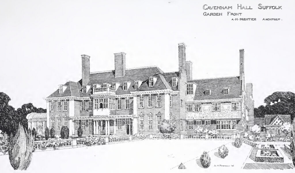
Having demolished the old hall, a new house was built in 1898/99 for Herbert Ernest Matthew Davies to designs by Andrew Noble Prentice, who was known for his Arts and Crafts buildings, although the house has been described as of a ‘late Renaissance style’ Built on higher ground to the south-west of the old house, it was almost central within its park. Possibly from the 1930s, an undated photograph at Suffolk Archives of the same elevation as Prentice’s drawing shows that most of his design for the house was implemented.
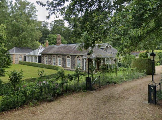
At the same time the old stable block and coach house near to the site of the original house and close to the surviving walled kitchen garden were replaced. The new stable block and coach house (Grade II) were described in 1901 as ‘charmingly situated between the present house and the garden’ with ‘only the gate piers retained from the previous buildings’. The hall was finally demolished in 1949 when it was said to be ‘unwanted for any purpose and falling into disrepair’. The stable block and coach house survive and have been converted into residential properties.
CAVENHAM PARK AND GARDEN
The Cavenham Estate was renowned for its shooting, even before the original landscape park was created by Thomas le Blanc in 1773, which was soon after the Enclosure Act allowed open fields and common land of the parish to be enclosed and privately owned. The wording of the Act only mentions an existing mansion with dovehouse and avenues but no park. Some ten years later Hodskinson’s map shows an indistinct small park with shelterbelt of trees along the western boundary.
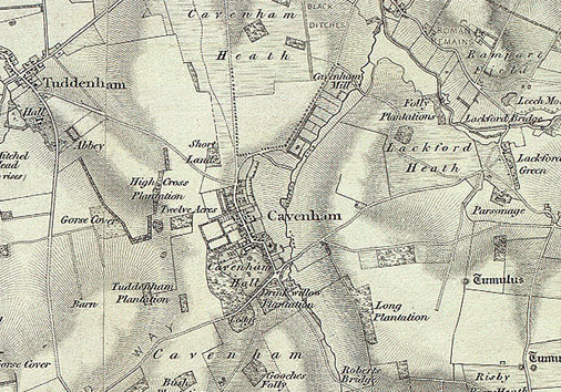
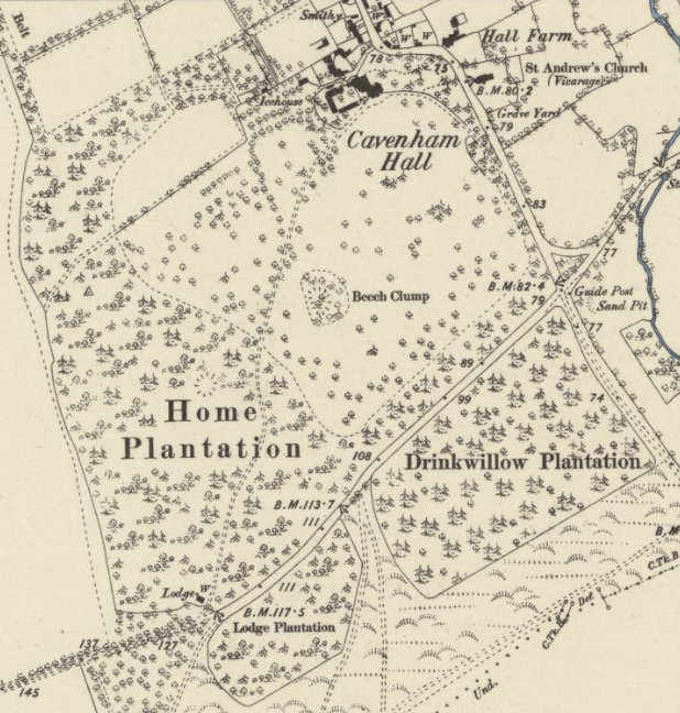
By the time of the first edition OS map of 1836 the design of the park becomes clearer. It had a winding main drive, with an entrance lodge from the south-west, off the Icknield Way. This passed through a plantation of coniferous and deciduous trees before entering the parkland that was dotted with freestanding trees. The drive passed a wooded feature called ‘Beech Clump’ to arrive to the south of the eighteenth century house. From here there was access to the stable block before the drive turned south-westward along the edge of parkland and beside a belt of trees to a further entrance off the village street close to the parish church. The map also shows a number of garden enclosures to the north of the house.
Showing the old mansion on the north edge of the park, the 1884 OS map gives more detail. In addition to the main drive, a further track led westward from the walled garden through ‘Home Plantation’ to open fields beyond. A rear entrance from the street led directly to the stable block with a large walled garden to the north. This had a further garden enclosure attached to its west side, although it is unclear if this was walled. A small building within this area is named ‘Icehouse’ and to the south there was an orchard. Although parkland was confined to the north side of the Icknield Way, Lodge and Drinkwillow Plantations extended the woodland across the road. They were separated by a strip of rough ground and paths leading out into heathland beyond.
With the building of the new mansion more centrally in the park, Adolph Goldschmidt further landscaped the park to designs by the engineer and landscape architect Henry Ernest Milner. Henry was the son of Edward Milner who had connections to Joseph Paxton, the famous landscape designer noted for his hothouses such as the Crystal Palace for the Great Exhibition of 1851.
Henry is believed to have designed a fern dell and rock garden within the pleasure grounds c. 1901. Having previously worked on a number of projects with the Pulhams of Broxbourne in Hertfordshire who were known for their artificial rock gardens, ferneries, terracing, balustrading, vases and garden ornaments, it has been suggested in a report published by English Heritage (now renamed Historic England) that the Pulhams may have been involved in their construction at Cavenham. However, there is no known documentary evidence.
The work may also have included the proposed balustrading shown in Andrew Noble Prentice’s 1899 drawing for the house, although an undated photograph at Suffolk Archives, possibly from the 1930s, of the same elevation as Prentice’s drawing does not show the balustrading flanking paths. It is unclear if it was lost in the interim or not originally built. However, the formal layout featuring an ornamental terrace of lawns, flowerbeds, gravel paths and pedestals in the photograph show a remarkable similarity to those in Prentice’s drawing, suggesting at least part of Henry Milner’s hard landscaping was implemented.
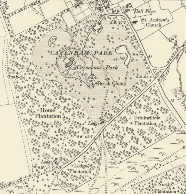
A new drive with entrance lodge designed by Andrew Prentice had been created off the Ickneid Way directly south of the house and close to the paths leading into the heathland to the south. Within the park the drive curved east of Beech Clump and the house that lay within an irregularly-shaped garden enclosure. This drive crossed another drive towards the new stable block and coach house and onward to a north-west-facing entrance front of Prentice’s house. Part of the old main drive from the south-west survived but was cut short at the edge of the parkland. By 1905 an irregularly-shaped ornamental lake had been created in the east of the park.
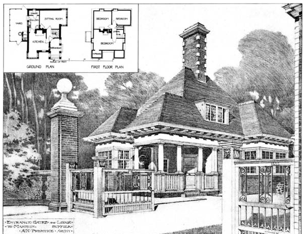
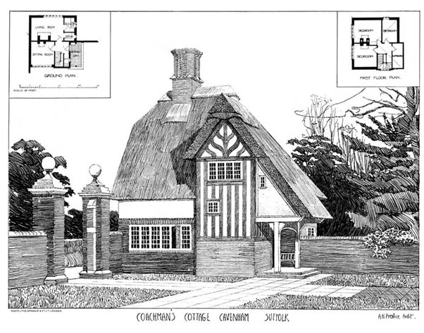
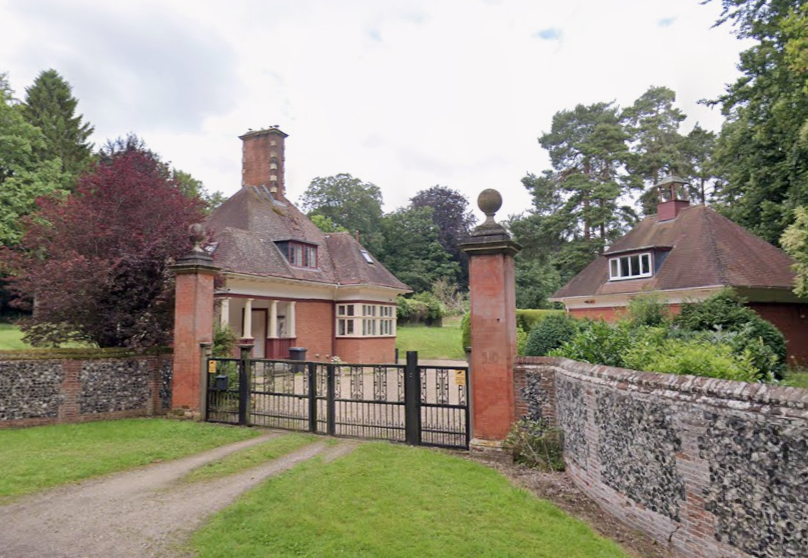
A sinuously-shaped garden enclosure had been added around the house that was probably bounded by a ha-ha. It enclosed a square entrance forecourt immediately to the north-west of the house for cars and carriages. To the south a formal area of garden, not unlike that shown in Andrew Prentice’s drawing, gave way to a square, fashionable rose garden with yew hedging. Beyond were lawns with level areas for tennis and croquet and paths winding their way to Beech Clump. This may have been the site of the rock garden and fernery. By this time Cavenham had c. 2.8ha (7a) of walled gardens for flowers, fruit and a kitchen garden. The whole was described in 1913 as ‘one of the most beautiful gardens in Suffolk’. Andrew Prentice also designed a new gated south entrance and lodge, a replacement south-west lodge and added a coachman’s house with thatched roof beside the coach house.
During the ownership of Brigadier General Sir Archibald Home and after World War I, the estate is said to have been well-managed with ‘extensive walled gardens and fernery as examples of the care and attention lavished on the property’. For sale after World War II, the 1946 sales particulars describe an estate of 1,063ha (2,627a), which was to be sold in lots. Cavenham Hall, the park, pleasure grounds, lake and stable/garage block, chauffeur’s cottage and lodges comprised 41.5ha (103a). Another lot was called ‘The Estate Gardens’ , which was described as a market garden holding of 2.4ha (6a), with a house, buildings and walled garden. In the event Douglas Gough bought the whole estate.
By the beginning of the twenty-first century the extent of the parkland remained much as it was a century before, although the pleasure gardens associated with the demolished hall have mostly been swept away. The entrance lodges had been sold, their associated drives became redundant and are now separate residential properties. The south-west lodge, known as ‘Porters Lodge’, marks the entrance to the grounds of a new house surrounded by trees within Home Plantation. The southern lodge also survives with grounds extending to the edge of the parkland. Part of Home Plantation had been lost to arable cultivation, although most of the nineteenth century plantations have survived as shelterbelts. Sections of brick and flint park boundary walls of unknown date remain beside the village street. A stone column of unknown date and providence with ionic detailing can be seen in a grass depression beside the wall.
The main access to the new house known as New Hall is the original entrance in the village. It is shared with the stables and coach house courtyard that are now also separate residential properties. Modern stabling has been erected next to the remains of the original walled garden, now used as a paddock, and it has been suggested that remains of the icehouse survive in this area.
SOURCES:
Birch, Mel, Suffolk’s Ancient Sites Historic Places, 2004.
Burke, Bernard, A Genealogical and Heraldic History of the Landed Gentry of Great Britain & Ireland, 1914.
East Anglian Daily Times, 26 August 1949.
English Heritage (now Historic England), Durability Guaranteed: Pulhamite Rockwork – Its Conservation and Repair, 2008.
Country Life, Vol. 76, 1934.
Garden Life, Vol. 24.
Gentleman’s Magazine, 1864.
Hay, Douglas C. ‘Le Blanc, Sir Simon (1748/9–1816)’ in Oxford Dictionary of National Biography. Hitching, Claude, Rock Landscapes. The Pulham Legacy, 2012.
Home, Sir Archibald and Briscoe, Diana, The Diary of a World War I Cavalry Officer, 1985.
Kelly’s Directory of Suffolk, 1853.
Perciful, ‘Arts and Crafts Influences’ in The Gardener’s Chronicle, August 1885 and October 1896.
Roberts, W. M., Lost Country Houses of Suffolk, 2010.
The Architectural Review, Vol. 6 June to December 1899. https://archive.org/details/architecturalrev06unse/page/n327/mode/2up (accessed December 2020)
White, William, History, Gazetteer and Directory of Suffolk, 1844, 1874.
Williamson, Tom, Suffolk’s Gardens and Parks, 2000.
https://suffolklandscape.org.uk/landscapes/rolling-estate-sandlands/ (accessed December 2020).
https://cavenham-parish.co.uk/cavenham-heath/ (accessed November 2025)
http://santondownham.org/Archive/22villagesfull/cavenham22/the_hall.htm (accessed December 2020).
Painting by John Hamilton Mortimer entitled ‘A Shooting Party at Cavenham Park, Bury St Edmunds, Sir Simon le Blanc and nephews’ undated, believed to be between 1767 and 1779. Norfolk Museums Service. Reference from www.stedmundsburychronicle.co.uk/Chronicle/1700-1812 (accessed December 2020).
Maps:
1736 Kirby’s Map of Suffolk.
1783 Hodskinson’s Map of Suffolk in 1783.
1802 Cavenham Enclosure Map.
1836 Ordnance Survey map of Suffolk.
1884 (surveyed 1882) OS map.
1905 (revised 1903) OS map.
1952 (revised 1950) OS map.
Heritage Assets:
Suffolk Historic Environment Record (SHER): CAM 003.
Church of St Andrew (Grade II*). Historic England No: 1192820.
stable block and coach house (Grade II) English Heritage No. 1037609.
Suffolk Archives (formerly Suffolk Record Office):
(SA) E3/18/5. Inclosure Acts and Awards of Cavenham, 1772–1802.
(SA) K 997. Walton Burrell Archive of photographic images, c. 1875–1930.
(SA) HD 1325/63. Cavenham Park Estate, Sales particulars and printed euphemera, September 1913.
(SA) HG 500/1/630/13. Survey of Cavenham Hall, 1919–57.
(SA) HD 1325/63. Photograph of garden front of Cavenham Hall, nd [c. 1930s).
(SA) HD 2833/1/SC093/1. Sales particulars of Cavenham Park Estate, 20 June 1946.
(SA) HD 1325/75. Contents of Cavenham Hall, Cavenham. Sales particulars, 1 September–31 October 1946.
(SA) K 564/184–187. Photographs of Cavenham Hall, exterior views, 1949.
Historic England Archive:
SC 00980. The Cavenham Park Estate Sales Particulars, 26 September 1918.
Site ownership: Private
Study written: December 2025
Type of Study: Desktop
Written by: Tina Ranft
Amended:
