Parish: SHIMPLING
District: BABERGH
TL 853 527
Not open to the public
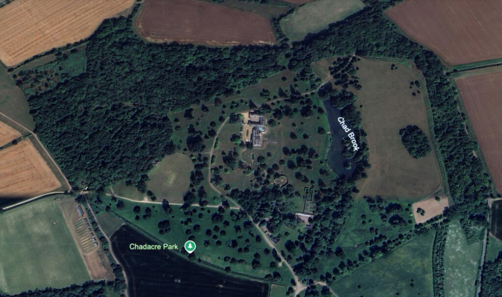
Standing isolated on high ground overlooking the Chad Brook as it flows south to join the River Stour at Long Melford, Chadacre Hall (Grade II) lies in a landscape park c. 13km (8ml) south of Bury St Edmunds within the parish of Shimpling. Chadacre was once a sub-manor of Shimpling – known as Shimplingthorpe during the nineteenth century – with its own manor house that was on another site near the present house. The parish consists of scattered hamlets and isolated farmhouses with Chadacre situated on its western boundary with Hartest parish, part of the landscape park is in that parish. The surrounding area is gently undulating farmland with chalky clay soil.
OWNERS OF CHADACRE HALL
Chadacre is marked on Faden’s 1736 map of Suffolk as the seat of the Plampin family. A survey taken in 1774 lists the estate’s owner as John Plampin Esq., although at the time the house was known as ‘Paddocks’. The park shown on Hodskinson’s 1783 map roughly corresponds to the present parkland, although the survey taken nine years earlier shows a much smaller area of parkland. The last of the family to live there was Vice-Admiral Robert Plampin whose eventful naval career included the command of St Helena during Napoleon’s incarceration. He died in Florence in 1834 at the age of seventy-two and the Chadacre Estate was sold to London banker Thomas Hallifax (1774–1850), who already owned property in the area and was responsible for building the present mansion.
The Hallifax family became substantial parish benefactors, building houses, the school and schoolhouse and renovating the church. The 1871 census shows a Miss Ellen Hallifax living at the house with eleven servants. In 1878, After Ellen’s death in 1878, her will shows she had a sizeable fortune of £300,000. With no Hallifax male heirs, the estate passed into the Weller-Poley family of nearby Boxted through the marriage of Diana (born c. 1817), the daughter of Thomas Hallifax who built Chadacre Hall, to John George Weller-Poley Esq. (born c. 1812).
Over the following years Chadacre Hall appears to have been rented out and recorded by H. R. Barker in his West Suffolk Illustrated of 1907 as owned by J. G. Weller-Poley.
In 1918 Edward Cecil Guinness, Lord Iveagh of Elveden, purchased the Chadacre Estate of c. 930ha (2,300a), including twenty-two farms and fifty-five houses. Three years later he founded the Chadacre Agricultural Institute on the c. 202ha (500a) mansion and parkland site. This provided free practical training for people working in agriculture from Suffolk and neighbouring counties. It subsequently became well-known and respected, but by the 1980s it was unviable and closed in 1988.
The Chadacre Estate was sold in 1990 to David Hart, a banking and property magnate, with the proceeds going towards setting up the Chadacre Agricultural Trust, which funds projects associated with farming and ecology and is still active today. Enjoying a lavish lifestyle, David was a well-known activist in politics.
Due to ill health, twenty years later David put the Chadacre Estate on the market and it was bought for a sum well over the asking price by Steven Lamprell, an oil and shipping magnate, who remains the owner today.
THE HALL
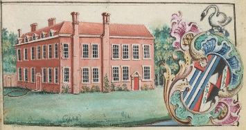
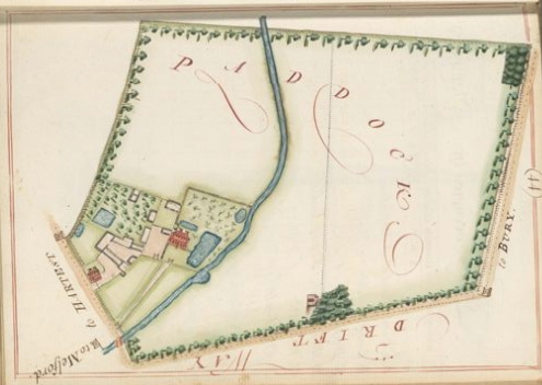
The 1774 survey of John Plampin’s estate gives an image of the mansion, then known as ‘Paddocks’, on a site south of the present house on lower ground close to the Chad Brook and in the area of today’s walled gardens complex. The large house depicted is a red brick Elizabethan-style building with two storeys plus attics.
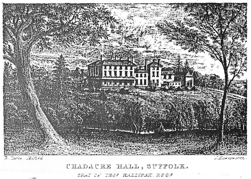
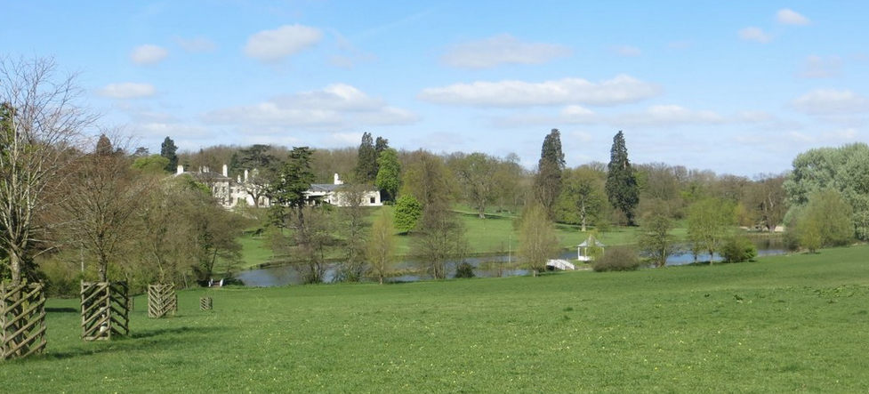
Replacing the earlier house, the present stuccoed Regency house was designed by Philip Hardwick, the architect known mainly for his public buildings including St Batholomew’s Hospital (1826), for Thomas Hallifax. Rainwater heads to the south front are dated 1834, suggesting Thomas commenced the building of his new house immediately after he bought the estate from the Plampin family. It seems likely the mansion was renamed Chadacre Hall at this time. William White’s 1844 directory described the new Chadacre Hall as a ‘handsome mansion in a sylvan park’.
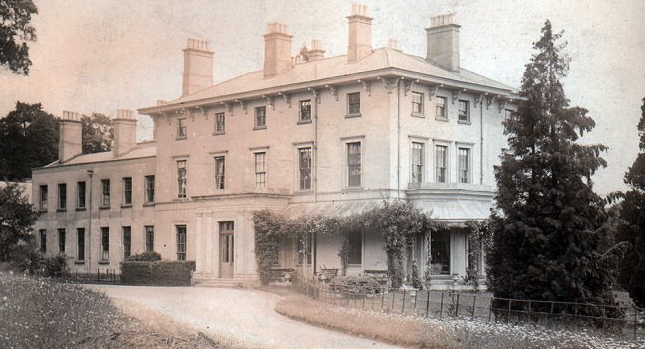
After Chadacre became the agricultural institution in the early-twentieth century additions were made including a concrete wing to the north end and a 1960s chapel. These were demolished by David Hart as part of his extensive restoration of the house to its former Regency glory. After its sale to Steven Lamprell in 2010, further additions were made to the house such as a courtyard building and link extension between the house and stables.
THE PARKLAND
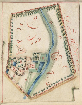
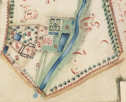
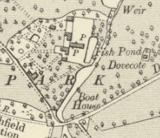
The 1776 survey of John Plampin’s estate includes a number of plans. One is a retrospective plan of the parkland and house site in 1756 and another as it was at the time of the survey. Both show the house on the site was called ‘Paddocks’ and lay south of the present house, close to the brook. If the retrospective plan is correct, by 1776 the parkland had expanded to take in the whole of ‘Dove House Close’ to the east, whilst the western boundary appears to be approximately the line of today’s south drive. The later plan shows the position of the dovecote to the north of the ‘Drift’, today’s Dovehouse Hill, which survived into the twentieth century but is now gone. The buildings and yards to the west of the mansion may have been the original farm buildings associated with the house.
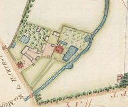
By the time of the tithe map of 1839, Thomas Hallifax’s new house had been built and was surrounded by parkland that had expanded to take in land to the west of today’s south drive. The site of the original ‘Paddocks’ mansion had become a courtyard complex of service buildings and a series of walled enclosures close to the Chad Brook as it flows through the park. The service buildings may represent the home farm associated with the original manor house.
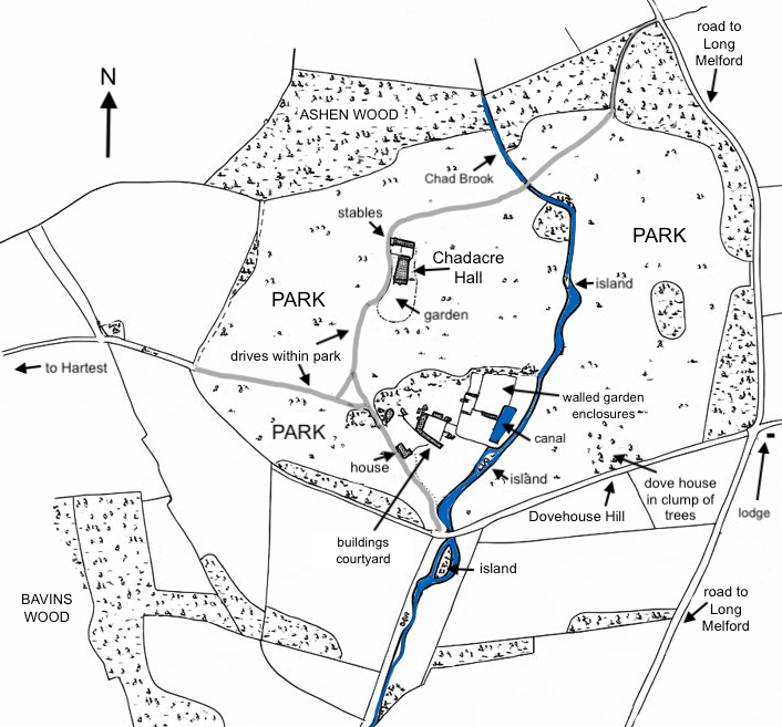
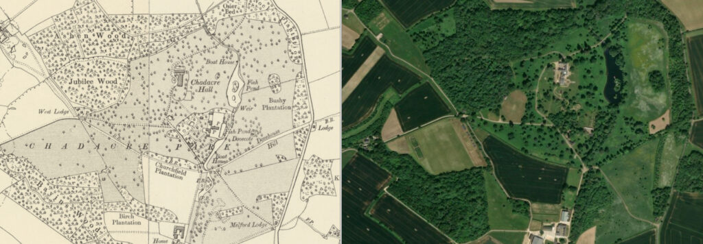
The tithe map shows shelterbelts of trees around the northern and eastern boundaries of the newly-created landscape park. This included Ashen Wood to the north, a surviving semi-natural woodland. To the south-west is Bavins Wood, the remains of ancient woodland that at this time was beyond the parkland boundary. Today both Ashen Wood and Bavins Wood are part of a Site of Special Scientific Interest (SSSI). The parkland is shown to have individual trees dotted throughout with a few clumps to the east of the house.
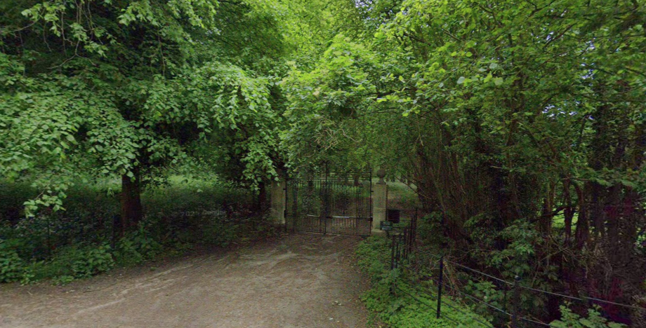
As today, in 1839 there were three entrances with drives. The main one curved from the north-east crossed the Chad Brook, skirted the stable block to arrive at the west front of the house. Not shown on the tithe map, by 1884 it had a lodge named ‘Bury Lodge’, although it was lost sometime in the twentieth century even though the drive continues to be useable. Fairly recently new gate pillars and metal gates have been built. From the west front of the house the drive continues southward to meet the west drive from Hartest and the south drive that joined Dovehouse Hill at a bridging point of the brook. Today Dovehouse Hill is a public bridleway that continues westward towards Hartest, passing ‘West Lodge’ and another called ‘Tower Lodge’. The lodge shown on the tithe map at the top of Dovehouse Hill was lost in the twentieth century, although both ‘Tower Lodge’ and ‘West Lodge’ survive but it is unknown if they are now in separate ownership.
The park was extended southward by 1884 taking in land south of Dovehouse Hill, allowing the southern drive to be extended and ‘Melford Lodge’ built at the entrance off the Melford Road. By this time the Hallifax family had added further trees in the surrounding parkland and widened the Chad Brook to create a serpentine lake with two boathouses and islands.
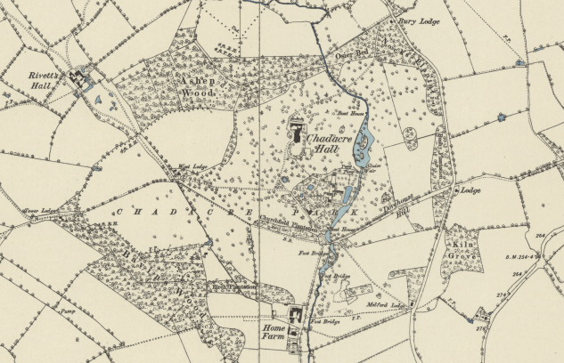
In 1907 the landscape park was described as being c. 38.5ha (95a). This allowed the creation of a new ‘model’ farm as the home farm for the estate, including a U-shaped courtyard of working buildings and a farmhouse on land further south and lying to the west of the brook. Only the plan and shell of the buildings survive today.
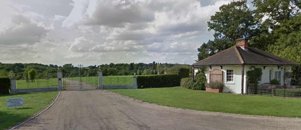
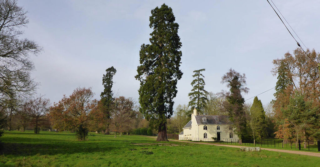
A house beside the south drive is named the ‘Principal’s House’ (Grade II) on Historic England’s listing, which refers to its use by the principal of the Chadacre Agricultural Institute. It features as an un-named building on the mid-eighteenth century survey map, but is dated by Historic England to the late-eighteenth or early-nineteenth centuries, suggesting a complete rebuild or substantial renovation and extension of an earlier building. Its position close to the old mansion site suggests it may have been the farmhouse for the estate’s farm.
PLEASURE GARDENS AND WALLED GARDENS COMPLEX
If the retrospective 1756 survey map is correct, the house at Chadacre was called ‘Paddocks’ with a southern entrance drive leading into a walled courtyard that includes an ornamental canal-like feature to the east of the house. It had one end slightly narrower than the other and was probably an earlier fishpond, a term used on later OS maps. Immediately behind the house there was a smaller canal and beyond a square walled formal garden with perimeter and cross paths. In the centre was an oval pond with box-edged flower beds between the paths. A smaller pond is shown east of this enclosure, beside the brook and north of the large pond. There was a bowling green and orchard west of the house, the bowling green with two small buildings in the corners that were likely to be summerhouses. The orchard with a square pond was north of a courtyard of buildings, probably service and farm buildings.
By 1774 the square, formal garden had gone so that the whole enclosed area around the house was now lawn.
Once the new Chadacre Hall was built on higher ground north of the old mansion site, the old house was demolished and the gardens needed to be re-configured. The new house was set in an oval enclosure of pleasure gardens, initially edged with trees that hid from view the old courtyard buildings and walled enclosures below. From the house a path was created down the southern slope towards the old mansion site. During the nineteenth century the service and farm buildings courtyard were demolished and the orchard had been enlarged and developed into an area of grass, shrubs and trees with a number of criss-crossing paths.
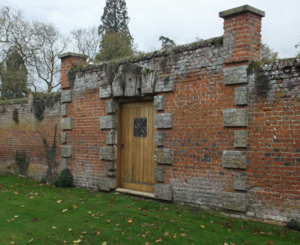
Surviving walls of the enclosures around the old mansion were re-purposed to create two main walled gardens, one surrounding an orchard, plus two smaller gardens. During the nineteenth century these enclosures were altered and extended at various times, as were glasshouses against the walls. They were further developed as the propagation and kitchen gardens of the agricultural institute. Throughout this period the large canal-like feature and small square pond in the orchard survived.
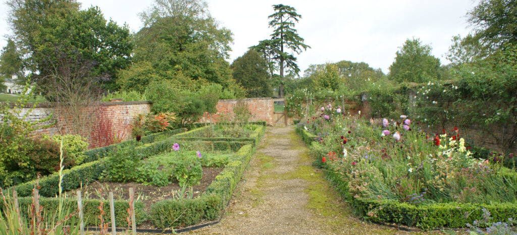
At the time of the sale of the estate in 2010 the gardens consisted a herb garden created on one of the terraces down the southern slope, croquet lawn and swimming pool, walled gardens and the lake with its islands. The sales particulars of that year also refer to 38ha (94a) of woods, 168ha (415a) of organic farmland and seven estate houses.
Since buying Chadacre Estate in 2010, the present owners have made further alterations to the gardens with additional terracing of the sloping area south of the house. The lake has been extended and major restoration work has been undertaken to the remaining two rectangular walled gardens with an additional yard enclosure with large south-facing glasshouse built. Land has been cleared and a number of trees have been removed from the area around the walled enclosures allowing them to be seen from the windows of the house.
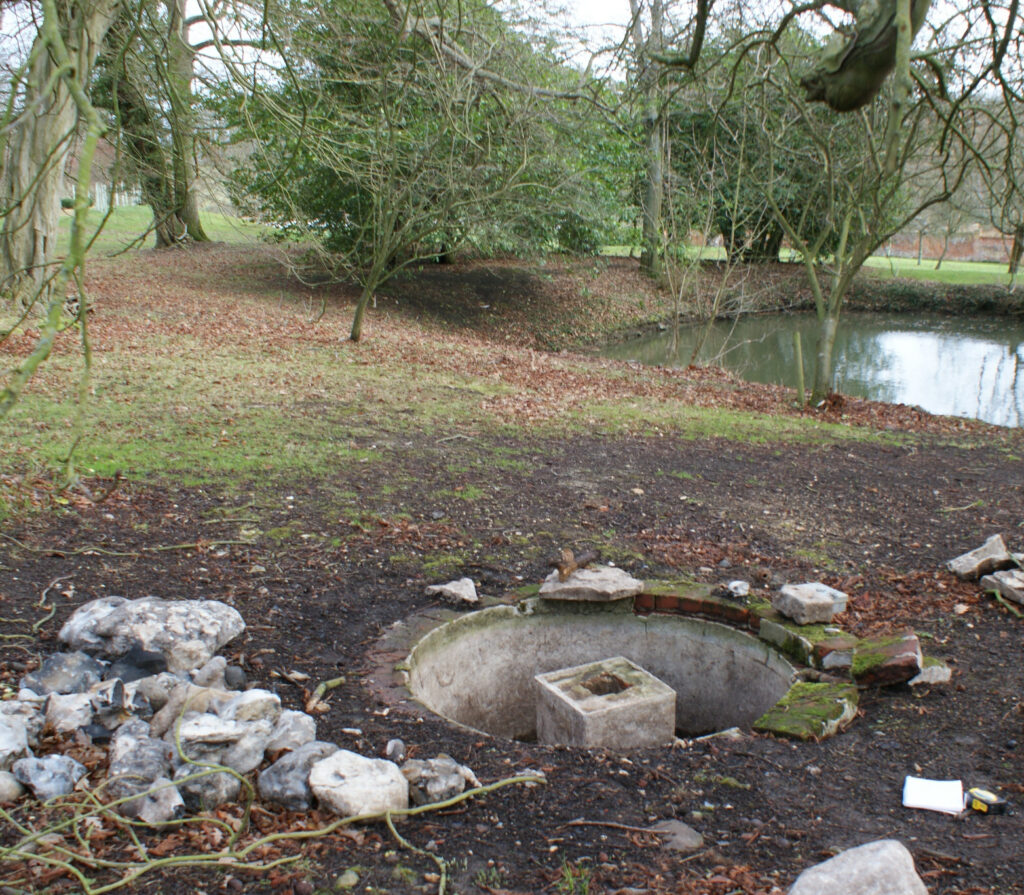
These works revealed the base of a freestanding-glasshouse, possibly for exotics, and the remains of a fountain that were once beside the paths from the house to the enclosures, probably dating from the mid- to late-nineteenth century. The pond originally in the orchard survives although the other canal-like ponds have been filled in. The largest has left the ghost of its edges in changes to the colour of grass in this area.
SOURCES:
Barker, H. R., West Suffolk Illustrated, 1907.
Birch, Mel, Suffolk’s Ancient Sites Historic Places, 2004.
Burke, J. B., A Visitation of the Seats and Arms of Noblemen and Gentlemen of Great Britain and Ireland, 1854.
Copinger, Walter, Arthur, The Manors of Suffolk: Notes on Their History and Devolution, Vol. 3, 1909.
Country Life article, April 2010.
Cox’s County Who’s Who Series, Suffolk, 1912.
Fiske, Jane (ed.) The Oakes Diaries. Business, Politics and the Family in Bury St Edmunds, 1778–1800.
Illustrated London News Weekly Report of Wills and Bequests, 1878.
Suffolk Gardens Trust Walled Kitchen Gardens Recording Group, Peter Cunard, Survey of ‘Chadacre Hall’, Shimpling, 2017 (unpublished document)
Welch, Charles, Dictionary of National Biography, 1885–1900, Vol. 24, Hallifax, Thomas.
White, William, History, Gazetteer, and Directory of Suffolk, 1844, 1874.
https://www.foxearth.org.uk/1858-1861BuryFreePress.html (accessed March 2021)
https://shimpling-pc.gov.uk/organisations-and-clubs/hallifax-trust/ (accessed October 2025)
Chadacre Agricultural Trust, www.chadacre-trust.org.uk/history.html (accessed March 2021).
David Hart obituary, 11 January 2011, https://www.independent.co.uk/news/obituaries/david-hart-flamboyant-banking-heir-who-made-his-name-as-thatcher-rsquo-s-political-fixer-during-the-1980s-miners-rsquo-strike-2181068.html (accessed February 2026).
https://www.eadt.co.uk/news/renowned-estate-sells-for-16m-1990232 (accessed December 2026)
Census: 1871, 1881, 1891, 1901
Maps:
1736 Faden’s Map of Suffolk
1783 Hodskinson’s Map of Suffolk in 1783.
1839 (surveyed 1839) tithe map and apportionment.
1884 (surveyed 1884) Ordnance Survey map.
1905 (revised 1902) OS map.
1927 (revised 1924) OS map.
2026 Google Earth.
Heritage Assets:
Suffolk Historic Environment Record (SHER): SPL 004, SPL 009, SPL 029.
Chadacre Agricultural Institute (Grade II). Historic England No: 1351906. (NB: the official listing was done in 1978 when the site was the Institute but is no longer)
Principal’s House Chadacre Agricultural Institute (Grade II). Historic England No: 1033555. (NB: the official listing was done in 1978 when the site was the Institute but is no longer)
Suffolk Archives (previously Suffolk Record Office):
(SA) 86125. Hallifax family of Chadacre Hall deeds and estate papers, 1551–1907.
(SA) HA 519. Weller Poley & Hallifax families in Suffolk, deeds and papers, Seventeenth to Twentieth Centuries.
(SA) 1511/210/3. Plan of Chadacre Estate by J. G. Lenny, surveyor, 1823.
(SA) SC00981. The Chadacre Hall Estate sales particulars, 4 December 1918.
(SA) HD 526/121/4©. Report of Lord Iveagh’s gift of Chadacre Hall as a Farm Institute for the counties of East and West Suffolk, December 1919.
(SA) 1180. Chadacre Estate sales particulars, 1989.
(SA) EG 573/4/1/3. Proposed extension to Chadacre Hall, October 2010–January 2011.
Site ownership: Private
Study written: February 2026
Type of Study: Desktop and site visit 2017
Written by: Tina Ranft
Amended:
