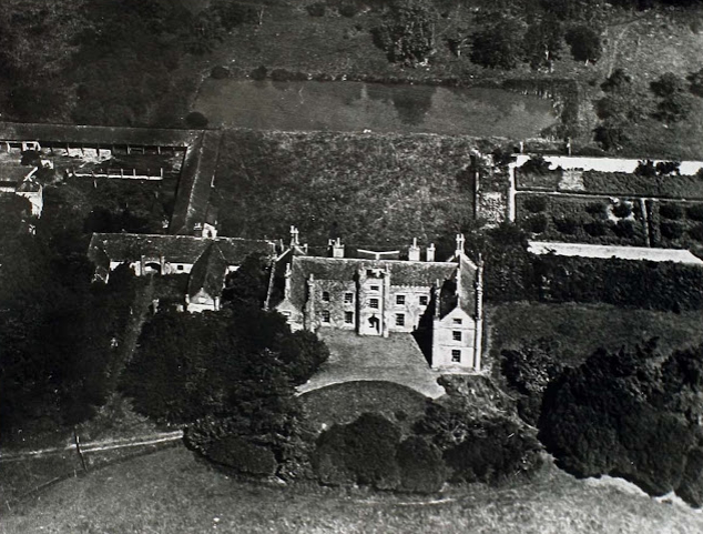
(Hall demolished in 1955 and replaced with new farmhouse)
Parish: CHEDISTON
District Council: EAST SUFFOLK (previously Suffolk Coastal)
TM 371 777
Not open to the public
(With the permission of Nicholas Kingsley at https://landedfamilies.blogspot.com/search?q=Chediston+Hall)
Lying on the edge of the Suffolk clay plateau, the present twentieth century Chediston Hall farmhouse is remote from Chediston village, close to the eastern parish boundary and c. 1.6km (1ml) west of Halesworth. It stands isolated on higher ground to the north of a stream that flows via The Beck river to join the River Blyth.
A house is known to have occupied the site since at least the sixteenth century. The Pettus family owned the estate during the seventeenth century, later passing to the Fleetwoods. With Tudor origins, in 1735 the house was said to have been rebuilt in ‘a beautiful Manner’ by Walter Plumer who ‘made it his seat’, although a lease dated 1801 shows that Chediston Hall was a tenanted farm. G. W. Parkyns purchased the estate in 1833 and largely rebuilt the house in a neo-Jacobean style. On his death, and after some legal technicalities regarding his right to own property, it eventually passed to his sister M. C. Leguen de Lacroix but appears to have been tenanted as a farmhouse over the following years, although Eugene Jean Leguen de Lacroix lived there at his death in 1936. Requisitioned during World War II, it suffered fire damage and remained unoccupied until its demolition in 1955, after which the farming estate was sold to James Aldous (1933–2010) who built a new farmhouse on the site, which continues to be owned by the family in 2025.
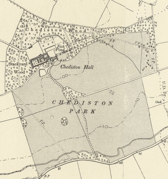
In the middle of the nineteenth century Chediston Estate covered over 809ha (2,000a), with a landscape park to the south of the house that was probably created when the Hall was rebuilt in the 1830s for G. W. Parkyns, although it may have been created earlier by Walter Plumer in the eighteenth century. The 1839 tithe apportionment records the park as covering c. 47ha (115a) and the accompanying map, surveyed in 1838, shows surrounding parkland with three drives: from the east and towards the Wissett road; from the south-west and zig-zagging to follow field boundaries and the main drive to the south with entrance flanked by woodland where it joined the road from Chediston village to Halesworth. The latter had a small wood flanking the drive at its midway point in the otherwise mostly open parkland. A large pond lay south-west of the house beside the entrance drive and Stackyard Wood and Chediston Wood surrounded the house to the north, east and west. These had winding paths through them and were extensions to the pleasure gardens. The gardens in the vicinity of the Hall were set within an enclosure marked by a ha-ha and included a rectangular ornamental canal running parallel to the north elevation of the house. This is possibly an eighteenth century ornamental feature and it is not known if it was newly-constructed or perhaps created from the remains of a moat associated with a much earlier house and formalised at the time of the first rebuilding of the Hall. A group of farm buildings, stables and coach house were north-west of the house and immediately to the east was an area that was probably a lawn flanked by ornamental planting. A perimeter path lead into Chediston Wood with another path alongside the southern wall of a walled kitchen garden to a building, possibly an orangery, that gave access into the kitchen garden.
Whites 1844 directory notes that all the mature timber in the park had recently been cut down and new plantations created. There was little change to the landscape park and gardens over the following two hundred year, except by 1883 the east drive had become a footpath. Its route in front of the house became the surviving ha-ha with adjacent shrubbery immediately south of the entrance forecourt giving some privacy but at a loss of views across the parkland from the house.
More major changes took place after the demolition of the old house and building of a new farmhouse. Gradually the parkland and Stackyard Wood have been turned to arable, although Chediston Wood survives mainly intact. The footpath in front of the house has gone, although a public footpath skirts Chediston Wood to the north, as does another south of the house. The other two drives survive, the main southern one now with an avenue of trees at its northern end. A large collection of modern farm buildings has replaced the earlier farmyard, stables and coach house and additional residential properties lie to the north and east of the house. The canal has been infilled to be replaced by grass that extends to the surviving northern ha-ha and some surviving walls of the kitchen garden feature in today’s ornamental gardens.
SOURCES:
Bellamy, Denis and Downing, Ruth, Halesworth. An Ecological Society, 2006. http://www.culturalecology.info/halesworth/halesworth_html/index.htm#_Toc152117887 (accessed January 2023)
Cromwell, Thomas. K., Excursions in the county of Suffolk, 1818.
Kirby, J., The Suffolk Traveller, 1735.
Martin, Edward, ‘Garden Canals in Suffolk’ in East Anglia’s History: Studies in Honour of Norman Scarfe, 2002.
Roberts, William, Lost Country Houses of Suffolk, 2010.
Suckling, A., A History & Antiquities of Suffolk, Vol. II, 1848.
White, William, History, Gazetteer and Directory of Suffolk, 1844.
Landed families of Britain and Ireland blog, ‘Aldous family of Freston House and Chediston Hall’ https://landedfamilies.blogspot.com/search?q=Aldous (accessed September 2022)
1839 (surveyed 1838) tithe map and apportionment.
1883 (surveyed 1882 and 1883) Ordnance Survey map.
1905 (revised 1903) OS map.
1928 (revised 1926) OS map.
1951 (revised 1947 to 1948) OS map.
2022 Google aerial map (Imagery © Bluesky, CNES / Airbus, Getmapping plc, Infoterra Lts & Bluesky, Maxar Technologies, Map data © 2022).
Suffolk Record Office (now Suffolk Archives):
SRO (Lowestoft) 1019/3/2. 25th September 1801. Lease from William Plumer of Gilston Park, Gilston, Herts, Esq to John Beales the younger of Chediston, farmer.
SRO (Ipswich) HB26: 10975/6). Chediston Estate Map, 1845.
Heritage Assets:
Suffolk Historic Environment Record (SHER): CHD 057, CHD 058, CHD 059.
Church of All Saints (Grade I), Historic England No: 1036718.
Site ownership: Private
Study written: January 2025
Type of Study: Desktop
Written by: Tina Ranft
Amended:
