Parish: CLAYDON
District Council: MID SUFFOLK
TM 137 498
Not open to the public
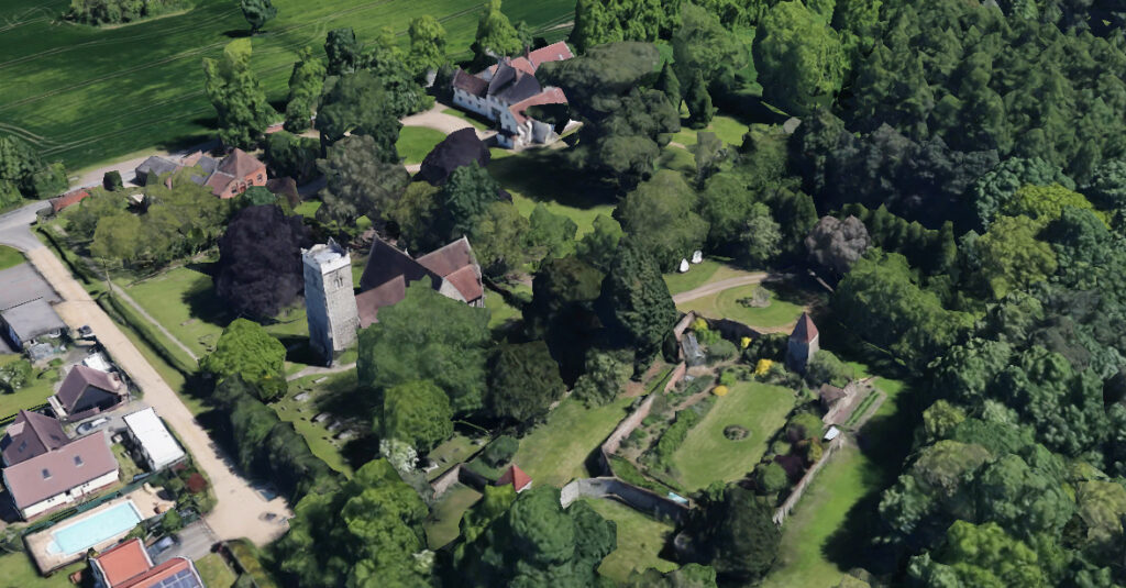
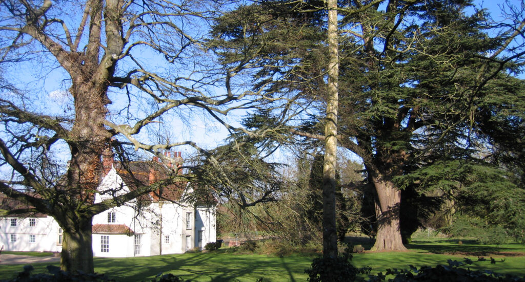
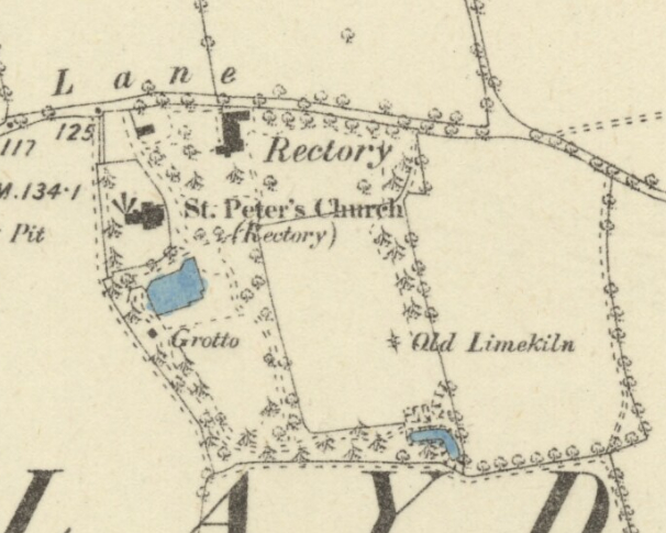
The former rectory at Claydon stands at c. 40 metres above sea level on the edge of the valley of the River Gipping. With mid-sixteenth century origins the The Old Rectory (Grade II) had major alterations over several periods. It stands next to the Church of St Peter (Grade I) dating back to the Saxon period, which was substantially altered in the mid-nineteenth century. The church was made redundant in 1977 and is now in the care of the Churches Conservation Trust. The site of the old rectory and its gardens are bounded by Church Lane to the north, a path leading from the lane southward to join other paths around arable fields that lie south and east of the gardens.
The Poll Book of 1832 records the Revd Richard Etough as the resident of the rectory and he was recorded as still there some five years later on the tithe apportionment. However, by 1851 it was the Revd George Drury (1819–95), one of the High Church eccentrics, who had become the resident clergyman and was living at the rectory with his wife and young family. It is not known if there was a family relationship to the Revd Drury named beside a drawing of the rectory on Hodskinson’s 1783 map of Suffolk. It seems likely this Drury had a family relationship with the once prominent and influential Drury family of Hawstead, Roughham and Rushrooke.
The Revd George stayed for most of the second half of the nineteenth century and founded a convent of Benedictine nuns in parish in 1866 that survived until 1882. He was noted for his Anglo-Catholic sentiments, antagonising many local protestants and turning popular opinion against him. The situation was so bad that he is said to have built the surviving c. 2.75m (9ft) brick and flint wall along the road boundary of the rectory after he suffered physical violence from some parishioners to himself and his property.
The situation was no better in the neighbouring parish of Akenham where George was also the incumbent. Tensions arose when George would not recognise the churchwarden, a noted nonconformist, who had been elected by the parishioners. This culminated in the widely-publicised Akenham Burial Case of 1878, which is said to have been a plot by local protestants against George. It involved the refusal to bury a young child because the coffin arrived accompanied by a Congregational minister from Ipswich who attempted to hold a burial service for the child. The Revd George, as uncompromising as ever, refused to allow the child to be buried in the churchyard. The case ultimately led to a change in national burial laws.
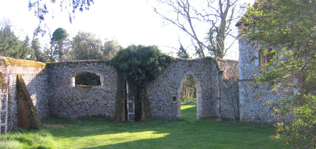
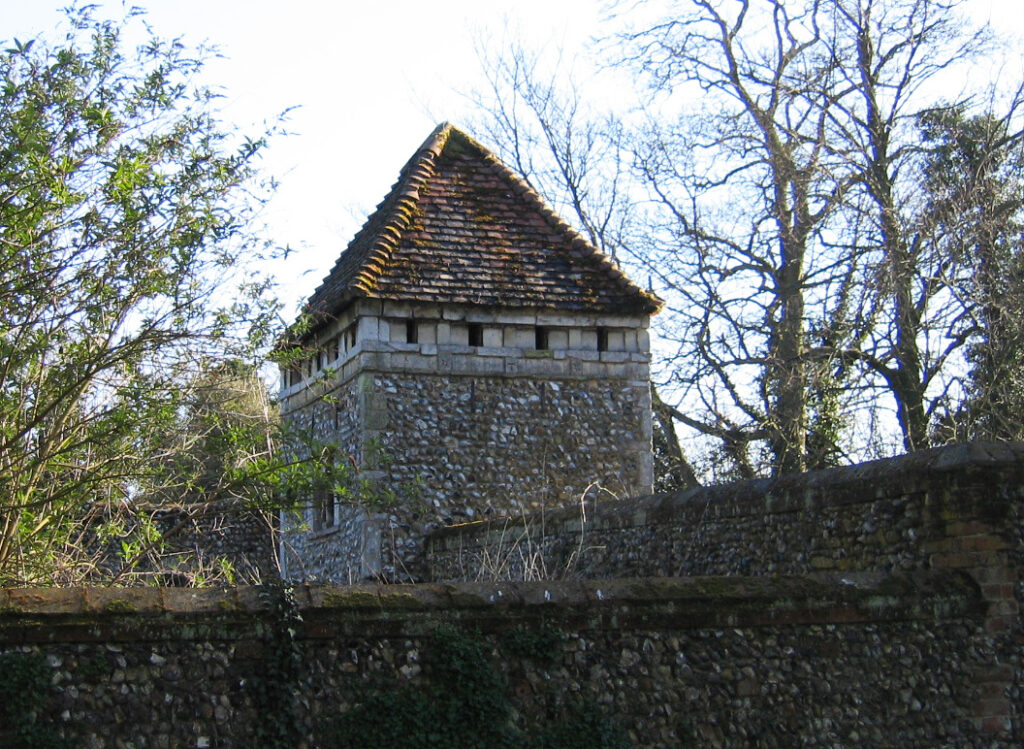
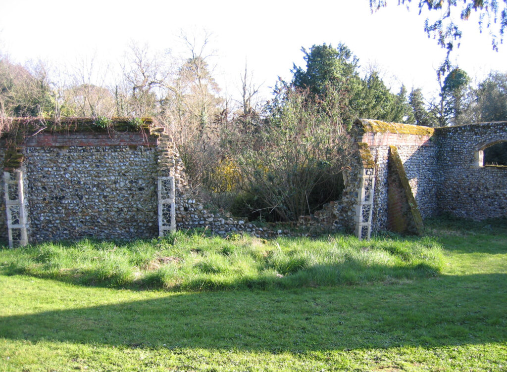
Fairly early on in his incumbency George built himself a surviving eccentric walled garden with towers (Grade II) just south of the church, reputedly a Biblical allegory. Built of flint and brick with stone dressings, it has decorative gateways with a spur wall on the north-west corner and two towers to north-west and south-east. Some of the material in the walls is said to have come from the transepts and small chancel of Claydon church that the Revd George demolished in 1852 to replace them on a larger scale. South-west of the walled garden there was an underground grotto lined with shells that is included in the listing for the walled garden, although it is unknown if it still exists. This may have been the work of the Revd George, although Nikolaus Pevsner believed it to be pre-1850, which could make it the work of the Revd Etough, or even the Revd Drury shown on the 1783 map.
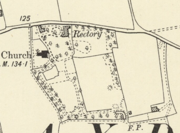
How much of the wider rectory gardens were developed by George is unknown. At the time of the 1837 tithe map and during the incumbency of the Revd Etough, a small area was set aside for the rectory gardens and churchyard, with a gatehouse along Church Lane to the west of the rectory and a short ‘tongue’ of land south of the church bordering the path to the fields. This ‘tongue’ included the site of the grotto, although the tithe map does not show it. Fields beyond to the south and east were classed as glebe land and likely to have been grazed parkland.
Over the next forty-five years the gardens expanded by taking in the grazed parkland south of the church, creating L-shaped pleasure gardens. There was a lawn to the south of the house and the newly-incorporated field became a lawn surrounded by a path through belts of coniferous and deciduous trees to the south and west with a gap in the area of the grotto, presumably so it could be viewed from the path. The eastern boundary of the new lawn was open to the field to the east except for a few deciduous trees dotted along its length. This field appears to have become parkland including an ‘Old Limekiln’ marked on the 1884 OS map, one of a number of ancient kilns that used the local chalk deposits to produce lime mortar and plaster. It could be viewed from the lawn to the south-east of the house. An L-shaped pond in the south-east corner of the parkland was surrounded by trees and its eastern boundary had a belt of trees except for a small gap that was flanked by two circular mounds, presumably to frame to view and give vantage points from which to view the fields beyond. A line of deciduous trees bounded the road to the north-east of the house.
Just south of the church the surviving irregularly-shaped walled garden and towers is shown on the 1884 OS map in blue, denoting a pond. Whilst it is possible the walls were built to surround a pond, it seems more likely that this was a typographic error.
After the death of the Revd Drury in 1895 a few clergyman continued in the role of rector and there was little change to the pleasure gardens and parkland until the house was no longer needed as a rectory and sold. In 1955 the then owner, Major John A. Haskell put the property on the market in lots, when it was described as a residential and farming estate with lot 1 the old rectory and grounds of c. 4.45ha (11a). The rest of the land totalled c. 24.7ha (61a).
In 1960, it became the home of Sir Lawrence Grafftey-Smith (1892–1989), a British diplomat, and his wife. By this time it was described as having neglected gardens and ‘a large pond and water garden’, which is likely to be the L-shaped pond in the south-east corner of the old parkland. Since then the house has become commercial offices, with the gatehouse a self-contained rental unit. Gradually the parkland to the south has become overgrown to become a wood. It was eventually sold-off leaving c. 2.35ha (5.8a) of grounds, including small areas of the overgrown woodland, the walled garden and lawns dotted with nineteenth century trees with biblical references such as the Tree of Heaven (Ailanthus altimissa), Judas Tree (Cercis siliquastrum) and Christ’s Thorn (Paliurus spina-Christi) around the house.
The old rectory became the office headquarters for Screen Electronics before the 1990s, but was for sale during that period by the receivers of the company. In 2025 it was once more for sale as commercial office space with planning permission for a separate new annex and additional car parking. The sales particulars suggest that it would also be suitable to be converted back to a substantial residential property.
SOURCES:
Barker, H. R., East Suffolk Illustrated, 1909.
Beresfords Country and Village, The Old Rectory, Sales Particulars, 2025.
Bishop, Mark D., Ancestral Chains (DNA Part VII of VIII) Morgan Bloodline, 2017.
Fletcher, Ronald, The Akenham Burial Case, 1974.
Kelly’s Directory of Suffolk, 1922.
Pevsner, Nikolaus, The Buildings of England: Suffolk, 1961.
Sandon, Eric, Suffolk Houses. A Study of Domestic Architecture, 1977.
Savidge, Alan, The Parsonage in England: Its History and Architecture, 1964.
Suffolk Institute of History and Archaeology, Vol. XXX, Part 1, 1964.
The Poll Book for the Eastern Division of the County of Suffolk, taken Dec 17 and 18 1882.
White, William, History, Gazetteer and Directory of Suffolk, 1874.
Williamson, Tom, Suffolk’s Gardens & Parks, 2000.
Williamson, Tom, (ed), Survey of Historic Parks and Gardens in Suffolk, unpublished document, 1974.
www.suffolkchurches.co.uk (accessed March 2019).
Essex & Suffolk Surnames at https://essexandsuffolksurnames.co.uk/history/the-cardinall-family/james-cardinall-of-langham-1603-1664/the-drury-family-in-tendring/ (accessed December 2025).
https://www.suffolkarchives.co.uk/suffolk-stories/stories-from-other-records/the-burial-of-joseph-ramsey-of-akenham/
Census: 1851, 1861, 1871, 1881, 1891, 1901.
1783 Hodskinson’s Map of Suffolk, 1783.
1837 (surveyed 1837) tithe map and apportionment.
1884 (surveyed 1881 to 1883) Ordnance Survey map.
1905 (revised 1902) OS map.
1928 (revised 1925) OS map.
Heritage Assets:
Suffolk Historic Environment Record (SHER): CLY007, CLY 021, CLY 022, CLY 039.
The Old Rectory (Grade II). Historic England No. 1251130.
Church of St Peter (Grade I). Historic England No. 1250925.
Garden Walls, Tower and Grotto about 100 metres south-south-west of the Old Rectory (Grade II). Historic England No. 1262545.
Suffolk Archives (previously Suffolk Record Office):
(SA) P8421/1. The Akenham Burial Case, 1974. George Drury The Akenham Burial Case, CD Rom of articles by John Blatchy in East Anglian Daily Times, 16 September 2006.
(SA) HE 402/2/1955/21, The Old Rectory, Claydon, Suffolk, Sales Particulars, 1 November 1955.
(SA) HD 2833/1/SC104/14. Sales particulars of former rectory, used as office headquarters comprising house, coach house, tennis court, walled garden, 4 acres, undated [1990s].
Historic England Church Heritage Record.
Site ownership: Private
Study written: December 2025
Type of Study: Desktop and site visit 2019
Written by: Tina Ranft
Amended:
