Parish: CONEY WESTON
District Council: WEST SUFFOLK (previously St Edmundsbury)
TL 963 781
Not open to the public
Less than 3km (2mls) from the border of Norfolk and Suffolk, 11km (7mls) south-east of Thetford and c. 20km (12.5mls) north-east of Bury St Edmunds, Coney Weston Hall (Grade II) is in a flat landscape of light loams and sandy soils. The house is east of Coney Weston village, which straddles the parish boundaries of Coney Weston and Barningham to the south. The site lies between the routes of two former Roman roads and Coney Weston manor is thought to have been a very early royal estate, perhaps one of the earliest in Suffolk.
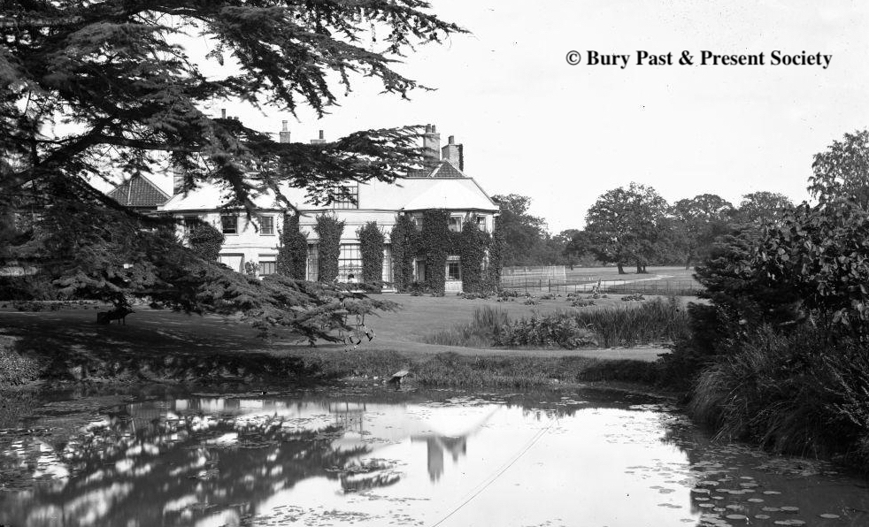
Hodskinson’s 1783 map shows a house on the site and the residence of William Wollaston Esq. It once fronted an early road linking the village to the remote fourteenth century Church of St Mary (Grade I) with its thatched roof. However, in 1818 the road was diverted slightly further south and away from the house by Edward Bridgman Esq., probably at the same time that he made major alterations to the earlier building, transforming it into the present colour-washed, white-brick Georgian country house, which David Elisha Davy in his Journal of Excursions through the County of Suffolk 1823-1844 described as ‘without any pretensions’.
The tithe map of 1843 shows the main range of the house facing east and overlooking parkland to the north, east and south-east. Parkland continued to the south and south-west to wrap around the house. Attached to the main range of the house was a connecting wing to an L-shaped, partly-enclosed, north-western garden area.
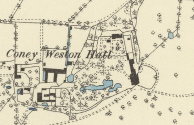
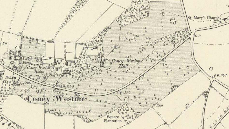
The Bridgman family continued to live at Coney Weston Hall during much of the nineteenth century, it descending to members of the Sawbridge family. In 1891 Capt. Edward Henry Sawbridge greatly enlarged the park and the estate. The 1883 OS map shows that two drives entered the parkland that was dotted with a few freestanding trees. The drive to the east, once the route of the old road, entered through a shelterbelt of trees before gently curving its way to the south entrance front of the house, although today it only survives as a cropmark. Still in use, the other from the west passed the entrance to Coney Weston House (Grade II) – thought to have been the dower house – to join the other drive at the entrance front.
By this time the partly-enclosed north-western garden area had been fully enclosed with the addition of surviving red-brick crinkle-crankle walls (Grade II) – also known as serpentine walls – to the south, west and a short section extending the original straight north wall westward. The curves of the walls are unusually wide and shallow, needing to be buttressed by slightly projecting plain pilasters to each outward curve. Within the garden were a perimeter path lined with trees and a central dividing path. A large glasshouse stood against the north wall with surviving back sheds behind and a further freestanding glasshouse, possibly an orangery, stood close to the north wall, with a yard to the east. The pleasure grounds were to the west of the house with a series of winding paths through shrubberies and towards a serpentine lake surrounded by a mixed planting of coniferous and deciduous trees. These led northward to the walled garden.
By the time of the 1901 census Coney Weston Hall was home to Frederick Stokes, a retired solicitor and his family plus twelve servants – a large number for such a property, even by the standards of the day. The following year the Coney Weston Hall Estate was for sale.
The layout of the pleasure gardens survived into the twentieth century and works carried out by a local builder from c. 1909 to 1917 reference a sundial, pergola, glasshouse and plans for a new plantation. Information supplied by Wendy and Gordon Hawksley confirm it was during this period that the property was owned by Harold Arthur Oliverson (1871–1916). Harold was an active member of the local community and Chairman of the Parish Council, who appears to have been responsible for a substantial amount of work in the gardens.The tranquillity of the site must have been shattered during World War II when the agricultural land to the north of the house became Knettishall Airfield, used by the US Air Force but eventually closed in 1957. The ruins of a few airfield buildings still stand in a landscape that has mainly reverted to arable use.
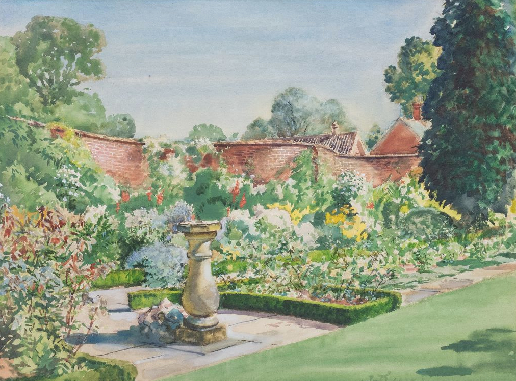
Two years after Harold’s death the Coney Weston Hall Estate was bought by Col. Henry Cleland Dunlop. Henry is said to have particularly enjoyed the gardens and after a long illness died peacefully in the garden he loved. Authorities on the Scottish artist William Bruce Ellis Ranken (1881–1941), Wendy and Gordon were able to confirm that a painting of a walled garden dated 1928 showing the sundial – presumably installed for Harold – box-edged flowerbeds and fine herbaceous borders fronting the crinkle-crankle walls was the work of William Ranken, a nephew of Henry.
In 1929 the estate was for sale as a whole or in lots and described in a sales advertisement in Country Life as an ‘Attractive Residential, Agricultural and Sporting Property’. The house was said to be situated in a picturesque park with several ‘well-placed plantations’ and shelterbelts with matured pleasure gardens and shrubbery walks.
At one time used as an hotel, in 2004 a local businessman bought Coney Weston Hall and its 607ha (1,500a) estate to use as his home. Today a USAF 388th Bomb Group War Memorial lies in the shelterbelt of trees beside the old eastern entrance and a new entrance has been established much closer to the house to the south-east. To the north-east and hidden behind a new shelterbelt of trees there is a small solar farm. Some nineteenth century parkland trees, serpentine lake and shelterbelt of trees have survived south and west of the house, although the intricate pleasure gardens and winding paths are now under grass. Albeit in need of some restoration, the crinkle-crankle walls have survived around the walled garden, which is presently uncultivated.
SOURCES:
Burke, Sir Bernard, A Genealogical and Heraldic History of the Landed Gentry of Great Britain and Ireland, 1921.
Bury Free Press, 25th August 1928.
Copinger, W. A., The Manors of Suffolk: The Hundreds of Babergh and Blackbourn, Vol. 1, 1905.
Country Life Supplement, April 27th, 1919.
Davy, David, Elisha, A Journal of Excursions through the County of Suffolk 1823-1844, published by Suffolk Records Society, 1982.
Kelly’s Directory of Suffolk, 1922.
Pike, William Thomas, East Anglia in the Twentieth Century: Contemporary Biographies, 1912.
Walford, Edward, The County Families of the United Kingdom, 1880, 1894.
White, William, History, Gazetteer, and Directory of Suffolk, 1844, 1874.
Census: 1841, 1851, 1861, 1871, 1881, 1891, 1901, 1911.
Maps:
1783 Hodskinson’s Map of Suffolk in 1783.
1843 (surveyed 1843) tithe map and apportionments.
1884 (surveyed 1882) OS map.
1905 (revised 1903) OS map.
1953 (revised 1950) OS map.
2024 Google aerial map (Imagery © Bluesky, CNES / Airbus, Getmapping plc, Infoterra Lts & Bluesky, Maxar Technologies, Map data © 2024).
Heritage Assets:
Suffolk Historic Environment Record (SHER): CNW 011, CNW 012, KNE 031.
Coney Weston Hall (Grade II), Historic England No: 1198681.
Church of St Mary (Grade I), Historic England No: 1031174.
Serpentine Walls Surrounding Kitchen Garden Immediately to the North West of Coney Weston Hall (Grade II), Historic England No: 1031175.
Coney Weston House (Grade II), Historic England No: 1198712.
Suffolk Record Office (now Suffolk Archives):
SRO (Bury St Edmunds) Q/SH/19. Diversion of public highway, January 1818.
SRO (Bury St Edmunds) HD526/34/3. Sales particulars for Coney Weston Hall Estate, 1902.
SRO (Bury St Edmunds) HC552/1/2/7. Records of R. Hogg and Son, Coney Weston Builders, for Coney Weston Hall, 1898–1917.
SRO (Bury St Edmunds) HA542/2/8/32. Photographs of gardens at Coney Weston Hall including pergola on south side of lake, undated c. 1913–18 and c. 1972–73.
Site ownership: Private
Study written: June 2024
Type of Study: Desktop
Written by: Tina Ranft
Amended: October 2025, March 2026
