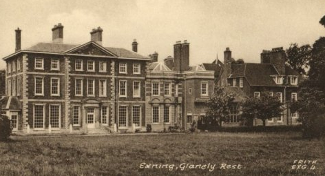
(previously Glanelly Rest)
Parish: EXNING
District Council: WEST SUFFOLK (previously Forest Heath)
TL 620 660
Not open to the public
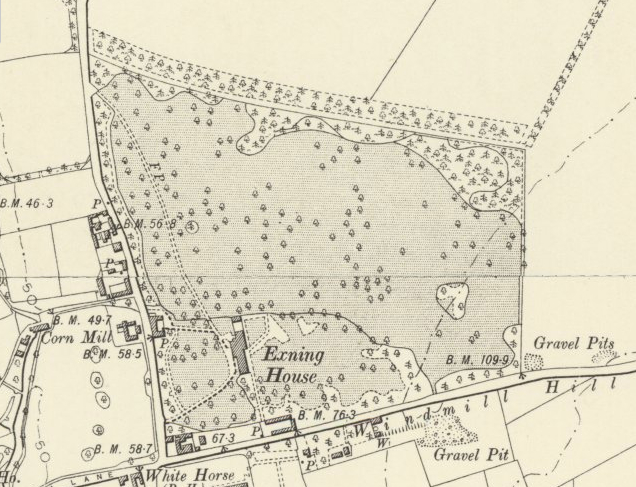
A former country house set in its own park, early-eighteenth century Exning House (Grade II*) is c. 2km (1ml) north of Newmarket in the village of Exning. It lies in the shallow valley of New River in an open flat landscape of arable fields and pasture for the equine industry. It is separated from Newmarket by the main A14 trunk road. Following the trend in Newmarket, racehorse trainers and jockeys were moving into the village during the latter part of the nineteenth century.
Shown on Kirby’s 1736 map, the house had been built two years earlier to English Baroque designs by the Scottish architect Andrew Jelfe for Francis Shepheard, a member of a wealthy landowning family. The estate was sold in 1794 to John Dobede who, following the enclosures of the early-nineteenth century, created its extensive 55ha (136a) park and planted shelterbelts and clumps of trees, primarily beech, lime and horse chestnut but unusually not oak. A number of freestanding trees surviving today. After the house was left in a ruinous condition by Henry, son of John Dobede, Capt. E. W. Baird bought the estate, including a model farm, in 1882. He employed the Arts and Crafts architect Philip Webb to alter and extend the house in 1886. The shipping magnate and racehorse owner William Tatum, who became the 1st Baron Glanelly, bought Exning House and the Le Grange Stables in Newmarket in 1919. After his death in 1942 the Gibson family of Lanwade Hall inherited the estate. World War II intervened and Exning House became the headquarters of No 3 Group, Bomber Command. Eventually the contents of the house were auctioned and the house converted into a home for the elderly that the family renamed Glanelly Rest. George Gibson Close, a sheltered housing complex with views of the rear of the house was built in the grounds. In 2005 the house was converted into a luxury gated residential complex.
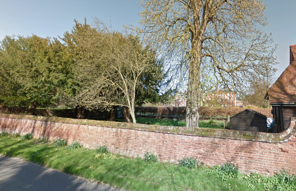
Attached to the rear of the house at the northern end are two surviving mid-eighteenth century gateways of red brick piers and limestone cappings, with decorative wrought iron gates and side-panels. At the north end a mid-eighteenth century red brick wall extends for 40m (131ft) with a short return. The gateways and brick wall are included in Historic England’s listing for the house. Paths once led alongside the wall, out into the park to the north and west, and southwards through a surviving mid-eighteenth century wrought iron garden gate with side panels and supporting brick gate piers (Grade II) to a walled garden enclosure adjacent to the road known as Windmill Hill. In the nineteenth and early-twentieth centuries the east section of this enclosure had a U-shaped series of lean-to glasshouses that were obviously meant to be seen as the owners and their guests made their way along the path from Windmill Hill to the house, with two further freestanding glasshouses in the western section. This walled garden complex has been lost to housing during the twentieth century.
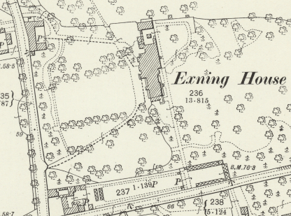

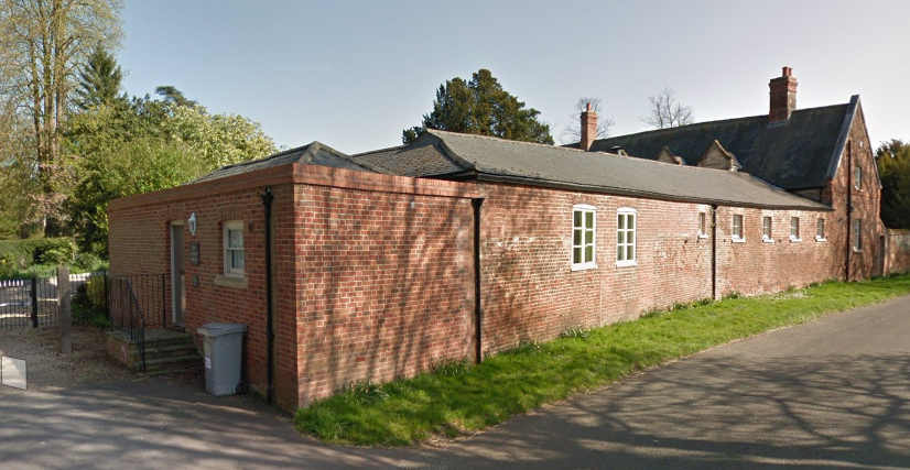
The courtyard stables and coach house with attached western boundary wall (Grade II) are mid-eighteenth century, but altered in the early-nineteenth century. The stables and coach house are now converted into a private residences. Further low boundary walls with brick gate piers at the south-western entrance are believed to be mid-eighteenth century and allow glimpses of the park and house frontage beyond. The drive sweeps towards the house and then returns to the road slightly further north where the old stables and coach house were situated at the entrance. Today a cricket ground and tennis courts lie in the north-west corner of the park, with new housing and the sheltered housing complex along the southern boundary. However a surprising area of nineteenth century parkland survives, as do the shelterbelts of trees to the north and west boundaries.

SOURCES:
Copinger, W. A., The Manors of Suffolk, Vol. 4, 1909.
Cromwell, T. K., Excursions in the County of Suffolk, 1818.
Page, Augustine, Topographical and Genealogical, The County of Suffolk, A Supplement to the Suffolk Traveller (of J. Kirby), compiled 1811 and published in 1844 by Page, Joshua.
Williamson, Tom, A Survey of Historic Parks and Gardens in Suffolk, 1993.
Williamson, Tom, Suffolk’s Gardens & Parks, 2000.
Forest Heath District Council, Exning Conservation Area Appraisal March 2012.
http://www.exning.net/
https://www.facebook.com/InternationalBomberCommandCentre/posts/exning-house-exning-suffolkalthough-not-an-actual-memorial-this-location-was-for/1714000118652224/
1885 (surveyed 1884) Ordnance Survey map
1902 (revised 1901) OS map.
1903 (revised 1901) OS map.
Suffolk Record Office:
Suffolk Record Office (Bury) HD 1325/2. 1881 Sales particulars, postcards etc.
SRO(Bury) EF 506/10/12. 29 July 1891 Sales particulars Exning House Estate in Exning and Burwell.
SRO(Bury) HD 1325/2 June 1912 Sales particulars Exning House Estate, Newmarket.
SRO(Bury) K 564/218. 1951 East elevation Glanelly Rest Home, Exning.
Heritage Assets:
Suffolk Historic Environment Record (SHER): EXG 081.
Glanelly Rest (Exning House) including Two Attached Gate Ways and Section of Garden Wall to North (Grade II*) Historic England No: 1374829.
Stables, Coach House and Boundary Wall to Glanelly Rest (Grade II) Historic England No: 1037648.
Gates and Gatepiers 60m South of the Glanelly Rest (Grade II) Historic England No: 1193748.
Site ownership: Private
Study written: January 2023
Type of Study: Desktop
Written by: Tina Ranft
Amended: May 2025
