Parish: GREAT FINBOROUGH
District Council: MID SUFFOLK
TM 015 580
Not open to the general public
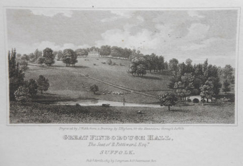
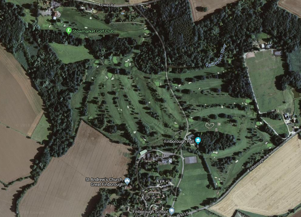
Now an independent day and boarding school, the former country house of Finborough Hall (Grade II) is c. 3.2km (2ml) west of Stowmarket and south of the Rattlesden River (also known as the River Rat), a tributary of the River Gipping that cuts through the central clay plateau of Suffolk. The house stands dominating the hillside as the land falls away to the north and the valley below and lies in the north-west corner of the parish of Great Finborough. Just outside the boundary of the park, St Andrew’s parish church (Grade II) and the village of Great Finborough lie behind the house to the south. Finborough Hall once stood in a c. 81ha (200a) park that is now the golf course for Stowmarket Golf Club.
OWNERS OF FINBOROUGH HALL
Although no trace of medieval buildings remains, it is believed that a manor house stood near the site of Finborough Hall during the Middle Ages. In the sixteenth century the manor of Great Finborough (Finborough Magna) was acquired by Henry Gilbert, whose son Sir John Gilbert built a new house. In 1656 it was bought by William Wollaston, the Wollaston family remaining Lords of the Manor of Great Finborough until 1794 when it was sold to Roger Pettiward, whose family owned the adjoining manor of Onehouse to the north. Roger died in 1833 and his widow Jane remained mistress of Finborough Hall for a further twenty-two years, even after her marriage to Admiral Sir William Hotham in 1835. After Jane’s death in 1855 it passed to her first husband’s great-nephew, Robert Bussell, who changed his name to Pettiward. In the same year he married Francis Catherine Nelson, grand-niece of Admiral Horatio Nelson. On the death of Robert in 1908 it passed to his nephew, Charles Terry, who followed tradition and adopted the Pettiward name. During World War I the house became a Red Cross Hospital. In 1936 Finborough Hall Estate of 692ha (1,711a), including eleven farms, was for sale in over one hundred lots. Eastern Electricity Board bought Finborough Hall and Park to use as its central office and sold the surrounding parkland to Stowmarket Golf Club in 1962. The house and gardens were sold in the 1970s when it became a school.
THE HOUSE, STABLES AND COACH HOUSE
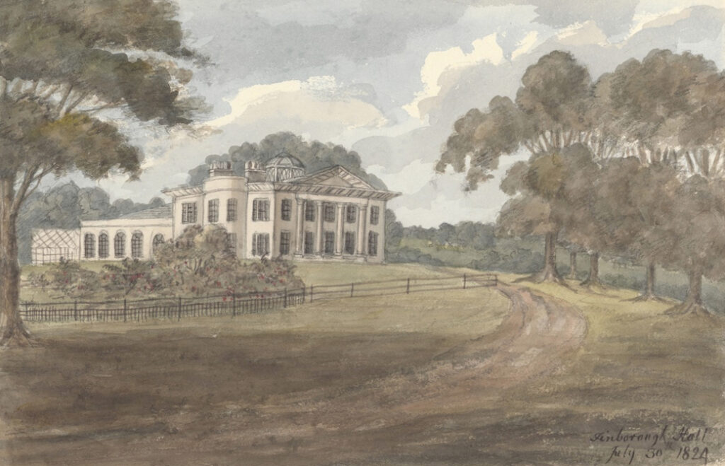
The neo-classical country house was built c. 1795 for Roger Pettiward by Francis Sandys, following a fire that destroyed the former house, which was widely thought to be Elizabethan, although Eric Sandon suggests a later mid-seventeenth century date. Based in Bury St Edmunds, Francis Sandys was a well-known local architect who had previously worked on Worlingham Hall and the new mansion at Ickworth. His original white brick house consisted of a simple square plan with central stairwell and dome. It had semi-circular bays to the north and south elevations and the original entrance with its columns and pediment was on the east side, although by 1824 the entrance had moved to the north facade. The west elevation had an orangery, garden room and a service wing.
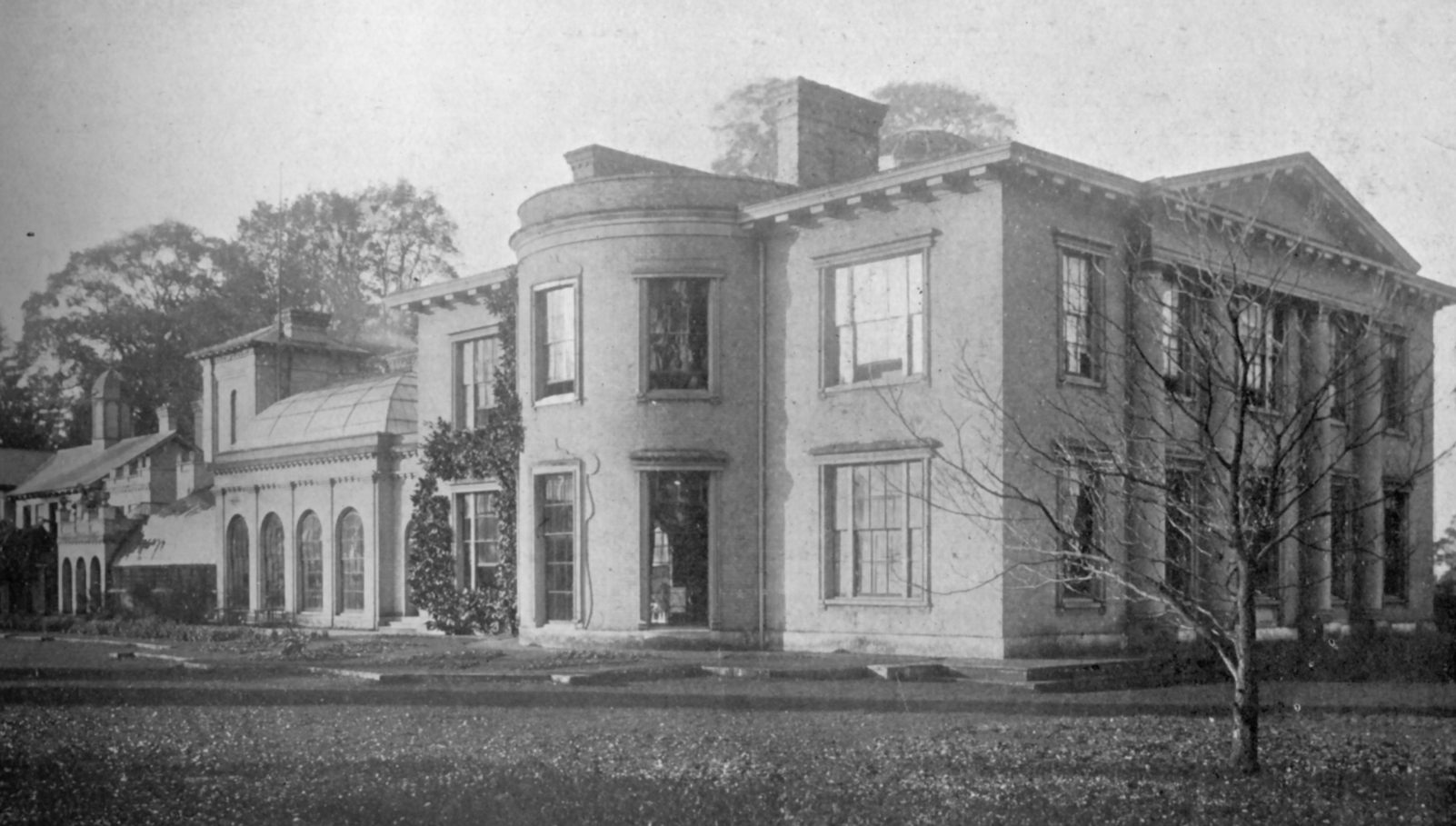
Much of Sandys’ original house has survived, but with later embellishment and major mid-nineteenth and twentieth century extensions to the west end, including the replacement of the orangery and addition of an Italianate tower. During the twentieth century Eastern Electricity added a large office wing, which was further extended by the school for classrooms and dormitories.
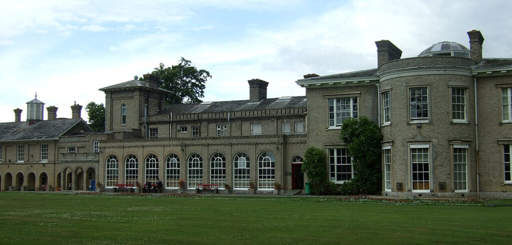
The surviving stable block and coach house (Grade II) lie south of the house and are attached to the remains of the walled kitchen garden. They are believed to date to the mid-eighteenth century but with later alterations and were converted to residential use c. 1980 and now in separate ownership.
THE PARK
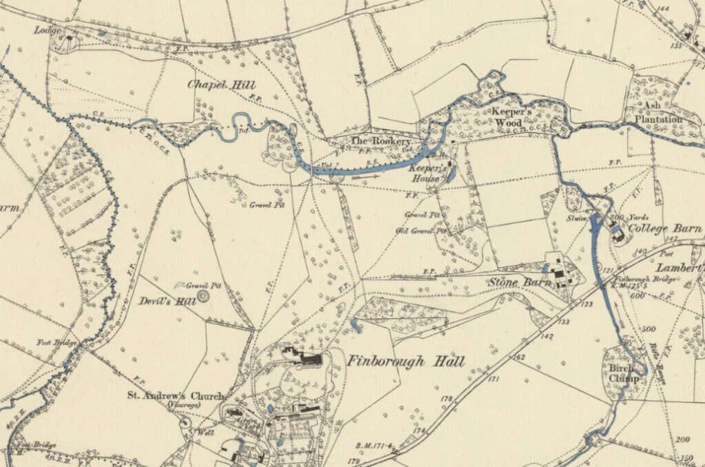
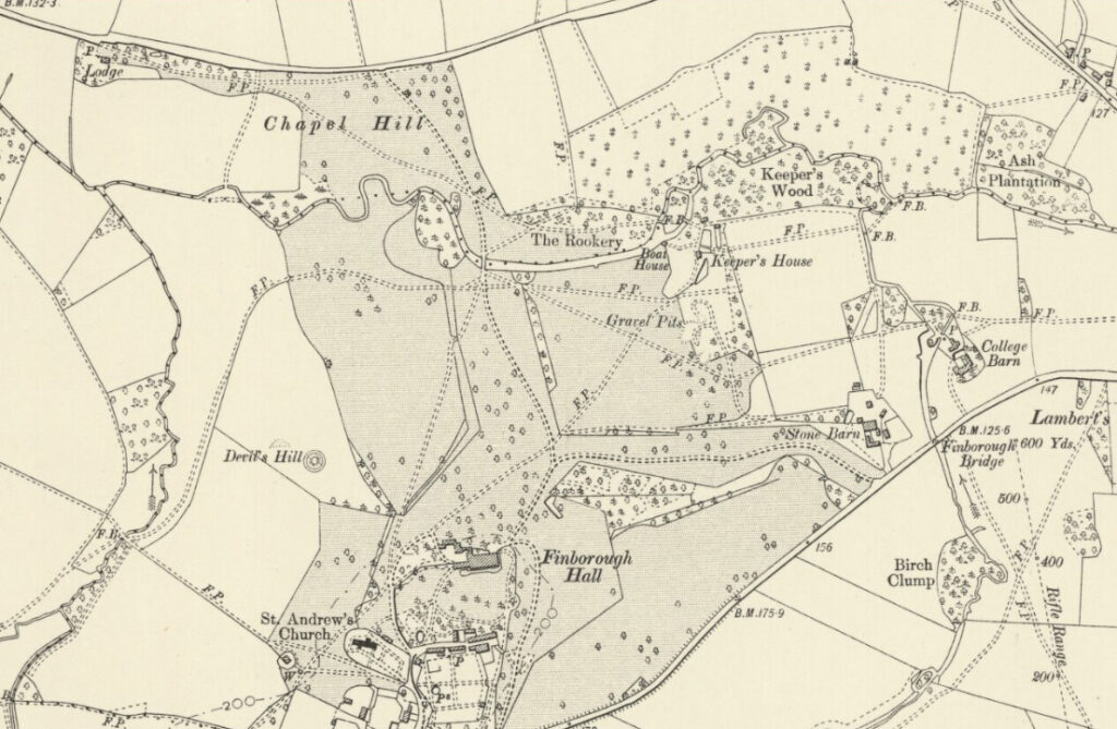
Hodskinson’s 1783 map of Suffolk shows Wollaston’s house standing in a park that is believed to have origins no earlier than the sixteenth century. The park extended from the house to east, west and north to beyond the Rattlesden River into the parish of Onehouse. At this time the Rattlesden to Stowmarket road, now known as Lower Road, formed the park’s northern boundary with woods lining the banks of the river. Off this road the map shows the main north-west entrance and drive that ran eastward and approximately parallel to the road before curving across an area named ‘Chapel Hill’ to bridge an ornamental linear lake – created by widening the river – before rising through the park and to the house on the hilltop to the south.
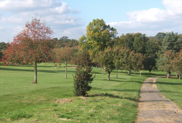
At the beginning of the nineteenth century the c. 81ha (200a) parkland was dotted with trees. Writing in the Arboretum et fruticetum britannicum of 1844, J. C. Loudon noted a number of coniferous trees in the parkland that he estimated to be in a range of sixty to eighty years old, which would date their planting to before the present house was built, thus during the Wollaston family’s ownership. He listed a yew at seventy years old and c. 15.25m (50ft) high, pines between sixty and seventy years old and cedars of seventy to eighty years old and grown to c. 8.3m (60ft) and c. 24.4m (80ft) high. These were supplemented by further surviving specimens that were planted during the nineteenth century. Many new freestanding and clumps of trees have been planted across the golf course since Stowmarket Golf Club took over ownership of much of the parkland in the 1960s.
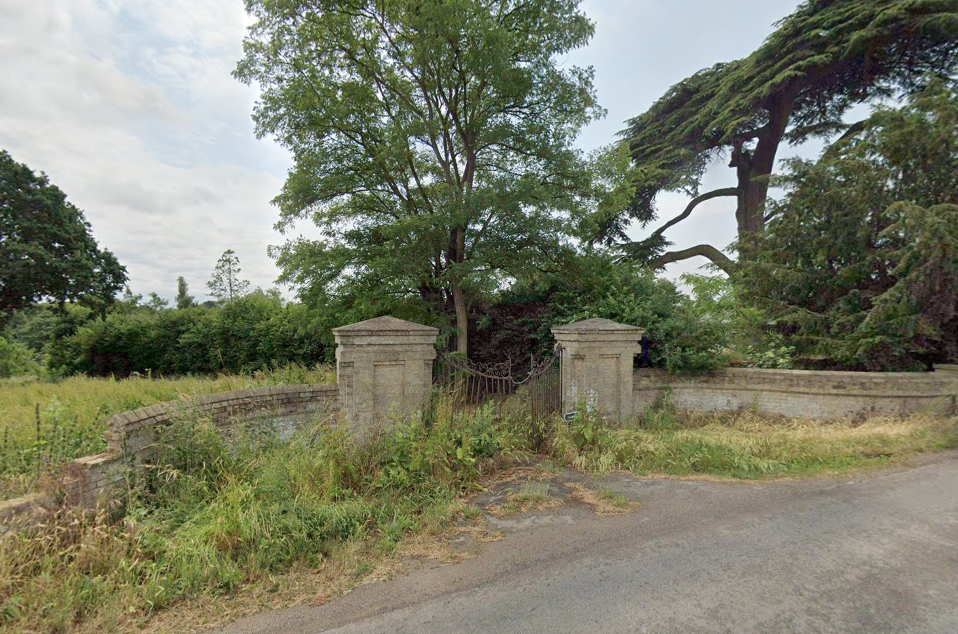
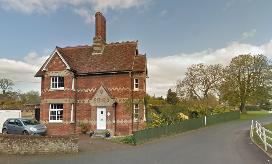
Today close to the entrance to the golf course and near Buxhall Fen Street, Bury Lodge (Grade II) lies at the site of the old north-west entrance. The lodge’s listing suggests it is a nineteenth century re-modelling of a much earlier cottage and would therefore be the work of the Pettiward family, possibly early in the century when Roger Pettiward was enhancing his park after buying the estate from the Wollastons. Unfortunately there is scant detail on the 1840 tithe map to help give a more precise re-modelling date. By the time of the 1885 OS map the main entrance had moved further east along the road and the north-west drive had become a footpath. The drive from the new entrance took a direct route southward to the bridge, although it is now a public footpath. However, the unused remains of low, decorative wrought iron entrance gates with two white brick gate pillars set within a curving indent of brickwork, possibly with origins dating back to the mid-nineteenth century, can still be seen. It appears that this entrance was without a lodge until the early-twentieth century when North Lodge was built a slight distance to the east sometime between 1905 and 1927.
To the west of the house the land drops down to a tributary of the Rattlesden River that flowed through the western section of the park and where a surviving mound, known as Devil’s Hill, lies. Suggested as the remains of a tumuli, diaries of the Pettiward family dating from the 1700s suggest the mound was constructed from mud dredged from the river when it was widened to form the lake during the eighteenth century. Roger Pettiward is believed to have added the surviving brick monument and simple c. 3.5m (11.5ft) high column on its summit c. 1800, soon after his small classical house was built. At the eastern end of the ornamental lake the 1884 OS map shows a boathouse and nearby keeper’s cottage nestled in woods that lined the riverbank within the park with its numerous criss-crossing tracks and footpaths. Apart from a slight contraction of the park with the loss of land to the west and east by 1905, it remained much as it had been at the end of the nineteenth century until the parkland was sold to Stowmarket Golf Club in 1962.
Today some of the parkland to the east of the house has been retained for school buildings and sporting facilities and the south-west section is in agricultural use. Trees now cover Devils Hill mound with clumps of trees and golf bunkers over most of the rest. A number of public footpaths criss-cross the golf course.
PLEASURE GARDENS
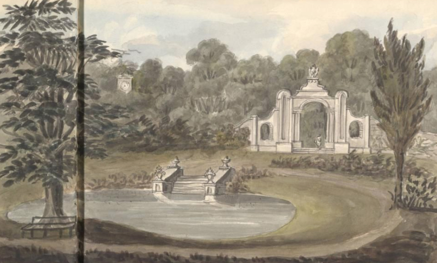
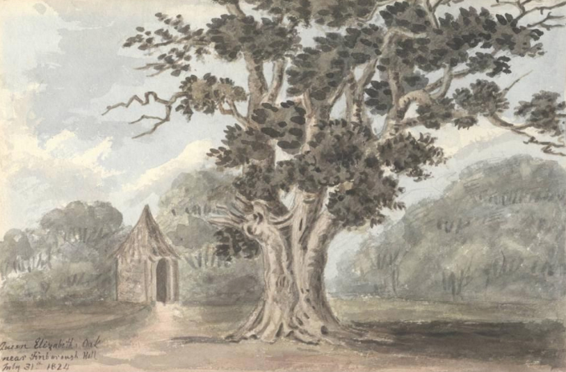
At the end of the nineteenth century a garden terrace stretched along the whole of the south elevation of the house. Beyond was an area of pleasure gardens with lawn dotted with specimen trees and main circular path leading to a shrubbery. Within the shrubbery were numerous paths and an oval ornamental pond. A sketch by Lady Anne Rushout (1768–1849) of Wanstead Grove dated 1824 shows a ha-ha with semi-circular outdent separating the garden from parkland on the east side. Other sketches included a rustic summerhouse beside an ancient tree named the ‘Elizabeth Oak’.
In 1828 Lady Anne made a return visit to Finborough and produced further sketches, one showing a grand arched entrance to the ornamental pond. In the same year Edward Mogg and Daniel Paterson writing in Paterson’s Roads… described an ‘embowered walk’ winding behind the house to the church, which would have formed part of the pleasure gardens in this area. These were described by Henry Davy in Views of the seats of noblemen and gentlemen in Suffolk, 1824–26, as ‘luxuriantly ornamented with evergreens, and laid out in good taste’.
A tunnel once ran beneath the south lawn connecting the south wing to the stable block. This consisted of a trench lined and roofed with brick that was lit at intervals by skylights to allow servants to cross the gardens without being seen by the family. It was filled-in during the twentieth century, although the entrances are believed to still be seen near the coach house and end of the orangery. Today, whilst the land fronting the north elevation has become a car park with new buildings replacing some gardens to the west, surviving low brickwork traces the outline of the garden terrace, the southern lawn is still dotted with mature trees, and part of the old shrubbery and the eastern ha-ha survive.
WALLED KITCHEN GARDEN
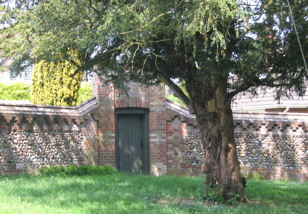
An irregularly-shaped walled garden lay immediately south of the stable block and coach house. Although of unknown date, its origins are likely to be contemporary with the mid-eighteenth century stables and were said to cover c. 1.6ha (4a) in the 1820s. In the late-nineteenth century it had lean-to glasshouses facing south along the north wall with entrances on the east, west and south sides, those to south and east leading to slip gardens with a path back to the house. In 1831 Loudon wrote of the ‘Fine vines’ growing at Finborough Hall, although it is not clear if this refers to those growing in glasshouses within the walled garden or the conservatory attached to house. Inside the walled garden were a perimeter path with cross-paths. A low ornamented brick and flint wall with tall entrance gates separated the southern slip garden from the village, although it is unclear if it was contemporary with the rest of the garden or a later addition. Map evidence shows the slip garden to have been an orchard.
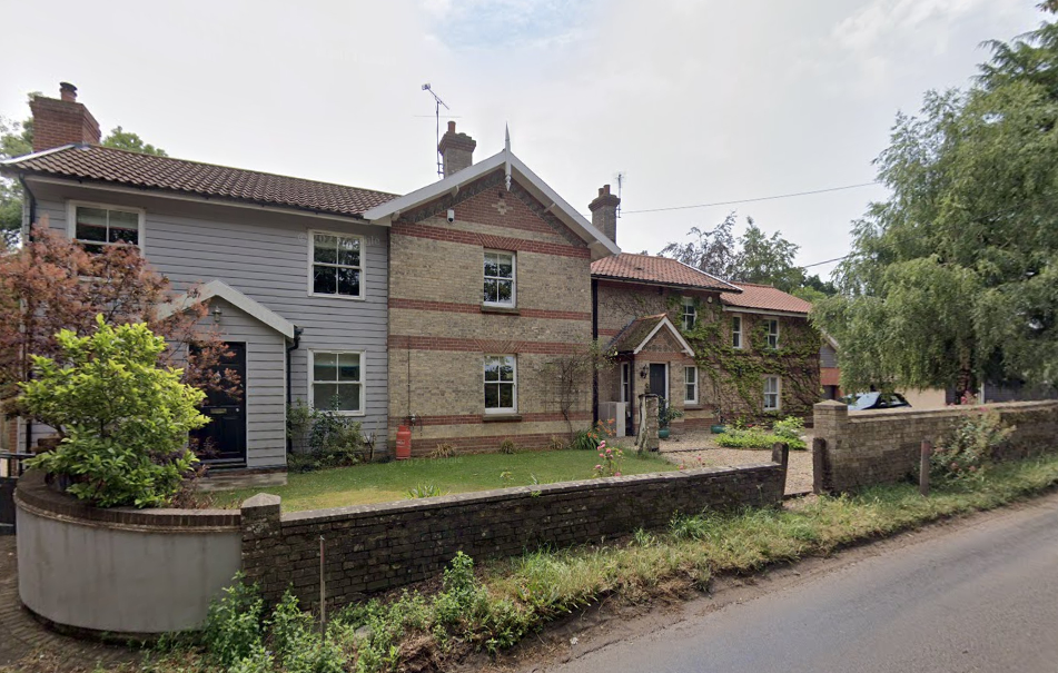
During the twentieth century a number of houses were built within the garden, probably at a similar time to the conversion of the stables and coach house. Although some walls were demolished or breached to make way for entrances and a road, a number of the properties have boundaries marked by the old or reconstructed walls and the development has been sympathetically designed to retain a number of sections of wall.
SOURCES:
Barker, H. R., West Suffolk Illustrated, 1907.
Birch, Mel, Suffolk’s Ancient Sites Historic Places, 2004.
Copinger, W. A., The Manors of Suffolk, Vol. 6, 1910.
Country Life Vol. 80, 1936.
Cromwell, Thomas Kitson, Excursions in the County of Suffolk, Vol. 1, 1818.
Davy, Henry, Views of the seats of noblemen and gentlemen in Suffolk, 1824–26.
Land, Dr Stephen, K., former Deputy Headmaster of Finborough School, with additions by M. R. Kauffman, Head of English History of Finborough Hall (School website accessed October 2020).
Loudon, John, Claudius, The Gardener’s Magazine, 1831.
Loudon, John, Claudius, Arboretum et fruticetum britannicum, or: The trees and Shrubs of Britain, native and foreign, hardy and half-hardy, pictorially and botanically delineated…, 1844.
Mogg, Edward and Paterson, Daniel, Paterson’s Roads; Being an Entirely Original And Accurate Description of All The Direct And Principal Cross Roads In England and Wales, 18th Edition, 1828.
Page, Augustine, Topographical and Genealogical, The County of Suffolk, A Supplement to the Suffolk Traveller (of J. Kirby), compiled 1811 and published in 1847 by Page, Joshua.
Sandon, Eric, Suffolk Houses. A Study of Domestic Architecture, 1977.
Williamson, Tom, Suffolk’s Gardens and Parks, 2000.
http://www.suffolklandscape.org.uk/landscapes/Rolling-valley-claylands.aspx (accessed June 2020).
Hodskinson’s Map of Suffolk in 1783.
1840 tithe map and apportionment.
1884 (surveyed 1884) Ordnance Survey map.
1905 (revised 1903) OS map.
1927 (revised 1925) OS map.
1949 (revised 1938) OS map.
1953 (revised 1950) OS map.
2024 Google aerial map (Imagery © Bluesky, CNES / Airbus, Getmapping plc, Infoterra Lts & Bluesky, Maxar Technologies, Map data © 2024).
Heritage Assets:
Suffolk Historic Environment Record (SHER): FNG 003, FNG 013, FNG 020, FNG 072, ONS 015.
Finborough Hall, St Georges School, (Grade II), Historic England No: 1198011.
The Coach House (Grade II), Historic England No: 1352161.
Church of St Andrews (Grade II), Historic England No: 1032977.
Bury Lodge (Grade II), Historic England No: 1032992.
Ludlow Castle Archives. Taken from the website Wicked William, Resources for study of the life and times of William-Pole-Tylney-Long-Wellesley (1788–1857). http://www.wickedwilliam.com/tag/ludlow-castle/ (accessed June 2020).
Suffolk Record Office (now Suffolk Archives):
SRO (Ipswich) HD1847. Evidence of title to property in Great Finborough, 1702.
SRO (Ipswich) HD1847/2. Finborough Hall and Park, White Horse Inn…, conveyance from William Woolaston and Robert Carss to Roger Pettiward, nd.
SRO (Bury St Edmunds) K997/69/14. Red Cross Hospital, Finborough Hall, view across the lawn to house, 1914–19.
SRO (Bury St Edmunds) K997/109/7. Photograph of a man in bed at Finborough Hall Red Cross Hospital, 1914–19.
SRO (The Hold) HD2833/1/SC159/1. Finborough Hall catalogue of the major portion of the contents of the mansion, comprising garden effects and plants, game keeper’s equipment…, 1935.
SRO (The Hold) HD2833/1/SC159/11. Finborough Hall Estate sales particulars, 26 June 1936.
Site ownership: Privately owned educational establishment
Study written: May 2024
Type of Study: Desktop/site visit to the original parkland and a house within walled garden
Written by: Tina Ranft
Amended:
