Parish: FRISTON
District Council: EAST SUFFOLK (previously Suffolk Coastal)
TM 409 607
Not open to the public
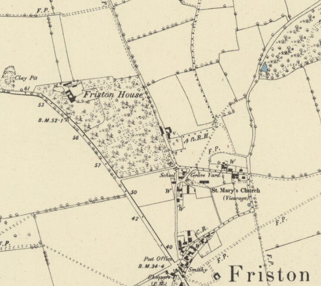
The rural village of Friston lies on rising ground overlooking the River Alde to the south, c. 6.5km (4mls) from the seaside town of Aldeburgh to the east. The early-nineteenth century Friston House (Grade II) stands close to St Mary’s Church (Grade II*) on the northern edge of the village and beside the road to Sternfield, now the B1121, that leads to the market town of Saxmundham c. 4km (2.5mls) to the north-west. To the north of the site there was once an extensive moor used from medieval times for common grazing. Since the nineteenth century it has gradually been converted to arable, although a number of place names remain as a reminder of its existence. To the north of the village is the ancient woodland of Grove Wood.
The manor of Friston was the property of Snape Priory until Cardinal Wolsey acquired it in 1524. It passed through a number of owners including Sir James Bacon and the Bacon family, Sir Henry Johnson c. 1682 and then descending to the Earls of Strafford who owned it throughout the eighteenth century. On the death of the Third Earl in 1799 it was inherited by his cousin Richard William Howard Vyse of Stoke Place, Slough, Buckinghamshire, who owned much of the manor including Friston House at the time of the tithe apportionment in 1847. At this time the small country house was home to Revd Robert Baker, serving as the vicarage because Friston did not have its own and only 0.8ha (2a) of glebeland. Nearly twenty-five years later the Revd Baker and his family were still there. It ceased to be used as the vicarage at some time during the next twenty years, by 1891 becoming the home of retired Col. Charles Sewell, with the clergyman living in Snape. The Sewell family remained at Friston House into the twentieth century.
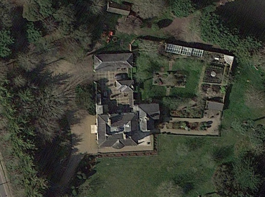
A map dated 1819 of Moor Farm to the north shows the original road layout in this area and was prior to the building of house on the site. On the tithe map, surveyed in 1839, the site was occupied by a simple square house, which, although suggested as dating from c. 1848, is more likely to be of a slightly earlier date, or perhaps a remodelling of an existing Georgian house. Today the house has two floors, sash windows and central entrance doorway with Tuscan columns, fanlight and panelled door facing approximately west. There are later additions to the rear and by 1884 a courtyard between the house and service wings to the north-west had been added.
The tithe map shows the Revd Baker’s house surrounded by a small area of gardens with the entrance off the road to Sternfield. To the south-east there were densely wooded pleasure grounds – named ‘Blacksmith Walk (in part)’ on the map and probably related to the blacksmith shop nearby – criss-crossed by a number of paths. The word ‘walk’ often refers to an area of rough grazing, suggesting the area had recently been converted to pleasure grounds but still retained its old name. The 1884 OS map gives a more detailed picture of a mixed woodland of deciduous and coniferous trees with a perimeter path leading to an entrance close to the church and linked to other paths radiating out from the centre of the wood. By this time there were two entrances from the road creating an in-and-out drive.
There was also a walled enclosure to the rear suggestive of a kitchen garden with a building, probably a lean-to glasshouse, against the northern wall facing south. Very few changes to the grounds have taken place since that time, although by 1928 ‘Blacksmith Walk’ had lost its paths and been renamed Friston House Wood. What appears to be an orchard in a narrow subdivided field to the north of the house had also been added, part of which is now home to a swimming pool.
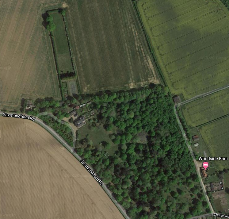
When the property was for sale in 2012 it was said to stand in grounds of over c. 15ha (37a) with a formal garden surrounding the house, lawns dotted with specimen trees to the south, a partly-walled garden that is now mainly laid to lawn with some formal planting and lean-to glasshouse in the same position as that shown on the 1884 OS map. The parkland has numerous mature trees and two ponds to the south-east.
Friston House is severely threatened by the cumulative effects of the energy and infrastructure projects of Sizewell C and the proposed National Grid Lionlink and Sealink pipelines. It is less than 500m (1,640ft) south of a planned new substation that would be widely visible from the grounds of the house, which was noted in a 2018 archaeology and cultural heritage assessment for Scottish Power as ‘could harm the significance of this asset’. Further proposed transformer stations on a site east of Saxmundham also have the potential to be visible from the grounds of Friston House. The scale of these projects will result in severe disruption during the lengthy construction periods and result in the replacement of fields in a rural setting by a massive industrial landscape.
SOURCES:
Birch, Mel, Suffolk’s Ancient Sites Historic Places, 2004.
East Anglia ONE North Offshore Windfarm. Appendix 24.3. Archaeology and Cultural Heritage Desk Based Assessment, Headland Archaeology for Scottish Power Renewables.
White, William, Directory of Suffolk, 1844.
Savills Sales particulars c. 2012.
History of Parliament, https://www.historyofparliamentonline.org/volume/1690-1715/member/johnson-sir-henry-1659-1719 (accessed November 2020)
https://heritage.suffolk.gov.uk/media/pdfs/friston.pdf (accessed February 2025).
http://friston.onesuffolk.net/home/our-village/history/ (accessed June 2020).
Census 187, 1891, 1901, 1911.
Hodskinson’s Map of Suffolk in 1783.
1847 (surveyed 1839) tithe map and apportionment.
1884 (surveyed 1882) Ordnance Survey map.
1905 (revised 1903) OS map.
1928 (revised 1925) OS map.
© 2020 Google Earth.
© 2022 Google Earth.
Heritage Assets:
Friston House (Grade II), Historic England No. 1215909.
St Marys Church (Grade II*), Historic England No. 1287864.
Site ownership: Private
Study written: February 2025
Type of Study: Desktop
Written by: Tina Ranft
Amended:
