(site of)
Parish: GREAT BEALINGS
District Council: EAST SUFFOLK (previously Suffolk Coastal)
TM 230 488
Not open to the public
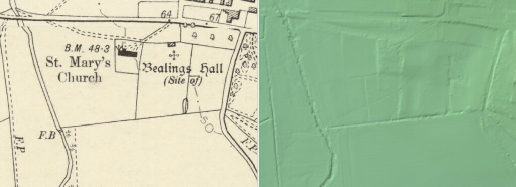
Beside water meadows and marshland of the River Lark, the site of the original Great Bealings Hall is next to St Mary’s Church (Grade II*) in the parish of Great Bealings c. 3.5km (2mls) west of Woodbridge. The site is slightly remote from the village, its two settlement areas lying to the east (Boot Street) and to the south-east (Lower Street). The house was demolished towards the end of the nineteenth century.
The manor of Great Bealings, held previously by the de Peche and de Tuddenham families, was owned by Margaret Bedingfield c. 1474. Edmund Bedingfield sold it to John Clench, a Justice of the Queen’s Bench, in 1585. It stayed in the family for the next one hundred years until c. 1680 when Edmund Clench sold to Thomas Wood, Bishop of Lichfield and Coventry, and then passed to his nephew, Henry Wood (al. Webb) on his death in 1690. In 1709 Henry’s son, another Henry, inherited the manor but due to debts sold it to John Pitt of Crows Hall, Debenham. It was later sold to James Bridges, during whose ownership the Hall became a farmhouse. The manor passed to James’s widow, Lady Jane, who sold it to Sir John Major. On his death in 1781 the manor was inherited by his daughter Anne, who was married to Sir John Henniker (later Lord Henniker). It is believed the Hall was demolished soon after 1783 when it is still shown on Hodkinson’s map of Suffolk. By 1839 the name ‘Great Bealings Hall’ had been transferred to a house on the opposite side of the road, which is known today as Bealings Hall (Grade II).
To the south and east of the church, areas of terraced ground bisected by the churchyard are thought to be the house platform and gardens of the old manor house with sixteenth century bricks, perhaps from a retaining wall, found in the area. Further south on the north bank of the river, additional earthworks have appeared as cropmarks on aerial photographs taken in 1992 that may represent field boundaries or possibly parts of the gardens to the Hall. An undated map of c. 1700 shows the house surrounded by a number of small courtyards within which are three large canals with a wilderness garden beyond. The layout of the canals suggests they may have been created from a substantial moat, although they have long since been filled in. Today a substantial early red brick wall still stands on the boundary between the church and the site of the old Hall. Parallel to the road that runs east to west is an avenue of mature lime trees lining a public footpath to the church and the manorial site. The tithe map dated 1838 and associated with the 1839 tithe apportionment clearly marks this route, which was probably in existence for many centuries before and would have also served as an entrance drive to the demolished house.
SOURCES:
Birch, Mel, Suffolk’s Ancient Sites Historic Places, 2004.
Davy, David, Elisha, A Journal of Excursions through the County of Suffolk 1823-1844, published by Suffolk Records Society, 1982.
Copinger, W. A., The Manors of Suffolk, Vol. 3, 1919.
Cromwell, Thomas, K., Excursions in the County of Suffolk, Vol. 1, 1818.
(Combined parish councils) Great Bealings, Little Bealings and Playford Parish Plan, April 2009.
Great Bealings Parish Council, Great Bealings Neighbourhood Plan, 2016–2030, March 2017.
White, William, Directory of Suffolk, 1844.
Williamson, Tom, Suffolk’s Gardens and Parks, 2000.
Hodskinson’s Map of Suffolk in 1783.
1839 (tithe map 1838) and apportionment.
1884 (surveyed 1880–81) Ordnance Survey map.
1905 (revised 1902) OS map.
2023 Google aerial map (Imagery © Bluesky, CNES / Airbus, Getmapping plc, Infoterra Lts & Bluesky, Maxar Technologies, Map data © 2022).
Heritage Assets:
Suffolk Historic Environment Record (SHER): BEG 002, BEG 043, BEG 054.
Church of St Mary (Grade II*). Historic England No: 1030752.
Bealings Hall, Hasketon Road (Grade II) No: 1284050.
English Heritage Project Ref: 3987, The Aggregate Landscape of Suffolk: The Archaeological Resource, Interim report for Aerial Survey component Areas One & Two: The Felixstowe Peninsula, PDF version 2011.
Suffolk Record Office (now Suffolk Archives):
SRO (Ipswich) HA116/4/37. Deeds relating to Great Bealings Hall, c. 1673–1689.
SRO (Ipswich) HA116/6/1/17. Part of parchment plan showing the estate [of the Pitt family] at Great Bealings, nd 18th century.
SRO (Ipswich) HA1/B/E/1/5. Assignment by William Clench of Great Bealings gent. to Robert Theobald of Barking Esq. 1 January 1682–83.
SRO (Ipswich) HA116/4/1/41. Bundle of deeds, letters and wills relating to the Manor of, and an estate in, Great Bealings, 1746.
SRO (Ipswich) HD 417/5. A plan of Great Bealings Hall estate in Great and Little Bealings & Playford…, the property of the Rt. Hon. Lord Henniker, nd 19th century.
SRO (Ipswich) HA116/5/5/1/70. Lease of Bealings Hall Farm in Great Bealings, 5 January 1803.
SRO (Ipswich) HA116/5/5/1/138. Lease of Bealings, Great Bealings, 8 October 1818.
Site ownership: Private
Study written: November 2023
Type of Study: Desktop
Written by: Tina Ranft
Amended:
