Parish: GROTON
District Council: BABERGH
TL 957 422
Not open to the public
In the rural parish of Groton lying on the Suffolk claylands plateau, the small village of Groton is c. 9.5km (6mls) west of Hadleigh and north of Boxford. The centre of the village consists of a few houses near the fifteenth century Church of St Bartholomew (Grade I) next to Groton Hall (Grade II)*, which dates to the sixteenth century.
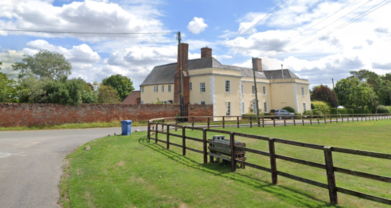
Probably with sixteenth or seventeenth century origins, the timber-framed and plastered Groton Place (Grade II) has eighteenth century external features and lies north of the village centre. Believed to have originally been called ‘Edmunds’, the land and buildings on the site were owned by Bury St Edmunds Abbey before being acquired by Richard Doggett in the early-sixteenth century. It passed down through the family until John Winstrop, who had been granted the manor of Groton from the crown, bought the house and land and appears to have made it into the manor house for Groton. It is unclear if John leased out Groton Place or lived there before emigrating to Massachusetts in the Great Puritan Migration of 1630 when he sold the property to the local Waring family. It had a number of further owners until it was sold towards the end of the eighteenth century when it was remodelled in the Georgian style. By 1806 it was owned by Isaac Strutt, Esq., a farmer from a local family. It passed to his son Walter who in the 1851 census is said to be farming 101ha (250a) although by the time of the 1881 census he was a ‘retired farmer’ but still living at Groton Place. By 1919 Groton Place and its estate was for sale and included the house, various cottages and farmland in Groton and neighbouring parishes. Having previously ceased to be a farmhouse, in 1986 the house had c. 7.7ha (19a) of land and farm buildings had been renovated and converted into six residential properties.
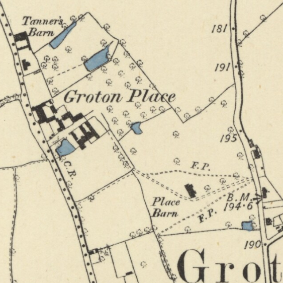
Shown as an un-named house on Hodskinson’s 1783 map, by the time of the 1838 tithe map farm buildings can be seen lying south of Groton Place with a trapezoid-shaped walled garden attached to the north wing of the house. The map shows this laid out with outer stippled area enclosing perimeter and cross-paths surrounding beds. The stippling probably represents grass. An enclosure to the east is named ‘kitchen garden’ on the tithe apportionment, suggesting an ornamental garden had been created within the walled garden. Further east and south were orchards and a ‘fishpond’ that was surrounded by a regularly-shaped area of planting, perhaps a decorative garden feature utilising an earlier pond. A small area of parkland lay to the south-east with a surviving sixteenth to seventeenth century timber-framed barn (Grade II) lying within it. By the time of the 1885 OS map a small lean-to glasshouse had been added to the north-east corner of the walled garden, although this had gone by the end of the century. The earlier kitchen garden enclosure had been incorporated into a larger area of parkland dotted with a few trees and crossed by a path leading from the walled garden to the pond, which had lost its former formal layout.
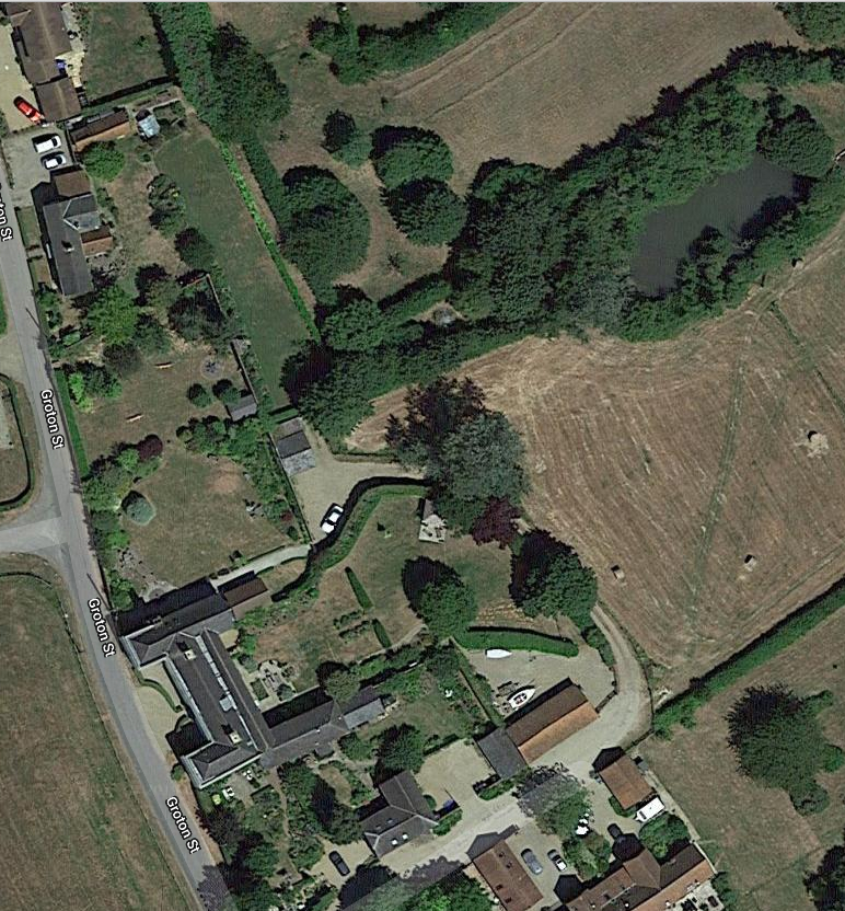
The garden layout changed little until ownership of the house and farmland were separated in the twentieth century. Today the red brick walled garden survives as the garden for the property created from the north wing of Groton Place. This is now mainly laid to grass with a few trees and shrubs around the perimeter and also dividing it into two sections. The fishpond and surrounding woodland also survive, although the orchards and parkland are now under arable cultivation.
SOURCES:
Bremer, Francis J., John Winthrop. America’s Forgotten Founding Father, 2005.
Copinger, W. A., The Manors of Suffolk: The Hundreds of Babergh and Blackbourn, Vol. 1, 1905.
Country Life, Vol. 177, 1985.
Cowell, Henry J., ‘John Winstrop (1588–1649)’, in Suffolk Institute of Archaeology and History, Excursions, Vol XXV Part 1, 1949.
Cuttings from newspapers, etc. relative to the county of Suffolk, 1806–1847.
Doggett, Richard, Richard Doggett’s House, December 2005, www.doggettfam.org/doggetthouse.htm, (accessed April 2019).
Kelly, E. R., Post Office Directory of Norfolk & Suffolk, 1875.
Page, Augustus, Supplement to the Suffolk Traveller [of J. Kirby] or Topographical and Genealogical Collections, Concerning That County, 1844.
White, William, Directory of Suffolk, 1844.
Restoration by Dakin Estates, http://www.dakinestates.co.uk/ (accessed April 2019).
Groton Place and Groton Hall, https://www.millersville.edu/~winthrop/news2.html (accessed April 2019).
Census: 1851, 1871, 1881.
1783 Hodskinson’s Map of Suffolk in 1783.
1838 (surveyed 1838) tithe map and apportionments.
1885 (surveyed 1885) OS map.
1905 (revised 1902) OS map.
1927 (revised 1924) OS map.
1948 (revised 1938) OS map.
2024 Google aerial map (Imagery © Bluesky, CNES / Airbus, Getmapping plc, Infoterra Lts & Bluesky, Maxar Technologies, Map data © 2024).
Heritage Assets:
Church of St Bartholomew (Grade I), Historic England No: 1194685.
Groton Hall (Grade II*), Historic England No: 1194685.
Groton Place (Grade II), Historic England No: 1194685.
Place Barn (Grade II), Historic England No: 1037283.
Suffolk Record Office (now Suffolk Archives):
SRO (Ipswich) HD4084/312. Pedigree chart of the Strutt family of Groton, 1747–1878, with associated correspondence.
SRO (Ipswich) HE 402/2/1919/12. Sales Particulars of Groton Place Estate, 11 November 1919.
SRO (Ipswich) K681/1/204/5 and 6. Colour photographs of barns conversion, 1986.
Site ownership: Private
Study written: February 2024
Type of Study: Desktop
Written by: Tina Ranft
Amended:
