(previously known as The Grove and Grove House)
Parish: YOXFORD,
District: EAST SUFFOLK (formerly Suffolk Coastal)
TM 390 689
Not open to the public
One of three landscape parks surrounding the village of Yoxford, Grove Park (Grade II) is c. 40km (25mls) north of Ipswich in a small area known as the ‘Garden of Suffolk’. The seaside village of Southwold is c. 13km (8mls) to the north-east. The River Yox runs from the west through the village, becoming the River Minsmere as it flows into the North Sea to the east. On the edge of the central Suffolk clay plateau, Grove Park is on the western side of the village on a gently-sloping site down to the river. The house has remained remarkably unchanged since it was built in the late-eighteenth century, although the extent of its parkland has reduced over the last two hundred years.
GROVE PARK OWNERS AND OCCUPIERS
The original sixteenth century house on the site was known as ‘Burtons’ and said to have always been ‘one of the most important houses of the parish’. Eleazer Davy bought the estate in 1772 from the Hon. Mrs Henrietta Clutterbuck, widow of Thomas Clutterbuck, MP and Treasurer of the Navy.
Eleazer immediately began rebuilding the old mansion, possibly to designs of James Wyatt. At this time he was a long-term tenant of the former Ubbeston Hall, c. 9km (5.5mls) where he is believed to have been living between c. 1748 to 1799.
Sheriff of Suffolk in 1770, Eleazer was related through the marriage of his step-daughter to the Earl of Stradbrooke, Sir John Rous of Henham Hall, and had connections to other powerful Suffolk families including his neighbours the Blois family of Cockfield Hall. By 1799 he owned lands in Yoxford, Ubbeston, Wissett, Westhall and Walberswick.
Known variously as ‘The Grove’ and ‘Grove House’, Grove Park appears to have been tenanted in 1788 by the spinster Frances Juliana Warter Wilson (c. 1758–1790), who went on to marry Sir John Rous of Darsham Hall.
On the death of Eleazer in 1803, The Grove Estate was inherited by his nephew David Elisha Davy (1769–1851), the Suffolk traveller, historian and antiquary who came from a farming family in Rumburgh, a small village north-west of Halesworth. His uncle had taken a keen interest in David’s education. Although ordained – spending a time as curate of Theberton and two years in Yoxford –David realised the church was not for him.
After inheriting, David made The Grove his home and mixed in the local high society, becoming a magistrate and receiver-general for Suffolk. However, he had inherited debts from his uncle and needed to borrow from his bank, Messrs. Gurney of Norwich. At the same time there was a slump in property values and he was eventually forced to put The Grove into the hands of the bank as security for further advances.
The social embarrassment and lack of finances led David to leave The Grove, moving to a house in Ufford in 1822 offered to him by his friend Charles Brooke, curate at Ufford. This house stands beside the entrance to Ufford Place and is now known as Ufford House. Even though The Grove was returned to him by the bank in 1843, David stayed in Ufford until his death in 1851. During this period the house in Yoxford was renamed Grove House and tenanted by the Rt. Hon. Thomas Manners Sutton, First Baron Manners, a lawyer and politician who died in 1842, leaving Grove House untenanted that year.
On David’s death the estate passed to his sister Lady Lucy Elizabeth Barlee, who in 1852 is reported to have changed her name to Davy to conform to the will of her uncle Eleazer. Once more Grove House was tenanted, in 1858 by A. R. Johnston Esq. At the time of the 1861 census the tenant was Alexander Kinnston who worked for the Foreign Office.
In 1870 the Grove estate was bought by Thomas Lomax, a barrister whose family lived there for most of the next sixty years. For sale once more in 1935 the Grove Park Estate passed through a number of hands until it was bought by Sir Paul Newall, a banker, and his wife Lady Penelope. After Sir Paul’s death in 2015 the house was put on the market and sold in 2017 to the present owners.
GROVE PARK HOUSE
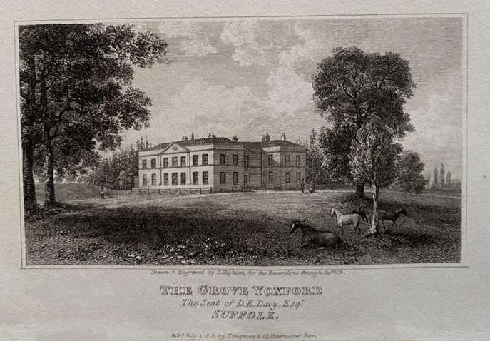
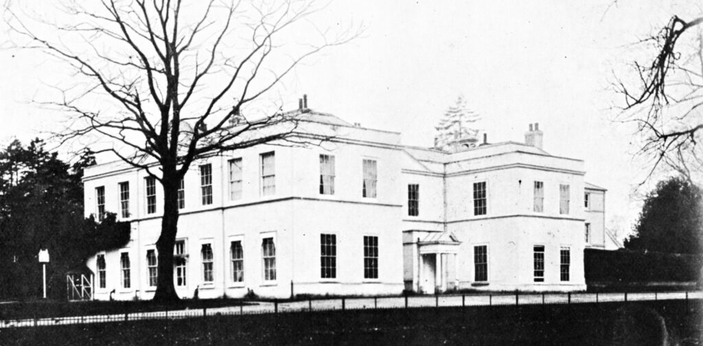
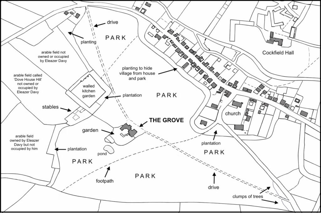
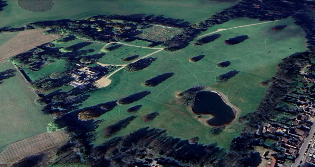
Originally colour-washed, Eleazer Davy’s late-eighteenth century brick house has survived remarkably intact and incorporates the fabric of the earlier sixteenth or seventeenth century predecessor, including the kitchen wing. Now without its colour-wash, it is two storeys high with a seven-bay entrance front with projecting wings facing north-east towards the village. An enclosed porch was added sometime in the nineteenth century. Service wings are to the rear (west) and there is a seven-bay garden elevation facing south-east. It once stood almost centrally within its landscape park, although with the contraction of the size of the park it now lies approximately in the south-west corner.
PARK AND GARDEN
Described by Eric Sandon in his Suffolk Houses. A Study in Domestic Architecture as ‘one of those small classical mansions, set in open parkland in the best traditions of Capability Brown’, the parkland of Grove Park was always compact and its development began soon after Eleazer bought the property, greatly enlarging the park soon after he acquired it. It is shown, but not named, on Hodskinson’s 1783 map, with shelterbelts of trees enclosing a triangular park with ‘Eleazer Davy Esq’ as the owner.
In 1793, when he was staying with his uncle Eleazer, David was in correspondence with the botanist and founder of the Linnean Society James Edward Smith, possibly discussing the design of the landscape and tree planting for the parkland of The Grove. At this time the park extended further to the north-west than shown on the 1840 tithe map. This area of c. 20.5ha (50a) is recorded on the 1839 tithe apportionment as in separate ownership and used for arable. This contraction of the park from the original late-eighteenth century extent was possibly necessitated by the debts Eleazer left when David inherited in 1803. The 1839 tithe apportionment names one of these fields west of the large walled kitchen garden (Grade II) as ‘Dove House Hill’, obviously the site of a dovecote although it does not feature on the tithe map and may have gone by this time.
David is known to have been involved in some of the planting at The Grove in 1784. A few of his plantings are believed to survive as veteran trees today and he may have been responsible for establishing the surviving shelterbelt of trees around the walled kitchen garden and along the north-western park boundary when the park reduced in size.
The square kitchen garden is said to have been built around 1780 by Eleazer. It has red brick walls that were originally c. 3m (10ft) high with a gate along the wall facing the house and further entrance gateways along the other three sides. Thomas Lomax is responsible for raising the height of most of the walls in 1880 to accommodate his grand new surviving lean-to glasshouses along its north-west wall. These were heated and the central section of this wall was raised further to accommodate a higher glasshouse. These glasshouses are included in the Historic England listing for the walled garden.
Beside the kitchen garden were the coach house and stables, described by Sandon as a ‘charming stable building…which echoes the classicism of the house’. During the nineteenth century kennels were added beside the stable block.
There appear to have been few changes made to the park in the middle of the nineteenth century, however the 1885 OS map gives more detail than the earlier tithe map that may not show all features. By 1885 the house is named ‘Grove Park’ and the map shows freestanding trees dotted throughout the parkland, with the walled kitchen garden on the edge of the park. By this time Thomas Lomax’s large range of lean-to glasshouses is shown along the north-west wall of the kitchen garden and the garden had cross- and perimeter-paths. An icehouse that probably dates from c. 1800 is shown within the north-western shelterbelt. Round and built of red brick, it survives today although overgrown and likely to be in a decayed state.
White’s Suffolk directory of 1874 credits Thomas as laying out new gardens. He demolished the old service wings to the rear of the house and added a new white brick range in the Italianate style to create a small courtyard garden. Beyond was a small lawn bounded by a crescent-shaped clump of trees. Taking in part of the parkland, he also extended the area of garden to the south-east of the house, which would allow it to be seen from the south-east drive as it approached the house.
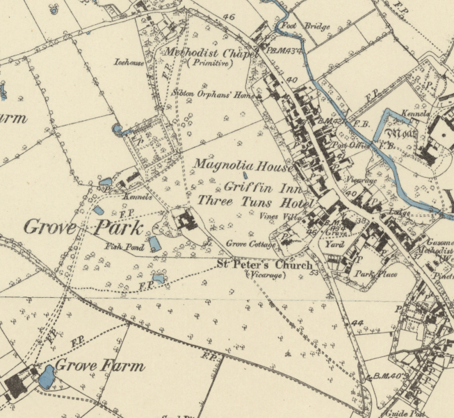
A cricket club was formed in the village at the beginning of the twentieth century with a pitch in Rookery Park on the east side of the village. However, a portion of Grove Park’s parkland near the Church of St Peter (Grade II*) was donated by the Lomax family c. 1933 and a new cricket pitch was created that is still used today by Yoxford Cricket Club. A bowling green was added later in the century.
Once more for sale in 1935 the Grove Park Estate passed through a number of hands until it was bought by Sir Paul Newall and his wife, Lady Penelope, who embarked on a programme of restoration of both the house and grounds. The sales particulars describe a well-wooded park with specimen oaks. The small formal garden to the rear of the house was on sloping ground and approached by steps with a lavender hedge and contained a lily pond and sundial. The kitchen garden was described as well-stocked with wall espaliered and standard apples, pears and other fruits, plus asparagus beds. The heated glasshouses contained vines, peaches and nectarines.
The southern entrance and drive were still in use until the second half of the twentieth century, but were lost when the southern parkland was sold and turned to arable. Following the path first shown on the tithe map, a public footpath now runs from the church along part of the southern boundary between parkland and arable fields.
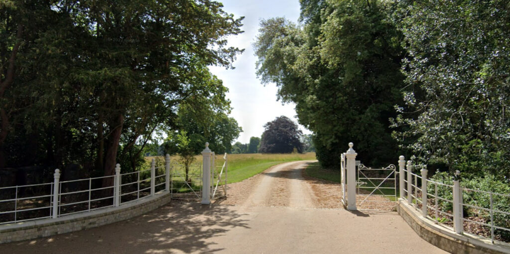
By the time of its sale in 2017 Grove Park had c. 14ha (35a) with mature parkland surrounded by a shelterbelts of trees and some woodland. The walled kitchen garden still had Thomas Lomax’s greenhouses as shown on the 1885 map. The pleasure gardens were mainly west of the house with a raised lawn leading to the pond and wrought iron fencing separating the gardens from the parkland. In 2019 the north entrance gates, piers and flanking walls were replaced by a wider entrance.
More recently a large curved forecourt has been laid beside the entrance front that is surrounded by widely-spaced trees. An irregular lake has been created east of the house and the walled garden is no longer a working kitchen garden but has been laid to beds with sinuous grass paths.
In 2025 Grove Park was assessed by Historic England for registration on the Register of Historic Parks and Gardens but was found not to meet its criteria due to its modest size, layout following the fashion at the time with no associated significant designer/person. Further it has no notable grand entrances, lodges or planned vistas and suffered a number of alterations in the twentieth and twenty-first centuries. The full report can be found at https://www.heritagegateway.org.uk/Gateway/Results_Single.aspx?uid=1494069&resourceID=7
SOURCES:
Blatchy, John, A Journal of Excursions through the County of Suffolk 1823–1844 by David Elisha Davy, ed. Suffolk Records Society, 1982.
Copinger, W. A., The History of the Manors of Suffolk, Vol. 2, 1908.
Denny, Revd A. H., ‘Henry Davy, 1793–1865’ in Suffolk Institute of Archaeology and History, Vol. XXIX, Part 1, 1961.
East Suffolk District Council (previously Suffolk Coastal D. C.) Draft Conservation and Boundary Review, Consultation Document, February 2019.
East Suffolk District Council, Historic Environment Planning Document, June 2021.
East Suffolk District Council (previously Suffolk Coastal D. C.) Supplementary Planning Guidance 6, 1995.
Kelly’s Directory of Suffolk, 1858.
Sandon, Eric, Suffolk Houses A Study of Domestic Architecture, 1977.
Savills’ Sales Particulars, 2016.
White, William, History, Gazetteer & Directory of Suffolk, 1844, 1874.
http://www.suffolklandscape.org.uk/landscapes/Rolling-estate-claylands.aspx org (accessed January 2016).
https://www.wikitree.com/wiki/Warter-Wilson-2 (accessed January 2022).
https://ubbeston.onesuffolk.net/ubbeston-hall/eleazar-davy-of-ubbeston-hall/ (accessed January 2022), with reference to Dr Joanna Martin’s research.
LINNSOC-JES-COR-21-104, the correspondence of James Edward Smith dated 1793 (accessed January 2022).
https://yoxfordparishcouncil.gov.uk/cricket/ (accessed September 2024)
https://www.heritagegateway.org.uk/Gateway/Results_Single.aspx?uid=1494069&resourceID=7 (accessed January 2026)
Census: 1841, 1851, 1861, 1871, 1881, 18191, 1901, 1911.
Maps:
Hodskinson’s Map of Suffolk in 1783.
1839 (surveyed 1840) tithe map and apportionment.
1885 (surveyed 1883) Ordnance Survey map.
1905 (revised 1903) OS map.
Heritage Assets:
Suffolk Historic Environment Record (SHER): YOX 008.
Grove Park (Grade II). Historic England No: 1200613.
Church of St Peter (Grade II*). Historic England No: 1200659.
Walled Garden and Glasshouse to Grove Park (Grade II). Historic England No: 1492992.
Historic England Archive SB00229.
Suffolk Archives (previously Suffolk Record Office):
(SA) HB 26/412/776 & 777. Settlement of marriage between Francis Juliana Warter Wilson, spinster, and Sir John Rous of Darsham Hall, 1788.
(SA) SB00229. The Grove Park Estate, Yoxford and Monk Soham, Suffolk, location maps plus photograph, 31 July 1935.
Site ownership: Private
Study written: February 2026
Type of Study: Desktop
Written by: Tina Ranft
Amended:
