(formerly Sigers or Seagers)
Parish: GRUNDISBURGH
District Council: EAST SUFFOLK (previously Suffolk Coastal)
TM 222 499
Not open to the public
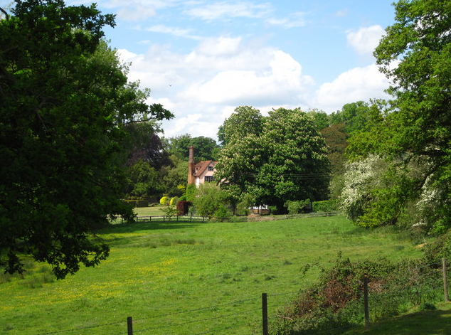
Standing in a c. 34ha (84a) park, Grundisburgh Hall (Grade II) is c. 4.5km (3mls) north-west of Woodbridge and south of the village of Grundisburgh. The Hall is in a small valley running west to east, beside to a stream flowing into a tributary of the River Fynn. The house dates to the early-seventeenth century, but with extensive twentieth century alterations and additions. The seventeenth century part of the house is one range of a much larger sixteenth or seventeenth century building that extended south of the present house, although that part was demolished in the 1960s.
The early modest house was sold to Sir John Wingfield in 1474. By 1553 the estate had expanded to 105ha (260a) of land and in the 1620s the house was altered and extended by William Blois III to create a residence ‘fit for a gentleman’, although by the end of the century the Blois family had moved to Cock Hall in Yoxford. Previously known as Sigers or Seagers, the house changed its name to Grundisburgh Hall c. 1761, but it is not shown with a park on Hodkinson’s map of 1783. The park was probably created c. 1800 by Brampton Gurdon Dillingham Esq., the Gurdon family (Barons Cranworth) owning Grundisburgh Hall into the twentieth century. The tithe map of 1841 shows parkland surrounding the house, which by 1887 had been extended to the south-east and remains intact to the present day. The northern park retains mature free-standing and grouped trees, mainly oak, lime and sweet chestnut and the western and eastern edges are formed by thin tree belts, the eastern mainly of ancient oaks that form the edge to a post 1928 mixed woodland. A winding drive enters through the western belt. The southern park also has numerous free-standing parkland trees with Walnut Hill Plantation on higher land beyond. During the twentieth century water meadows to the south-east of the house were converted into a triangular-shaped lake.
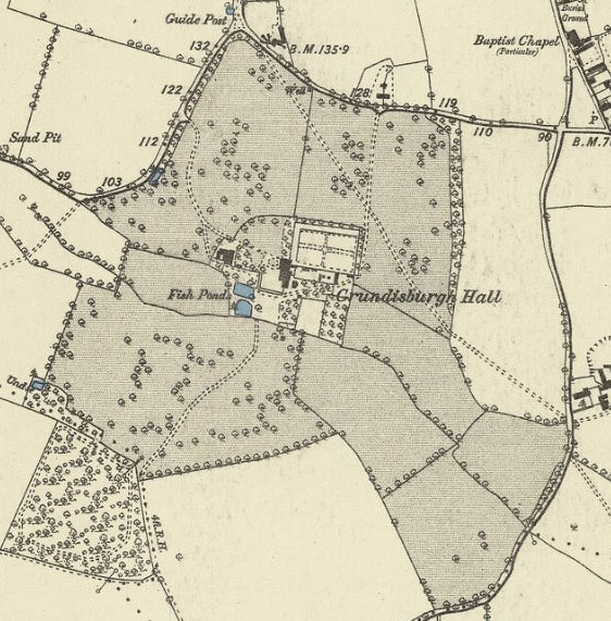
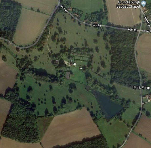
The compact valley site includes a former seventeenth century stable block (Grade II), pleasure grounds and a walled garden that adjoins the house. The rectangular walled garden to the north-east of the house is likely to have been built at the time Grundisburgh Hall was extended in the seventeenth century, although possibly based on the earlier fifteenth century house and surrounding enclosures. Inside it has retained a formal, if simplified, layout of paths with central feature that are shown on the 1887 OS map. A nineteenth century woodland and orchards have been replaced by a lawn, tennis court and grassland south of the house. Two regularly-shaped pre-1842 fishponds to the south-west of the house remain.
SOURCES:
Birch, Mel, Suffolk’s Ancient Sites Historic Places, 2004.
Copinger, W. A., The Manors of Suffolk, Vol. 3, 1909.
Cromwell, Thomas, K., Excursions in the County of Suffolk, Vol. 1, 1818–1819.
Page, Augustine, Topographical and Genealogical, The County of Suffolk, A Supplement to the Suffolk Traveller (of J. Kirby), published in 1847.
Pevsner, N. and Radcliffe E., The Buildings of England: Suffolk, 1974.
Williamson, Tom, Suffolk’s Gardens and Parks, 2000.
East Suffolk Council, Local List of Parks/Gardens of Historic and Landscape Interest, https://www.eastsuffolk.gov.uk/planning/design-conservation-ecology-trees-landscape-and-rights-of-way/conservation/historic-parks-and-gardens/local-list-of-parksgardens-of-historic-and-landscape-interest/ (accessed October 2023)
Hodskinson’s Map of Suffolk in 1783.
1841 (surveyed 1841) tithe map and apportionment.
1887 (surveyed 1881) Ordnance Survey map.
1905 (revised 1902) OS map.
1928 (revised 1925) OS map.
2019 Google aerial map (Imagery © Bluesky, CNES / Airbus, Getmapping plc, Infoterra Lts & Bluesky, Maxar Technologies, Map data © 2019).
Heritage Assets:
Suffolk Historic Environment Record (SHER): GRU 008.
Grundisburgh Hall Park, Supplementary Planning Guidance No 6, 1995, East Suffolk District Council (previously Suffolk Coastal D.C.)
Grundisburgh Hall (Grade II), Historic England No: 1030723.
Stable Block at Grundisburgh Hall (Grade II), Historic England No: 1377203.
Suffolk Record Office (now Suffolk Archives):
SRO (The Hold, Ipswich), 741/HA12/D8/2/4. Draft lease by Brampton Gurdon Dillingham, Grundisburgh Hall, 1779.
SRO (The Hold, Ipswich) HG400/2/282/1. Grundisburgh Hall additions and alterations (1913–1919) for Lord Cranworth.
SRO (The Hold, Ipswich) HD2833/1/SC188. Grundisburgh Hall sales particulars, vendor Lady Cranworth, 1964.
Site ownership: Private
Study written: October 2023
Type of Study: Desktop
Written by: Tina Ranft
Amended:
