Parish: HEMINGSTONE
District Council: MID SUFFOLK
TM 139 537
Not open to the public except on days for charity
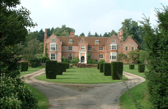
Situated c. 9km (5.5mls) north of Ipswich and c. 1.5km (1ml) and south-east of Coddenham, Hemingstone Hall (Grade I) is an early-seventeenth century house built on the site of a former manor house. It is c. 0.8km (0.5ml) from St Gregory’s Church (Grade I) and the dispersed village of Hemingstone. The attached walled garden on the west side of the house is included in the house listing and probably dates from the eighteenth century, although it includes work from earlier periods. On the site to the north-west of the house is an eighteenth century barn and stabling (Grade II).
Believed to have been built c. 1625 for William Style (d. 1655) – although some references suggest a late-sixteenth century date – the red brick house with Dutch gables on two cross-wings encases a timber-framed house of a similar date. In 1741 a wing was added to the rear and a further cross-wing to the east. In 1758 Hemingstone Hall was inherited by Elizabeth, daughter of the wealthy Nathaniel Acton of Bramford Hall, who was married to Richard Colvile. They appear to have made the Hall their home as their son Robert Colvile, Esq. was born at Hemingstone Hall c. 1763 and was buried in the church in 1799.
By the early-nineteenth century Major William Martin owned Hemingstone Hall and the military tradition continued with his descendants. In the church a plaque to a Lieut. Richard William Colvile Martin (b. 1901) records his accidental death in Germany in 1927, the addition of the name ‘Colvile’ suggesting there was a family connection between the eighteenth century ‘Colviles’ and the nineteenth century ‘Martins’. The family continued to own Hemingstone Hall until 1953. However, there were periods when duties took them abroad and it was rented out, such as to Brigadier Sir James Gault who liaised between Eisenhower and Churchill during World War II. Keen gardeners, James and his wife Elizabeth later bought Hemingstone Hall and in the 1960s and 1970s restored and developed both the house and gardens, as did later owners John and Diana Huntingford from 1993 to 2007, who took over c. 11ha (27a) of gardens and pleasure grounds.
The south-facing Jacobean house lies in a sheltered valley. The land rises sharply behind to the north and more gently on the opposite side of a small country lane running parallel to a tributary of the River Gipping. This is bridged by the entrance drive to the house. A 1749 estate map shows the existing layout of the entrance court with a drive on the central axis of the house, dividing into two before reaching steps up to the porch. A large pond lay near the drive at the entrance from the lane. The central line was continued by an avenue of trees running gently uphill through fields to the south. At the lane end there were two enclosures that may have been nutteries. This avenue appears to have been lost during the nineteenth century, but has more recently been replanted.
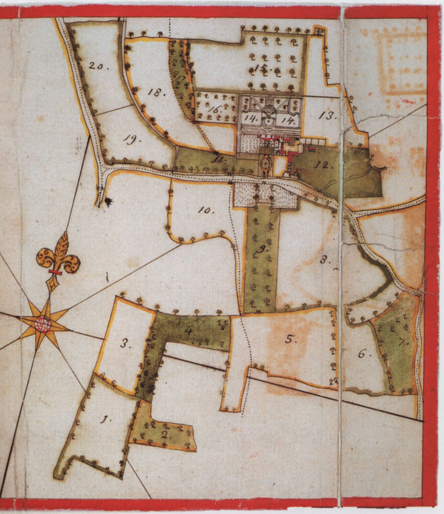
A series of gardens is shown on the eighteenth century map that may have been established c. 1720 or slightly later when the rear and east wings were added in 1741, although the house appears not to have had a surrounding park. Walks and terraces are shown north of the house that were levelled later in the century, with an octagonal amphitheatre-like feature, probably a platform, projecting into the hillside. An enclosure is shown on the site of the present walled garden attached to the western elevation of the house that was dotted with trees, much like an orchard.
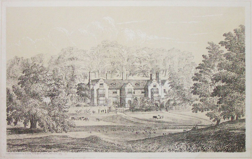
A mid-eighteenth century lithograph of the house by Henry Davy shows that a major part of the previous century’s formal gardens had been swept away, giving views from the lane over parkland grazed by sheep to the house. A small area of shrubbery gave privacy immediately in front of the entrance porch, although the layout of the divided drive had not changed from the previous century.
Today the western enclosure is fully enclosed by c. 3m (10ft) high brick walls of red brick using English garden bonding. It is c. 50m (164ft) x 35m (115ft) and mainly dates to the eighteenth century but incorporates earlier work. Banks running east to west within this walled garden may represent former terraces. It has been suggested that the design of the walled and woodland gardens during the second half of the twentieth century were influenced by American landscape designer Lanning Roper (1912–83), who had many commissions in England during the 1960s to 1980s, including Highgrove for the then Prince Charles. Today the gardens consist of a number of areas, including the woodland garden, eighteenth century pond by the entrance, now covered in waterlilies, a sunken garden with an ornamental pond, parterres and herbaceous borders.
SOURCES:
Battisford & District Gardening Club Newsletter, Issue 42, July 2017.
Birch, Mel, Suffolk’s Ancient Sites Historic Places, 2004.
Debrett’s Baronetage of England, 1815.
Denney, Revd A. H., ‘Henry Davy 1793–1865’ in Suffolk Institute of Archaeology and History, Proceedings Vol. XXIX, Part 1, 1961 (accessed January 2023.
Kelly’s Directory of Suffolk, 1929, 1937.
Miers, Mary, ‘Hemingstone Hall, Suffolk’ in Country Life, 3 May 2007.
Sandon, Eric, Suffolk Houses, A Study of Domestic Architecture, 1977.
Suffolk Gardens Trust Newsletter visit May 2003.
White, William, Directory of Suffolk, 1844.
Williamson, Tom, Suffolk’s Gardens and Parks, 2000.
Census: 1851, 1861, 1871, 1881, 1891, 1901, 1911.
Family tree of Sir Charles Henry Colville http://www.rodono.org.uk/getperson.php?personID=I12009&tree=tree1 (accessed January 2023)
https://landedfamilies.blogspot.com/2015/12/197-asgill-of-asgill-house-richmond.html (accessed January 2023)
Hodskinson’s Map of Suffolk in 1783.
1837 (surveyed 1838) tithe map and apportionment.
1884 (surveyed 1883) Ordnance Survey map.
1905 (revised 1902 to 1903) OS map.
2022 Google aerial map (Imagery © Bluesky, CNES / Airbus, Getmapping plc, Infoterra Lts & Bluesky, Maxar Technologies, Map data © 2022).
Heritage Assets:
Suffolk Historic Environment Record (SHER): HMG 024.
Church of St Gregory (Grade I), Historic England No. 1182641.
Barn, 100 metres north-east of Hemingstone Hall (Grade II), Historic England No. 1033041.
Hemingstone Hall and Attached Garden walls on the South West Side (Grade I), Historic England No: 1182536.
Suffolk Archives (previously Suffolk Record Office):
(SA) HB 8/50/1/62.3. Estate map, 1749.
(SA) HE402/1/1953/6. Catalogue of the Remaining Contents of Helmingham Hall comprising Eighteenth and Nineteenth century Items, 1953.
(SA) HD2833/1/SC203/7. Sale particulars of Hemingstone Hall (Lot 1); barn and paddock (Lot 2), 1991.
Site ownership: Private
Study written: January 2023
Type of Study: Desktop/exterior visit
Written By: Tina Ranft
Amended:
