(also known as Huntingfield Hall Farm)
Parish: HUNTINGFIELD
District Council: EAST SUFFOLK (previously Suffolk Coastal)
TM 342 742
Not open to the public
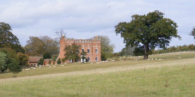
On the site of the original manor house c. 6.5km (4mls) south-west of Halesworth, the present Huntingfield Hall (Grade II*) lies on the south-facing valley side of a tributary of the River Blyth with arable fields to the north, the dispersed settlement of Huntingfield village to the west and south and an area of woodland named Broomgreen Covert to the north-east. The Hall sat in the south-east corner of Huntingfield Park, a well-documented deer park first recorded in 1313 when the manor of Huntingfield was held by the de Huntingfield family. It covered a large area of c. 162ha (400a) bounded by Cookley Green to the west, Cookley village to north, Broom Green to the east, with the river forming the southern boundary. Possible water features have been suggested as being within the park.
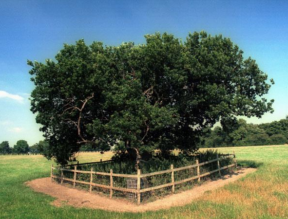
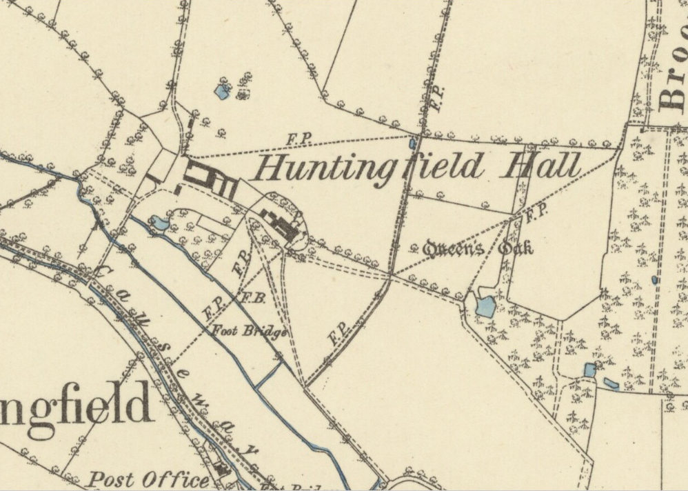
The present house replaced Huntingfield Old Hall, which is depicted on a contemporary drawing as a fortified complex with courtyards and three-storey gatehouse. Queen Elizabeth I is alleged to have stayed at the Old Hall on a visit to her cousin, Lord Hunsdon and in a field to the east of the house stands Queen Elizabeth’s Oak (also referred to as Queen’s Oak and Queen Oak), recorded as being 10m (32.8ft) in circumference in c. 1782, and said to have been used as a vantage point for deer hunting by the Queen. The oak still stands beside a public footpath on the western edge of Broomgreen Covert, although now much reduced in stature and surrounded by metal railings for protection. However, it has been suggested there may be some confusion regarding Queen Elizabeth’s visit in 1578 to her cousin at Melford Hall. Whilst he was the owner of the manor of Huntingfield, Huntingfield Hall is said to have been tenanted by a widow Paston at the time and would not have been suitable for a large royal entourage. Perhaps, it is argued, it was Mary Tudor, widow of King Louis XII of France, Henry VIII’s sister and married to the Charles Brandon, 1st Duke of Suffolk, who visited Huntingfield? Not only did she live at Westhorpe in Suffolk that is c. 40km (25mls) to the west, but is known to have been a lover of hunting and made visits to other parks in the east of the county during her life.
The house was built as a model farmhouse in the late-eighteenth century by Sir Joshua Vanneck, who bought the nearby Heveningham Hall Estate in 1752 and soon after acquired Huntingfield Park, which was then incorporated into the Heveningham parkland. The house is L-shaped with the principle range in the Gothic style, with tall crenellated brick parapet facing south-east and was designed to be seen in the distance from Heveningham Hall (Grade I) to create the illusion of a castle in the landscape, much like other fashionable eighteenth century follies. This elevation was possibly refronted to designs by James Wyatt c. 1780 at the time he was working for Sir Gerald Vanneck on Heveningham Hall.
The tithe map associated with the 1845 tithe apportionment shows a single drive entering the site from the south-west. Here it bridges the tributary of the River Blyth, passing farm buildings before reaching the Hall. By 1884 an additional drive had been added that led directly to the house from the south. It is shown with an avenue of trees on the 1905 OS map. Both drives are still in use today and the south drive continues to be lined with trees as it makes its way through parkland in front of the house. An orchard once lay to the south-west of the house and map evidence suggests there have never been any formal gardens on the site of the farmhouse, just a small area of garden flanked by a line of trees to the rear with parkland surrounding the house. More recently a new plantation has been developed on once arable fields to the north.
SOURCES:
Andrews, Sue and Hoppitt, Rosemary, ‘Helming Leget royal servant and possible designed landscape at Pond Hall, Hadleigh’ in Suffolk Institute of Archaeology and History, Proceedings Vol. XLII Part 3, 2011.
Birch, Mel, Suffolk’s Ancient Sites Historic Places, 2004.
Hoppitt, Rosemary, Deer Parks of Suffolk 1086–1602, 2020.
Griffin, Felicity, ‘Queens Oak, Huntingfield’, 2000, https://www.blythburgh.net/history/oak.php (accessed October 2019)
Sandon, Eric, Suffolk Houses, A Study of Domestic Architecture, 1977.
Scarfe, Norman, editor and translator of François de La Rochefoucauld, A Frenchman’s Year in Suffolk, 1784, 1988.
1736 Kirby’s Map of Suffolk.
1845 tithe map (surveyed 1846) and apportionment.
1884 (surveyed 1882 to 1883) OS map.
1905 (revised 1903) OS map.
1951 (revised 1946) OS map.
2023 Google aerial map (Imagery ©2023 Airbus, CNES/Airbus, Getmapping plc, Infoterra Ltd & Bluesky, Maxar Technologies, Map data @2023).
Heritage Assets:
Suffolk Historic Environment Record (SHER): HFD 010, HFD 029, HFD 042.
Huntingfield Hall (Grade II*), Historic England No: 1183111.
Heveningham Hall (Grade I), Historic England No: 1000494.
Site ownership: Private
Study written: September 2023
Type of Study: Desktop
Written by: Tina Ranft
Amended:
