(demolished c. 1841)
Parish: PLAYFORD (previously a detached part of the parish of Kesgrave)
District Council: EAST SUFFOLK (formerly Suffolk Coastal)
TM 223 474
Not open to the public
Kesgrave House, demolished c. 1841, once stood on the south side of the valley overlooking the River Fynn and a series of ponds known as Playford Mere. The site is c. 4km (2.5mls) south-west of Woodbridge and north-east of Ipswich. On the border between Playford and Little Bealings parishes, the mansion house was originally in a detached portion of the parish of Kesgrave but due to boundary changes it eventually became part of Playford parish, although its stable yard is now in Little Bealings parish.
Hodkinson’s 1783 map depicts a house just south of the river with the name ‘Geo Thomas Esq’ beside it. The river is shown as split at this point creating an island in-between. This house must have been of some status and the river a prominent feature to have been depicted on the map. In 1784 François de La Rochefoucauld in his book A Frenchman’s Year in Suffolk, recalled his journey with Arthur Young and described this area as he travelled from Ipswich to Woodbridge as ‘delightful’ with ‘very pretty houses of the gentry’ with ‘…an enormous farm where a great number of bullocks are fattened. I heard it belonged to a gentleman [authors note: the ‘Geo Thomas Esq’ named on Hodskinson’s map] who lived there and farmed it himself. His estate must be considerable to require such extensive buildings.’
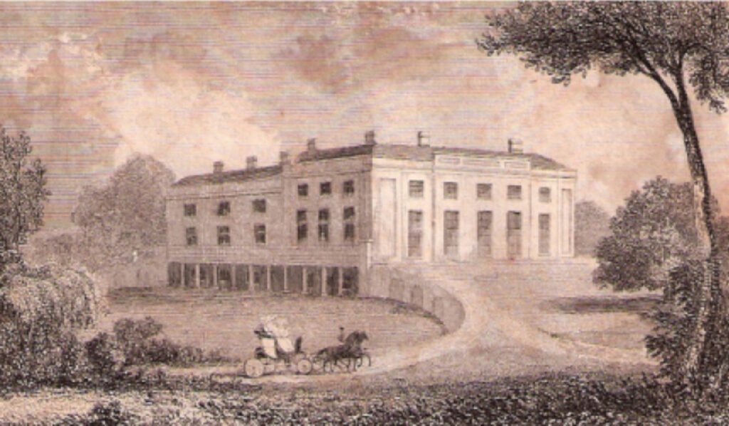
After retiring from active service abroad on health grounds in 1804, Lieutenant-Colonel Thomas Pogson returned to England and in 1806 met and married Emily Myers, cousin to George Thomas. Six years later Thomas Pogson bought George Thomas’s house and land. Norman Scarfe, editor and translator of de La Rochefoucauld’s book suggests the farm may be the later-named ‘Pogson’s’. Soon after Thomas demolished the house and built a new mansion. An undated engraving shows the new mansion perched on the top of a gentle rise with an undercroft cut into a slope. A horse-drawn carriage is shown travelling along a curving drive with another drive forking off this.
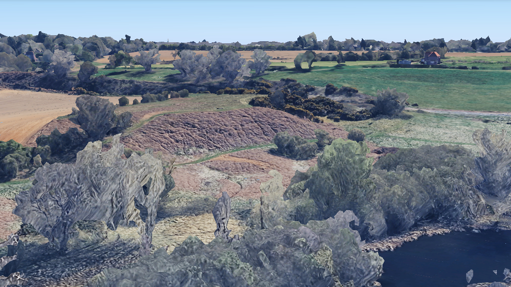
Cropmarks and the contours on historic Ordnance Survey maps of the area show a small escarpment with curved ‘tail’ that correspond to the engraving and would indicate that it depicts the south and west elevations of the house, with the west elevation having the undercroft. This elevation would have given views of Playford Mere and its floodplain. The position of the escarpment and mansion are therefore slightly north of the original house and, presumably, incorporated the site of the farm described by de La Rochefoucauld as the stables and service buildings for the new mansion. Although Thomas and Emily Pogson were involved in local society, he being a patron of Woodbridge Musical Society, they are known to have lived abroad for some time and Kesgrave House was advertised as available to rent in 1833.
After the death of Thomas in 1835 and later his widow, there followed a series of lawsuits regarding the will of Emily Pogson, outstanding debts and the extent of the lands of the Kesgrave House estate. Ultimately in 1841 the house and 33.6ha (83a) of land were sold to Bazett David Colvin Esq, son and heir of James Colvin (d. 1847) of The Grove, a neighbouring property in Little Bealings parish. Almost immediately the thirty-year-old Kesgrave House was demolished. There is no known documentary evidence to explain why, although some three years later the tithe apportionment shows that Bazett still owned the mansion site, but part of the Kesgrave House land was now in the ownership of the Marquis of Bristol, who owned a great deal of land in Playford parish, and parcels of surrounding land were owned by James Colvin. Could this be a consortium of like-minded men looking to future profits? As a merchant trading between London and Calcutta and a founding director of the East Indian Railway, Bazett would have had a particular interest in the first authorisation for a railway linking East Anglia to London in 1836. It seems likely he speculated that this would eventually include a section linking Ipswich to Woodbridge and beyond to Lowestoft, its route following the Fynn valley and thus raising the value of the original Kesgrave House estate land. Ultimately, financial and other issues meant the route between Ipswich and Woodbridge was not finally opened for a further eighteen years in 1859, its route cutting through the Kesgrave House land just south of the mansion site, possibly where the drive with carriage is shown in the engraving.
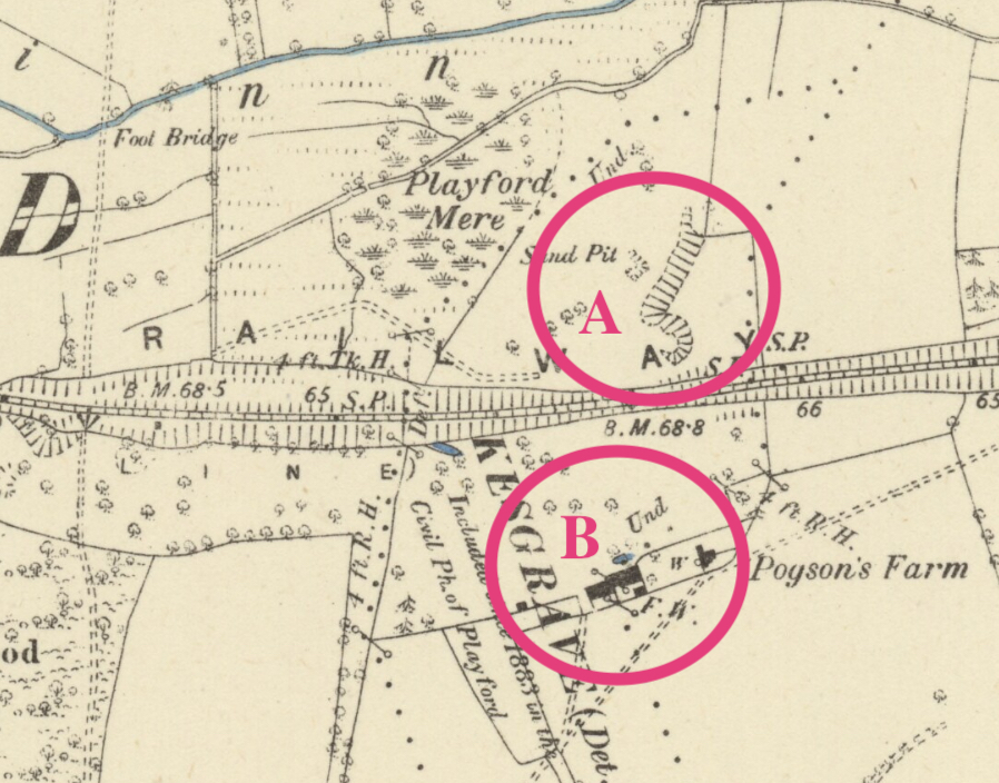
By the time of the 1884 OS map the mansion site was derelict, leaving just an escarpment just north of the railway embankment where the house had been, with a curving end representing the drive up to the house as shown in the engraving of Kesgrave House. Remains of the drive are shown as a track, represented by parallel dotted lines to the west, crossing the edge of Playford Mere. The other south drive, it’s entrance off the Playford Road to the south, had disappeared between the house and its stable and service buildings due to the railway embankment. By this time the buildings were named as ‘Pogson’s Farm’.
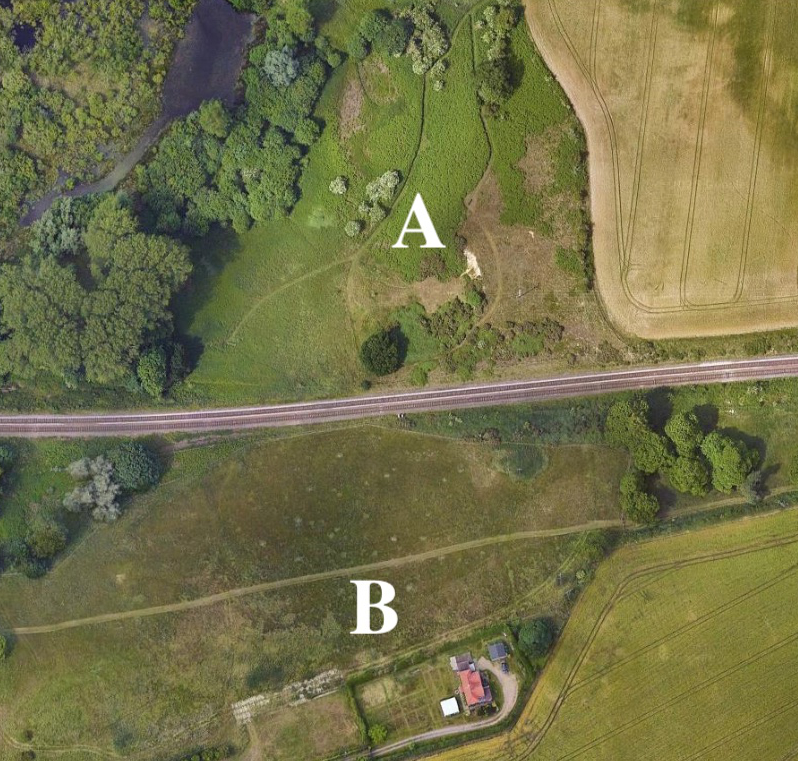
Although in a degraded form, remains of the escarpment survive with a track at its base and Pogson’s Farm is now known as Colonial’s Farm Cottage.
SOURCES:
Bingham, Peregrine, New Cases in the Court of Common Pleas, and Other Courts…, 1841.
Copinger, W. A., The Manors of Suffolk, Vol. 3, 1909.
de La Rochefoucauld, François, A Frenchman’s Year in Suffolk, 1784, p. 132, Edited and translated by Norman Scarfe.
Grace’s Guide to British Industrial History https://www.gracesguide.co.uk/Bazett_David_Colvin (accessed January 2021).
Seward, Brian, ‘Hill House’ from Playford village website http://www.playford.org.uk/Documents/History/HillHouse%20.pdf (accessed January 2021).
The London Gazette, Friday July 8, 1836.
The Suffolk Chronicle; or Weekly General Advertiser & County Express, 30 November 1833.
https://www.wikitree.com/wiki/Pogson-9 (accessed January 2021)
https://www.facebook.com/groups/littleandgreatbealings. Post by Maggie Aggiss (accessed July 2025)
Maps:
1783 Hodskinson’s Map of Suffolk in 1783.
1844 (surveyed 1846) tithe map and apportionments.
1884 (surveyed 1880 to 1881) OS map.
1905 (revised 1902) OS map.
Heritage Assets:
Suffolk Historic Environment Record (SHER): PLY 067.
Suffolk Record Office (now Suffolk Archives):
SRO (Bury St Edmunds) HA 507/2//9/10/6. Deeds of Kesgrave House and 83 acres in Kesgrave, Little Bealings and Playford, 1841.
SRO (Ipswich) HD1678/87. Revd James Ford’s collection of illustrations, nd.
Site ownership: Private
Study written: July 2025
Type of Study: Desktop
Written by: Tina Ranft
Amended:
