(also known as Milding Hall and The Hall, Milden)
Parish: MILDEN
District Council: BABERGH
TL 944 462
Not open to the public except for booked wildlife courses, guided tours, holiday accommodation and events
In an isolated position within the rural parish of Milden, Milden Hall (Grade II*) was originally the manor house for Rashbrooks manor – not to be confused with Wells Hall which was the manor house for Milden manor. On high ground on the Suffolk clayland plateau c. 9.5km (6mls) north-east of Sudbury, it is at the head of a small valley of a tributary of the River Brett, a position it shares with the site of Milden Castle, to the east of the house. This was a minor twelfth century motte and bailey castle that is much degraded due to quarrying and ploughing with little left of the bailey, leaving a large grassed mound.
The Allington family sold it to the Canhams who originally lived at the Hall. In 1690 the will of Robert Canham, gent. states that Milden Hall was a farm and by then the site of the manor of Milden Hall. The Canhams continued to own Milden Hall farm into the eighteenth century. By the time of the tithe apportionment in 1838 the farm was owned by the Revd Henry Powney and leased to farmer Thomas Hawkins, soon after becoming part of the Brent Eleigh Hall Estate when it was bought by Thomas Brown, Esq. of Tostock Place, the farm consisting of 121ha (300a). The Brown family sold their entire estate during the period 1915–22.
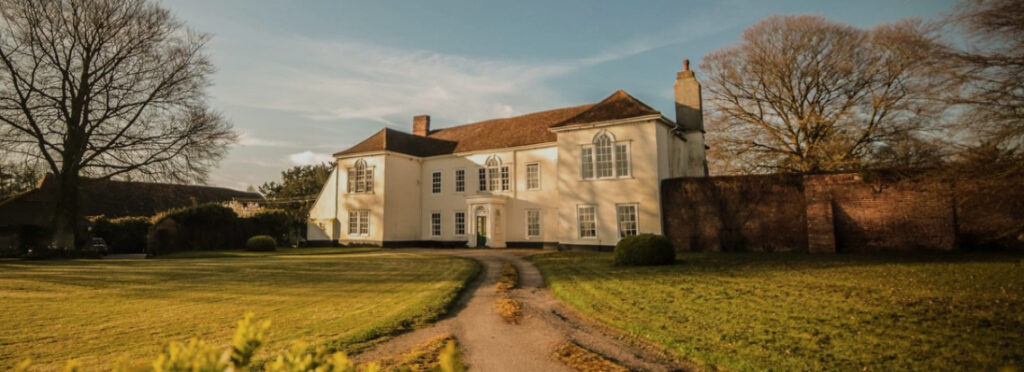
Although the house is listed as a large eighteenth century timber-framed and plastered building, in plan it has been suggested to date to an earlier building of c. 1600. It features two wings to either side of a long two-storeyed central range with entrance facing north and was altered to create a classical looking building in the mid-eighteenth century, said to make this ‘farmhouse look like a small Georgian mansion’. This was perhaps when owned by the Revd Henry Powney and leased to Thomas Hawkins. On the site there are a number of farm buildings including two barns (Grade II) to the south-east of the house, probably dating back to the sixteenth century. One is particularly large with exposed studding, brick noggin and central gabled entrance bay.
Two entrances to the house site are shown on Hodskinson’s 1783 map, their position unaltered in 2022. Now passing between two ponds, the main entrance with a long drive to the north-west is partly flanked by trees with arable fields either side and leading to the front of the house where there is a sweeping in-and-out drive. The other is a farm track leading from Milden village to the east, passing the castle towards numerous old and new farm buildings, before joining the other drive near to the largest barn. In the nineteenth century there were two parkland fields to the north-west and south-west of the house with a surviving brick wall separating the drive from the private western garden.
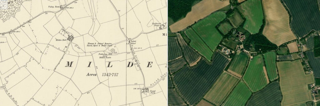
Today it is owned and still farmed by members of the Hawkins family. The 202ha (500a) environmentally farmed land has recently had traditionally coppiced hedgerows and wildflower meadows planted, as well as producing traditional crops such as wheat and winter barley. Gardens have been created around the house, some utilising walls from earlier enclosures, and the parkland has been extended to the north of the house. A wood has been created to the east of the site with a regular pattern of paths radiating out from an area of rough grass. It is surprising how little the field boundaries on the farm have changed since the early-nineteenth century. Diversifying, the Hawkins now run wildlife courses, holidays and accommodation and cater for weddings and events, plus guided tours of the house, garden and barns for private groups.
SOURCES:
Birch, Mel, Suffolk’s Ancient Sites Historic Places, 2004.
Davy, David, Elisha, A Journal of Excursions Through the County of Suffolk, 1823–1844 reproduced by The Suffolk Records Society.
Hawkins, C., Milden Hall, 1990.
Kelly’s Directory of Cambridge, Norfolk and Suffolk, 1922.
Pevsner, N. and Radcliffe E., The Buildings of England: Suffolk, 1974.
Sandon, Eric, Suffolk Houses. A Study of Domestic Architecture, 1977.
Sawday, Alastair, ‘Tudor splendour that knows’ in The Guardian, March 2008.
‘Lindsey Church and Castle’ in Suffolk Institute of Archaeology and History, Proceedings, Vol. XII, Part 2, 1908.
Victoria County History, Suffolk, 1911.
White, William, History, Gazetteer, and Directory of Suffolk, 1844, 1855.
jmc4 – Church Explorer https://www.flickr.com/photos/52219527@N00/14597489110 (accessed April 2022).
Milden Hall website https://www.thehall-milden.co.uk/ (accessed June 2025).
Census 1851, 1861, 1871, 1881, 1891, 1901, 1911.
Hodskinson’s Map of Suffolk in 1783.
1838 tithe map and apportionment.
1885 (surveyed 1885) Ordnance Survey map.
1905 (revised 1902) OS map.
1927 (revised 1924) OS map.
2020 aerial image. Source: Esri, Maxar, Earthstar Geographics, and the GIS User Community
2022 Google aerial map (Imagery © Bluesky, CNES / Airbus, Getmapping plc, Infoterra Lts & Bluesky, Maxar Technologies, Map data © 2022).
Heritage Assets:
Suffolk Historic Environment Record (SHER): MDN 003.
Historic England Research Record, Milden Castle. Hob Uid: 384812.
Milden Hall (Grade II*), Historic England No: 1181918.
Barns to the south-east of Milden Hall (Grade II), Historic England No: 1037113.
Suffolk Record Office (now Suffolk Archives):
SRO (Bury St Edmunds) 1754/3/18. Copy of will of Robert Canham of Milden, 1690 in Brent Eleigh Hall Estate Records.
SRO (Bury St Edmunds) 1754/1/365. Copy of 1690 will proved 1693 in Brent Eleigh Hall Estate Records.
SRO (Bury St Edmunds) 1754/1/366. Copy of charge of John Canham, merchant, of £1,000 on Milden Hall Estate, 1705 in Brent Eleigh Hall Estate Records.
SRO (Bury St Edmunds) 1754/1/367. Sale, owners and tenants, 1722 in Brent Eleigh Hall Estate Records.
SRO (Bury St Edmunds) 1754/1/376. Particulars and conditions, 1873 in Brent Eleigh Hall Estate Records.
Site ownership: Private
Study written: February 2023
Type of Study: Desktop
Written by: Tina Ranft
Amended: June 2025
