(formerly Nettlestead Hall)
Parish: NETTLESTEAD
District Council: MID SUFFOLK
TM 088 492
Not open to the public
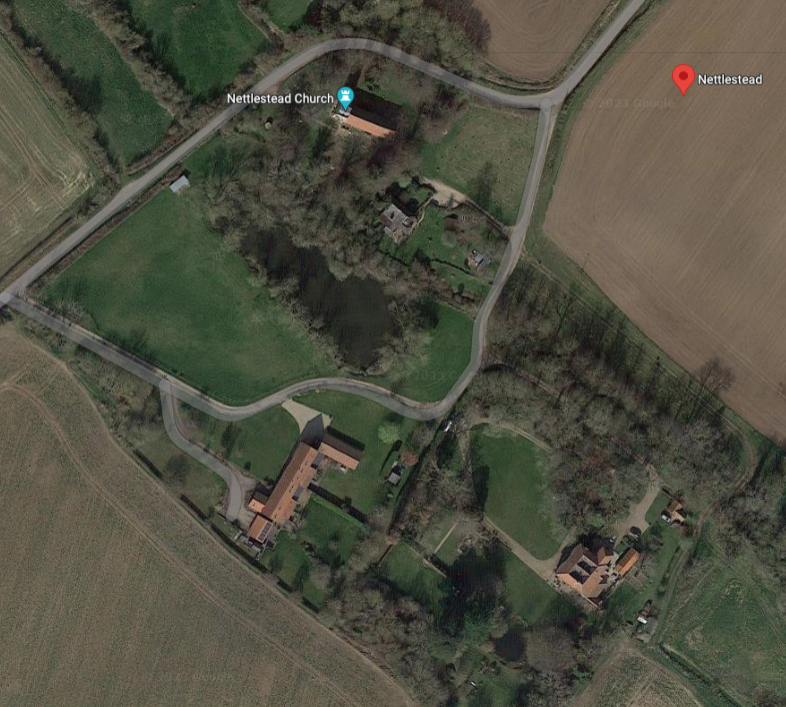
Lying on the Suffolk clayland plateau c. 6.5km (4mls) south of Needham Market and c. 0.8km (0.5ml) north of Somersham village, nineteenth century Nettlestead Chace (Grade II) is on the site of the former manor house of Nettlestead Hall, an important Tudor mansion held by the powerful Wentworth family. In the south of Nettlestead parish with its dispersed settlement, the site is close to St Mary’s Church (Grade I), part of which dates to the twelfth century. A tributary of the River Gipping runs through the site, described in 1823 by David Elisha Davy in his A Journal of Excursions through the County of Suffolk 1823-1844 as a pretty valley in an isolated position. The stream feeds a surviving wide rectangular pond north-west of the house. This was used as a fishpond before its conversion to an ornamental garden feature that was named a ‘canal’ in a late-eighteenth century survey and is marked on the 1905 OS map as having a boat house on its north side.
The Wentworth family sold the estate in 1645 to William Lodge and by 1704 it had passed to John Fuller of Ipswich. By then part of the mansion had already been demolished and the building was said to be large and ruinous. Through marriage it passed to the Bradley family, then the Philipsons until 1813 when it was sold to Lionel Henry Moore, whose father owned Crow’s Hall in Debenham. Lionel undertook substantial renovation and modernisation of the old building to create the present house. In 1839 it was owned by Major Walker with Henry Clark as a tenant farmer who held a substantial holding, This had expanded to 243ha (600a) in 1861 when Edward Snell is registered as the resident farmer, further enlarging to 365ha (900a) and extending southward into Somersham parish by 1881. The Nettlestead Hall Estate including Nettlestead Chace stayed in the Snell family until it was for sale under the direction of the trustees of the will of Edward Snell, Esq, JP in 1911. In 1924 it was home to Mr and Mrs H. G. Rewse-Smith and continues to be a private residence.
A medieval deer park was first recorded at Nettlestead c. 1367. The house is named on Hodskinson’s 1783 map, although a park is not shown, and in 1839 the tithe apportionment for Nettlestead lists a small deer park immediately south-east of the house with field names such as ‘Part of West Park’, ‘Part of Middle Park’ and ‘Part of East Park’ on land just north of the parish boundary with Somersham. The deer park must have originally straddled the parish boundary because the Somersham tithe apportionment also lists field names referencing the park. The 1885 OS map still shows a field with park-like features to the south of the house. Although it is not known when disparkment took place, it seems likely it was before the end of the eighteenth century and possibly much earlier in the seventeenth century and coinciding with the ruinous state of the mansion.
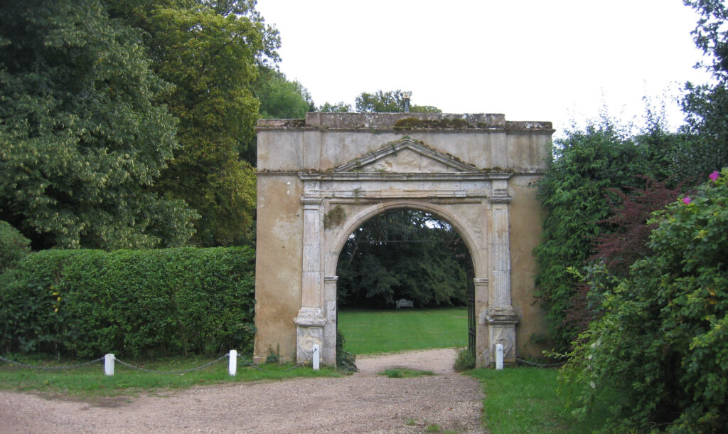
Elements of the earlier hall and cellars are in the present house and a sixteenth century gateway (Grade II) from the Wentworth’s hall survives – a centrally aligned fragment of a wall that once surrounded the base court of the mansion. Much of this wall still survived in 1818 and Henry Davy made an engraving of the grand pedimented gateway in 1824. It is about 5m (17ft) wide and high and was adorned by the Wentworth crest, although it has since become illegible. Next to the gatehouse on the house side there is an octagonal shell summerhouse (Grade II) with a thatched roof that is said to date to c. 1800. It seems likely it could be the work of Lionel Moore sometime after 1813 when he was rebuilding the old house. It has one open side and is constructed in a rustic manner using wattle and daub clad with half logs. The 1839 tithe map shows gardens around the house generally conforming to the footprint of the original outer wall surrounding the Wentworth’s mansion. Within this area the map shows a shelterbelt of trees giving privacy to the house from a surviving track that runs beside the stream to footpaths through meadows. The map also shows a lawn dotted with freestanding trees and two small regular enclosures marked as ‘Gardens’. On the 1885 OS map the more southerly is shown to have been walled. Aerial photographs suggest this has partially survived into the twenty-first century and the gardens remain much as they were in the nineteenth century.
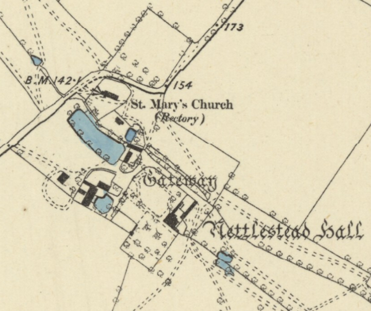
The 1837 OS map marks a parsonage and cottages between the church and the Hall. The parsonage ceased to be used by the church and became a private residence with large garden beside the stream and the cottages are believed to have abandoned during the latter part of the twentieth century, possibly after suffering bomb damage in World War II. As with other manor house sites, Nettlestead Hall would have had a large tithe barn. The present residential barn conversion appears to lie on the footprint of such a barn just north-west of the house, having been part of a courtyard of farm buildings associated with the farmhouse of Nettlestead Chace. Nearby there was a large dovecote that was said to date to the sixteenth century. A photograph taken in 1912 by Revd Edmund Farrer shows a rectangular structure with a pyramidal roof that was later converted to a grain silo and finally demolished in 1966.
SOURCES:
Barker, H. R., West Suffolk Illustrated, 1907.
Birch, Mel, Suffolk’s Ancient Sites Historic Places, 2004.
Copinger, W. A., The Manors of Suffolk: The Hundreds of Blything and Bosmere and Claydon, Vol. 2, 1908.
Cromwell, Thomas, K., Excursions in the County of Suffolk, Vol. 1, 1818–19.
Davy, David, Elisha, A Journal of Excursions through the County of Suffolk 1823-1844, published by Suffolk Records Society, 1982.
Hoppitt, Rosemary, Deer Parks of Suffolk 1086–1602, 2020.
Martin, Edward, ‘Garden Canals in Suffolk’ in East Anglia’s History, Studies in Honour of Norman Scarfe, 2002.
Page, Augustus, Supplement to the Suffolk Traveller [of J. Kirby] or Topographical and Genealogical Collections, Concerning That County, 1844.
Sandon, Eric, Suffolk Houses, A Study of Domestic Architecture, 1977.
Suffolk County Council Archaeological Service, Archaeological Watching Brief Report, 2009.
Suffolk Institute of Archaeology and History, Excursions, Vol. XVII, Part 3, 1924.
Facebook post from January 2020 with photograph of cottages with bomb damage courtesy of Julie Rex https://www.facebook.com/groups/174852349937156/posts/612083619547358/ (accessed September 2023)
Census: 1841, 1851, 1861, 1871, 1881, 1891, 1901, 1911.
Hodskinson’s Map of Suffolk in 1783.
1839 (undated survey) tithe map and apportionment.
1885 (surveyed 1881 to 1884) Ordnance Survey map.
1905 (revised 1902) OS map.
2023 Google aerial map (Imagery © Bluesky, CNES / Airbus, Getmapping plc, Infoterra Lts & Bluesky, Maxar Technologies, Map data © 2023).
Heritage Assets:
Suffolk Historic Environment Record (SHER): NTT 002, NTT 005, NTT 006, NTT 015, NTT 028, NTT MISC.
Nettlestead Chace (Grade II), Historic England No: 1251559.
Gateway, 60 metres north-west of Nettlestead Chace (Grade II), Historic England No: 1250946.
Shell Summerhouse, 70 metres north-west of Nettlestead Chace (Grade II), Historic England No: 1262717.
Church of St Mary (Grade I), Historic England No: 1263028.
Suffolk Record Office (now Suffolk Archives):
SRO (Ipswich), HE402/1/1911/48, Sale particulars for the Nettlestead Hall Estate, 18 July 1911.
SRO (Ipswich), HD78:2671, the Edward Farrer archive, Nettlestead.
Site ownership: Private
Study written: September 2023
Type of Study: Desktop
Written by: Tina Ranft
Amended:
