Parish: POSLINGFORD
District Council: WEST SUFFOLK (previously St Edmundsbury)
TM 778 481
Not open to the public
New House Farm (Grade II) is c. 4km (2.5mls) north-east of Clare and c. 16km (10mls) north-west of Sudbury in an isolated position east of the village of Poslingford with far-reaching southerly views over an undulating clay landscape towards the River Stour valley to the south.
Acquired by Golding family in 1540, New House is thought to have replaced an earlier manor house and a reference to a ‘Newhouse’ is documented in 1572. The Goldings were a principle family in the area and made New House their home, suggesting a house of some status. Hodskinson’s 1783 map of Suffolk shows a small park with the house at the head of a wooded valley with stream flowing south-east to join a tributary of the River Stour and a short avenue from the house running south-westward towards the church and village, although by the time of the tithe map of 1841 this had gone.
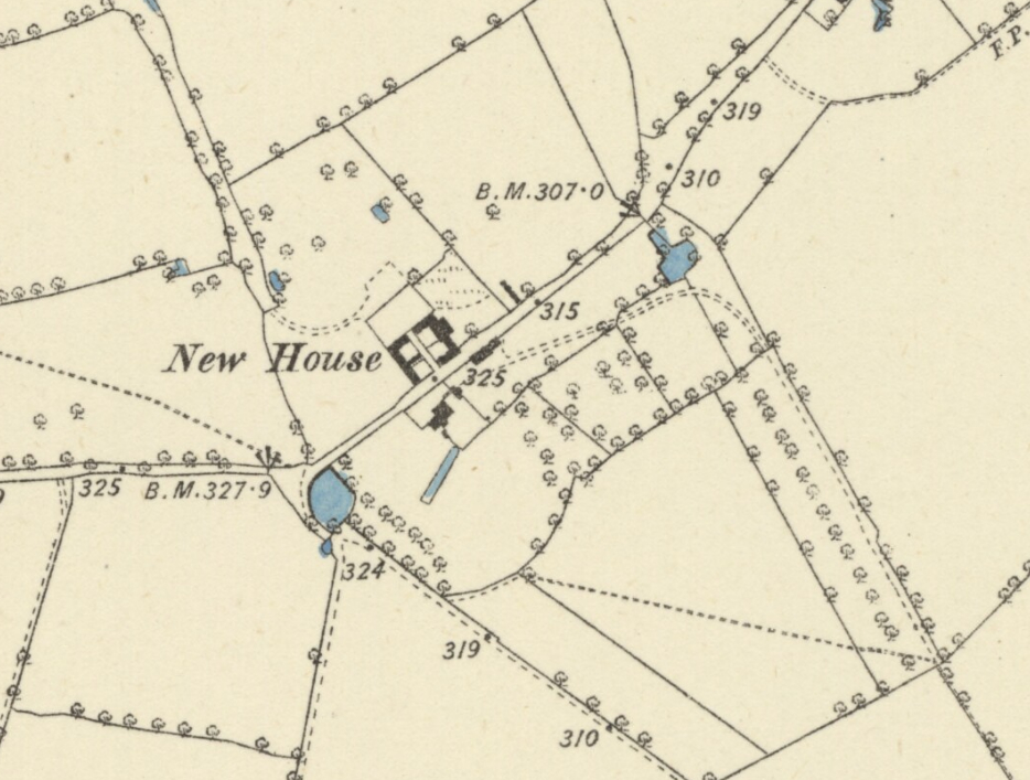
An estate map of 1806 gives a more detailed picture of the site with a canal-like pond c. 47m (154ft) x 6m (20ft) parallel to the front of the house but slightly off-set. At its north end it is attached to a garden to the rear of the house with a cruciform layout of paths, probably a formal ornamental or kitchen garden. Along the rear boundary of this garden, a walkway led to the north end of the canal, where the tithe map of 1841 shows a small square building, probably a summerhouse, although it is not shown on the 1885 OS map. It is thought that the builder of the canal was probably George Golding (c. 1687–1739) who inherited the estate in 1702. However, by the time of the 1806 map the family appear to have left New House after George Golding, Esq. (c. 1724–1803) moved to Thorington Hall in East Suffolk on his marriage in 1762 to Ann Bence, daughter and heiress of Alexander Bence. It seems likely it was at this time that New House became a tenanted farm, which is later documented as leased to the Hunt family in 1793. Census returns from 1841 to 1881 give the Ambrose family as resident farmers having built up a sizeable holding of c. 222 ha (550a) and at the beginning of the twentieth century the Tuffin family had taken over the farm.
Stabling lay north-east of the house, with farm buildings on the opposite side of the lane to the village. The tithe map shows this as two barns with an L-shaped pond attached to the largest. These had been swept away by 1885 to be replaced by a courtyard of buildings much like a model farm. A small square structure, probably a dovecote, at the edge of these is first shown in 1806 but had gone by 1885. A further possible dovecote west of the house gardens is recorded in an area once called Dovehouse Field.
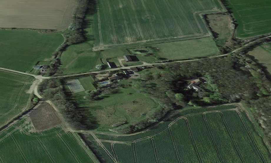
In 2022 the Golding’s house is much-diminished in size. L-shaped, it has elements dating back to the seventeenth century, although substantially altered in the eighteenth century. The stabling, which may be late-eighteenth or early-nineteenth century, is in various states of decay. The southern boundary of a small area of the parkland south of the house, first shown on the tithe map as a semi-circular feature, can be seen on LiDAR images as a ditched ha-ha with an agricultural field beyond. Shelterbelts of trees surround the small park-like area to the east, south and west. The canal survives as a pond surrounded by overgrown trees, but not the walkway. The courtyard of farm buildings has gone, leaving one small barn and remnants of low mid-nineteenth century enclosure walls.
SOURCES:
Birch, Mel, Suffolk’s Ancient Sites Historic Places, 2004.
Kelly’s Directory of Suffolk, 1922.
Martin, Edward, ‘Garden Canals in Suffolk’ in East Anglia’s History, Studies in Honour of Norman Scarfe, 2002.
Page, Augustine, Topographical and Genealogical, The County of Suffolk, A Supplement to the Suffolk Traveller (of J. Kirby), compiled 1811 and published in 1844 by Page, Joshua.
Roberts, W. M., Lost Country Houses of Suffolk, 2010.
The London Gazette, 29 January 1765. Reference regarding George Golding of Thorington Hall, High Sheriff of Suffolk.
Census: 1841, 1851, 1861, 1871, 1881, 1901, 1911.
Hodskinson’s Map of Suffolk in 1783.
1840 (tithe map 1841) and apportionment.
1885 (surveyed 1884) Ordnance Survey map.
1905 (revised 1902) OS map.
2020 aerial image. Source: Esri, Maxar, Earthstar Geographics, and the GIS User Community
2022 Google aerial map (Imagery © Bluesky, CNES / Airbus, Getmapping plc, Infoterra Lts & Bluesky, Maxar Technologies, Map data © 2022).
2022 Google Earth.
2022 Google Street View.
Heritage Assets:
Suffolk Historic Environment Record (SHER): PSG 005, PSG 007, PSG 008, PSG 009, PSG 018.
New House Farmhouse (Grade II). Historic England No: 1227468.
Suffolk Record Office:
SRO (Bury St Edmunds) HD 1778. Estates of Golding and Weston Families,
SRO (Bury St Edmunds) HD 1778/1/2. Lease from George Golding of Poslingford to Frances Hunt, widow, and James Hunt, farmers of the same, 1793.
SRO (Bury St Edmunds) HD 1778/7/3. Marriage settlement of Sir John Rous, Bt, of Darsham Hall to Frances Juliana Warter of The Grove, Yoxford. George Golding Esq. of Thorington Hall a trustee, 1788.
SRO (Bury St Edmunds) 537, information in Martin, Edward, ‘Garden Canals in Suffolk’ in East Anglia’s History: Studies in Honour of Norman Scarfe, 2002.
SRO (Bury St Edmunds) HA537, Title Deeds and Papers of the Golding and Weston families 1302–1862, in Martin, Edward, information in East Anglia’s History: Studies in Honour of Norman Scarfe, 2002.
Site ownership: Private
Study written: December 2022
Type of Study: Desktop
Written by: Tina Ranft
Amended:
