Parish: NORTH COVE
District Council: EAST SUFFOLK (previously Waveney)
TM 464 894
Not open to the public
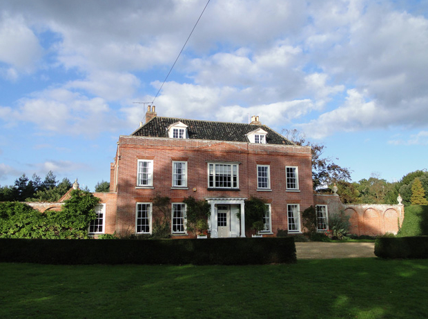
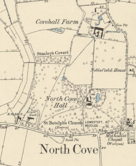
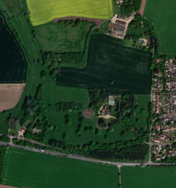
Just south of the Waveney River, the boundary between Suffolk and Norfolk, Georgian North Cove Hall (Grade II*) sits at c. 10m (33ft) above sea level in a valley-side location c. 5.5km (3.5mls) east of Beecles. The Hall is west of North Cove village and north-east of its medieval, thatched Church of St Botolph (Grade I), which lies just outside North Cove Hall’s small early-nineteenth century park. The closeness of the church to the house suggests it was the site of an ancient manorial hall, known as a ‘hall-and-church’ cluster. A ha-ha separates the pleasure gardens from parkland to the south and a walled garden lies to the rear of the house.
OWNERS OF NORTH COVE HALL
John Smith Esq. owned North Cove Hall in the 1740s. His daughter Sarah married John Morse of Hickling in Norfolk. The Morse family had been considerable landowners in Suffolk in the middle of the seventeenth century with properties in Wangford, Glemham and Stratford, all straddling the main trunk road between Ipswich and Lowestoft, now the A12. John Morse’s father was a merchant and shipowner from Hickling and Great Yarmouth. By 1783 the Hall was owned by John Farr (1723–95) and passed to his son, also John (1757–1824). In 1844 it was described as ‘an ancient mansion, with pleasant grounds’ the property of John Cooper, Esq. who owned much of the parish. After John’s death it was sold in 1846 to William Everitt, Esq., son of George Everitt of Caister Castle. From about 1879, after the death of William, it was inherited by his son William Spencer Everitt (d. 1913) and appears to have had a series of tenants whilst William Spencer lived with his family at Broad House in Oulton Broad – Broad House and grounds later donated to the local community to become Nicholas Everitt Park. North Cove Hall was sold to Frederick W. Smalley, Esq. in 1917 and two years later to Capt. Edward Fortrey George Turnball Heap. In 1926 it was bought by the Blower family. It is unclear how long they stayed at North Cove, although it was once more for sale in 2008.
THE HALL
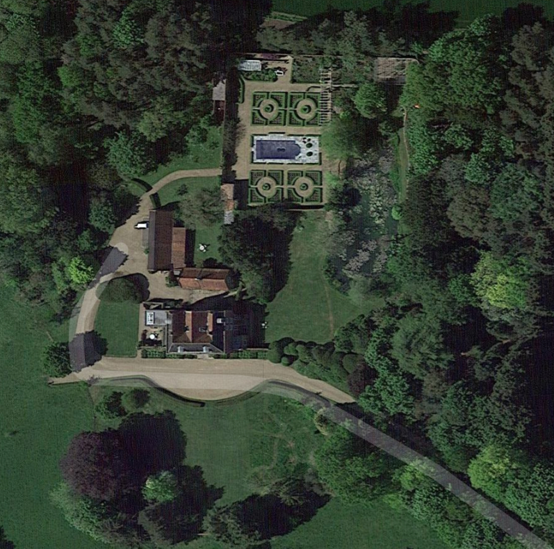
Built of red brick, North Cove Hall has two storeys plus attic and dates to c. 1760–70 when the existing house was being extensively altered and enlarged by John Farr, leaving just the rear wing which probably dates to the previous century. This small country house has typical Georgian proportions, parapet, sash windows and Roman Doric porch on square columns. At each end of the front range single storey wings with flanking triple-arched screen walls surmounted by vases were added later and are shown on the 1848 tithe map. To the north of the Hall is the stable block and coach house courtyard open on its north side.
THE PARK AND PLEASURE GROUNDS
The house is named on Hodskinson’s 1783 map, although no park is shown on this or other eighteenth century maps. North Cove Green was shown immediately to its north. The landscape park is believed to date from the early-nineteenth century and a park covering c. 20ha (49a) appears on a draft OS drawing dated c. 1815, which would make it the work of the Farr family. In 1828 a highways diversion may have allowed the green to be incorporated into the estate to become the home farm as it is described in the tithe apportionment of 1848. By this time parkland surrounded the house to the east, south and west, with a large field to the north named ‘Chesnut and Barn-Meadow’.
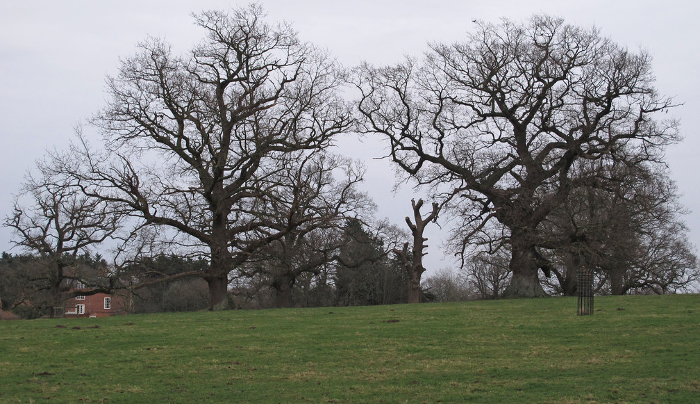
This landscape park incorporated some areas of ancient woodland with shelterbelts of trees to the southern boundary that were probably newly-created after the establishment of the park. The tithe map shows an area was left clear of trees in the centre of this shelterbelt and thus allowing views of the south front of the house from the road running from Lowestoft through North Cove village to Worlingham. At the time of the tithe map there were two main entrances, both along the southern boundary. One was beside the church, the other closer to North Cove village with the in-and-out drive curving through the park to the entrance forecourt. North-west of the house there was an elongated plantation with a central pond and another at its far western end. Beside this plantation was an orchard. Giving privacy from the village, a further shelterbelt ran along the road travelling north to the farm and River Waveney beyond. This had a subsidiary entrance with track leading to the rear of the square walled garden and pleasure grounds. The walled garden had curved corners with an oval pond that unusually straddled the southern wall to be partly in and partly outside the garden. Inside the garden, two small buildings, possibly summerhouses, sat either side of the pond, with a freestanding building, likely to have been an orangery, in its western half. Pleasure gardens curved around the walled garden joining a semi-circular garden in front of the house that was bounded by a ha-ha. The tithe map suggests there was a further ha-ha curving around the pleasure gardens to the east of the house.
In 1874 William White described North Cove Hall as having a ‘beautiful lawn [parkland] and pleasure grounds, extending to 70 acres [28ha]’. These are shown ten years later on the more detailed 1884 OS map when the parkland had a number of freestanding trees, mostly deciduous, scattered individually and in small clumps throughout the parkland to east, south and west of the Hall. The meadow to the north was less densely treed and the elongated plantation to the north-west of the house had reduced in size with its western portion having fewer trees than earlier in the century. The same thinning out of trees had also taken place along the southern shelterbelt.
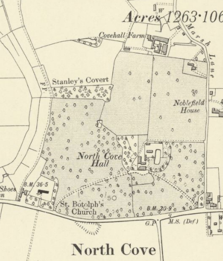
North Cove Hall Estate was described in sales particulars of the 1920s as a ‘residential, agricultural and sporting estate’. A new section of the A146 trunk road between Beecles and Lowestoft was built in the second half of the twentieth century that ran south of the park’s southern boundary and bypassed the village. The narrow strip of land between the old and new roads has subsequently been planted with trees and incorporated into the park, the south-western entrance beside the church and drive have been lost and the old road has become a footpath. The meadow to the north of the house was converted to arable during the twentieth century, but the main areas of ornamental parkland have remained relatively unaltered to the present day, retaining areas of ancient woodland with scattered plantings of trees and shelterbelts to the east, south and west of the garden site that are documented covering c. 8.6ha (21.2a) in 2008.
In the gardens around the house the pond survives straddling the south wall of the walled garden, which is now divided into three main sections. In the western half of the walled garden, box-lined paths form a formal, geometric pattern in two sections either side of a swimming pool. This was built on the site of a freestanding glasshouse shown on the tithe map. The nineteenth century ha-ha separating the gardens from parkland survives to the south of the house and may also continue around the eastern pleasure gardens, although today this is obscured by a number of mature trees and shrubs.
SOURCES:
Birch, Mel, Suffolk’s Ancient Sites Historic Places, 2004.
Burke, Sir Bernard, A Genealogical and Heraldic History of the Landed Gentry of Great Britain and Ireland, Vol II, 1871.
Kelly’s Directory of Suffolk, 1922.
Place Services, East Suffolk Historic Parks and Gardens, East Suffolk D. C., 2021. Review and assessment of five Historic Parks and Gardens within the former Waveney area identified to bring them into the new East Suffolk District Local List of Non-designated heritage assets under Policy SCLP11.8: Parks and Gardens of Historic or Landscape Interest.
Suckling, A., A History & Antiquities of Suffolk, Vol. I, 1846.
White, William, History, Gazetteer, and Directory of Suffolk, 1844, 1874.
Williamson, Tom, Suffolk’s Gardens and Parks, 2000.
Suffolk Landscape Character Assessment https://suffolklandscape.org.uk/glossary/hall-and-church (accessed April 2022).
Census: 1851, 1861, 1901, 1911.
Hodskinson’s Map of Suffolk in 1783.
1838 tithe map and apportionment.
1884 (surveyed 1883) Ordnance Survey map.
1906 (revised 1903) OS map.
1933 (revised 1926) OS map.
1947 (revised 1938) OS map.
1951 (revised 1947) OS map.
2020 aerial image. Source: Esri, Maxar, Earthstar Geographics, and the GIS User Community
2022 Google aerial map (Imagery © Bluesky, CNES / Airbus, Getmapping plc, Infoterra Lts & Bluesky, Maxar Technologies, Map data © 2022).
Heritage Assets:
Suffolk Historic Environment Record (SHER): NHC 009, NHC 010 and NHC 028.
North Cove Hall (Grade II*), Historic England No: 11872794.
Church of St Botolph, Lowestoft Road (Grade I), Historic England No: 1032041.
Suffolk Record Office (now Suffolk Archives):
SRO (Lowestoft) 849. Evidences of title to North Cove Hall Estate, 1792–1919.
SRO (The Hold, Ipswich) 849/1. Evidences of title to North Cove Hall estate of 505a, 1792–1919.
SRO (Ipswich) A276/217. Highway Diversion Order for North Cove, 1828.
SRO (Ipswich) 1117/303/4. Sales particulars for the surplus furniture and household effects of North Cove Hall and Cove Hall Farmhouse, 23 Sep 1969.
SRO (Lowestoft) 1117/303/11. Sales Particulars, 2008.
Site ownership: Private
Study written: February 2023
Type of Study: Desktop
Written by: Tina Ranft
Amended:
