(Hall demolished in 1955 now Ousden House, a remodelling of the stable block)
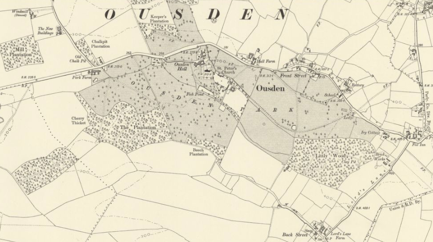
Parish: OUSDEN
District Council: WEST SUFFOLK (previously St Edmundsbury)
TL 735 596
Not open to the public
Close to the county boundary with Cambridgeshire c. 11km (7mls) south-east of Newmarket and 13km (8mls) south-west of Bury St Edmunds, Ousden lies in an area of undulating, free-draining chalky bounder clay and is believed to be the highest village in East Anglia. The former site of Ousden Hall, which was demolished in 1955, lies beside the twelfth century Church of St Peter (Grade I) and remote from Ousden village, which lies to the east. The site is south-sloping and overlooks a tributary of the River Kennett. The gardens of the former Hall, including a canal that developed from the remaining arm of a former moat and raised walkway, are now part of the gardens of Ousden House, which is a remodelling and extension of the original late-eighteenth century stable block (Grade II). The site also contains a mid-nineteenth century clock tower (Grade II) and eighteenth century dovecote (Grade II), both associated with Ousden Hall. It is surrounded by a designed parkland landscape that originally developed from wood pasture and ancient woodland.
OWNERS OF THE OUSDEN HALL ESTATE
The Ousden Hall Estate passed from the Waldegrave to the Moseley family in 1567. They remained there until 1800 when the Smith family briefly acquired it, passing it to the Revd James Thomas Hand in 1805. At his death in 1835 it was inherited by his nephew Thomas James Ireland Esq., High Sheriff of Suffolk, who died in 1863. The estate was bought by Bulkley John Macleod-Praed (d. 1905), who was from a wealthy banking family with links to Lloyds. His son, Sir Hubert, became MP for Ipswich. The family appear not to have lived at Ousden and the house was let, primarily for the shooting. In 1913 Sir Hubert’s youngest half-brother, Algeron Macleod-Praed bought the estate. Algeron lived at the Hall until the beginning of World War II when it was requisitioned and used by the Army and then as a prisoner of war camp. In 1954, after the death of Algeron, the estate of 1,049ha (2,593a) was sold to the Shelley-Rolls family. At the time the Hall was said to be too expensive to restore and was demolished in 1955 when the estate was broken up. Its successor, Ousden House, was created from the late-eighteenth century stable block in the 1970s after it was bought by Alasdair and Lavinia Robinson who began to develop the today’s gardens.
THE HALL
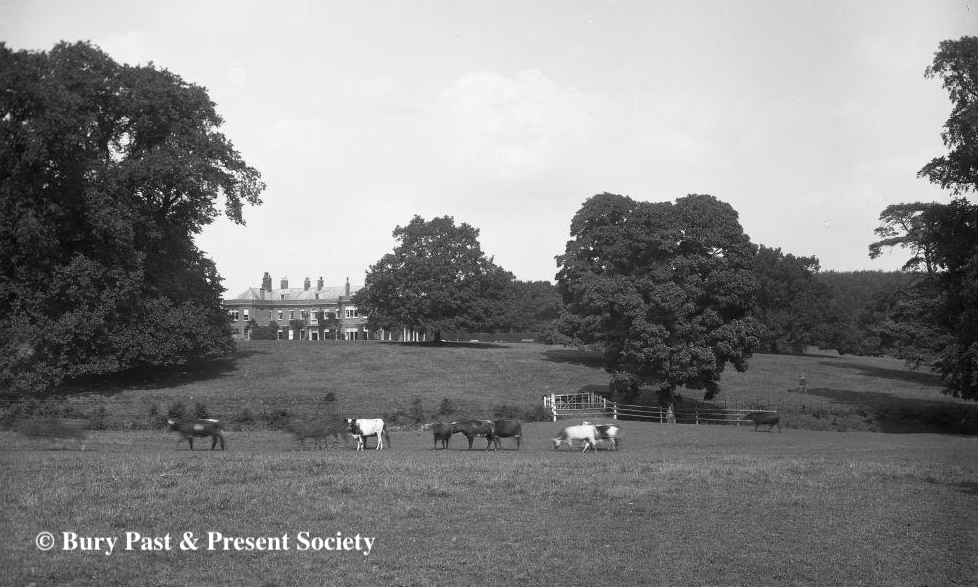
Surrounded by a moat, Ousden Hall was erected in the time of Queen Elizabeth I for the Moseley family who rebuilt it in the mid-eighteenth century to create a large U-shaped building with projecting wings at the rear, possibly leaving just the porch from the earlier house standing. The house was enlarged and remodelled c. 1820 and described in 1827 as being on ‘rising ground, and commands several pleasing views over the vicinity and adjoining county of Cambridgeshire.’ In 1835/6 Thomas Ireland engaged the architect Thomas Rickman to make further alterations in the ‘Grecian style’ to give a house with a north-facing entrance front, west elevation looking over the parkland and south-facing garden front, described in White’s 1855 Directory of Suffolk as ‘a handsome mansion, with pleasant grounds’. It was reported that Thomas Ireland entertained King William IV when he attended the races at Newmarket.
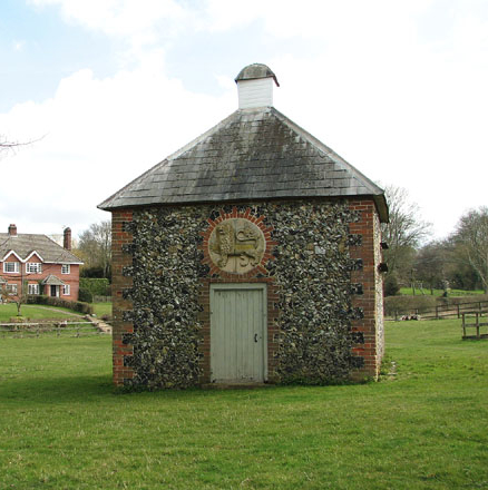
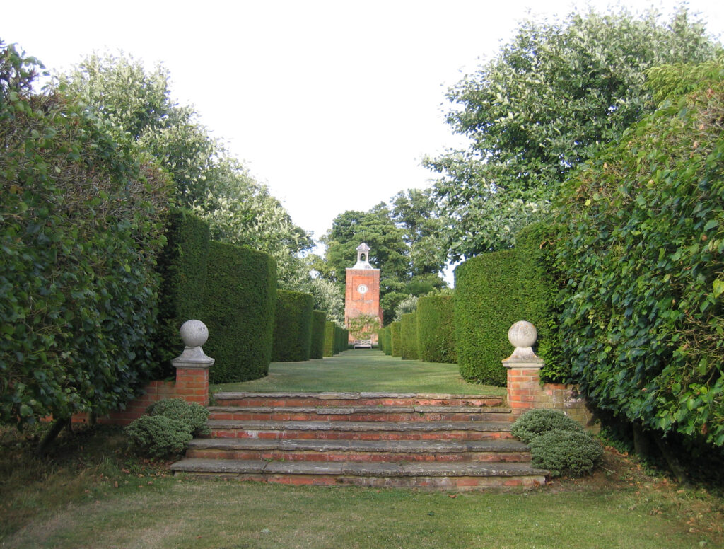
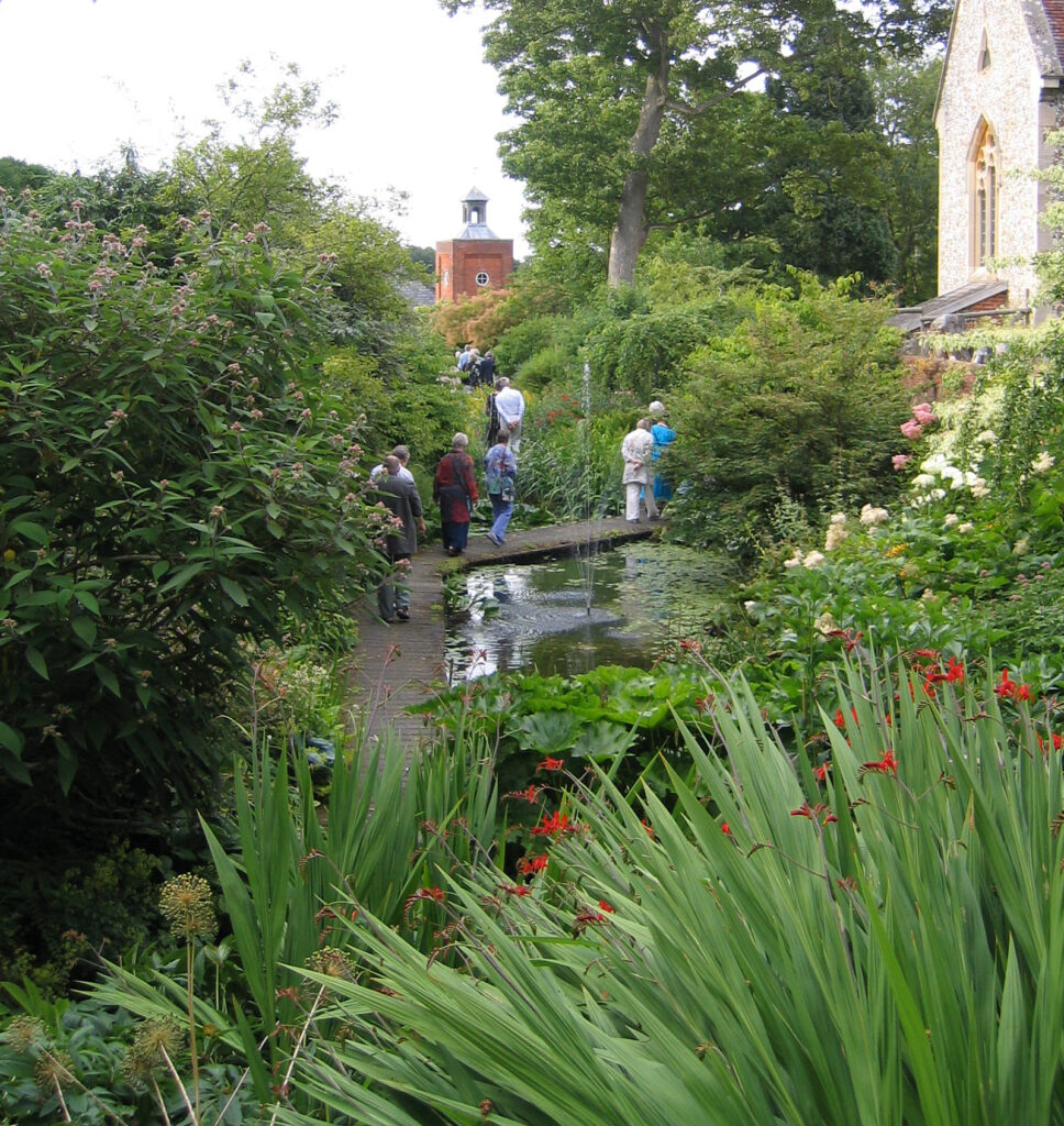
Few further changes were made to the house during the following years until Algeron Macleod-Praed bought the estate in 1913. In addition to adding towers to both ends of the house and making alterations to the porch and internal layout, Algeron updated the services in the house to make it fit to be his home. During World War II the house and grounds were requisitioned by the Army and later used to house prisoners of war. A watercolour of Ousden’s walled garden painted by a prisoner was in the possession of the owner of Gardener’s Cottage and walled garden in 2016. Like many country houses in Suffolk, the war had taken its toll on the house and following Algeron’s death in 1952 it was said to be beyond economic repair and demolished in 1955. This left a mid-nineteenth century eastern clock tower from the old house still standing, which today acts as a focal point within the pleasure gardens of Ousden House.
THE PARK
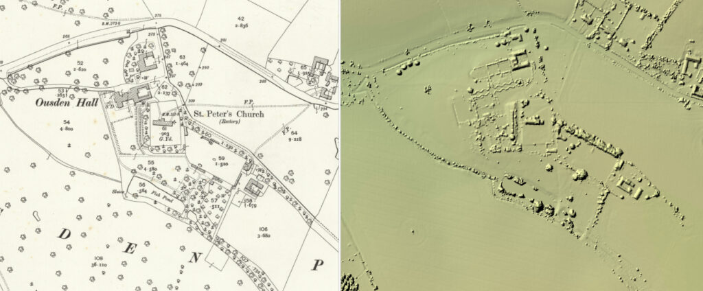
The Moseley family’s Elizabethan house stood in a park that is believed to have developed from ancient woodland and wood pasture. Although there were a number of medieval deer parks in the surrounding area there is no known record of one at Ousden. The de Clare family’s main Suffolk park was at Hunsdon but they had minor parks recorded in 1262 at nearby Combey and Southwood, immediately east of Ousden village. Defined by a surviving internal bank and ditch on its east and south sides, Beech Plantation to the south of the site is thought to be the remains of ancient woodland with further woodland at Glumpsey Wood immediately north of Ousden Hall and Littly [Littley] Wood, south-east of the site and close to Ousden village. South-west of the house, The Plantation and Cherry Thicket lie within Ousden Park and have also been suggested as possible ancient woodland due to internal bank and ditches on the east and south sides. Recent LiDAR images show earthworks of an irregular enclosure that appears to indicate that it was subdivided to form several strip enclosures for woodland.
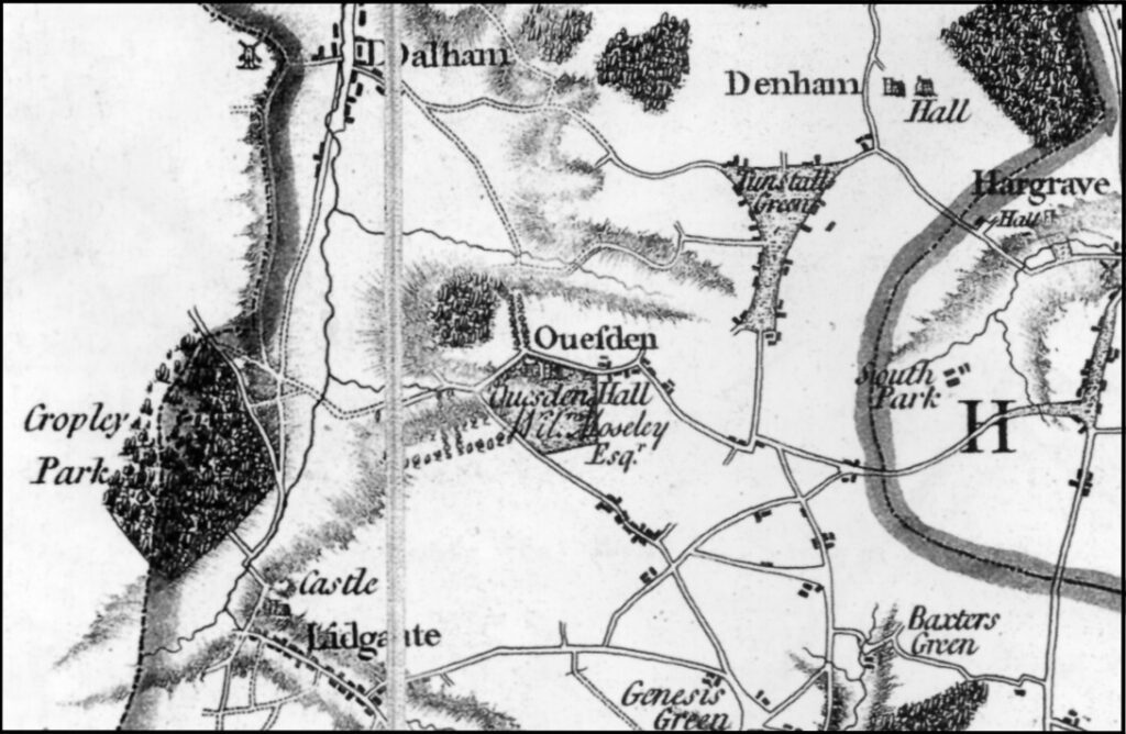
Hodskinson’s 1783 map shows the park with five sides bounded to the north and west by roads. The park appears not to extend eastward to Ousden village, stopping short near the home farm of the Hall. An avenue to the north ran east of Glumpsey Wood but appears to have been outside the park’s boundary, as was a double avenue to the west that was crossed by another running north to south. By 1816 the park had expanded towards the west, made possible by the removal of the road which became a footpath. The double avenue had disappeared to be replaced by a typical park landscape of the period bounded by a shelterbelt of trees. It is believed that William Emes (1729–1803), who designed the nearby park and gardens of Chippenham Hall and the walled garden at Walpole Hall in Cambridgeshire in the late 1790s, may also have designed the park and gardens at Ousden because a plan by Emes dated 1794 was listed in a private collection in 1958, although its whereabouts are unknown today. Emes was known for his work with trees and water, his trademark features included serpentine lakes with their ends concealed in woodland, single trees and clumps of trees in parkland with tree belts around the boundary. The date of the lost plan suggests that it was drawn up for the Moseley family who sold the estate some six years later in 1800. When or how much of Emes’s design was implemented is unclear, although many of his trademark features are shown on an 1816 map.
By the late-nineteenth century the shelterbelt had expanded out into the open parkland to become The Plantation. The 1884 OS map shows it to be a wood with a mix of deciduous and coniferous trees crossed by various paths or tracks, possibly used as recreational rides through wooded pleasure grounds. Within this woodland there is a large circular mound that could be the remains of a sixteenth or seventeenth century prospect mound. The area around the mound is shown on the 1816 map as open parkland with isolated standing trees that would have allowed clear views of the park from its summit. The mound would also have acted as a visual focus from the house, which is on rising ground to the north-east. The area to the north of the road, including the avenue running east of Glumpsey Wood, also appears to have been incorporated into the parkland landscape during the eighteenth century, although with the loss of the avenue.
In 1864 the Ousden Hall Estate extended to 943ha (2,330a) and an advertisement in the Solicitors Journal at the time of its sale describes the park studded with ‘noble oaks and other trees of large growth’… ‘The park, woodlands, and plantations afford excellent cover for game’.
By 1884 there were three main drives to the Hall. The principle drive was from the west and had specimen trees dotted along its length as it gently rose towards the north front of the house. The second was from the tree-lined lane off the road to the north that led to the parish church and beyond through the park towards Littly Wood before curving north-eastward to join the road east of the village settlement, although now at its centre. Maps suggest that this was the only entrance to have a lodge, which today survives as East Lodge (Grade II) and was built in the cottage orné-style around the middle of the nineteenth century.
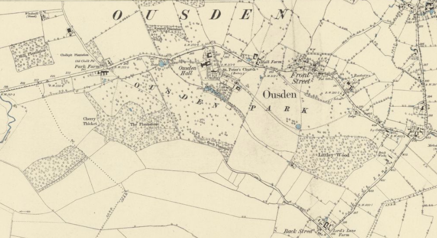
With the break-up of the Ousden Hall Estate around the time the Hall was demolished, both the eastern and western drives were lost and access to the site was solely from the north along the lane that passes the square eighteenth century dovecote in a field to the east. This lane continues past the entrance to Ousden House, the parish church and an adjoining walled garden, petering out before reaching Littly Wood. At this time much of the parkland was converted to arable and the walled garden south of the church was sold into separate ownership. For a number of years the Hall site lay derelict until part of the stable block was converted and extended to create Ousden House, retaining most of the gardens immediately around the site of the old house.
PLEASURE GARDENS
The 1812 enclosure map shows the Hall with lawns to the west and south with a line of trees separating it from the parkland beyond. The western drive passed through a copse of trees to arrive at the north entrance front. Within the gardens the ornamental lake south of the house was surrounded by trees. Davy on his travels around Suffolk in 1831 described Ousden Hall as ‘a respectable looking old house, in a well wooded lawn’.
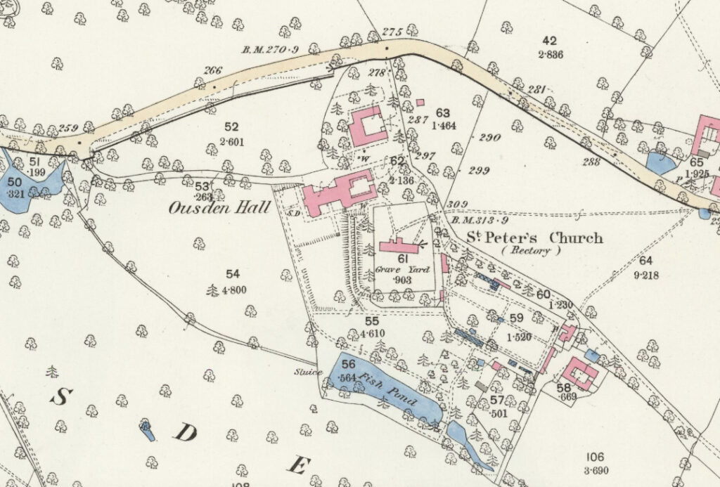
A copy of an eighteenth century estate map shows a U-shaped house with a U-shaped moat to its south. This moat had its east arm alongside the churchyard with a causeway at the south end giving access to a small enclosure called ‘Garden Pightle’ with two fishponds on its south side. Another estate map from the late 1830s shows an H-shaped house with the moat filled-in except for one arm, shown as a narrow canal next to the churchyard with a substantial flat-topped embankment on its west side. Today this embankment with a walkway lie in the grounds of Ousden House and have a line of yew trees along its western margin that are shown on a map dated 1885. Terraced walks of this kind were very fashionable during the seventeenth and eighteenth centuries suggesting it may be from that period, possibly at the time of rebuilding the Hall by the Moseleys in the mid-eighteenth century.
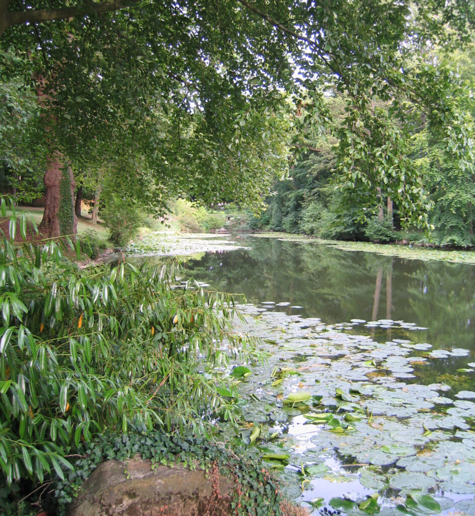
Following James Ireland’s death, an 1864 sales catalogue and advertisement in the Solicitors Journal mentions extensive pleasure grounds and gardens ‘sloping on the south to an extensive sheet of water, well stocked with fish’. This refers to the surviving large pond to the south of the Hall site, named on a number of maps as ‘fishpond’. At the time the steeply-sloping area immediately north of the pond was planted with a mix of coniferous and deciduous trees, the eastern portion possibly being an orchard. Today the planting survives, albeit in a slightly overgrown state but with little trace of the orchard, whilst the fishpond has been developed into an attractive lake with a smaller pond to the east.

During the nineteenth century there appears not have have been any formal planting to the rear of the Hall, suggesting park-like lawns came right up to the house. However, a photograph in the Spanton Jarmen Collection (K505/1870) dated 1908 shows some formal flowerbeds had been added both to the rear and west side of the house.
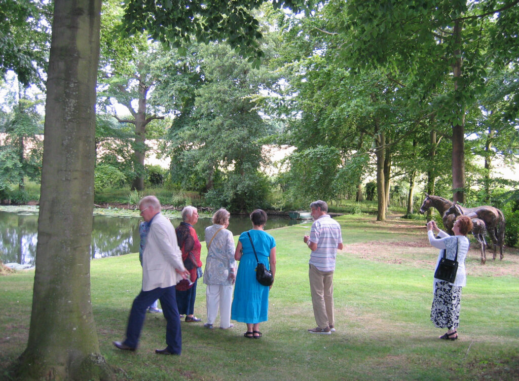
From the 1970s Alasdair and Lavinia Robinson developed the gardens around Ousden House and, having bought some of the surrounding land that was once part of the parkland to Ousden Hall, have created a series of garden rooms that include a crinkle-crankle yew alley with the clock tower as its focal point, herbaceous borders designed by Arabella Lennox Boyd, a moat garden, woodland and ornamental lake. The courtyard created by the stable buildings, now Ousden House, has been used to develop a sheltered formal garden from where there is a view of the dovecote.
THE WALLED GARDEN
Surviving eighteenth century household accounts of the Moseley family covering the years 1731–41 show regular payments to ‘the Gardener’, and a copy of an undated estate map from this period suggests that the area south of the churchyard now covered by the walled garden may have been an orchard at the time. The walled garden was built before 1812, possibly to designs by Emes, and constructed either for the Moseley family before 1800 or Hand family between 1805 and 1812. The 1864 sales catalogue following James Ireland’s death mentions ‘a well enclosed kitchen garden’ planted with ‘the choicest description of fruit trees’ [with] a vinery and conservatory’. Adjoining these was a gardener’s cottage and a number of stores and sheds.
Late-nineteenth century maps show the garden with perimeter and cross-paths. It had glasshouses for a vinery and conservatory that are mentioned in the 1864 sales catalogue. There was a further glasshouse outside the south-west facing wall, with an area for frames and paths leading down to the ornamental lake and skirting the churchyard towards the pleasure gardens and Hall.
With the break-up of the estate and the demolition of the Hall, the walled garden was sold into separate ownership. The gardener’s cottage has been extended and, although none of the nineteenth century glasshouses or paths have survived, the entrance gateways shown on the 1885 map can still be seen, including an ornate wrought iron gate that led into the pleasure grounds of the house. Today the garden is mainly laid to grass and used for grazing sheep.
SOURCES:
A Concise Description of Bury St Edmunds and its environs within a distance of ten miles, illustrated by engravings and woodcuts…, Longman & Co, 1827.
Barker, H. R., West Suffolk Illustrated, 1907.
Birch, Mel, Suffolk’s Ancient Sites Historic Places, 2004.
Brown C, Haward B & Kindred R, Dictionary of Architects of Suffolk Buildings 1800–1914, 1991.
Colvin, H. M., A Biographical Dictionary of British Architects 1600–1840, 1978.
Copinger, W. A., The Manors of Suffolk: The Hundreds of Lothingland and Mutford, Plomesgate, and Risbridge, Vol. 5, 1909.
Davy, David, Elisha, A Journal of Excursions Through the County of Suffolk, 1823–1844 reproduced by The Suffolk Records Society.
East Anglian Daily Times, 6 September 1952.
Fisher, D. R. (ed), The History of Parliament: the House of Commons 1820–1832, 2009.
Hoppitt, Rosemary, Deer Parks of Suffolk 1086–1602, 2020.
Martin, Edward, ‘Garden Canals in Suffolk’ in East Anglia’s History, Studies in Honour of Norman Scarfe, 2002.
Roberts, W. M., Lost Country Houses of Suffolk, 2010.
Suffolk Gardens Trust, Walled Kitchen Gardens Recording Group, Ousden Hall Walled Garden, now Gardener’s Cottage and Walled Garden, February 2016, unpublished document.
The Solicitors Journal and Reporter, Vol. 8, 1864.
White, William, History, Gazetteer and Directory of Suffolk, 1844, 1855.
Williamson, Tom, Suffolk’s Gardens and Parks, 2000.
St Edmundsbury Chronicle www.stedmundburychronicle.co.uk?Chronicle/1813–1899.htm (accessed August 2023).
Suffolk County Council, http://www.suffolklandscape.org.uk/landscapes/Undulating-estate-farmlands.aspx. (accessed June 2016).
https://en.wikipedia.org/wiki/High_Sheriff_of_Suffolk (accessed June 2016).
1783 Hodskinson’s Map of Suffolk in 1783.
1812 Parliamentary Enclosure Award map, awarded 1816.
1816 original preliminary drawing for the 1st Edition Ordnance Survey map; British Library Online Gallery http://www.bl.uk/onlinegallery/onlineex/ordsurvdraw/n/zoomify82207.html (accessed 6 February 2016).
1836 Ordnance Survey map.
1884 (surveyed 1884) OS map.
1885 (surveyed 1884) OS map.
1903 (revised 1901) OS map.
1952 (revised 1950) OS map.
2023 Google aerial map (Imagery © Bluesky, CNES / Airbus, Getmapping plc, Infoterra Lts & Bluesky, Maxar Technologies, Map data © 2023).
Heritage Assets:
Suffolk Historic Environment Record (SHER): OUS 02, OUS 003, OUS 04, OUS 007, OUS 08, OUS 010, OUS 014, OUS 028, OUS 032, OUS 33, OUS 041, OUS 042, HRG 009.
Church of St Peter (Grade I). Historic England No: 1227383.
Clock Tower to south of Ousden House (Grade II). Historic England No: 1236427.
Dovecote, formerly to Ousden Hall (Grade II). Historic England No: 1227427.
Stables, formerly to Ousden Hall [now Ousden House] (Grade II). Historic England No: 1227384.
East Lodge (Grade II). Historic England No: 1227533.
Suffolk Record Office (now Suffolk Archives):
SRO (Bury St Edmunds) HA 543/400, Mackworth-Praed family of Ousden Hall, estate and household papers, 1737–2000.
SRO (Ipswich) BA500/F/6/2/81, West Suffolk Quarter Sessions Highway Diversion Order Ousden, April 1835.
SRO (Bury St Edmunds) HD 526/106/4, Sales particulars of Ousden Hall, 1864.
SRO (Bury St Edmunds) HA543/2/2/4/1/17, Correspondence and accounts for alterations and additions, c. 1913.
Site ownership: Private
Study written: September 2025
Type of Study: Desktop and site visits 2006, 2015, 2016.
Written by: Tina Ranft
Amended:
