(later known as Plumpton House. Now divided into three separate properties)
Parish: WHEPSTEAD
District Council: WEST SUFFOLK (formerly St Edmundsbury)
TL 816 579
Not open to the public
Plumpton Hall (Grade II) – later referred to as Plumpton House and now divided into three separate properties – stands in an isolated, well-wooded position south-west of Whepstead, a cluster of houses forming a village hamlet in a parish with scattered settlement. It is c. 7km (4.5mls) south-west of Bury St Edmunds on the clayland plateau of Suffolk. Hay, Plumpton and Woolmer Woods are ancient woodlands to the south and west of the Plumpton Hall site, which were probably integrated into Plumpton Park c. 1800. The River Lark, which rises in Plumpton Wood, runs north-eastward close to the house.
Owned by the Abbey of Bury St Edmunds as a dairy and orchard, after the Dissolution Plumpton passed through several owners and it is believed the Drury family from Doveden Hall north of the site, built the timber-framed core of the present building in 1537.
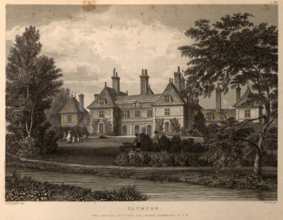
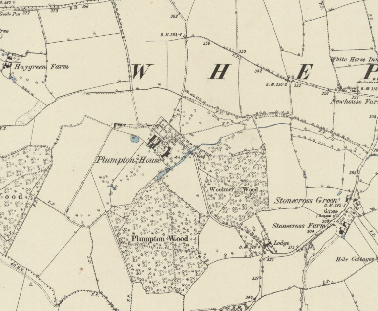
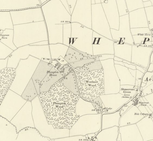
In 1795 Plumpton farmhouse was bought by Sir Francis Thomas Hammond, Equerry and Clerk Marshall of the Royal Stables of the Prince Regent. Influenced by the fashion of the day, Sir Francis employed a French architect to redesign the house to look like a French chateau, the work taking place between 1800 and 1807 and shown in an engraving in John Gage’s The History and Antiquities of Suffolk, Thingoe Hundred published in 1838. This depicts the River Lark having been widened in front of the house and used as an ornamental feature within the gardens not unlike a garden canal. It has been suggested that this may originally have been a stew pond for the monks of the Abbey and before that a moated site. Gage also produced a map that shows the surrounding parkland dotted with trees and incorporating the ancient woodlands. Still in use today, the 0.80km (0.5mls) long south drive is depicted passing between Plumpton and Woolmer Woods before the route opens out to give a view over the river of the garden front of the house. From here it bridges the river and curves around a lawn to the north-facing entrance front. The other is off a road from the east that linked Whepstead village with today’s Chedburgh Road. This was later converted into a footpath with the loss of the east drive. Gage’s map also shows a rectangular enclosure near the stables representing the square walled garden and orchard that is more clearly shown on the 1884 OS map. In later life it is believed Sir Francis (also sometimes known as Sir Thomas) allowed the property to become overgrown and uninhabitable. He died in 1850 and for a few years the house was left empty.
Although named ‘Plumpton Hall’ on the 1843 tithe apportionment, by 1844 the property was being referred to as ‘Plumpton House’ rather than Plumpton Hall. In 1856 Plumpton House was bought by William Robert Bevan, a member of a local banking family, who substantially renovated the property, removed some of the ornamentation and is recorded on the 1861 census as living there with his wife Sara, eight children and a number of servants. A series of photographs from the Spanton Jarman Collection, probably taken in the 1870s show the gardens little changed from Gage’s 1836 engraving, albeit the house was now rendered with much of the earlier ornamentation removed. They show a lawn stretching down to the ‘canalised’ stream with a few ornamental trees. The rear of the house had a small terrace level with the lawn with urns and pots marking the edge. One shows the stables designed in the French chateau style to match the house. The courtyard between the house and stable buildings has a circular perimeter gravel drive with grass divided into a cruciform shape by paths and central column with statue on top. Also shown is part of the west wall of the walled garden, which is c. 3m (10ft) high, although the top courses of brick appear to be a slightly different in colour suggesting its height had been raised at some time. Also in the collection are a photograph of the parkland with trees of a variety of ages, some quite ancient and showing signs of pollarding, and a shady track c. 2.5m (8ft) wide flanked by dense woodland with two boxes that appear to be storage for bird food and a gamekeeper in the distance. This photograph would have been taken in one of the ancient woods within the park. The 1884 OS map shows a lodge (Grade II) at the south entrance. At this time this was a house dating to the sixteenth century that was heavily restored and converted into two thatched cottages in the Elizabethan style c. 1900. By 1884 a new north track had been established that zig-zagged through fields to access the stables and walled garden, which at the time had perimeter and cross-paths.
After the death of the Bevans the Plumpton Estate changed hands in 1890 and again in 1908 when it was sold to John Soame Austen, solicitor and leading figure in the City of London. John made alterations to two wings of the house c. 1911. A lodge in the Elizabethan style with central archway flanked by a cottage on either side at the entrance to the north track is believed to have been built around this time, although a late-nineteenth century date has also been suggested (Grade II). Thus, the earlier track was straightened and upgraded to an entrance drive. This has a well-house immediately to the east that is also included in the listing. Within a few years the house was taken over and used as a Red Cross Hospital during World War I. In 1942, during World War II the estate passed to Harold Drayton, a protégé and business associate of John.
Harold died in 1966 and his wife in 1971. Afterwards the estate was broken up, much of it going to the Jump farming family. In the 1990s the house was divided into three and the stables and cottages on the site sold as separate residential properties with each property allocated a portion of the pleasure grounds surrounding the house, sometimes with an option to buy further land that was once part of the parkland.
Today the turning circle created between the stables and courtyard north of the house in the nineteenth century survives and the layout of the pleasure gardens, although split between the properties, shows the ghost of the nineteenth century plan implemented by the Hammonds and the survival of the ‘canalised’ river to the rear of the original house. The central property of the original Plumpton Hall has taken the name Plumpton House. It is the largest of the three and is the oldest part of the building dating back to the sixteenth century. In 2020 it was for sale with c. 1ha (2.44a) of pleasure gardens and an option to buy land, once part of the parkland but by then converted to paddocks. North and south lodge are now in separate ownership with new drives created to the north serving converted properties and new farm buildings, including a house that has taken the name Plumpton Hall attached to Plumpton Hall Stud, which were developed on land to the north of the house. Although the original parkland is now divided between a number of owners and often converted for arable use, many eighteenth and nineteenth-century trees survive in the surrounding fields and the ancient woodland has been preserved.
SOURCES:
Gage, John, The History and Antiquities of Suffolk, Thingoe Hundred, 1839.
Jackson-Stops & Staff Sales Particulars, Plumpton House, 2020.
Steward, Brian, paper on Plumpton House, Whepstead, 2014, accessed from http://whepstead.onesuffolk.net/our-village/history/buildings/plumpton-house (accessed January 2021).
White, William, History, Gazetteer and Directory of Suffolk, 1844.
Bury Past and Present Society. https://www.burypastandpresent.org.uk/spanton-jarman-project/
http://whepstead.onesuffolk.net/our-village/history/buildings/plumpton-house (accessed January 2021).
Census: 1851, 1861, 1871, 1881, 1891, 1901.
1843 (surveyed 1843) tithe map and apportionment.
1884 surveyed 1884) Ordnance Survey map.
1905 (revised 1903) OS map.
1952 (revised 1950) OS map.
2025 Google aerial map (Imagery ©2025 Airbus/ Copernicus, Maxar Technologies, Map data © 2025).
Heritage Assets:
Suffolk Historic Environment Record (SHER): WHP 003, WHP 013, WHP 015, WHP 058.
Plumpton Hall, Whepstead (Grade II). Historic England No: 1278581.
South Lodge (Grade II). Historic England No: 1278589.
Gatehouse to Plumpton House [Hall] including well-house immediately east (Grade II). Historic England No: 1231002.
Suffolk Record Office (now Suffolk Archives);
Suffolk Archives (Ipswich) K997/75/1, K997/109/10, K997/120/7. Plumpton Hall, Whepstead, photographs of soldiers from the Walter Burrell Photographic Archive 1914–19.
Site ownership: Private
Study written: August 2025
Type of Study: Desktop
Written by: Tina Ranft
Amended:
