Parish: POLSTEAD
District Council: BABERGH
TL 988 381
Not open to the public
On an eminence overlooking the River Box to the south, Polstead Hall (Grade II*) and twelfth century St Mary’s Church (Grade I) lie in a former deer park with the village of Polstead to the east where there are two large ponds, Polstead Ponds Farmhouse (Grade II) and a dovecote (Grade II). The site is c. 4.8km (3mls) north of the River Stour, which forms the county boundary with Essex, and c. 2.5km (1.5mls) north of Stoke-by-Nayland. This is an area of wooded and fairly steep valley sides with the valley bottoms filled with gravel, sand and silt deposits and clay soils on the edge of the higher ground of Suffolk’s clayland plateau. Near the parish boundary with Shelly to the east of the Hall site, Mark Wood, Long Wood and Hazel Grove are ancient woodlands. In the early-nineteenth century Polstead was renowned for its black cherries that is commemorated in place names such as Cherrytree Farm to the south-east of the park, although few cherry orchards remain today.
OWNERS OF POLSTEAD HALL AND PARK
The Waldegrave family, whose home was at Smallbridge Hall in Bures, held the manor of Polstead until they sold it to the Brands in 1598. By the beginning of the eighteenth century it was owned by Jacob Brand, who was succeeded by his son William Beale Brand in 1756. On William’s death his widow Anne inherited Polstead Hall and on her death in 1814, with no children to inherit, it passed to William Brand’s great nephew Thomas William Cooke (Cope) Esq., son of Thomas Cooke rector of Bildeston. Thomas died some eleven years later. Thomas’ widow Marianna, the daughter of Richard Matthews Esq. of Wargrave, Berkshire, succeeded and later married Charles Tyrell, a member of the rich and powerful Tyrell family of Gipping Hall and Plashwood near Haughley. In 1828 Charles and Marianne made their home at Polstead, but on Marianne’s death in 1849 Polstead passed to her nephew, the Revd Thomas Alexander Matthews, who assumed the name Cooke and moved to Polstead as a non-practicing clergyman and landowner. It stayed in the Cooke family until 1940, when it was for sale after the death of Walter Matthews Cooke. Since then it has changed hands on a number of occasions.
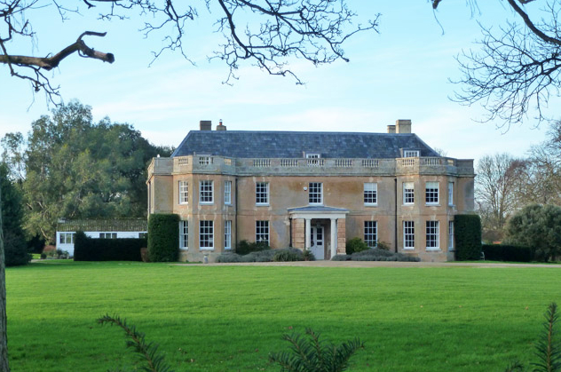
THE HALL
The Brand’s sixteenth-century manor house was extensively rebuilt in the late-eighteenth century, although gables to the rear and a remarkable surviving wall painting dated to 1550–60 in one of the bedrooms appear to be survivals from the period in which the Waldegraves were Lords of the Manor. Further alterations took place in 1816–19 for Thomas William Cooke to designs by the architect William Pilkington that completed its transformation from Tudor to white brick Georgian mansion with its balustraded parapet and cornice. Surprisingly the tithe map dated 1838 accompanying the 1842 tithe apportionment appears to show the U-shaped Hall with corner turrets suggestive of remains of the Tudor building, although this may have been a cartographic misrepresentation.
Probably after the 1940 sale, later alterations were made to the house that included the loss of a wing to the south. This is thought to be have been a ballroom with bedrooms above that was added in the early-nineteenth century. In 1944 Ipswich Borough Council put forward plans for extensions and new dormitory at the Hall, so presumably they either owned or leased the house, and by 1948 the house was run as a guest house. Today Polstead Hall is once more a private residence.
THE PARK
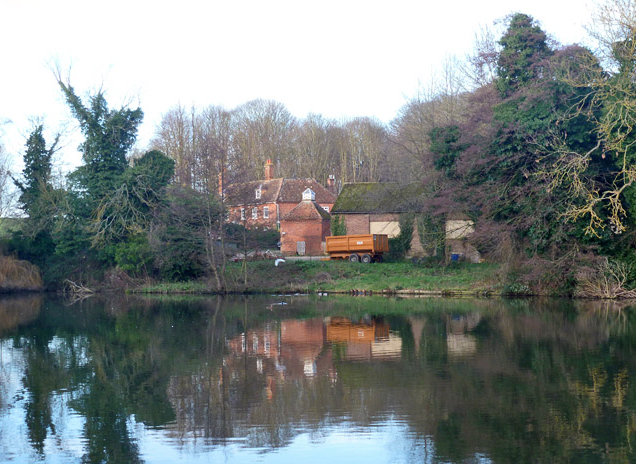
Polstead had a moderately-sized medieval deer park first recorded c. 1300. The park is shown on Saxton’s map of 1575 and later on Hodskinson’s 1783 map, which depicts the church south-east of the Hall on the park boundary. It possibly extended beyond the road to the east to include the two ancient ponds, Polstead Ponds Farmhouse and the square, red brick eighteenth century dovecote. The farmhouse is a timber-framed building with a later eighteenth century red brick front façade and date panel of 1760 bearing the initials W.B.B. for William Beale Brand who owned Polstead Hall and Park at that time.
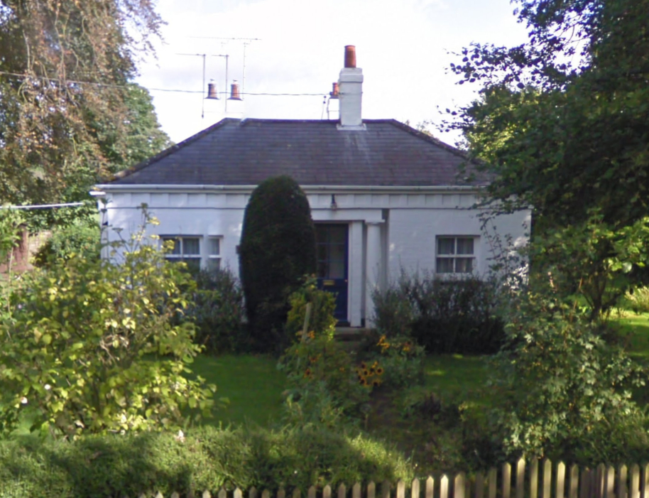
By the time of Polstead’s enclosure award in 1817 the park had expanded to c. 40ha (100a) by taking in an area of farmland to the south-east beyond the church. Shared with the church, the main entrance into the park was opposite the two large ponds in the village. By 1838 a new curving south drive and southern entrance lodge (Grade II) were added with the drive passing east of the church and house to continue north-westward, although without a lodge at its northern entrance. Listed on the tithe apportionment of 1842, the park and southern entrance lodge were tenanted at the time, while the house, its associated gardens and yard, plus an irregularly-shaped kitchen garden bounded by trees beside the southern entrance were used by the Tyrell family. By this time the church was surrounded by trees. Further trees formed a shelterbelt along part of the park’s eastern boundary giving the Hall privacy from the village. A further belt wrapped around the boundary to the south. To the north and west the boundary was dotted with trees and to the south there was a low-lying area beside the River Box called ‘Park Meadow’. Two small circular plantations lay within the park west of the house with a clump of trees south of the church and a few individual trees dotted throughout. The park is recorded as having a herd of fallow deer throughout the nineteenth century. By 1892 it numbered eighty, which had dropped to fifty-five at the time of the 1940 sale, the sales particulars listing deer and other parkland of 43ha (106a).
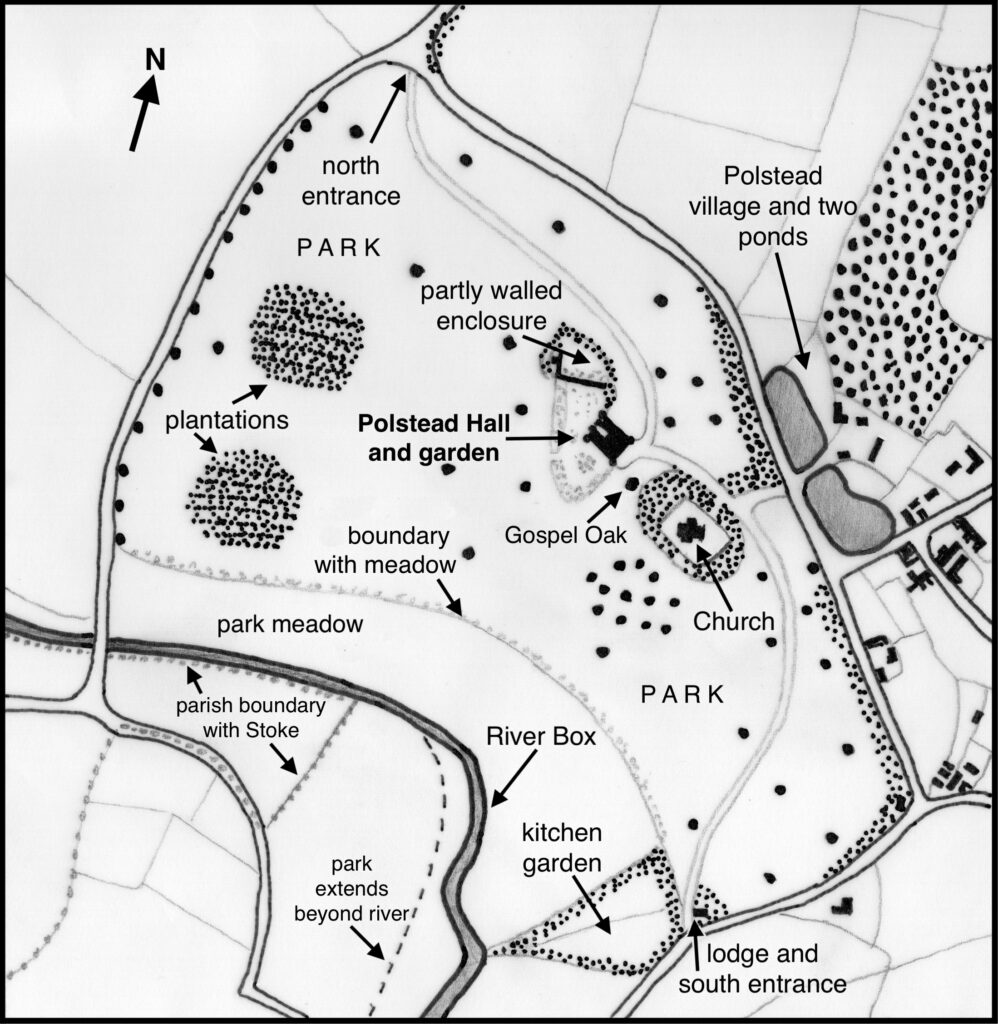
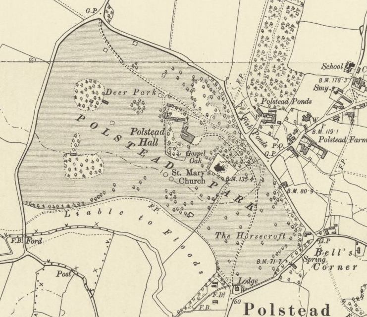
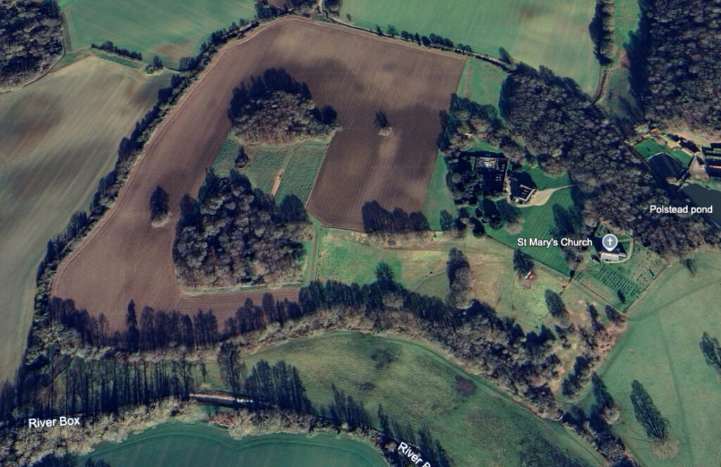
Little changed in the park during the early part of the twentieth century. In 1978 Oliver Rackham recorded the park to be mostly cultivated, noting it was said to have been disparked in World War II, leaving the remains of the park pale and ancient pollarded oaks on its northern boundary. At the time he said there were no other old large trees in the park, except the partly-alive remains of the Gospel Oak lying between the Hall and church that was reputed to have been the oldest oak in Suffolk. Today it is apparently dead but its trunk is still standing. Much of the park is now arable leaving a small area of parkland, mainly to the south of the house. The original north and south drives have gone with access to the Hall now off the lane that leads to the church from the eastern entrance with the shelterbelt of trees between the house and road expanded to give additional seclusion.
THE PLEASURE GARDENS
The tithe map shows the pleasure gardens within an L-shaped enclosure to the south and west of the house. The simple planting layout changed little over the following forty years when it is shown on the 1885 OS map with a distinct line of hatching to its west side that represented the land dropping down to the garden edge from the parkland to the west that was described by H. R. Barker in 1907 as the ‘Well Garden’… ‘a very excellent specimen of this old-time arrangement, it is situated in a very deep hollow, and quite surrounded by trees, forming a secluded retreat’. Another enclosure is separated from the gardens by a wall and attached buildings with a short return northward and a building against the outside, perhaps the remains of walled enclosures associated with the original sixteenth century house. Attached to the south side of the dividing wall there was a glasshouse that was probably an orangery accessed from the main pleasure gardens. Walls and a curving eastern belt of trees enclosed the northern area, which by 1885 was accessed off the northern drive in its north-west corner and was used as a stable courtyard.
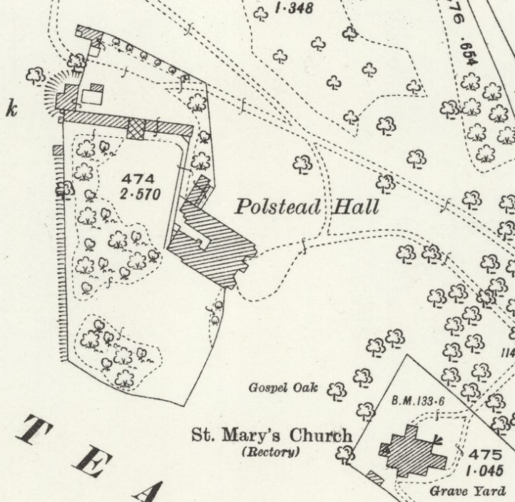
The 1926 OS map gives a clearer picture of the stables and yard enclosure with access drives from the west and north-east. An orangery, first shown on the 1885 map, sits in the centre of the range of buildings forming part of the stable yard. This glasshouse would have been accessed from both the pleasure gardens to the south and the working enclosure to the rear. The garden layout and planting had changed little over the preceding forty years, except the loss of a flowerbed south of the house. From the south elevation of the house there were parkland views over a lawn and framed by a clump of trees and shrubs, and a larger clump created the secluded lawn described by Barker to the west of the house.
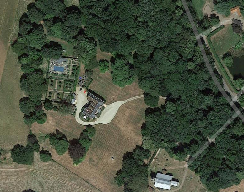
With the loss of the house’ southern wing during the twentieth century, the drive now wraps around the south side of the house to give an area to the rear for car parking and garages. The southern pleasure garden has been reduced in size after the area was converted to parkland bounded by mature trees. The pleasure gardens are now solely north-west of the house and have been divided into two. The northern section is a courtyard for a swimming pool and ancillary buildings and the southern laid out to a formal geometric plan with perimeter and cross-paths and planted with specimen trees surrounded by grass in the quadrants. The stable courtyard enclosure is now laid to grass and surrounded by mature trees.
SOURCES:
Barker, H. R., West Suffolk Illustrated, 1907.
Birch, Mel, Suffolk’s Ancient Sites Historic Places, 2004.
Colvin, H. M., A Biographical Dictionary of British Architects 1600–1840, 1978.
Copinger, W. A., The Manors of Suffolk: The Hundreds of Babergh and Blackbourne, Vol. I, 1905.
Fisher, D. R. (ed.), The History of Parliament: the House of Commons 1820–1832, 2009.
Hoppitt, R., The Development of Parks in Suffolk from the 11th to 17th Centuries. (PhD thesis UEA), 1992.
Martin, J. R., ‘The distribution and status of Fallow Deer in Suffolk, with particular reference to the south-west’ in Suffolk Natural History, Vol. 47, January 2012. Quoting figures given by Joseph Whitaker in A Descriptive List of the Deer-Parks and Paddocks of England. 1892.
Rackham, Oliver, Notebook 244 covering 11 May to 11 July 1978 (CCCC14/6/2/1/244), Corpus Christi College Cambridge Archives, https://archivesearch.lib.cam.ac.uk/repositories/18/archival_objects/817955 (accessed February 2021).
Sandon, Eric, Suffolk Houses, A Study of Domestic Architecture, 1977.
Suffolk County Council, Suffolk Landscape Character Assessment, Rolling Valley Farmlands, August 2010.
Suffolk Institute of Archaeology and History, Proceedings, Excursions, Volume XXIV Part 3, 1948.
The Gentleman’s and London Magazine…, 1741.
White, William, Directory of Suffolk, 1844.
Census: 1841, 1871, 1881, 1891, 1901, 1911.
1783 Hodskinson’s Map of Suffolk in 1783
1838 (surveyed) tithe map and 1842 apportionment.
1885 (surveyed 1885) Ordnance Survey map.
1904 (revised 1902) OS map.
1926 (revised 1924) OS map.
2023 Google aerial map (Imagery © Bluesky, CNES / Airbus, Getmapping plc, Infoterra Lts & Bluesky, Maxar Technologies, Map data © 2023).
Heritage Assets:
Suffolk Historic Environment Record (SHER): PLS 015, PLS 019, PLS 057.
Dovecote to south of Polstead Ponds Farmhouse (Grade II). Historic England No. 1182448.
Park Lodge (Grade II). Historic England No. 1037044.
Polstead Hall (Grade II*). Historic England No. 1037049.
Polstead Ponds Farmhouse (Grade II). Historic England No. 1037052.
St Mary’s Church (Grade I). Historic England No. 1284554.
Suffolk Record Office (now Suffolk Archives):
SRO (Bury St Edmunds) FB78/C/1/1 Notes on the family of John Brand, 17th century to 1788.
SRO (Ipswich) HA 108/9/9 Printed Bill for enclosing Stoke by Nayland, Nayland, Wissington, Assington and Polstead, 1815.
SRO (Bury St Edmunds) HD 1180/270 Sales Particulars, 1940.
SRO (Bury St Edmunds) EF 503/5/1/625. Ipswich Borough Council plans for extensions and new dormitory, 1944.
The National Archives, Kew PROB 11/2110/376 Will of Mary Anne Tyrell, Wife of Polstead Hall, 6 March 1850.
Site ownership: Private
Study written: August 2023
Type of Study: Desktop
Written by: Tina Ranft
Amended: May 2025
