(Also known as Redhouse Park. House known as The Red House demolished 1937)
Parish: NON-CIVIL PARISH (previously in St Margaret’s parish)
District Council: IPSWICH BOROUGH COUNCIL
TM 172 464
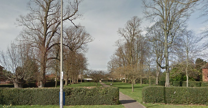
Remaining replanted section of the route of an avenue is open to the public as a ‘pocket park’
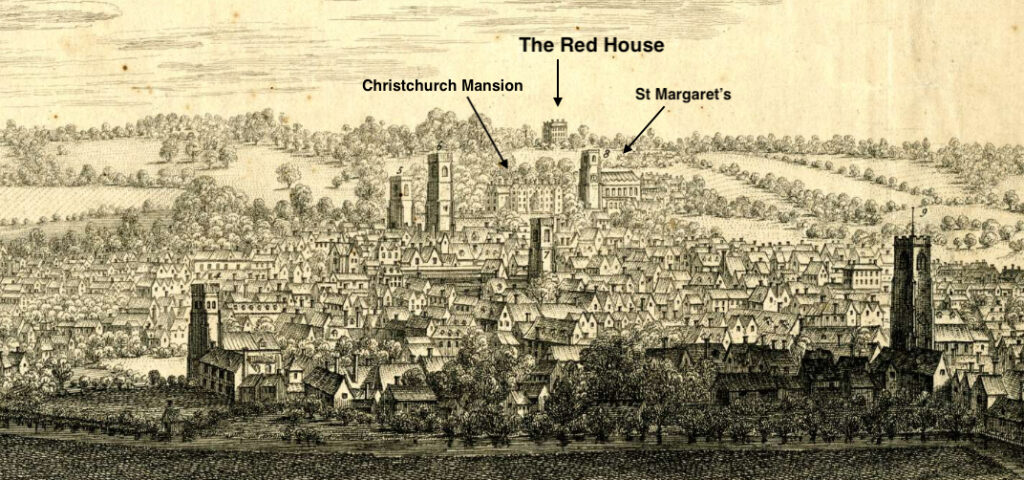
Demolished in 1937, The Red House mansion was c. 2.4km (1.5mls) north-east of the centre of Ipswich in the old parish of St Margaret’s, at its height the largest parish in Ipswich. The house originally stood in countryside with fine views of Ipswich town below. Its park lay between the roads from the centre of Ipswich northward to Westerfield and Tuddenham.
The Edgar family had acquired land in the parish of St Margaret’s by 1641, expanding their holding over the next two centuries. The central three-storey block of the mansion was probably built c. 1658 by Thomas Edgar (d. 1677) who married Agatha, heiress of Borodaile Mileson (also spelt Borowdale) of Little Haugh Hall in Norton, Suffolk. A painting in the Colchester and Ipswich Museums Service: Ipswich Borough Council Collection of unknown date, but believed to be from the mid- to late-eighteenth century, shows an elegant flat-faced entrance front to the house of two storeys plus attic. The Georgian style may suggest the seventeenth century house had been re-fronted and extended during the eighteenth century. The house was raised above the surrounding ground, presumably accommodating cellars, with a grand central doorway at the top of a flight of steps. On the ground floor there were three windows either side of the doorway and a seventh window above the doorway on the first floor. Two simple side wings with no ornamentation are shown with a barn-like building to the right and dense planting of trees and shrubs behind. In front of the house were small conifers marking the edge of the path to the steps. A terraced lawn was fenced off from the parkland where cattle grazed. Large, mature trees were to left and right of the parkland area in front of the house, suggestive of the start of an avenue.
Hodskinson’s 1783 map of Suffolk shows a large park on the site but little detail except naming a ‘Folly’ just outside its boundary to the south, and east of the road to Tuddenham. The nature of the folly is unknown although it is likely to have been viewed from the house as an ‘eyecatcher’ on the central axis of the mansion. Later maps show it to have been a moated site at the south end of an avenue of trees.
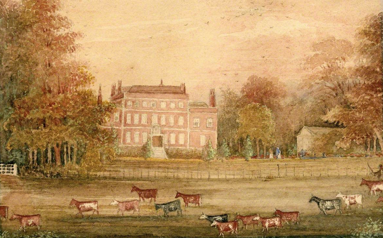
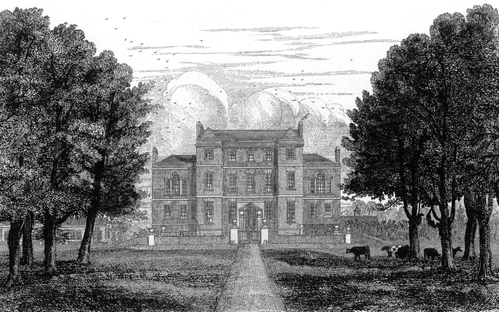
The Red House was the home of the Revd Mileson Gery Edgar when Henry Davy produced an engraving in 1840. Compared to the earlier painting, the front of the house had changed substantially and the central core now had two square bays the full height of the building instead of the plain front of the earlier depiction. By this time Venetian-style windows had also been added to the side wings. In front of the mansion there was now a small front courtyard separated from the parkland by railings with piers topped by ball finials. Cattle are shown grazing in the parkland and a double avenue, centred on the house, flanks the driveway. To the east (right) there was a low building with clock tower representing the stable yard and coach house. To the west there was a freestanding building with Venetian-style windows to match the wings, which was probably built at the same time and appears to be an orangery with a glass roof.
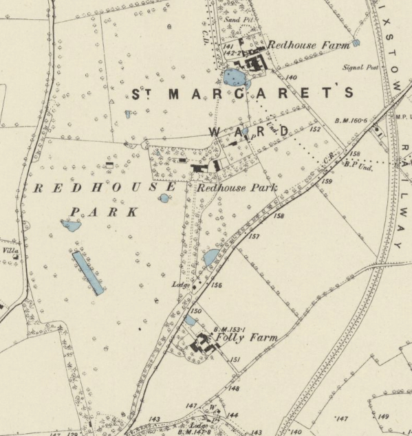
By the time of the tithe map surveyed only eight years after the 1840 engraving, a turning circle had replaced the courtyard in front of the house. The map shows the orangery with gardens to the rear and west of the mansion. Beyond the stables to the east there was a rectangular garden enclosure, later referred to as a walled garden. Within the parkland to the south-west of the mansion there was a lozenge-shaped ornamental pond or ‘canal’ with an irregularly-shaped water feature attached to one end. Canals were seen as a display of wealth and status, particularly in the first half of the eighteenth century, which suggests it may have been created, possibly from a natural water feature, when the wings were added to the house. It survived until sometime after 1928. In 1848 the Revd Edgar also owned the site of the folly, although the other land east of the Tuddenham Road was owned by the Fonnereau family. Later, William Neale Fonnereau purchased ‘Folly Farm’ and went on to restore and improve the house, rechristened it ‘The Moat’ and lived there until his death in 1904. The Revd Edgar died childless in 1853 leaving the estate to his widow Elizabeth.
By 1884 the OS map published that year shows shelterbelts of trees giving privacy along the eastern and western sides of the park that was dotted with freestanding trees. A lodge had been added at the southern end of the tree-lined entrance drive, which now split to include a side drive directly through a block of trees to the stable yard. The pleasure gardens consisted of a lawn with winding path through trees and shrubs, although soon after a more compartmentalised layout had been created with the orangery as a centrepiece and perimeter and cross-paths.
After Elizabeth’s death in 1890 the beneficiary, Captain Mileson Edgar, let out the mansion and on his death in 1935 the now derelict house, gardens and estate were broken up and for sale. Sales particulars describe the stable block with its clock tower, gardener’s cottage and three-quarters of an acre walled garden with vinery. The southern half of the 102ha (252a) estate was sold for housing, the sales particulars describing the park as having ‘belts of trees and studded with magnificent oaks offering attractive residential sites’. The mansion was demolished soon after and the borough council constructed Valley Road, an Ipswich northern urban relief road, which cut Red House Park in two. Houses and bungalows were constructed over the southern section of the park. To the north of Valley Road, Bromeswell Road and Chelsworth Avenue were built on the site of the mansion and walled garden with the northern parkland now cultivated fields. On the roundabout at the Valley Road junction for Tuddenham lies Cransfield Court (Grade II), a group of almshouses designed by Cautley and Barefoot for the Cranfield family charitable settlement and built 1938–9. The original home farm of the Red House estate is now Brooke Farm Livery.
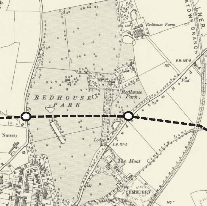
Today part of the route of the double avenue has been preserved north of the relief road as a small ‘pocket park’ with public access, although the present avenue of trees appears mainly planted in the twentieth century. The cultivated fields to the north are presently being considered as part of plans for Ipswich Garden Suburb housing development. This is split into three ‘village’ neighbourhoods. Fonnereau and Henley Gate Neighbourhoods have Planning Permission and building has commenced with the proposed Red House Neighbourhood element currently (as of June 2025) under consideration. This could see the last vestiges of Red House Park and a number of mature and veteran trees originally in the park under treat.
SOURCES:
Biographical History of Gonville and Caius Colleges, Vol. II, 1713–1898.
Birch, Mel, Suffolk’s Ancient Sites Historic Places, 2004.
Kelly’s Directory, 1921.
Roberts, W. M., Lost Country Houses of Suffolk, 2010.
Ipswich Borough Council, Parks Character Area https://www.ipswich.gov.uk/sites/ipswich/files/m-files/urban_park_2020.pdf (accessed 2020)
The Cobbold Family History Trust https://family-tree.cobbold.com/people,view,231 (accessed 2020)
Census; 1841, 1851, 1871, 1901
Hodskinson’s Map of Suffolk in 1783.
1848 tithe map and apportionment.
1884 (surveyed 1881 to 1882) Ordnance Survey map.
1905 (revised 1902 to 1903) OS map.
1928 (revised 1924) OS map.
Heritage Assets:
Suffolk Historic Environment Record (SHER) No: IPS 459
Cransfield Court (Grade II), Historic England No: 1379955.
Suffolk Archives (previously Suffolk Records Office):
(SA) HA 247, Edgar Family Papers, 1482–1893.
(SA) HA 445/4/2/10, ‘The South-West Prospect of Ipswich, in the County of Suffolk’ by Samuel and Nathaniel Buck, 1741.
(SA) HD 245/6, Plan of south side of Red House Park, the property of Mrs Elizabbeth Edgar, 1856.
(SA) HE 402/1/1881/36, Plan of The Folly, 11 May 1881.
(SA) K 681/1/262/1478, photograph of double avenue of lime trees at Red House Park, early 21st century.
(SA) HE 402/1/1936/16, Red House Park Estate building land, 1 July 1936.
(SA) HD 2833/1/SC242/85, Sale particulars for Red House Estate, mansion and grounds, Red House Farm, 28 April 1937.
Site ownership: Multiple private ownership. Route of avenue Ipswich Borough Council.
Study written: June 2025
Type of Study: Desktop
Written by: Tina Ranft
Amended:
