Parish: REYDON
District Council: EAST SUFFOLK (previously Waveney)
TM 480 783
Not open to the public
In an area known as the Sandlings in north-east Suffolk, Reydon is close to the coast c. 1km (0.5mls) north-west of Southwold. The River Blyth forms the parish’s southern boundary at Reydon Marshes. The parish is home to Reydon Wood, ancient coppiced woodland, probably the remains of Reydon deer park first documented at the end of the thirteenth century. With a seventeenth century core, Reydon Hall (Grade II) lies close to the wood, but there was once an older manor house to the south-east, probably where Old Hall Farm stands today and named on Hodskinson’s 1783 map, with the present Reydon Hall near to the parish boundary with Wangford west of the village and marked as the home of Revd M. Ewen.
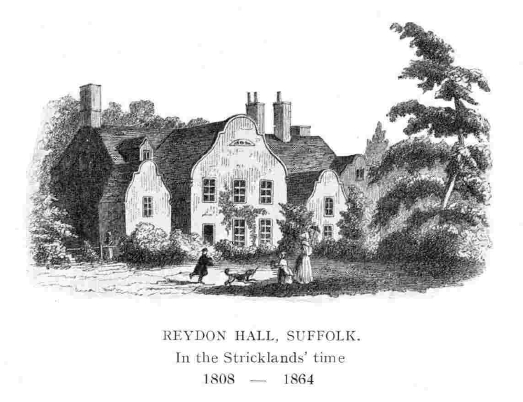
The present house is believed to have been built in 1682 by Thomas Ewen, staying in the family until 1808, by which time the Reydon Hall Estate extended to 283ha (700a). Until the mid-nineteenth century only the seventeenth century east wing of the house with its Dutch gables existed plus eighteenth century stables. It was bought by Thomas Strickland after he moved his family from London where he was a successful wine importer. Thomas lost money in a bad business investment and after his death in 1816 the family were left in financial difficulties, described by Susanna Moodie as making ‘a brave attempt to dignify genteel poverty and to live up to a social position Thomas Strickland had created for his family’, but they struggled to maintain their property. A literary family, Thomas’s daughter Agnes went on to become a well-known author and poet, best known for her Lives of the Queens of England and her sisters become famous for their writings after emigrating to Canada with their husbands.
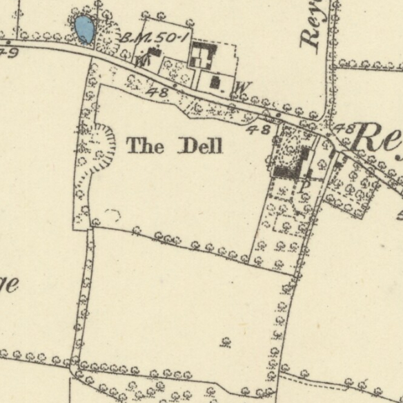
By the time of the tithe apportionment in 1841 the property was known as White House and much of the estate land had been sold. It included the house, ornamental grounds, stables, various outbuildings and just 30ha (74a) of arable and pasture land. The tithe map shows the house lying in the north-east corner of a small park. It had an entrance courtyard with circular turning circle in front of the house and a small area of garden to the rear. Stables lay adjacent to the house with a small irregular enclosure, much like a kitchen garden, to the rear. To west and south the park had shelterbelts of trees along the northern boundary with the road, part of the western boundary with a small wooded hollow, possibly an old pit, and along the southern boundary. The park-like area was divided in two, probably reflecting old field boundaries.
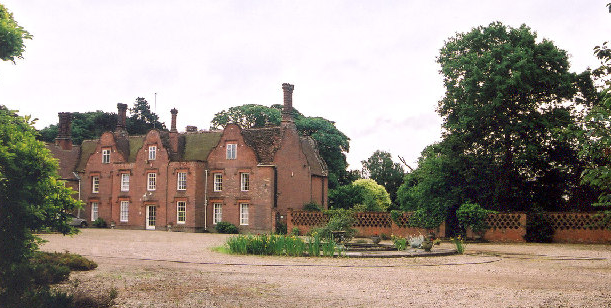
After Thomas Strickland’s widow died in 1865 the property was sold to Bradley Wilmer, although after his death in 1886 it returned to the Ewen family when bought by the Revd John Norris Frederick Ewen (d. 1908), Rector of Frostendon. Both men appear to have played their parts in renovating and enlarging the house to the west. The 1883 OS map shows the entrance forecourt and parkland much as it had been some forty years earlier with an additional garden enclosure attached to the rear of the house and an orchard east of the stables. By the beginning of the twentieth century the rear gardens are shown on the 1903 OS map to have been widened by enclosing a small section of western parkland. To the east, the orchard had been divided into two by a wall separating a yard of buildings, probably associated with the gardens, to the north from the kitchen garden enclosure with a lean-to glasshouse against the wall to the rear.

During the first half of the twentieth century it was acquired by a property trust to include in their Reydon Estate of 400ha (988a), thus once more uniting the Hall with the estate. Reydon Hall came up for sale c. 1948, when it was said to have 10ha (25a) of pleasure grounds and again in 1954 when the sales particulars described it with various gardens, six greenhouses and two tenanted cottages. By the time it came up for sale in 2012 the parkland area west of the Hall was in separate ownership with a new residential property. The gardens of Reydon Hall extended to c. 4ha (10a) consisting lawns, hedged enclosures, much of it laid out to a formal plan, and a mixed planting of mature trees.
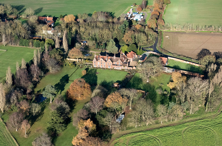
By 2023 the gardens are still laid out with a number of hedged enclosures to the rear and lawns dotted with mature trees, both deciduous and coniferous, separated from the front gardens by an ornate trellis-effect, semi-open brick wall of unknown date, that takes in the full width of the plot to the west. This brick walling is mirrored along the boundary with the road. East of the house the brick wall forming the northern side of the earlier kitchen garden and shown on the 1903 OS map survives. Its western end nearest the house is slightly higher to accommodate a glasshouse behind, also shown on the map. The eastern boundary wall beside the road is a combination of brick and cobbled flint walling of a yard behind the old stables, probably dating to the early-nineteenth century, and newer solid brick walling further east.
SOURCES:
Birch, Mel, Suffolk’s Ancient Sites Historic Places, 2004.
Copper, E. R. ‘Agnes Strickland and her birth-place’ in Suffolk Institute of Archaeology and History, Proceedings, Vol XXIV, Part 1, 1946.
Hoppitt, Rosemary, Deer Parks of Suffolk 1086–1602, 2020.
Kelly’s Directory of Suffolk, 1896.
Moodie, Susanna, Letters of a Lifetime, 1993
Peterman, Michael in the Peterborough Examiner, 24 November, 2017.
White, William, History, Gazetteer, and Directory of Suffolk, 1844, 1874.
https://suffolkwildlifetrust.org/reydonwood (accessed April 2022).
https://miladysboudoir.net/2012/07/29/strictly-agnes-strickland/ (accessed April 2022.)
Census: 1851, 1861, 1871, 1881, 1901, 1911.
Hodskinson’s Map of Suffolk in 1783.
1841 (tithe map 1839) and apportionment.
1883 (surveyed 1882 to 1883) Ordnance Survey map.
1903 (revised 1903) OS map.
1928 (revised 1925) OS map.
2022 Google aerial map (Imagery © Bluesky, CNES / Airbus, Getmapping plc, Infoterra Lts & Bluesky, Maxar Technologies, Map data © 2022).
Heritage Assets:
Reydon Hall (Grade II). Historic England No: 1182329.
Suffolk Record Office (now Suffolk Archives):
SRO (Ipswich, The Hold) 1025/3/1. Title Deeds and Related Papers (1631–1901.
SRO (Ipswich) 1025/3/17. Evidence of Title for the Purchased by Bradford Wilmer.
SRO (Ipswich) HD 2833/2/SC336/1. Sales Particulars for Reydon Hall Estate, 1865.
SRO (Ipswich) 1025/3/1/24. Evidence of Title and Sales Particulars for Reydon Hall Estate, 1886.
SRO (Ipswich) 1117/336/2. Sales Particulars for Reydon Hall Estate, 6 September, 1949.
SRO (Ipswich) 1117/336/5. Sales Particulars for Reydon Hall Estate, 6 October 1954.
SRO (Ipswich) 1117/336/34. Sales Particulars for Reydon Hall, nd (2011).
Site ownership: Private
Study written: February 2023
Type of Study: Desktop
Written by: Tina Ranft
Amended:
