(the house historically known as The Rookery)
Parish: YOXFORD
District Council: EAST SUFFOLK (previously Suffolk Coastal)
TM 400 683
Not open to the public except for booked holiday accommodation
Today often referred to as Rookery Park, the house that sits at the heart of the Rookery Estate was historically called The Rookery. It is c. 6.5km (4mls) north of Saxmundham in the village of Yoxford. In an area known as the ‘Garden of Suffolk’, it is one of three country houses set in parkland surrounding the village, Grove Park and Cockfield Hall being the others. The village derives its name from a ford of the River Yox that runs from the west through the village, becoming the River Minsmere as it flows into the North Sea to the east. The coastal town of Southwold is c. 13km (8mls) to the north-east. The Rookery parkland is on the eastern edge of the central Suffolk clay plateau gently sloping down to the river valley to the north. The main entrance lodge to the park lies at the intersection of the A12 between Ipswich and Lowestoft and B1122 from Yoxford through Middleton Moor south-eastward to Leiston.
ROOKERY PARK AND ITS OWNERS
A house called ‘Elyanores’ in about c. 3.6ha (9a) is recorded on the site in 1471. To the south there was a tenement called ‘Sucklings’, now known as Rookery Farm, which stands on the southern boundary of today’s park. During the first half of the seventeenth century the Rookery Estate was developed by the Foxe family. On the death of John Foxe, who died without heirs in 1652, his brother-in-law Thomas Dade of Tannington, Suffolk took over the property.
Over the following centuries the estate changed hands a number of times, including when Admiral Vernon (1684–1757) sold to William Ingham in 1729. Hodskinson’s map of 1783 shows a small un-named park as the residence of Richard Crowfoot Esq. (d. 1793), a lawyer working in the area, who was left the property by his business partner William Ingham. Richard lived at the property until his death in 1793 and it was sold to his son William Mumford.
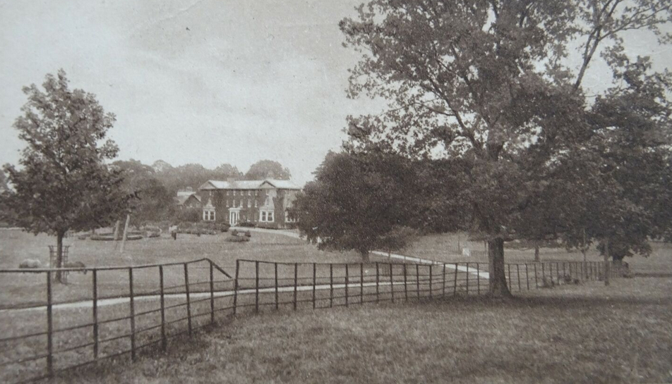
By 1808 Rookery Park was owned by Robert Howlett, a noted Suffolk agriculturalist. He demolished the old house and built the present hall on the same site. After Howlett’s death in 1833 the estate was unoccupied, bought by the Revd Dr Roberts, Vicar of Yoxford, and then by Robert Colmer (d. 1842), who is thought to have added the conservatory and two projecting wings to the rear of the house shown on the 1884 OS map. There followed three decades during which the house was variously owned or tenanted. Although sales particulars survive dated 1888, it is unclear who owned Rookery Park or whether it was sold at the time.
In 1896 the property was sold to George Rose, Esq. who died only three years later. He was followed by Edward Leigh Heseltine who inherited the estate and remodelled the house during the early-twentieth century and built additional service buildings incorporating the original stable block. A new detached stable and coach house yard was built in 1902. This has a central arched entrance topped by a clock turret. Between c. 1909 and 1914 a Mr F. S. Lowe lived at the house and soon after he left, the estate of c. 73ha (180a) was for sale by auction, but withdrawn when it didn’t reach the reserve price, perhaps due to the beginning of World War I.
In 1922 the Rookery Estate was purchased by Sir Herbert Henry Hambling, a member of the board of directors of Barclays Bank who was awarded a Baronetcy in 1924 for his work in the development of civil aviation and is still owned by the Hambling family today. The Rookery mansion house retains a number of historic architectural features, but due to later alterations is not listed by Historic England.
THE PARK AND GARDENS
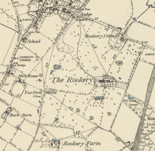
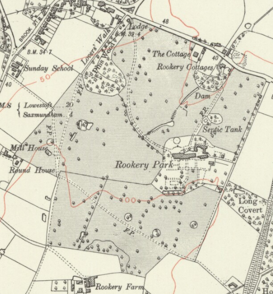
It is unclear when the fifteenth-century tenement called ‘Elyanores’ was enlarged and developed. However, surviving ancient oaks and a field for a dovehouse that appears on an estate map of 1792 suggest this was a late-eighteenth century designed landscape that developed from pre-existing fields and hedgerow trees. By the time of the map accompanying the 1839 tithe apportionment the landscape had a distinct parkland character including trees in small clumps and a curving boundary shelterbelt of trees shielding the park from the village houses to the north-west. Beside this shelterbelt there is an ancient track, now a public footpath called ‘Lovers Walk’, that has its northern end beside the main entrance into the park. The map also shows a small horseshoe-shaped clump of trees surrounding a farmhouse north of the house and beside the road between Yoxford and Leiston. In 1984 this farmhouse was called Rookery Cottages (Grade II) and described as three cottages in its listing from Historic England, although today it appears to be one property. To the south, the tithe map depicts a square shaded feature, approximately centred on the house, that was presumably a garden. Within the parkland further south a large rectangular pond, much like an ornamental canal, is depicted.
The 1884 OS map shows the East Suffolk Railway line that opened in 1859 east of the park. This must have had an effect on the quiet and tranquillity of the house and its setting, perhaps the disturbance leading to the many changes of ownership and tenants over the following years. The parkland had old hedgerow trees that were once field boundaries supplemented by additional trees, some in clumps. By this time a thatched lodge in the cottage orné style stood at the northern entrance into the park beside a curved shelterbelt of trees and Lovers Walk. The drive took a gentle curve through the parkland to arrive at the house, whilst a more direct route was taken by a footpath that enters a belt of trees north of the stable block, perhaps an indicator of an older route of the drive. Within twenty years this footpath had gone. To the north of The Rookery a stream flowed through a U-shaped clump of trees around ‘Rookery Cottage’, the old farmhouse, making its way northward to join the River Yox. Also in this northern section of the park was a larger clump of trees surrounding a small pond. A further footpath led from the stable block, skirted the clump of trees and joined the road between Yoxford and Leiston. The main drive curved through parkland to the north-facing entrance front of the house and onward through a belt of trees into an open courtyard area in front of the attached service wings and stable yard east of the house.
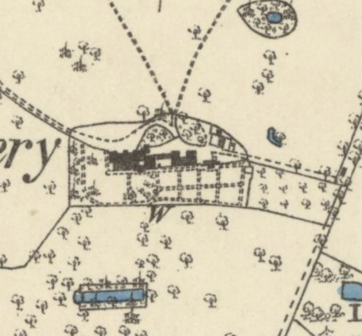
By 1884 the house lay in an approximately rectangular garden enclosure with views over the surrounding parkland to the north, south and west. There were open views from the north-facing entrance front of the house, although a barrier of some description, possibly a fence or ha-ha, separated the gardens from the parkland, where animals were likely grazing. A partly-walled kitchen garden with a perimeter and cross-paths creating eight sections was behind the stables. It appears to have been open on both west and south sides with paths leading out into the pleasure gardens that wraps around the house to south and west. An orchard lay to the east of the walled garden. To the south of the house was a lawn with central path to a focal point, probably a statue or urn at the edge of the outer garden enclosure. Further south was the rectangular canal-like pond depicted on the tithe map surrounded by, what appears to be, a formal walkway and trees that lay outside of the garden enclosure and within parkland but visible from the house.
The addition of the new detached stable and coach house yard north-east of the house in 1902 appears to have created opportunities for changes to the design and layout of the gardens. By 1928 they had expanded eastward taking in the partly-walled garden and orchard. South of the house lawns were dotted with ornamental trees and cross-paths that led towards the garden canal which was now part of the expanded garden. Immediately north of the house a circular garden had developed and in the north park the stream flowing northward to join the River Yox had been damned to create two small serpentine lakes.
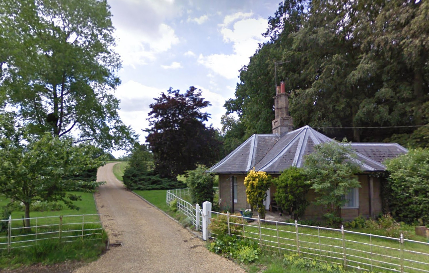
Many of the park features shown on the 1928 map have survived into the twenty-first century. The main drive is still from the north where the entrance lodge survives, albeit now with slate roof. By 2025 new decorative wrought iron gates had been added across the drive. Freestanding trees and clumps, mainly oak, still dot the southern parkland, including some from the eighteenth century or earlier, and boundary plantings to the north-west and north of the house have also survived. Recently, the early-twentieth century ponds to the north of the house have been re-lined and expanded to create a serpentine series of lakes.
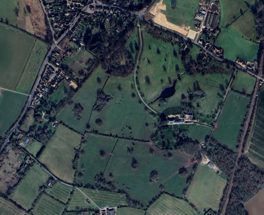
Today the pleasure grounds around the house include substantial plantings of trees and shrubs, such as cedars, pines and sequoias, many dating to the nineteenth century. A lawn to the north of the house includes a circular low yew hedge and symmetrically planted specimen yews, probably dating back to the early-twentieth century and shown on the 1928 OS map. To the south of the house restoration work has recently been done on the amphitheatre-like lawns and the canal-like pond has become a swimming pool. Remains of the gardener’s bothies, glasshouses and a wall from the earlier walled garden have also survived. A number of the buildings on the estate are now available as holiday rental accommodation.
SOURCES:
Birch, Mel, Suffolk’s Ancient Sites Historic Places, 2004.
Cary, John, Cary’s New Itinerary: Or, An Accurate Delineation of the Great Roads, Both Direct and Cross throughout England and Wales, 1828.
Copinger, W. A., The Manors of Suffolk, Vol. 2, 1905.
Spooner, Sarah, Regions and Designed Landscapes in Georgian England, 2015.
Parr, R., T., L., ‘Two Towns in Blything Hundred’ in Suffolk Institute of Archaeology and History, Proceedings, Vol. XXV, Part 3, 1951.
Taigel, A. (UEA) & Williamson, Tom, ‘The Rookery, Yoxford’, Suffolk County Council Survey of Parks, Dec 1992.
White, William, Directory of Suffolk, 1844, 1874.
http://www.suffolklandscape.org.uk/landscapes/Rolling-estate-claylands.aspx org (accessed January 2016).
http://www.rookerypark.org (accessed March 2025).
http://www.thomashoblyn.com/portfolio/residential_gardens/rookery-park-suffolk (accessed 6 January 2016).
Census: 1851, 1861, 1871, 1881, 1891, 1901, 1911.
1843 (surveyed 1840) tithe map and apportionment.
1884 (revised 1882 to 1883) Ordnance Survey map.
1905 (revised 1903) OS map.
1928 (revised 1925) OS map.
1950 (revised 1946) OS map.
2021 Google aerial map (Imagery © Bluesky, CNES / Airbus, Getmapping plc, Infoterra Lts & Bluesky, Maxar Technologies, Map data © 2021).
Heritage Assets:
Suffolk Historic Environment Record (SHER): YOX 013.
Rookery Cottages, 1-3 Middleton Road (Grade II), Historic England No: 1200791.
Rookery Park – Yoxford, Historic England Research Records, Hob Uid: 1519228.
East Suffolk District Council (previously Suffolk Coastal) Supplementary Planning Guidance (SPG6), 1995.
Suffolk Record Office (now Suffolk Archives):
SRO (Ipswich) IR 30/33/487. Tithe map of Yoxford, 1840.
SRO (Ipswich) HB 26/412/1665. Particulars and plan of the Rookery Estate, Yoxford, 1884.
SRO (Ipswich) HB 26/412/1666. Particulars and conditions of sale, with plan, of the Rookery Estate, Yoxford, 1888.
SRO (Ipswich) HD 1678/159/7. Plan of the Rookery estate, in the parishes of Yoxford, Middleton and Kelsale, 1888.
Site ownership: Private
Study written: March 2025
Type of Study: Desktop
Written by: Tina Ranft
Amended:
