(formerly Rushford Lodge or The Lodge)
Parish: EUSTON
District Council: WEST SUFFOLK (previously St Edmundsbury)
TL 927 811
Not open to the public
Before boundary changes in 1894 Rushford Hall (Grade II) was in Norfolk but today, although the village of Rushford is still in Norfolk, the site of the Hall is in the parish of Euston in Suffolk, it being just south of the Little Ouse River, which forms the boundary between Norfolk and Suffolk. The house is c. 6.5km (4mls) south-east of Thetford in an area of sandy soil and heathland that was home to sheep and rabbit warrens until eighteenth century landowners began planting trees and converting the land for farming purposes.
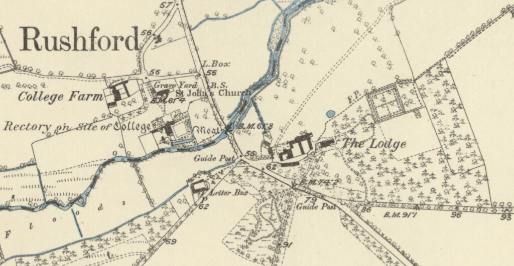
Formerly known as Rushford Lodge or The Lodge, it is believed the Hall had been a manor house that was enlarged in the early-eighteenth century to create a substantial country house. A house appears to be on the site and named ‘Red House’ on Kirby’s 1736 map of Suffolk. It was the seat of Thomas Crookenden, Esq. in the late-eighteenth and early-nineteenth century, who made his money from sugar plantations in Barbados and St Vincent that probably financed the development of Rushford Hall’s parkland. The 1837 OS map shows the house, at the time named ‘Lodge’, with stables and farm buildings to the west and a square walled garden to the north-east. On his death in 1842 the Rushford Estate of about 485ha (1,200a) was bought by Sir Robert Jacob Buxton, Bart. Sir Robert lived in a newly-built mansion at Shadwell Court on the north side of the river, with tenant farmer Robert Ringer living at Rushford Lodge by 1854.
By the time of the 1883 OS map, when in the ownership of the Buxton family, the Hall looked over a small area of parkland meadows to the north where there were some isolated trees and one line of trees that were presumably the remains of a field boundary. Stables and farmyard buildings lay to the west of the house and paths led to a square walled garden at a slight distance to the north-east that is shown on the earlier 1837 OS map and likely to have been built for Thomas Crookenden. This garden had perimeter and cross-paths but seems not to have had a glasshouse. Beyond there was an orchard and to the south an open area within a plantation, which may have been set aside as a paddock or for other sporting activities. There appears to have been no formal gardens, just parkland to the south and east. The area to the south had an in-and-out drive flanked by coniferous planting to the east and a more open parkland area with deciduous trees to the west.
The Buxton family continued to own the Rushford Estate until 1898 when both Rushford and Shadwell estates were bought by John Musker, who created the famous Shadwell stud farm. The Musker family extended the house in the early-twentieth century and housed their polo ponies in the Rushford stables. There was little change in the parkland and gardens over the following century, although by the middle of the twentieth century the most southerly drive had gone.
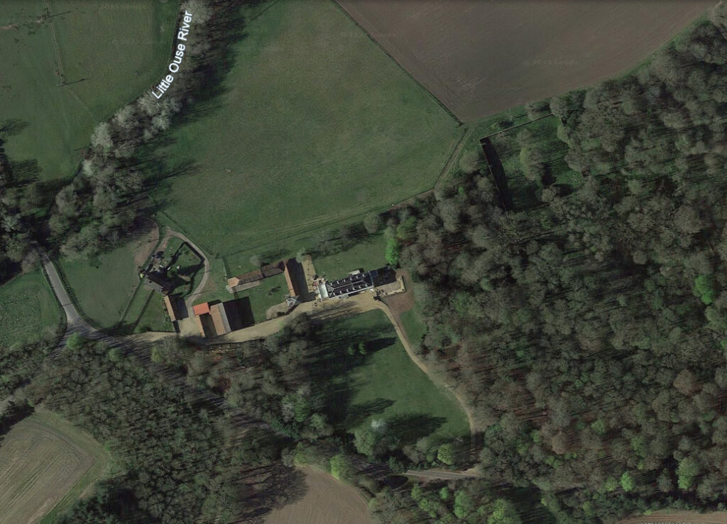
In 1977 the Rushford Estate was bought by the Chambers farming family and for the next forty years they specialised in growing mainly high-yielding root crops, in particular asparagus. By the time of a sale in 2009 the estate included 3.25km (2mls) of river frontage, an established shoot, nine cottages and farm buildings and totalled 496ha (1,225a). It was bought by a property investment company who have a number of other farms in East Anglia. The estate is now run by a farm manager and much is productive farmland, but there are c. 117ha (290a) of meadows, woodland, parkland and gardens. Today the enlarged house has an enclosed lawn to the north, and small area of parkland to the south. Earlier plantations have grown and expanded to the east, within them the remains of the walled garden survives although now uncultivated and fairly overgrown.
SOURCES:
Alston, L., Archaeological Record: Barn & Coach House, Rushford Hall, Euston, Suffolk, 2010. Unpublished document for Suffolk County Council Archaeological Service (accessed August 2018).
Birch, Mel, Suffolk’s Ancient Sites Historic Places, 2004.
Country Life, Sales particulars, May 2009.
White, Francis, History Gazetteer, and Directory of Norfolk, 1854.
Centre for the Study of the Legacies of British Slavery, https://www.ucl.ac.uk/lbs/search/ (accessed October 2023).
Court of Probate case Crookenden v Fuller, https://www.ucl.ac.uk/lbs/person/view/4526 (accessed August 2018).
Rushford Estate, http://www.rushfordhall.co.uk/default.htm (accessed August 2023)
Kirby’s 1736 map of Suffolk.
Hodskinson’s Map of Suffolk in 1783.
1837 Ordnance Survey map.
1883 (surveyed 1881 to 1883) OS map.
1905 (revised 1903) OS map.
1953 (revised 1950) OS map.
Google aerial image (Imagery © Bluesky, CNES / Airbus, Getmapping plc, Infoterra Lts & Bluesky, Maxar Technologies, Map data © 2023).
Heritage Assets:
Suffolk Historic Environment Record (SHER): EUN 032.
Rushford Hall (Grade II), Historic England No: 284162.
The Buxton Papers, 1160–1926, held by Cambridge University Library: Department of Manuscripts and University Archives.
Site ownership: Private
Study written: October 2023
Type of Study: Desktop
Written by: Tina Ranft
Amended:
