(formerly known as Yoxford House)
Parish: YOXFORD
District Council: EAST SUFFOLK (previously Suffolk Coastal)
TM 398 687
Open to the public as a hotel and restaurant
Nestled in the valley of the River Yox which flows east to become the Minsmere River and onward to the coast and North Sea, the village of Yoxford is on the edge of the High Suffolk claylands plateau where it abuts the sandy soils of the coastal strip. It is c. 13 km (8mls) south-west of the coastal town of Southwold. The Ipswich to Lowestoft main A12 road cuts through the eastern edge of the village, which allowed it to became a prosperous trading and communications centre in the late-eighteenth and early-nineteenth centuries. The village is surrounded by mature landscaped and wooded grounds of three country houses, Cockfield Hall, The Rookery and The Grove, all landscaped or re-landscaped in the late-eighteenth or early-nineteenth century.
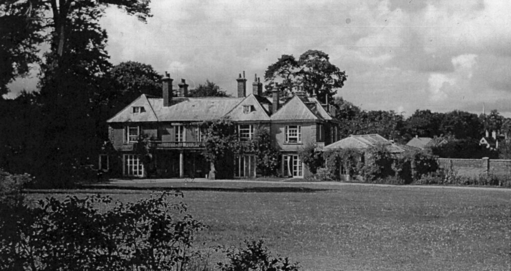
With parkland of Cockfield Hall immediately to the north, Satis House (Grade II) lies on the south side of the river and beside the main road. It was originally built as one of the larger village houses in the mid-eighteenth century but has later alterations and extensions and was formerly known as Yoxford House. The first documented owner was Dr George Wilson, who appears on the 1839 tithe apportionment with a ‘house, garden and meadow of c. 3 acres’. In 1870 it was described as one of the ‘chief residences’ in Yoxford when the home of William A. Collins QC. During the first half of the twentieth century it was owned by Lt Gen. Sir Herbert Scott Gould Miles (1850–1926), best known as the Governor of Gibraltar during World War I, and after his death his widow Lady Alice Miles CBE.
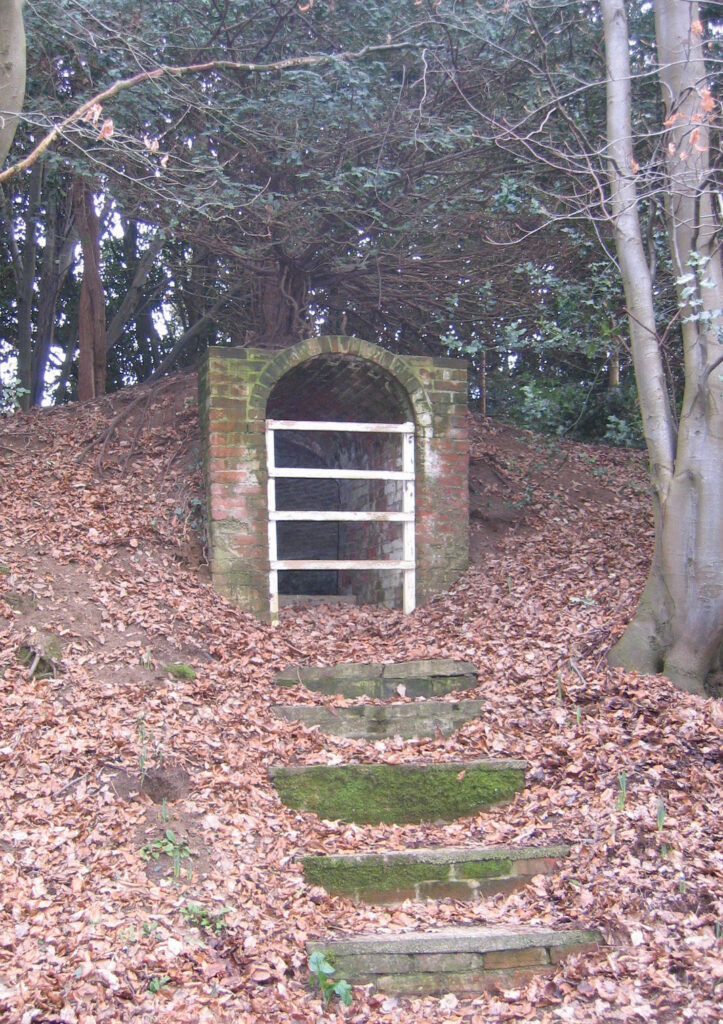
The tithe map, surveyed 1840 and associated with the 1839 tithe apportionment, shows a U-shaped house in the south-west corner of the grounds, a few smaller buildings to the north, shelterbelt of trees along the eastern boundary with the main road and an island formed in the river on the northern boundary. By 1884 the main entrance was, as today, from the north-east with a drive passing a stable yard, small walled garden and onward to the house. The crinkle-crankle east wall of the walled garden is at a low height so allowing views into the garden from the drive and pleasure grounds. Lawned grounds dotted with ornamental deciduous and coniferous trees had a perimeter path, cross-path and belt of trees on the boundary with the road to the east. Once marshland, an area to the north had been planted with coniferous and deciduous trees. An irregular elongated pond, created from the river, lead east towards a surviving icehouse built into the embankment of the road. It is thought to be from the early-nineteenth century, although could date to the construction of the original house in the mid-eighteenth century. What appears to be a summerhouse, possibly on a mound, sat beside the river and pond, probably with views of the parkland of Cockfield Hall. A separate building with attached orangery lay just north of the house. Attached to the orangery was a small walled garden, probably built in the mid-nineteenth century, with crinkle-crankle east wall that extended to the stable/coachyard. This garden had a small glasshouse in the north-east corner and was part of the pleasure gardens, probably with a few fruit trees.
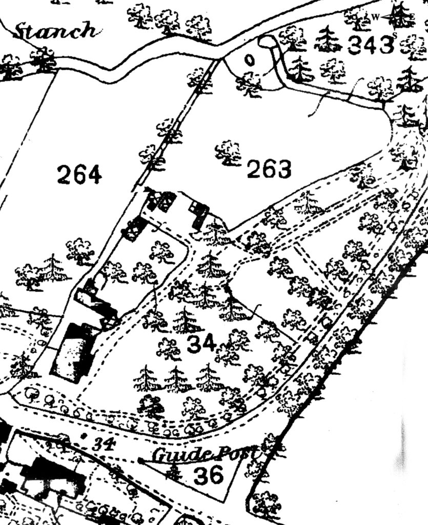
By 1904 the stables had been extended and an additional summerhouse built near the pond. Few changes took place over the following fifty years except the loss of the glasshouse in the walled garden. A century later the summerhouses had gone, the stables had been converted to residential use and, with the pond and northern garden area, were in separate ownership.
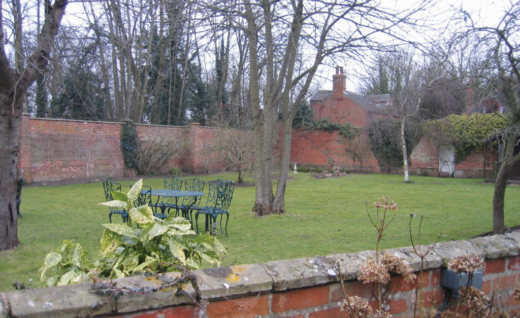
Satis House is now a hotel and restaurant, its remaining grounds after the northern area became a separate property have changed little since 1884. There are a number of surviving nineteenth century trees such as Cedar of Lebanon and Wellingtonia, and it has been described as a ‘significant designed landscape’ of Yoxford village.
SOURCES:
Burke’s Peerage, Baronetage & Knightage, 107th Edition, Vol. 1, 2003.
Kelly’s Directory of Cambridgeshire, Norfolk and Suffolk, 1937.
Suffolk Gardens Trust, Walled Kitchen Gardens Recording Group Report, Satis House, Yoxford, Walled Garden, unpublished document, 2009.
White, William, History, Gazetteer and Directory of Suffolk, 1844.
Wilson, John, Marius, Imperial Gazetteer of England and Wales, 1870–71.
Yoxford Draft Conservation Area Appraisal and Boundary Review, February 2019, East Suffolk District Council.
Census: 1861, 1871, 1881, 1911.
1839 (surveyed 1840) tithe map and apportionment.
1884 (surveyed 1882 to 1883) Ordnance Survey map.
1905 (revised 1903) OS map.
1928 (revised 1925) OS map.
1950 (revised 1946) OS map.
2025 Google aerial map (Imagery ©2025 Airbus/ Copernicus, Maxar Technologies, Map data © 2025).
Heritage Assets:
Suffolk Historic Environment Record (SHER): YOX 002, YOX 006, YOX 034.
Satis House (Grade II), Historic England No: 1200636.
Suffolk Record Office (now Suffolk Archives):
Suffolk Archives (Ipswich) K681/1/524/12, Postcard, mid-20th century.
Suffolk Archives (Ipswich) HD2650/1/1/322/2, Captain Dunlop’s photographs of Yoxford, 1985–2003.
Site ownership: Private
Study written: August 2025
Type of Study: Desktop and site visit 2009.
Written by: Tina Ranft
Amended:
