Parish: SOTTERLEY
District Council: EAST SUFFOLK (previously Waveney)
TM 459 852
Not open to the public except for special events for charity

Sotterley Hall (Grade I) and the Church of St Margaret (Grade I) stand side-by-side and isolated in the centre of a circular, gently-undulating eighteenth century landscape park. It is c. 8km (5mls) south-east of Beecles within the agricultural parish of Sotterley with its dispersed settlement. The park is on the edge of Suffolk’s central clay plateau and lies mainly on heavy boulder clay where many oaks grow, although there are also areas of light sandy soils more suitable for pines. A stream winds its way through the park from the western boundary northward to join the Hundred River which flows eastward towards the North Sea south of Lowestoft.
THE HALL AND ITS OWNERS
The manor of Sotterley was owned by the Playter family from the sixteenth century to 1744. They had a very large manor house that is documented in 1674 as standing beside the medieval parish church and its graveyard with the house having 20–29 hearths standing.
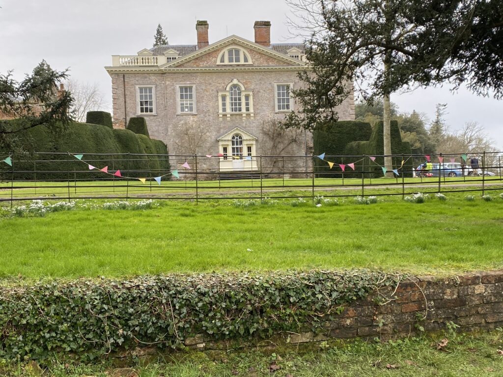
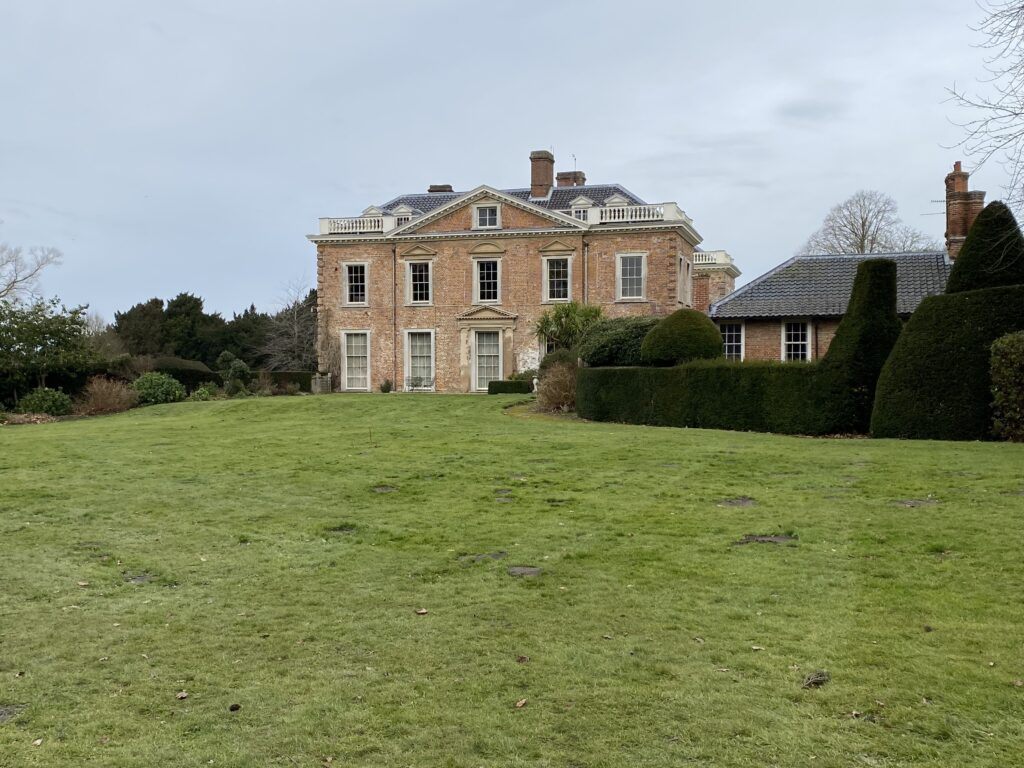
The present Sotterley Hall was built in 1745 for Miles Barne (1718–80), the son of a London merchant who used his inheritance on the death of his father to buy the Sotterley Estate in 1744. He also bought other properties in the area, such as the Reydon Estate in 1746 and most of Dunwich in 1754, the latter allowing him to secure a seat in parliament as MP for this notorious ‘rotten borough’.
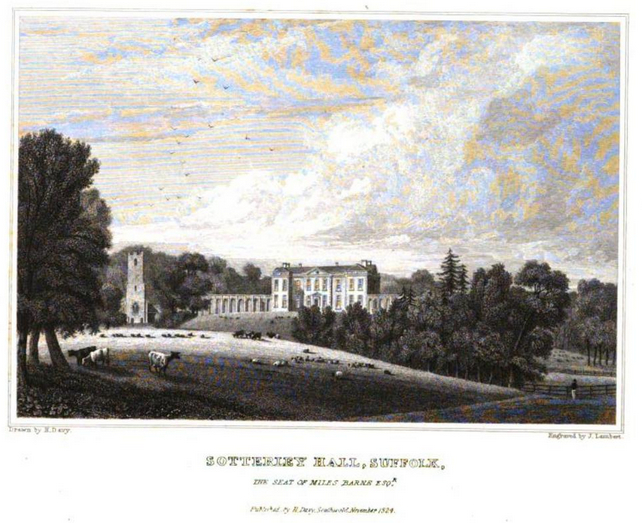
Possibly incorporating elements of the earlier mansion, the Georgian house has many classical elements associated with the period. An engraving of a drawing by Henry Davy dated 1824 shows the H-shaped brick and stuccoed house standing beside the parish church with shallow projecting wings to the north-west-facing front elevation and flanking screen walls to either side that are believed to have been added c. 1820. However, the screen walls were removed soon after, probably at the time the front entrance, curved balustrade and flight of steps were added c. 1840. A service wing (Grade II) attached to the rear of the south wing of the house was built at this time, plus a courtyard of stabling and coach house (Grade II) attached to the rear of the north wing. These were linked by a wall to form an enclosed rear garden, although later the wall was reduced in height to give open views out into the parkland to the east.
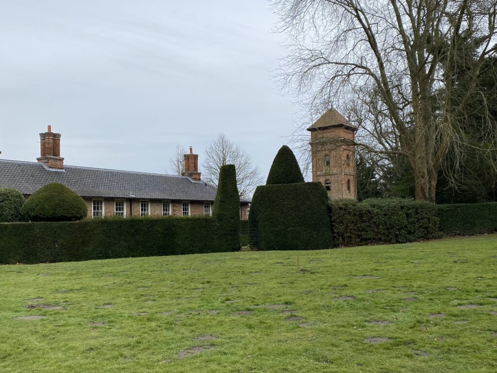
Cowsheds (Grade II) 50m (164ft) east of the house and a water tower (Grade II) to the south-east were added in the mid- and late-nineteenth century and further alterations were made in the early-twentieth century, possibly around the time of the 1901 census when Constance Barne is recorded as a widow living at the Hall with her three children, a niece and fourteen servants.
Today the Sotterley Estate continues to be owned and run by the Barne family. It consists c. 950ha (2,347a) arable land, c. 175ha (424a) woodland, parkland, mansion and its pleasure grounds and a number of holiday cottages including the converted stables and dairy. It is available as a wedding venue and also a film production location.
SOTTERLEY PARK
A park is not mentioned in documents related to the 1744 sale by the Playters to Miles Barne, which state that the c. 375ha (930a) Sotterley Estate consisted entirely enclosed land. However, field names suggest a deer park once existed to the north of the house site but was probably not functioning at the time. These documents describe the mansion within an area of c. 6.5ha (16a) that included stables, granaries, walled and kitchen gardens, orchards and courtyards. There was a summer house beside a ‘broad area of water’ created from the tributary of the Hundred River plus a dovecote. Disturbance under pastureland within today’s park has been suggested as possibly the remains of a deserted medieval village, thus the village was originally closer to the manor house than today.
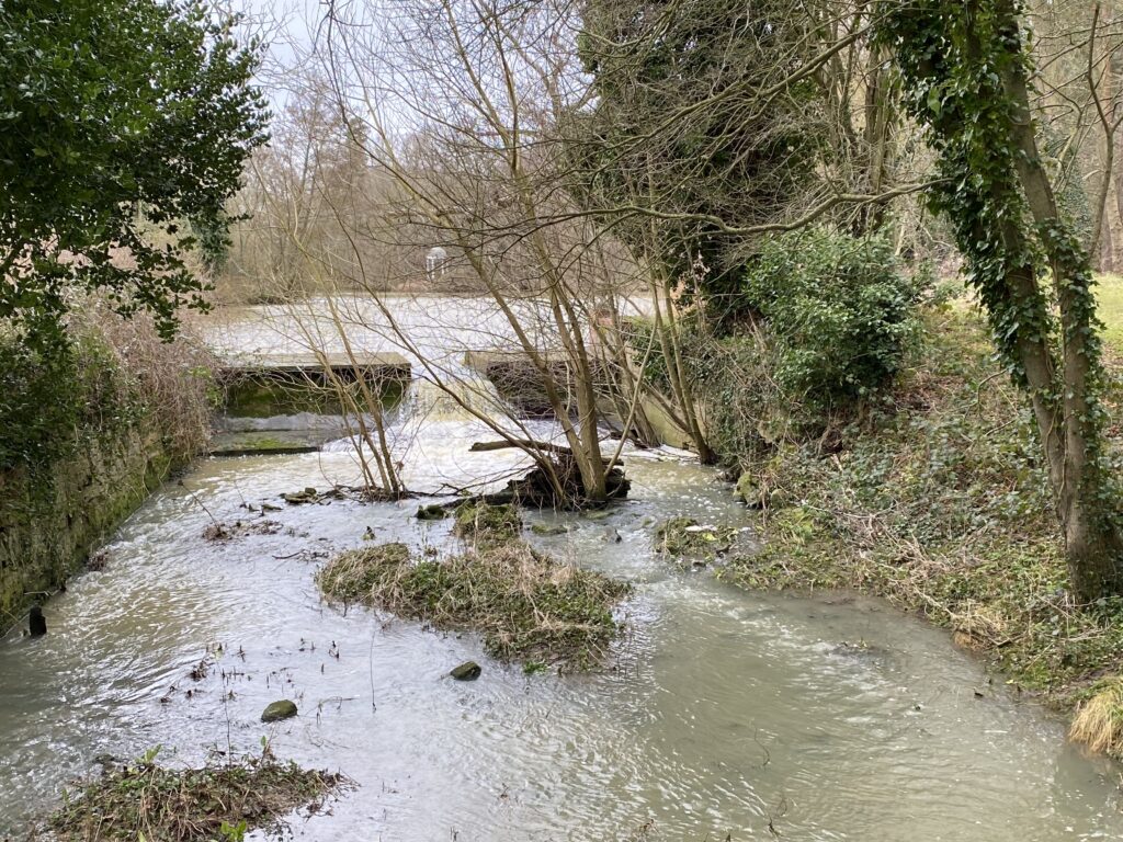
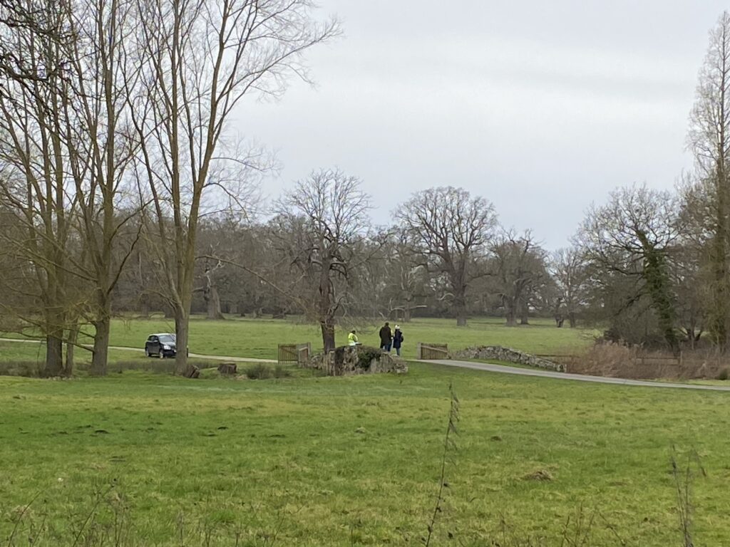
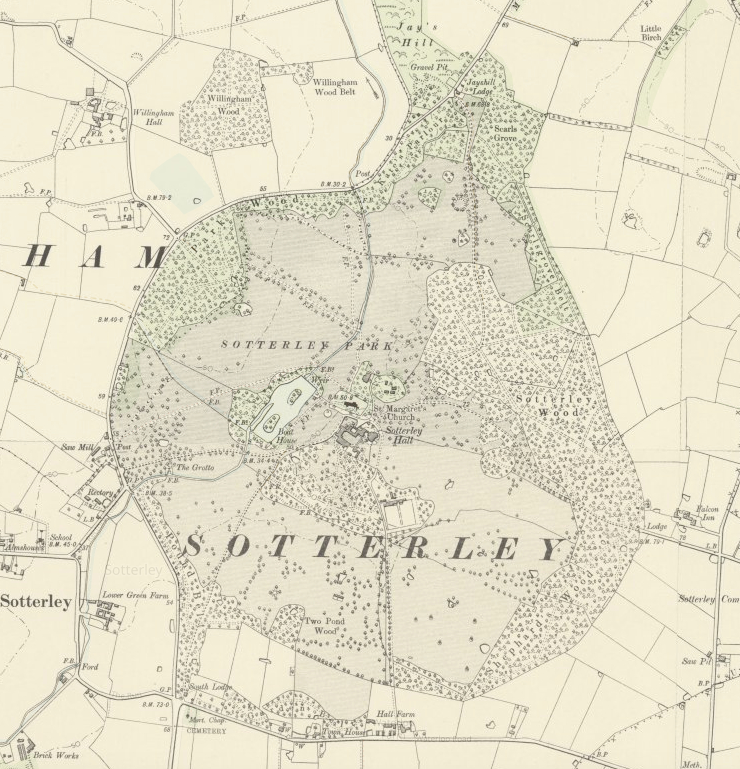
The closure of the roads in 1746, which crossed the site approximately north to south and east to west and joined at a crossroads by the church and mansion, allowed Miles Barne to create his new circular landscape park. Hodskinson’s 1783 map shows that the roads became private tracks within the park that survive today. The park incorporated areas of ancient woodland, mostly around the perimeter, that gave seclusion and privacy to both the house and from within the park. By this time there was a ha-ha separating the garden enclosure from the parkland and a building to the west of the house and near the west drive that was later named on maps as a grotto. A canal, probably an adaptation of a ‘broad area of water’ mentioned in the 1744 sales documents, is shown on the 1783 map with two islands. At the northern end of the body of water there was a surviving, although heavily restored, retaining dam with brick side walls that created a small waterfall. The tithe map surveyed in 1842 shows the house with an uninterrupted view of the lake and in 1846 the park was described by Alfred Suckling in his History and Antiquities of the County of Suffolk as ‘nearly 500 acres [202ha], finely diversified with ancient timber and thriving modern plantations’.
The remains of the grotto beside the west drive survive today. From its entrance there is a c. 2m (6.5ft) high tunnel that runs for c. 3m (10ft) into an adjacent small mound, referred to by D. E. Davy in his Journal of Suffolk Excursions 1823–1840 as ‘a lump with trees on top in the Hall park – a tumulus?’ Further mounds are dotted around the park of unknown origin. These are often associated with burial mounds, or perhaps the site of a windmill. They may also have been created as mounds from which to view the surrounding parkland.
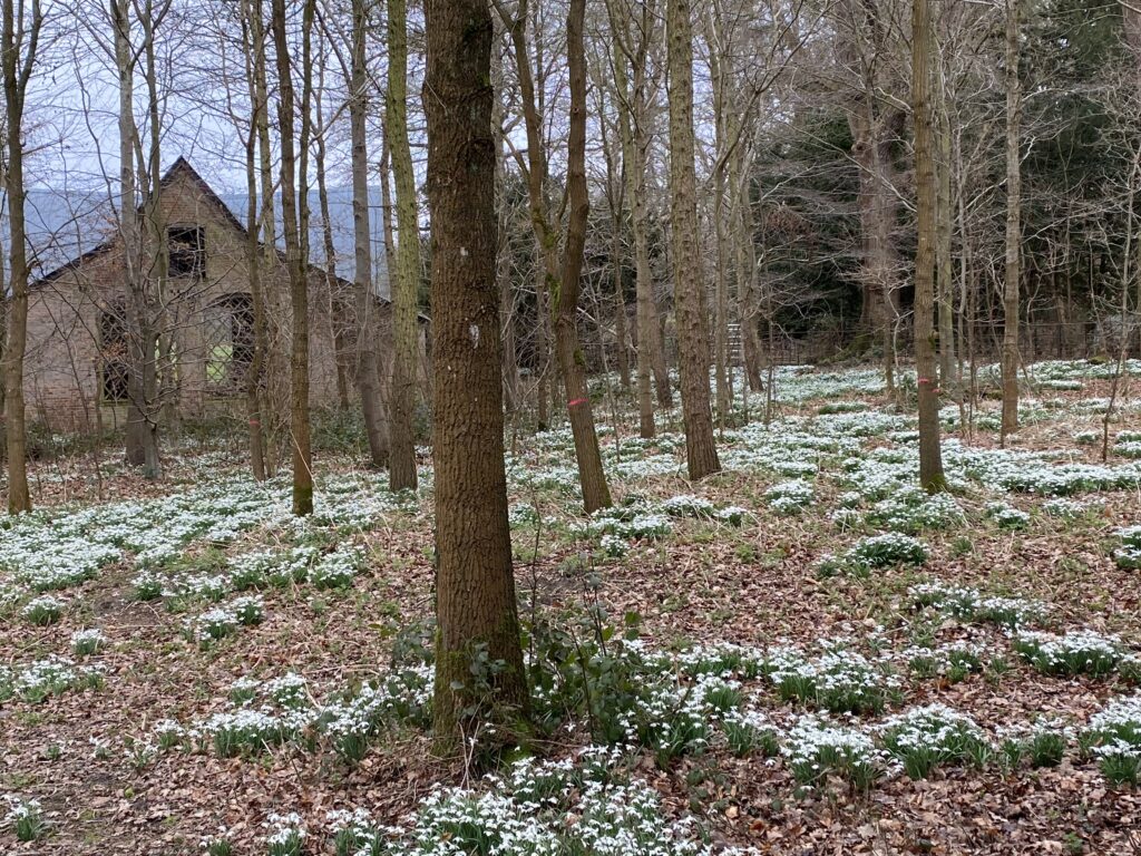
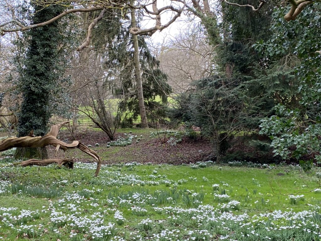
A surviving oval-shaped enclosure north of the church, shown on the tithe map and named ‘Sandpit Garden’ in the 1840 apportionment, appears to be the site of a brick kiln mentioned in the 1744 sales documents. The area was incorporated into the pleasure gardens, although today much overgrown by trees it is covered in a carpet of snowdrops during February.
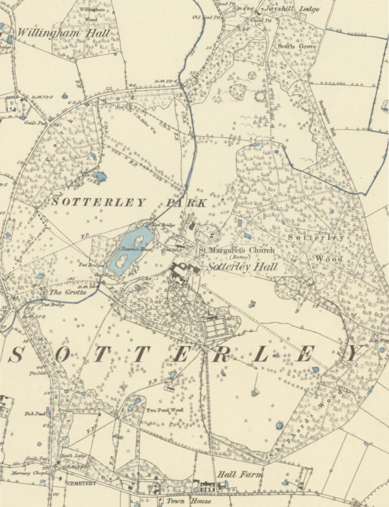
The 1883 OS map clearly shows woods surrounding the circular park made up of groves and belts of trees. The largest are Sotterley Wood to the east, Shephards Wood to south-east and Park Wood along the north-western boundary. There are three lodges shown on the map, these marking the edge of the park and where the original public roads were closed to become tracks within the park.
To the north is the surviving single-storey Jayshill Lodge, probably dating to the nineteenth century. It lies at an entrance into the park with a track seldom used today. This track once had an avenue of Douglas fir with clumps of Wellingtonias, some surviving today, that were probably planted in the 1860s. The drive made its way southward to Sotterley Wood with its numerous criss-crossing ‘rides’ or tracks and onward to the house.
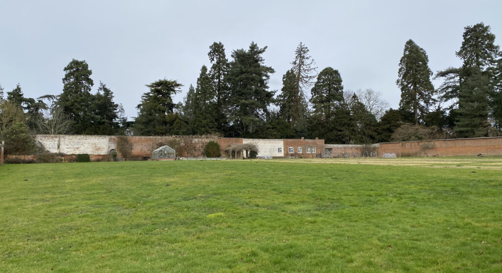
Once at the edge of the parkland, the east lodge now lies within the wider extended parkland area and is only reached by a private track as it makes its way to the north of the house. An entrance directly south of the house is marked by Hall Farm. Not marking an original public road, this gives access to a private track that runs northward passing the walled garden and on to the rear of the house. This too is seldom used today. The nineteenth century farm buildings survive and the farmhouse has been enlarged to create the present residential property.
Slightly south-west of the house and also seldom used, South Lodge is another entrance marking the closure of the public road when the park was created. It is named on the 1883 OS map and the present house is of a similar design to Jayshill Lodge. From here a track passes through Pound Belt before crossing open parkland towards the edge of the pleasure garden enclosure and onward to join the main west drive.
The western main entrance also marked the point where a road was closed, although it appears not to have had a lodge until the late-twentieth century. From here the curving drive passes the grotto and mould before it crosses over the stream via a small surviving eighteenth century bridge and then gently rising towards the house. The bridge is thought to pre-date the present house. The drive has an irregularly-planted avenue of horse chestnuts interspersed with lime.
The lake has two islands that are shown on the late-nineteenth century map but is of a much earlier date and is shown surrounded by planting except to the south-east allowing a view of the lake from the house, much as it is today. A summerhouse is named on the map, although it is not clear exactly where the building was, with a boat house at southern end of the lake. There continues to be a boathouse on the same site, although this appears to be a replacement or heavily-restored nineteenth century structure.

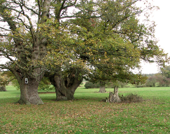
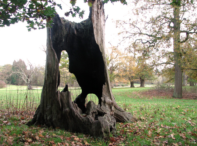
Today the park remains much as it was when first created and extends to over 80ha (197a) and now much of it designated as a Site of Scientific Interest (SSSI). Although there continues to be extensive replanting in addition to that in the nineteenth and twentieth centuries, many trees survive that pre-date the creation of the eighteenth century park, some marking previous lines of hedges that were mostly managed as pollards. Other trees were associated with low banks next to hedges or the roads that were closed before the present park was created. Today much of the park is under grass dotted with a large number of ancient oaks in various states of decay. Other ancient and mature trees of various species are also coming to the end of their lives. The park is still surrounded by a continuous belt of woods and plantations with some arable planting having occurred north-west of the lake.
PLEASURE GARDENS AND WALLED GARDEN
An irregular garden enclosure to the south of the house surrounds the extensive pleasure gardens and the walled garden that have their origins in the eighteenth century. It is bounded by water-filled ditches to the south, a ha-ha and metal fencing to separate it from the surrounding parkland. The current planting in the gardens mainly dates from the nineteenth and twentieth centuries with a combination of mature trees and shrubs and a series of earlier paths have been simplified and mainly replaced by wide lawns, often with long vistas.
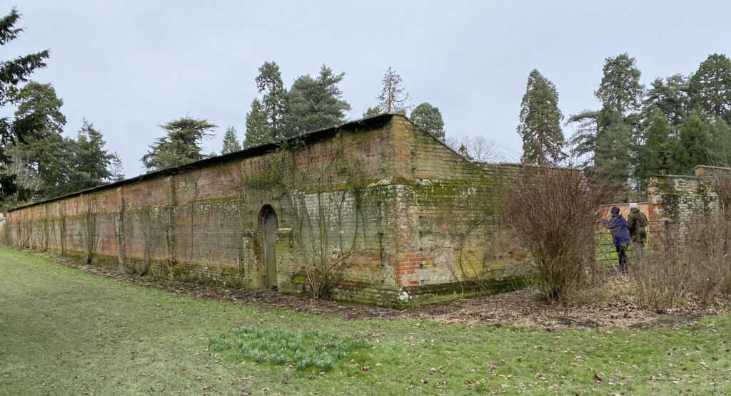
Referred to in the 1744 sales documents and accessed through the wooded pleasure grounds is a large surviving square walled kitchen garden. By 1883 it was laid out with perimeter, central and cross-paths with glasshouses on the south side of the north wall and back sheds behind. The main entrance appears to have been a gateway towards the north-west corner of the garden, which today has an ornamental metal gate of unknown date. A further gateway with wooden gate survives towards the southern end of the west wall. What appears to be a later large opening has been added along the south wall that would have allowed large farm machinery into the garden. Although the walled garden fell into disuse during the late-twentieth century and lost its glasshouses and paths, efforts have recently been made to bring it partially back into use.

Outside the park to the south is Sotterley Cemetery Memorial Chapel (Grade II), an unusual octagonal building possibly to designs by Sir Arthur Blomfield. It was built c. 1885 to replace the churchyard in the park that was closed for burials. To give themselves more privacy, efforts were made by the Barne family to also close the church to villagers, but these eventually failed and worship continued at the Church of St Margaret whilst burials took place at the chapel.
SOURCES:
Beresford, M., The Lost Villages of England. London, 1954; Beresford, M. and Hurst, J. G., (eds), Deserted Medieval Villages, 1971. Information from Department of History, University of Hull (https://www.dmv.hull.ac.uk/dmvDetail.cfm?dbkey=4529&county=true, accessed February 2017).
Birch, Mel, Suffolk’s Ancient Sites Historic Places, 2004.
Davy, David, Elisha, A Journal of Excursions Through the County of Suffolk, 1823–1844 reproduced by The Suffolk Records Society.
Davy, H., Views of the Seats of Noblemen and Gentleman of Suffolk, 1827.
Dymond, David & Northeast, Peter, A History of Suffolk, 1985.
Kelly’s Directory of Suffolk, 1869.
Place Services, East Suffolk Historic Parks and Gardens, East Suffolk D. C., 2021. Review and assessment of five Historic Parks and Gardens within the former Waveney area identified to bring them into the new East Suffolk District Local List of Non-designated heritage assets under Policy SCLP11.8: Parks and Gardens of Historic or Landscape Interest.
Sandon, Eric, Suffolk Houses, A Study of Domestic Architecture, 1977.
Spooner, Sarah, Regions and Designed Landscapes in Georgian England, 2015.
Suckling, Alfred, Indigo, The History and Antiquities of the County of Suffolk, Vol. I, 1846.
Tate, W. E., ‘A Handlist of Suffolk Enclosure Acts and Awards’ in Suffolk Institute of Archaeology and History, Proceedings, Vol. XXV, Part 3, 1951.
The British Architect, August 23, 1889. Getting Rid of the Old Parish Church.
Victoria County History, Suffolk, Vol. 2, 1907.
Wade Martins, Susanna and Williamson, Tom, The Countryside of East Anglia, Changing Landscapes, 1870–1950, 2008.
White, William, History, Gazetteer, and Directory of Suffolk, 1884, 1855, 1874
Williamson, Tom, Suffolk’s Gardens and Parks, 2000.
https://www.sotterleyestate.co.uk/
https://www.britainexpress.com/counties/suffolk/churches/sotterley.htm (accessed January 2021).
https://landedfamilies.blogspot.com/2019/11/396-barne-of-sotterley-hall.html (accessed March 2023).
http://www.visionofbritain.org.uk/place/7697 (accessed January 2017).
Suffolk Landscape Character Assessment https://suffolklandscape.org.uk/ancient-estate-claylands/ (accessed April 2021).
Census: 1851, 1881, 1891, 1901.
Kirby’s 1736 map of Suffolk.
Hodskinson’s Map of Suffolk in 1783.
1842 (surveyed) tithe map and 1840 apportionment.
1883 (surveyed 1883) Ordnance Survey map.
1906 (revised 1903) OS map.
1951 (revised 1947) OS map.
2021 Google aerial map (Imagery © Bluesky, CNES / Airbus, Getmapping plc, Infoterra Lts & Bluesky, Maxar Technologies, Map data © 2021).
Heritage Assets:
Suffolk Historic Environment Record (SHER): SOT 002, SOT 004, SOT 005, SOT 006, SOT 007, SOT 011, SOT 013, SOT 016, SOT 017, SOT 018, SOT 029.
Sotterley Hall (Grade I), Historic England No: 1183257.
Church of St Margaret (Grade I), Historic England No: 1032097.
Service Wing immediately south-east of Sotterley Hall (Grade II), Historic England No: 1032098.
Stabling and Coach House immediately to east of Sotterley Hall (Grade II), Historic England No: 11833266.
Water Tower (including attached Engine House), 60 metres south-east of Sotterley Hall (Grade II), Historic England No: 1183289.
Cow sheds 50 metres east of Sotterley Hall (Grade II), Historic England No: 1032099.
Sotterley Cemetery Memorial Chapel (Grade II), Historic England No: 1391195.
Historic England Research Records, Hob Uid: 392182.
Place Services, East Suffolk Historic Parks and Gardens, East Suffolk D. C., 2021.
Suffolk Record Office (now Suffolk Archives):
SRO (Ipswich) HA53. Deeds, estate and family papers of Barne family, fourteenth to twentieth century.
The National Archives, Kew. SP 36/152/1/1746. Petition to the King from Miles Barne of Sotterley Hall in the county of Suffolk for a licence to inclose part of the common highways. 21–26 April 1746.
Site ownership: Private
Study written: July 2025
Type of Study: Desktop and site visit February 2025
Written by: Tina Ranft
Amended:
